22.7.2024 - Hugh
Bothwell writes: 'Further to your item on the Dales Brickyards, I
thought you might like to see some of my detective work! Apologies in
advance for the quality of the old monochrome photos. Feel free to use
my content if you deem it worthy!'
All photographs courtesy Hugh Bothwell.
 A1
A1
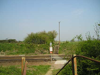
Photo A1 shows a general view of the stile close to Westerfield station (prior to any recent building work).
 A2
A2
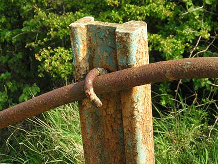
Photo A2 illustrates part of its handrail which suggests to me it was most probably constructed using old narrow gauge rail from the brickworks railway.
 A3
A3
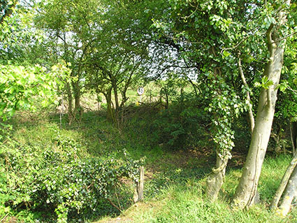
Photo A3 is an attempt to show the overgrown depression of the old narrow gauge track bed of the railway running parallel at it's start next to the main line.
 A4
A4
 A5
A5
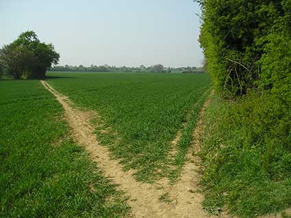
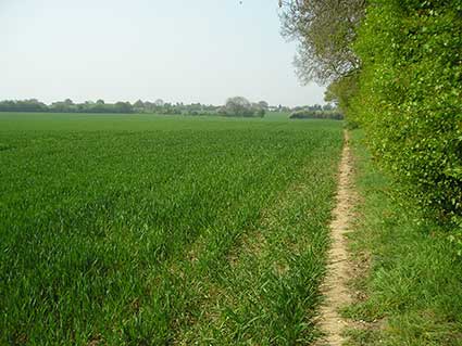
Photos A4 and A5 are general views of the fields (soon to be buried under new housing) across which the railway's course curved across to the left towards The Grove - approximately where the hedges divide the two fields in the middle distance.
Several decades ago there was a booklet in the local library on the history of Ipswich's Forgotten Railway but I have never been able to source a copy of it.
Photos B1, B2 and B3
 B1
B1
 B2
B2
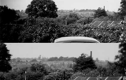
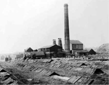
Photo B1 was taken around 1948-50 from a back garden in Dales View Road and in the direction of the Dales brickworks - you will note the chimney and beyond a tree to the left of it a structure which looks rather like a dark grey windmill with no sails. On checking your site, I married this up with Photo B2 and realised the 'windmill' was actually part of the brickworks buildings.
 B3
B3
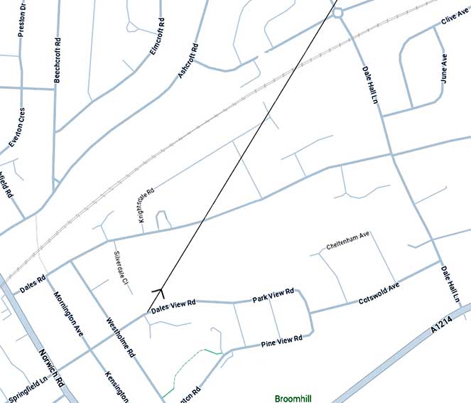
In B3 I have approximated the angle Photo B1 was taken and in B1's inset photo, it shows how much of the countryside on the far side of the main line railway was soon to disappear under the Crofts. I can remember as a youngster being walked up Dales Road in the early 50s and, from the start of the hill around where Wharfedale Road joins Dales Road, it was a sandy track with few completed buildings until the summit was reached where a small general store stood, approx. at the corner of the Emmaus carpark – long before it (and I believe a couple of cottages) were demolished and the Dales Pub built. I believe it was owned by the Mayhews who then ran the pub.
These photos were taken in the early 50s
 A6
A6
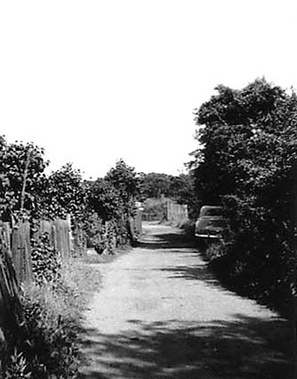
Photo A6 was taken on the lane leading behind 14-72 Dales View Road. The shed had a diesel fuel pump in it and belonged to Wyards Removals who were based at the corner of Westholme and Sherrington Roads. Although it is now overgrown, there is still an earth hump over the tank, which remains there underground.
 A7
A7
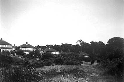
Photo A7 was taken standing by that shed and looks towards the sandpit where the Sherrington House residential home is now. The Nissen shelter on the right was used by the home guard during the war and a barrage balloon was tethered there.
 A8
A8
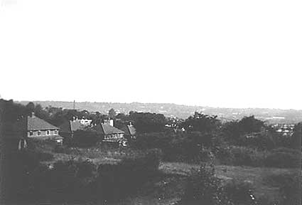
Photo A8. Taken from higher viewpoint ( behind no's 50-60 Dales View Road); in the left hand corner you can see that same shelter and slightly to the right of it the 'white' outline of Broomhill swimming pool. This 'dip' in the land was where the original brickworks mentioned in your Dales Brickworks article: "John Luff of Tuddenham had established a brickworks at the top of Sherrington Road opposite Broomhill Swimming Pool". In August 1961, J.A. Wyard applied to fill the 'dip' and as a consequence, earth from the excavation of the spiral car park in Civic Drive was emptied here and became known as Sherrington Park. [Hugh has found, on the Ipswich Borough Council website, the 'Application for Permission for Development' (3.8.1961) by J.A. Wyard of 25 Sherrington Road; brief description: 'Filling of land'.]
Relevant links
Brickyards in Ipswich
Ipswich's forgotten railway (the Grove and Dales railway)
All photographs courtesy Hugh Bothwell.
 A1
A1
Photo A1 shows a general view of the stile close to Westerfield station (prior to any recent building work).
 A2
A2Photo A2 illustrates part of its handrail which suggests to me it was most probably constructed using old narrow gauge rail from the brickworks railway.
 A3
A3Photo A3 is an attempt to show the overgrown depression of the old narrow gauge track bed of the railway running parallel at it's start next to the main line.
 A4
A4
 A5
A5Photos A4 and A5 are general views of the fields (soon to be buried under new housing) across which the railway's course curved across to the left towards The Grove - approximately where the hedges divide the two fields in the middle distance.
Several decades ago there was a booklet in the local library on the history of Ipswich's Forgotten Railway but I have never been able to source a copy of it.
Photos B1, B2 and B3
 B1
B1
 B2
B2Photo B1 was taken around 1948-50 from a back garden in Dales View Road and in the direction of the Dales brickworks - you will note the chimney and beyond a tree to the left of it a structure which looks rather like a dark grey windmill with no sails. On checking your site, I married this up with Photo B2 and realised the 'windmill' was actually part of the brickworks buildings.
 B3
B3In B3 I have approximated the angle Photo B1 was taken and in B1's inset photo, it shows how much of the countryside on the far side of the main line railway was soon to disappear under the Crofts. I can remember as a youngster being walked up Dales Road in the early 50s and, from the start of the hill around where Wharfedale Road joins Dales Road, it was a sandy track with few completed buildings until the summit was reached where a small general store stood, approx. at the corner of the Emmaus carpark – long before it (and I believe a couple of cottages) were demolished and the Dales Pub built. I believe it was owned by the Mayhews who then ran the pub.
These photos were taken in the early 50s
 A6
A6Photo A6 was taken on the lane leading behind 14-72 Dales View Road. The shed had a diesel fuel pump in it and belonged to Wyards Removals who were based at the corner of Westholme and Sherrington Roads. Although it is now overgrown, there is still an earth hump over the tank, which remains there underground.
 A7
A7Photo A7 was taken standing by that shed and looks towards the sandpit where the Sherrington House residential home is now. The Nissen shelter on the right was used by the home guard during the war and a barrage balloon was tethered there.
 A8
A8Photo A8. Taken from higher viewpoint ( behind no's 50-60 Dales View Road); in the left hand corner you can see that same shelter and slightly to the right of it the 'white' outline of Broomhill swimming pool. This 'dip' in the land was where the original brickworks mentioned in your Dales Brickworks article: "John Luff of Tuddenham had established a brickworks at the top of Sherrington Road opposite Broomhill Swimming Pool". In August 1961, J.A. Wyard applied to fill the 'dip' and as a consequence, earth from the excavation of the spiral car park in Civic Drive was emptied here and became known as Sherrington Park. [Hugh has found, on the Ipswich Borough Council website, the 'Application for Permission for Development' (3.8.1961) by J.A. Wyard of 25 Sherrington Road; brief description: 'Filling of land'.]
Relevant links
Brickyards in Ipswich
Ipswich's forgotten railway (the Grove and Dales railway)
Search Ipswich
Historic Lettering
©2004 Copyright throughout the Ipswich Historic Lettering site: Borin Van Loon
No reproduction of text or images without express written permission
©2004 Copyright throughout the Ipswich Historic Lettering site: Borin Van Loon
No reproduction of text or images without express written permission