Turret
Lane
People have been using Turret Lane for at least a
thousand years. A hollowed-out tree trunk well, discovered in Turret
Lane in the northern limit of the area, was dated by dendrochronology
to approximately 670 A.D. Although originally nothing more than a
lane, there were undoubtedly industries flourishing at the time, many
to do with the functions of the port and shipbuilding in particular.
The archaeologists unearthed several clench bolts and roves, and fish
bones indicating both marine and freshwater fishing. (Information from
Twinch, C.: Ipswich street by street, see Reading
list.)
See our Street name derivations for
Turret House (date of build unknown) and much more about it and its
relationship to Wolsey's College.
 2014 image
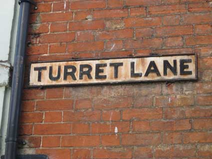
Above: the familiar cast-iron street nameplate with relief frame and
capitals; it is sited in the narrow entry to Turret Lane from Lower
Brook Street – opposite the Haven House
frontage. Clearly not regularly painted, it bears the patina of
years of weathering (see also the sign which once marked Bridge Street.)
 2016 image
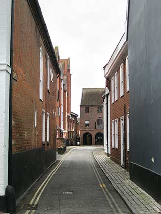
Above: the view from Lower Brook Street down the east-west leg of
Turret Lane, with the street nameplate just visible at left and the
Turret Lane Baptist Chapel past the 'Baltic-style' modern housing at
the left of the lane.
Turret Lane comes off the modern, eastbound 'Eastern Gyratory' road
(Star Lane) cut through the industrial and mediaeval buildings in
1973, north of Wolsey's Gate. It winds its way around industrial
buildings, including the rear of the former East Anglian Daily Times printworks.
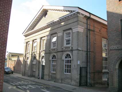
Passing the end of Rose Lane we find the rather fine building below: a
Grade II Listed former Church Hall (the former
Turret Lane Baptist Chapel).
 2014 image
The Listing text reads: "An early-mid C19 red brick
building with a
Suffolk white brick hexastyle front, with brick pilasters and stucco
caps surmounted by a frieze and modillion pediment. 2 storeys on the
front, with windows between the pilasters. The upper storey windows
(blocked) have moulded stone architraves and sills on brackets. The
ground storey windows and central doorway have semi-circular stone
arches." Today this is known as Cavendish House.
Our page about the Sailor's Rest in St
Nicholas Street has a historical aerial view of Silent Street with the
red brick Turrent Green Baptist Church prominent. While the church is
long gone, its associated hall (which Simon Knott tells us is the
former church, hence its rather grand Palladian elevation on Turret
Lane) still
graces the northernmost part of the lane (labelled as 'Sun. Sch.' on
the 1902 map below) just before it turns sharp right rather than run
through the middle of today's Old Cattle Market bus station – although
you can
see the kerbing indicating the line of the old lane bisecting the
tarmac. It is only when
you see the two apparently disparate church buildings together on the
map that
this all fits:
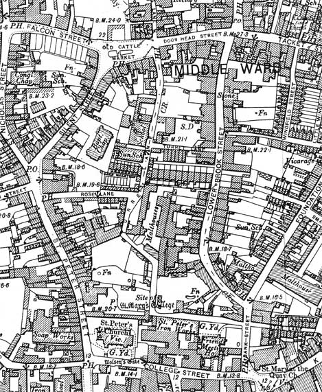 1902
map
1902
map
The 1902 map of the area above shows the variable width
and meanders of the lane which originally also headed north to the end
of
Dogs Head Street – at the site of The
Plough (clearly marked 'P.H.'),
as well as the branch to Lower Brook Street, thus the lane would have
had three legs. The north section of the lane is labelled St Stephens
Lane on the 1778 map (shown on our Wolsey's
College page). The whole length of Turret Lane strikes us as having
been pieced together. Interestingly, the southern end of the lane is
marked 'Site of St Mary's College', that is, the 'Wolsey's College' buildings which were
erected at the order of Cardinal Wolsey
just before his fall from
grace. See our Lady Lane page for more
information and the historical context. In 1902 this end of Turret Lane
was not a T-junction at all but a right angle running east (later to be
known as Star Lane), past St
Peter's Ironworks – presumably an extension to the St Peter's Ironworks
in nearby Foundry Lane – and a graveyard associated with a Friends
Meeting
House, to meet Bank Street, which today we call the southern end of
Foundation Street. It was in 1973 that this was opened up to the north
of St Peter's Church. Carol Twinch (see Reading
list) decribes this road development stretching from Greyfriars
Road to Grimwade Street as "the
great traffic gash that is Star Lane".
See also a close-up map of the Rose Lane
area here for further commentary on the buildings.
Home
Please email any comments
and contributions by clicking here.
©2004
Copyright
throughout the Ipswich
Historic Lettering site: Borin Van Loon
No reproduction of text or images without express written permission