 , Chapman Lane, Wolsey Theatre
When, in the early 1960s, Ipswich
was earmarked by central
government to act as a resettlement area for populations displaced from
the East End of London, it spurred a major shift in policy on civil
engineering and building. The fact that the government policy shifted
again after the building of the Greyfriars complex (1964-66) meant that
the
massive housing estates in south-west Ipswich were never built and the
influx of Eastenders never arrived – being diverted to Haverhill,
Sudbury and Thetford. In addition to the Ipswich
Borough Council attempt to shift the town's centre to a new,
car-orientated, modernist shopping and leisure centre at Greyfriars,
much else changed.
 1902 map
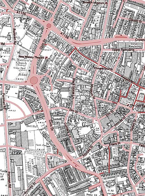
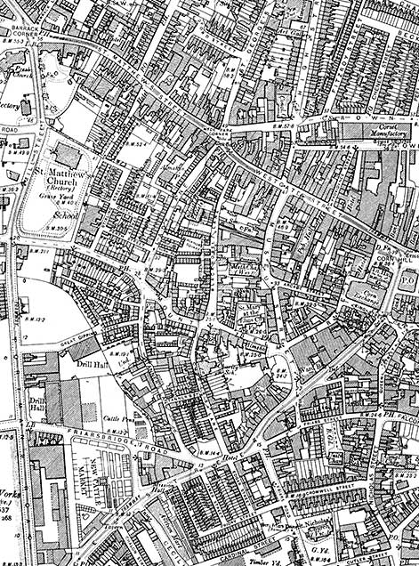
The 1902 map of this area shows a very different street layout to that we see today, as can be seen by overlaying the modern streets in pink, above. See also our page on Black Horse Lane.
The main changes in road routes from St Matthews Street down to Princes Street, turning left into the new dual carriageway of Cromwell Street. At this point, protesters halted the bulldozers which were about to push this new road through ancient buildings in St Nicholas Street, Silent Street, Lower Brook Street, Foundation Street and Fore Street. The last of these was, of course, eventually cut through by the Star Lane 'Eastern Gyratory' traffic system in the 1980s. Those protesters, concerned at the wholesale demolition of the architectural heritage of this ancient town, soon formed The Ipswich Society (see Links) in 1960. Many of the roads and buildings demolished were of poor, working class dwellings, run-down beer houses and old industrial buildings. The hill on which Civic Centre was built had been an area of the town called 'The Mount' and the lanes dropping south from St Matthews Street were Church Lane and Lady Lane. Below Handford Road and Mount Street (running east-west), Lady Lane led down to Tanners Lane which eventually joined Friars Bridge Road and Princes Street. See our Friars Bridge Road page for a 1902 map of the area. The new dual carriageway running from the southern end of Berners Street down to the Greyfriars site more or less followed the lines of Church Lane and Tanners Lane. It was called Civic Drive to reflect its proximity to the group of buildings around the new Civic Centre, law courts and police station block on Elm Street. The reshaping of this part of Ipswich was radical.
See also Lost Ipswich trade signs for Thomas Seckford's 'Great Place' in Westgate Street, destroyed during the cutting-through of Museum Street in the 1840s.
See our 'Ipswich Tomorrow' page for more about the Greyfriars and Willis developments, the Greyfriars timeline and a set of 1968 photographs of the newly built Civic Drive and Greyfriars area.
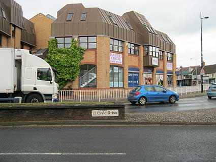
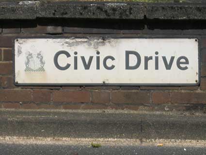
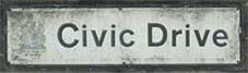
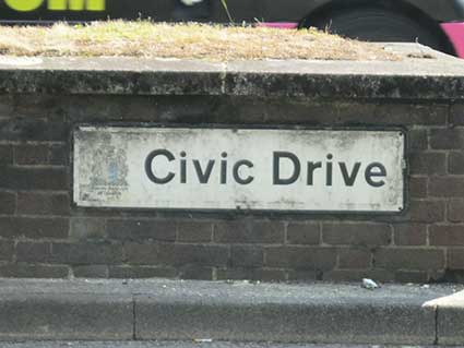
The little-noticed road signs on the brick central reservation on the upper part of Civic Drive are remarkable survivors of those early days. It is probable that their 'difficult' positioning and relatively small size accounts for their survival into the 21st century when so many other street nameplates have been replaced or updated.
 2015 images
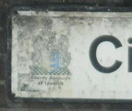
To the left of the sans serif, upper and lower case street name is the vestige of a coloured Ipswich coat of arms. Below that is a small piece of text (which someone has tried to obliterate with paint on the St Matthews end – now discolouring) which is more readable at the end close to St Matthews School:
For more information and maps of the Willis Faber & Dumas building at the bottom of Civic Drive and its effect of the Greyfriars area, see the 'Before Willis' section of our Lost trade sign page.
Bernard Reynolds' Ship sculpture stands in the middle of the Handford Road roundabout on Civic Drive.
The Spiral Car Park
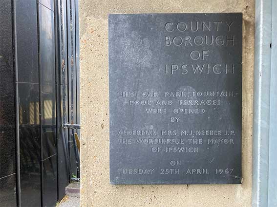
August 2021. Ed Broom, who has contributed several excellent lettering examples to this site, sent this: 'Looking down into the void of the Spiral car park I chanced across this splendid plaque on the left pillar of the entrance. Marjorie Keeble, the 4th woman Mayor of Ipswich, was apparently the first girlfriend of Sir John Mills!' Many thanks to Ed for recording this.
 2022
image courtesy Ed Broom
2022
image courtesy Ed Broom
One of the survivors from the 1960s radical reshaping of the area known as The Mount is a curious car park diving deep below 'Theatre Square'. The Spiral Car Park is described as being an Ipswich landmark – even though there really isn't anything to see in the townscape. Work to build the car park started around 1964 as an integral part of the vision of the town based around car ownership (which also informed the ill-fated Greyfriars shopping centre scheme nearby). Civic Drive was cut through to Princes Street and St Matthews Street was widened despite contractors hitting problems with water springs during excavation work. No doubt the deeper the sprial was excavated, the more water became a problem. This must have been a remarkably adventurous piece of civil engineering as it delves deep into the ground. A black striated structure still stands today at the centre of the spiral and it marks the top of car park's ventilation shaft. The Civic Centre fountain was switched off soon after the opening as car park visitors were often soaked on a windy day.
Constructed by this local sculptor, Bernard Reynolds. in 1971 the following year the Ship sculpture was originally sited at the foot of Civic Centre (now demolished) where it stood in a pool of water. Most people recall it sitting in a dry pool. In 1996 this sculpture was moved from its neglected position to the centre of the Civic Drive/Handford Road roundabout.
Chapman Lane
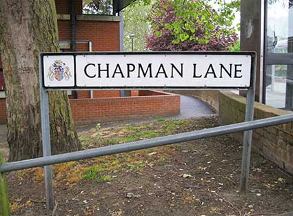 2015 image
Just off the northern stretch of Civic Drive, on the east side is Chapman Lane. It runs behind the Wolsey Theatre buildings and is mainly seen as a service road for deliveries to the rear of shops fronting the eastern section of St Matthews Street and for car parks to the north of the former Civic Centre site. However, it does have an interesting street name derivation. Interestingly, this part of the road is labelled Black Horse Lane on a 1994 street map of the town, so this must be a more recent naming.
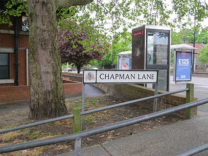
Civic Drive (with central reservation) is in the background; this is a riot of street furniture: bus shelter, telephone kiosk, ramp handrails, street sign and, amongst the trees, parts of the Church of St Matthew.
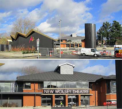
The Wolsey Theatre
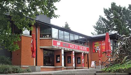 2019 image
Above: the most recent incarnation of the New Wolsey Theatre. As part of the 2020 building of the 'Golden Pavillion' and refurbishment, the NWT sign was removed (see the comparison images below, courtesy of Tim Legget, to whom our thanks).
The theatre building was designed by Roderick Ham for Ipswich & Suffolk New Theatre Trust. Construction was carried out between 1977 and 1979 by Haymills Contractors Ltd with Carr And Angier theatre consultants providing planning advice and design/installation of all technical systems and equipment. From 1979 to 1999 the theatre was operated by The Wolsey Theatre Company, a regional repertory company. The theatre was known for showing performances of drama, comedy and musical plays and was used almost exclusively as a producing house. Due to financial problems dating back to the mid-1990s, the operating company closed the theatre in 1999 and was dissolved.
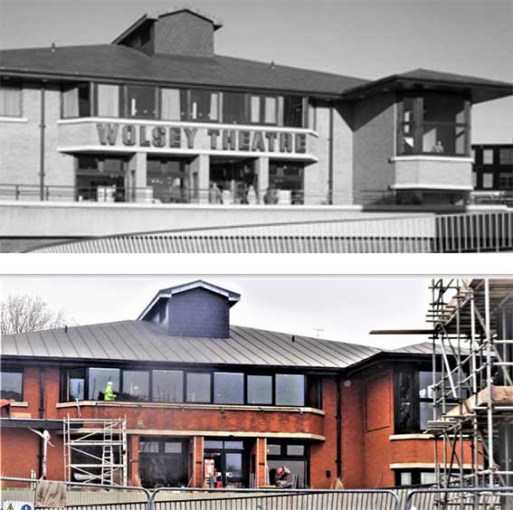 Comparison
images courtesy Tim Leggett
Comparison
images courtesy Tim Leggett
In 2001, the theatre reopened and is now owned and operated by the New Wolsey Theatre Company which is a registered charity with a stated mission of presenting high quality, diverse and accessible work, and operated on a not-for-profit basis.
 The
ghost sign, 2020
The
ghost sign, 2020
Above the staining on the brickwork left by the lettering 'WOLSEY THEATRE' which was here from 1979 for over twenty years – and still visible in 2020, as spotted by Tim.
 2021 images
By January 2021 the new lettering is in place. To the left in the upper image is the newly completed 'Golden Pavilion' housing New Wolsey 2.
1902 map
The 1902 map of this area shows a very different street layout to that we see today, as can be seen by overlaying the modern streets in pink, above. See also our page on Black Horse Lane.
The main changes in road routes from St Matthews Street down to Princes Street, turning left into the new dual carriageway of Cromwell Street. At this point, protesters halted the bulldozers which were about to push this new road through ancient buildings in St Nicholas Street, Silent Street, Lower Brook Street, Foundation Street and Fore Street. The last of these was, of course, eventually cut through by the Star Lane 'Eastern Gyratory' traffic system in the 1980s. Those protesters, concerned at the wholesale demolition of the architectural heritage of this ancient town, soon formed The Ipswich Society (see Links) in 1960. Many of the roads and buildings demolished were of poor, working class dwellings, run-down beer houses and old industrial buildings. The hill on which Civic Centre was built had been an area of the town called 'The Mount' and the lanes dropping south from St Matthews Street were Church Lane and Lady Lane. Below Handford Road and Mount Street (running east-west), Lady Lane led down to Tanners Lane which eventually joined Friars Bridge Road and Princes Street. See our Friars Bridge Road page for a 1902 map of the area. The new dual carriageway running from the southern end of Berners Street down to the Greyfriars site more or less followed the lines of Church Lane and Tanners Lane. It was called Civic Drive to reflect its proximity to the group of buildings around the new Civic Centre, law courts and police station block on Elm Street. The reshaping of this part of Ipswich was radical.
See also Lost Ipswich trade signs for Thomas Seckford's 'Great Place' in Westgate Street, destroyed during the cutting-through of Museum Street in the 1840s.
See our 'Ipswich Tomorrow' page for more about the Greyfriars and Willis developments, the Greyfriars timeline and a set of 1968 photographs of the newly built Civic Drive and Greyfriars area.
The little-noticed road signs on the brick central reservation on the upper part of Civic Drive are remarkable survivors of those early days. It is probable that their 'difficult' positioning and relatively small size accounts for their survival into the 21st century when so many other street nameplates have been replaced or updated.
2015 imagesTo the left of the sans serif, upper and lower case street name is the vestige of a coloured Ipswich coat of arms. Below that is a small piece of text (which someone has tried to obliterate with paint on the St Matthews end – now discolouring) which is more readable at the end close to St Matthews School:
'County Borough
of Ipswich'
This takes us back to a time when the county was split
administratively into East and West Suffolk and Ipswich County Borough.
Reorganisation in 1974 amalgamated east and west and removed many of
the powers and responsibilities of the Borough, concentrating many
finances and powers in a new Suffolk County Council. Another
view of a similar Civic Drive street nameplate from 1968 showing the
coat of arms appears on our Ipswich
tomorrow page.of Ipswich'
For more information and maps of the Willis Faber & Dumas building at the bottom of Civic Drive and its effect of the Greyfriars area, see the 'Before Willis' section of our Lost trade sign page.
Bernard Reynolds' Ship sculpture stands in the middle of the Handford Road roundabout on Civic Drive.
The Spiral Car Park
August 2021. Ed Broom, who has contributed several excellent lettering examples to this site, sent this: 'Looking down into the void of the Spiral car park I chanced across this splendid plaque on the left pillar of the entrance. Marjorie Keeble, the 4th woman Mayor of Ipswich, was apparently the first girlfriend of Sir John Mills!' Many thanks to Ed for recording this.
'COUNTY
BOROUGH
OF
IPSWICH
BOROUGH
OF
IPSWICH
THIS CAR PARK,
FOUNTAIN,
POOL AND TERRACES
WERE OPENED
BY
ALDERMAN MRS M.J. KEEBLE J.P.
THE WORSHIPFUL THE MAYOR
OF IPSWICH
ON
TUESDAY 25TH APRIL 1967'
POOL AND TERRACES
WERE OPENED
BY
ALDERMAN MRS M.J. KEEBLE J.P.
THE WORSHIPFUL THE MAYOR
OF IPSWICH
ON
TUESDAY 25TH APRIL 1967'
2022
image courtesy Ed BroomOne of the survivors from the 1960s radical reshaping of the area known as The Mount is a curious car park diving deep below 'Theatre Square'. The Spiral Car Park is described as being an Ipswich landmark – even though there really isn't anything to see in the townscape. Work to build the car park started around 1964 as an integral part of the vision of the town based around car ownership (which also informed the ill-fated Greyfriars shopping centre scheme nearby). Civic Drive was cut through to Princes Street and St Matthews Street was widened despite contractors hitting problems with water springs during excavation work. No doubt the deeper the sprial was excavated, the more water became a problem. This must have been a remarkably adventurous piece of civil engineering as it delves deep into the ground. A black striated structure still stands today at the centre of the spiral and it marks the top of car park's ventilation shaft. The Civic Centre fountain was switched off soon after the opening as car park visitors were often soaked on a windy day.
Constructed by this local sculptor, Bernard Reynolds. in 1971 the following year the Ship sculpture was originally sited at the foot of Civic Centre (now demolished) where it stood in a pool of water. Most people recall it sitting in a dry pool. In 1996 this sculpture was moved from its neglected position to the centre of the Civic Drive/Handford Road roundabout.
Chapman Lane
2015 imageJust off the northern stretch of Civic Drive, on the east side is Chapman Lane. It runs behind the Wolsey Theatre buildings and is mainly seen as a service road for deliveries to the rear of shops fronting the eastern section of St Matthews Street and for car parks to the north of the former Civic Centre site. However, it does have an interesting street name derivation. Interestingly, this part of the road is labelled Black Horse Lane on a 1994 street map of the town, so this must be a more recent naming.
Civic Drive (with central reservation) is in the background; this is a riot of street furniture: bus shelter, telephone kiosk, ramp handrails, street sign and, amongst the trees, parts of the Church of St Matthew.
The Wolsey Theatre
2019 imageAbove: the most recent incarnation of the New Wolsey Theatre. As part of the 2020 building of the 'Golden Pavillion' and refurbishment, the NWT sign was removed (see the comparison images below, courtesy of Tim Legget, to whom our thanks).
The theatre building was designed by Roderick Ham for Ipswich & Suffolk New Theatre Trust. Construction was carried out between 1977 and 1979 by Haymills Contractors Ltd with Carr And Angier theatre consultants providing planning advice and design/installation of all technical systems and equipment. From 1979 to 1999 the theatre was operated by The Wolsey Theatre Company, a regional repertory company. The theatre was known for showing performances of drama, comedy and musical plays and was used almost exclusively as a producing house. Due to financial problems dating back to the mid-1990s, the operating company closed the theatre in 1999 and was dissolved.
Comparison
images courtesy Tim LeggettIn 2001, the theatre reopened and is now owned and operated by the New Wolsey Theatre Company which is a registered charity with a stated mission of presenting high quality, diverse and accessible work, and operated on a not-for-profit basis.
The
ghost sign, 2020Above the staining on the brickwork left by the lettering 'WOLSEY THEATRE' which was here from 1979 for over twenty years – and still visible in 2020, as spotted by Tim.
2021 imagesBy January 2021 the new lettering is in place. To the left in the upper image is the newly completed 'Golden Pavilion' housing New Wolsey 2.
Search Ipswich
Historic Lettering
©2004 Copyright throughout the Ipswich Historic Lettering site: Borin Van Loon
No reproduction of text or images without express written permission
©2004 Copyright throughout the Ipswich Historic Lettering site: Borin Van Loon
No reproduction of text or images without express written permission