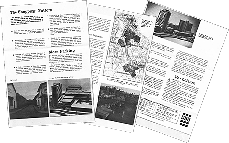
This short leaflet, from the
collection of Ipswich Society member Trevor Hart, was produced by the
developer of what was
then seen as the utopian Greyfriars complex (1964-66) until the
Government abandoned the planned expansion of the whole area.
Hindsight, of course, is a wonderful thing, but the language used and
attitudes expressed in the document are very striking. They ring very
hollow over the decades and evoke an early 1960s struggling to leave
the grey austerity of post-War Britain and fling itself towards the
white heat of technology proclaimed in 1963 by Prime Minister Harold
Wilson.
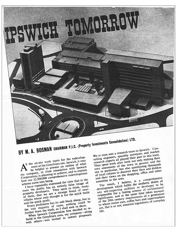
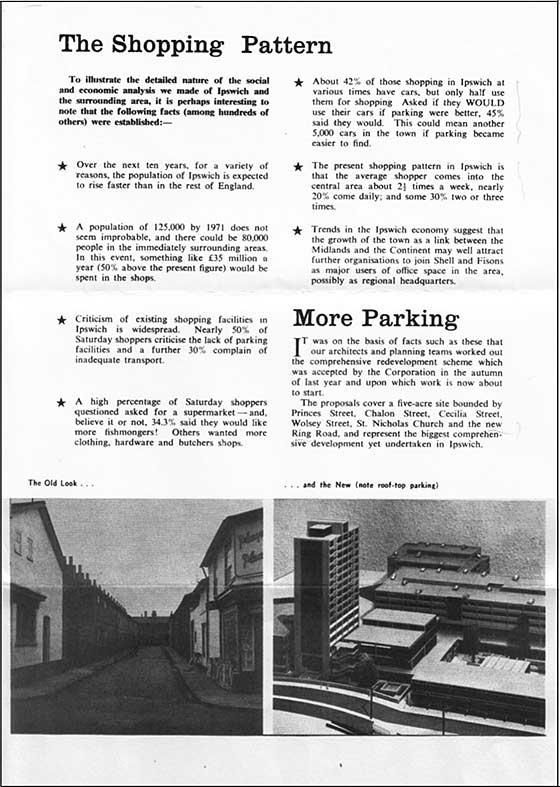
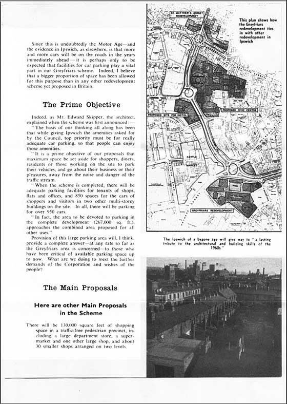
Two photographs are juxtaposed captioned 'The Old Look...': a street of Victorian terraced housing with corner shop in the foreground - 'Players Please' above the door and newspaper headline boards below the shop window; '... and the New (note roof-top parking)': an architect's scale model of the Greyfriars development with tiny cars visible on the top deck. A major feature of the project, we are told, is greatly increased parking for cars which will attract pleasure-seekers, shoppers and diners to the town to spend money and appeal to "further organisations to join Shell and Fisons as major users of office space in the area, possibly as regional headquarters." Most ironic of all is the caption above an elevated view of terraces, two churches (probably St Nicholas and St Peter) and the distant dockside silos: 'The Ipswich of a bygone age will give way to "a lasting tribute to the architectural and building skills of the 1960s".'
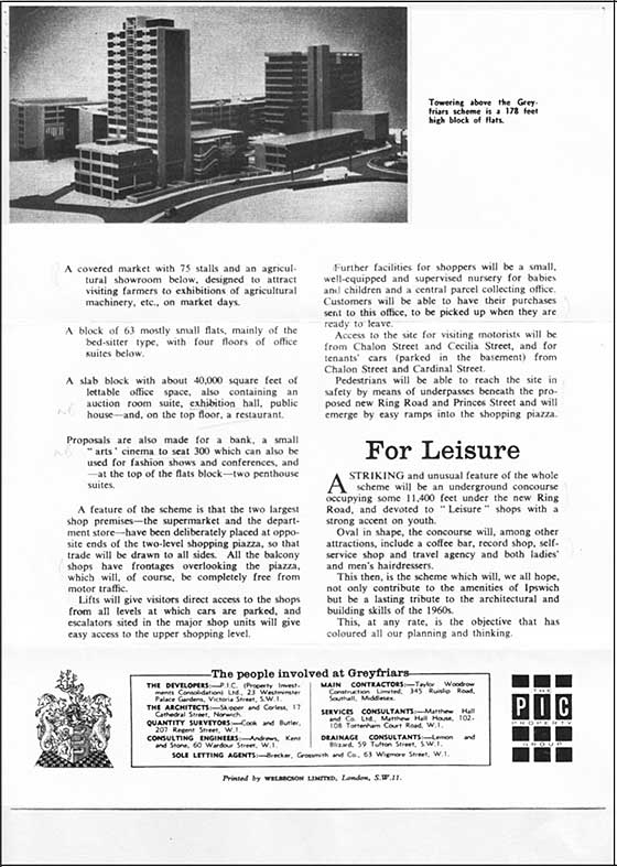
Some of the attractions planned for the complex (apart from the copious parking) are 'a large department store, a supermarket [Pricerite and their S&H pink stamps] and one other large shop, and about 30 smaller shops arranged on two levels, a covered market with 75 stalls and an agricultural showroom below, designed to attract visiting farmers to exhibitions of agricultural machinery etc. on market days... an auction room suite, exhibition hall, public house - and, on the top floor, a restaurant. Proposals are also made for a bank [there was a branch of Midland bank], a small "arts" cinema to seat 300 which can also be used for fashion shows and conferences... a coffee bar, a record shop [remember them?], self-service shop and travel agency and both ladies' and men's hairdressers.'
In reality, what ensued in the tortured history of the development will be well-remembered by many Ipswichians:
- the Pricerite supermarket, giving S&H Pink Stamps with your shopping, which hung on for a few years;
- the travelator (moving pavement) which ceased moving;
- the ramp entrance to the multi-storey car park in New Cardinal Street which hardly seemed wide enough for any car climbing up it between those dangerous-looking concrete edges and tight bends;
- the wood-grain texture on the poured concrete walls formed by the timber shuttering used, and left as a 'natural-looking' finish.
 Photograph courtesy The Ipswich Society
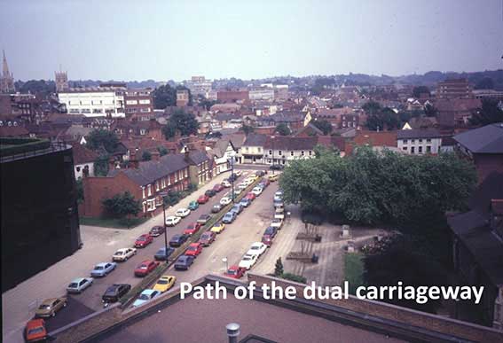
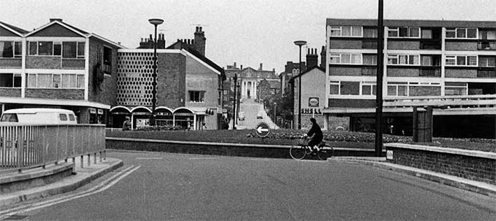
Cromwell Street, north side, early 1970s. The dual carriageway comes to a juddering halt at the mid-right of this photograph, with the rather good row of 17th century shops on St Nicholas Street facing the driver. At the left, the demolition of houses prior to the building of the Willis building has begun; the gap with the low board barrier used to be the junction with Friars Road. These rather nice Victorian houses had looked out on a similar terrace on the opposite side of the road. All were built by the Freehold Land Society. Dualling of the road resulted in the demolition of the latter, so the view would have included St Nicholas Church. St Nicholas Church Lane also disappeared; see the 1902 map in the 'Before Willis' and 'After Willis' sections on the following link.
See also Lost Ipswich trade signs for sections on 'Before Willis' and 'After Willis' and an note about Thomas Seckford's 'Great Place' in Westgate Street, destroyed during the cutting-through of Museum Street in the 1840s.
See our FLS page for photographs of one of the surviving houses on the former Cromwell Street, 'Honiton House'.
See our Prince Obolensky page for views of the current Cromwell Square.
One additional footnote: the threat of further demolition of historic buildings from the east side of St Nicholas Street onwards provoked an outcry from Ipswich residents and others who eventually banded together to form The Ipswich Society in 1961. This Civic Society spoke out in favour of preserving and using the historic buildings which still remained intact. The Society still fights for the good of the town in future developments, promoting conservation and quality design and build.
This segment is based on an article from The Ipswich Society Newsletter, April 2016, Issue 203 (see Links); it gives an excellent overview of how the roads and streets in this part of Ipswich were under threat.
The Ring-Road that never was
Just imagine a government deciding that a town's population should double; the town preparing for such an influx of population by demolishing, reconstructing, providing new infrastructure and the means by which a large new population could be absorbed into the framework of a town.
Imagine the building of the new roads including Civic Drive; the construction of a new shopping centre, Greyfriars; the preparation for further expansion, all being undertaken with the vigour and the enthusiasm that the prospects of increased population can bring to a town – even a ring-road eventually to encircle the town centre as a dual carriageway.
Imagine the first phase, well underway: roads constructed, preparations for further stages including the demolition of buildings along planned routes for extensions of roads; the concerns and worries of local people and interested parties in the history and archaeology of that place swept aside by a great plan for the future success of the town. Imagine all this only to find that the government has changed its mind. The London overspill programme hadn’t been a roaring success. Evidence was to be found in Haverhill, Thetford and Great Cornard; so, a new town was developed, Milton Keynes. Ipswich was no longer to double its population. Ipswich was to get nobody at all.
Photographs from the Ipswich Society’s Image Archive (see Links).
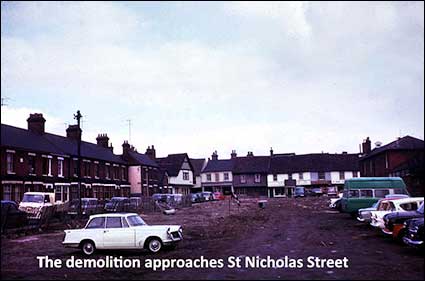
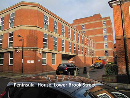
The construction of the planned ring-road came to a halt. People were listened to, the worry about the destruction the road would cause to the town's ancient fabric was heard and, anyway, the pressure was off Ipswich. However, work had already started to clear the route for the next phase: Richard Felaw’s house in Foundation Street had been demolished and the remnants of Blackfriars monastery were threatened. Today we can see Peninsular House at 11-13 Lower Orwell Street, carefully chamfered to fit a roundabout and the nearby multi-story car park in Foundation Street proudly stands on the site of [Richard] Felaw’s house which had originally been cleared for the new road. Then there is today’s Cromwell Square: this car park is formed from the last section of the dual carriageway to be built which ended at St Nicholas Street.
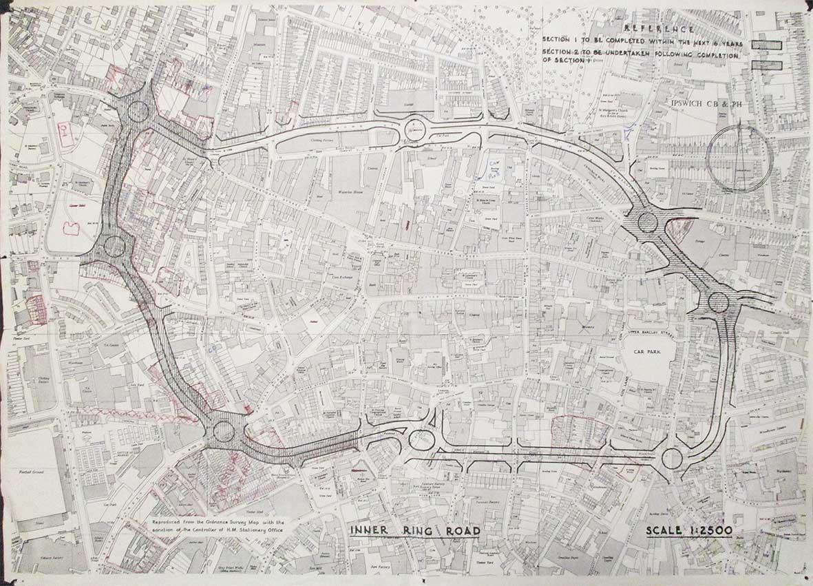
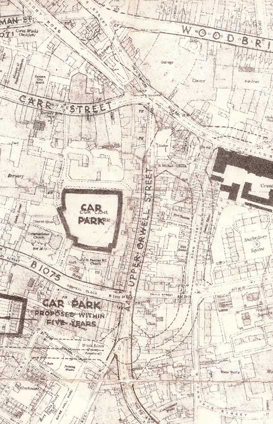
[UPDATE 30.9.2024] Overall 1958 Ring-road plan
The map of Ipswich town centre shown below is from Nick Wiggin's collection, to whom our thanks. It is the only source we know which shows the whole planned scheme.
Points of interest
1. The hatched section to the east indicates the section of dual carriageway with its three roundabouts (from St Matthews Street down to Cromwell Street) which was actually built. Note that the easternmost section of Crown Street from St Georges Street to Crown Street junctions was eventually dualled – although without the raised central reservation.
2. The section with horizontal hatching to the east (St Helens Street to Woodbridge Road junctions) was definitely not built.
3. The annotations in red pen to the south-east label the 'Greyfriars Scheme' with nearby Friars Bridge Road deleted with a series of Xs. A major area of demolition is shown hatched in red around and between the St Matthews roundabout south to the Handford Road roundabout. Tanners Lane (parallel with Curriers Lane) has disappeared under the lower section of Civic Drive.
4. The last, southernmost section of the dual carriageway moves towards the east causing the demolition of the southern rown of houses on Cromwell Street, also the tiny St Nicholas Church Lane. The large monochrome photograph shown above proves that the raised central reservation with its grassed top was built up to St Nicholas Street. It was eventually removed all the way up to Franciscan Way. In recent years, of course, the Prices Street roundabout itself was removed.
 1958
map
1958
mapMap detail (1)
 1958
map proposal
1958
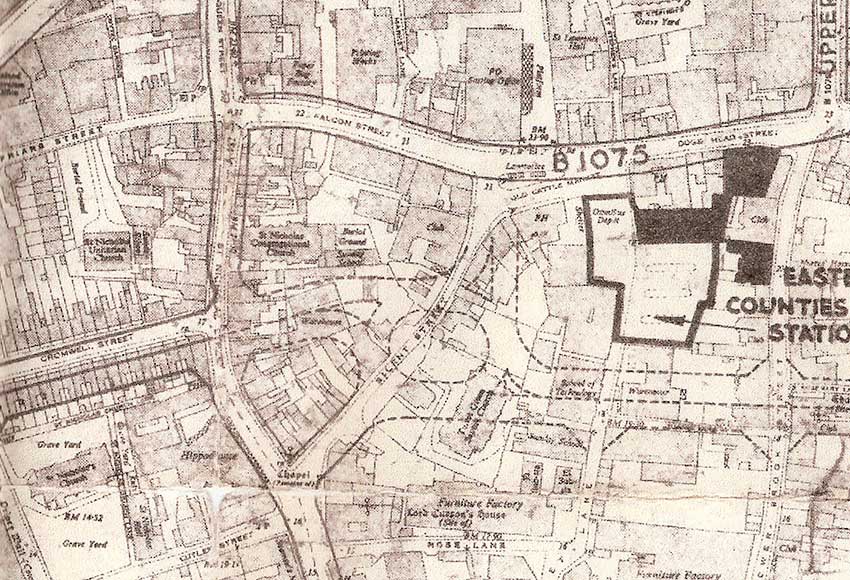
map proposalAbove: detail of another 1958 map of the southern area of central Ipswich with the proposed ring-road shown in broken lines. The dual carriageway built down as far as the eastern end of Crowell Street would have pushed through St Nicholas Street buildings with a large roundabout covering most of Silent Street; it would then have moved eastwards over Turret Lane and Lower Brook Street towards Foundation Street and beside the site of today's multi-storey car park. Note the legend on the 1958 map above Rose Lane: 'Furniture Factory; Lord Curson's House (Site of)', which doesn't quite fit with the location shown on our Wolsey's College page.
For Ipswich during the 1960s there was no question that some improvements were needed. A traditional but booming market town where the livestock market was still operational, farmers and rural Suffolk people came into town regularly. There were great local shops: Ridley’s, Footman’s, Cowell’s Department Store in the Butter Market and Sneezum's as well as many successful manufactories.
But there was a demand for new roads as the numbers of commuters and traffic coming into town grew. A wave of prosperity was flowing over Britain and over the town, people wanted better, newer things, so this was reflected in the aspirations of central government and local government too. If we look at a current street map of Ipswich it is possible to see the sweep of Civic Drive from St Matthews Street down to Saint Nicholas Church. This is the remains of the ring-road plan and the vestiges of the last stretch heads eastwards through Cromwell Square car park.
 Photographs by Tony Marsden
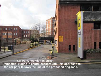
Had the plans come to fruition the ring-road would have destroyed the jettied, timber-framed, 17th century buildings around 25-29 St Nicholas Street, putting a large roundabout over Silent Street, striding through Turret Lane, Lower Brook Street, Foundation Street, and Upper Orwell Street (see the map detail below). Just imagine a government deciding that a town's population should double; the town preparing for such an influx of population by demolishing, reconstructing, providing new infrastructure and the means by which a large new population could be absorbed into the framework of a town.
Map detail (2)
 1958 map proposal
The ring-road then looped northwards to flatten and broaden a dualled Bond Street, meeting St Helen’s Street at a large roundabout just outside the Regent Theatre, always supposing the theatre had been spared. From here traffic would head westwards to the Robert Ransome [Tower Ramparts]. Old Foundry Road and St Margaret's Street would now surround an island on which all the buildings in the middle would remain. A dual carriageway would sweep across the bus station to a roundabout at the top of Lloyds Avenue, in front of Crown Pools. At this point the traffic would continue straight along Crown Street, St Matthews Street (sections of which are still dualled today) and so complete the circuit at the top of Civic Drive.
Members of the Executive Committee were reminded of this last autumn when a map was handed over to us. It was dated 24th April 1958, produced on behalf of the Borough Engineer and Surveyor John B. Storey; it graphically outlined the plans for the town to be radically changed. It had been produced in response to government plans and measures to create an ‘Ipswich New Town’ scheduled to get a mass of London overspill in the 1960/70s which would double the population of the town.
When we examined the map there was no big surprise because much of what the it indicated had been known in the intervening years and we were aware of the narrow escape that the town had experienced; the striking thing was the detail and scale of what had been planned in such simple graphic form. Moreover, at the behest of the central government of the time there seemed to be a complacent ease with which the lines were drawn paying little attention to the potential destruction of parts of our historic town. But some of us were reminded of another occasion, when there was not an escape but an opportunity missed – the effect being that of shock.
In December 2007 the planned Unitary Authority for Ipswich was deemed by the Secretary of State, Hazel Blears, to be unaffordable: "Politicians in Ipswich today reacted with shock and dismay after proposals for home rule were controversially shelved amid claims it would prove too expensive" said the local press. One councillor at Ipswich Borough, Lib Dem leader Andrew Cann, said he found the decision to abandon unitary status for Ipswich “inexplicable”.
It was a move that rendered hundreds of hours of officer time and thousands of pounds of taxpayers' money wasted: central government announced that Ipswich's unitary bid would not get the green light. The then Department for Communities and Local Government told the town that Ipswich had not met “the affordability criteria”.
There seems, on occasion, to be an apparent arbitrary nature to governance witnessed by people who are unaware of the full story, or who have the full picture obscured from them. The question often asked is: ‘Who makes judgments and who decides?’. In the cases here mentioned the central government of the time takes responsibility and we at the local level can only react and respond accordingly. The map is interesting and provocative especially at a time when devolution for Suffolk, Norfolk & Cambridge seems to be imminent and Suffolk Coastal & Waveney are looking to merge. On this occasion the government has distanced itself from the decisions – it is a local matter, the responsibility will not rest with Whitehall. I wonder whether in fifty-odd years time there will be a map to contemplate which our successors will find reflects an escape or a shock – and who then will be there to take responsibility?
Tony Marsden (including contributions from John Norman and Mike Cook)
[UPDATE 14.3.2017: 'Reminds me of the song, They Paved Paradise and Put Up a Parking Lot*. A lot of history gone. Thank goodness they stopped before it was all gone. Regards, Carolyn Saxon']
*©Joni Mitchell
Greyfriars timeline
1958: Dated map of the proposed new Ring-road, samples of which are shown above.
1963: Vision for new centre revealed, planning permission obtained.
1964: Demolition of small streets begins ready for construction work.
1965-68: Construction work on site, includes creation of Civic Drive/Princes Street roundabout with restaurant/nightclub in the centre.
1967: Farmland in Bucks is designated an official new town, eventually resulting in Milton Keynes.
1969/70: Greyfriars Centre fitted out and first occupants move in, including the market and Pricerite supermarket.
Early 1970s: Market moves out after people fail to use it.
Mid 1970s: Restaurant/nightclub changes hands several times, but eventually closes.
Late 70s: The Centre's shops are largely unoccupied (including Pricerite), although the offices at St Clare House and the flats at Franciscan Tower (Now Ipswich Central tower) remain occupied.
1982: Willis takes over the site, and plans to turn the multi-storey into a staff car park and demolish the old shops and central area.
1984: Shops and plaza are demolished, replaced by grassed area.
Late 80s: St Clare House is reclad to make it more attractive.
1990s: Franciscan Tower is reclad and renamed.
2012/13: Civic Drive/Princes Street roundabout removed and replaced by a junction with traffic lights, empowering pedestrains and cyclists and annoying some motorists.
Civic Centre
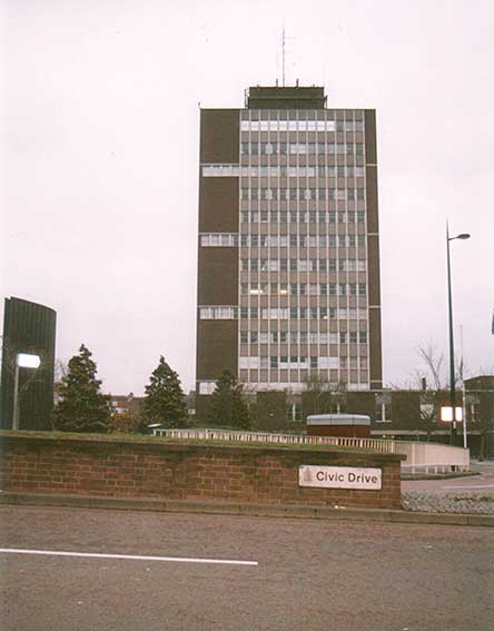 Pre-2008 photograph courtesy John
Norman
Pre-2008 photograph courtesy John
NormanAbove: a view of Civic Centre when it was still in use (pre-2008). The entry to the Spiral car park can be seen at lower right. The Spiral, which remains in operation, has room for more than 300 cars. When it was constructed, nearly 60,000 tonnes of earth had to be removed.The architects of Civic Centre were Vine & Vine, and it was built in 1963 – this was the first tower block in East Anglia. Many old terraced homes were demolished to make way for the new buildings such as Castle Street, Perth Street and Stirling Street. It was the Borough Council’s headquarters (moved from the Town Hall on Cornhill). It comprised 14 storeys above ground with a two storey underground basement. There was a four- and two-storey annexe on either side of the main block, with a ground floor car park to one side. The building was demolished between July 2008 and March 2009 due to 'concrete cancer' – the rusting of reinforcement bars in the concrete causing structural damage. The same problem affected Civic College, later Suffolk College, on Rope Walk/Grimwade Street.
Ipswich alterations 1968
[UPDATE 18.1.2019: 'Hi Borin. Thought you would like to see, use the attached photos. They where found while sorting through my Grandfather's effects. Labelled up "Ipswich Alterations 1968". His name was Arthur E. Featherstone. Regards, Paul Smith. Many thanks to Paul for these, presumably unseen photographs, captions/comments are by this website.']
 1968
images courtesy Paul Smith
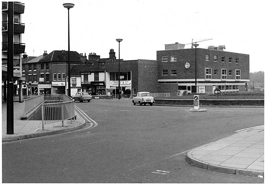
1968
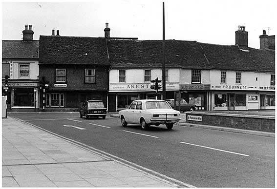
images courtesy Paul SmithAbove: St Matthews Street and roundabout from the bottom of Berners Street. The three St Matthews Street shops with hipped roofs appearing from the left still exist unchanged. The mixture of old and new buildings up to The Victoria public house (which also traded as The Queen's Head) at the right have radically changed. It is notable that several of these buildings appear to be vacant in 1968. The future pub, with its royal-looking bust, sited high up – still there today, is being fitted out. Two businesses seem to be trading: Stratfords travel agent ('Railway Ticket Agency') and next door's C.C. Barker. The Victoria public house, licensed from 1967, was built more-or-less (but pushed south) on the site of the earlier Queen's Head (opened 1703, closed 1963) which stood on the corner of St Matthews Church Lane and was demolished during the major upheavals here. See our Wiggin & Son page for an Edwardian photograph of The Queen's Head.
Here is a photograph which pre-dates this set and which shows The Queen's Head Hotel in March 1964:
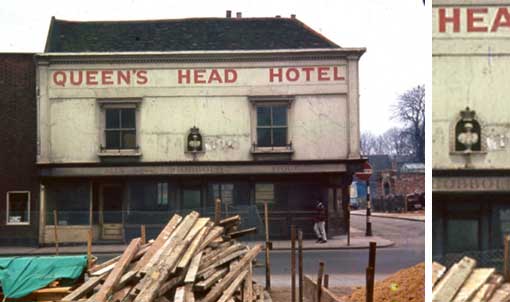 1964
image
1964
imageAbove: The Queen's Head Hotel at the corner of St Matthews Street and St Matthews Church Lane; clearance for the building of Civic Drive and the roundabout is progressing. The Suffolk CAMRA website (see Links) dates The Queen's Head back to 1703; it closed December 31 1963. Photograph by Alan Valentine. Was the bust of the queen in the centre of the building saved and rebuilt into the new block? The surround with the crown is different, but the bust looks the same. [Source: EADT 24 September 2015 - Kindred spirits]
The brutalist block at the extreme left of the first 1968 photograph still has its colonnade, but the upper stories succumbed to 'concrete cancer' (rusting of the metal reinforcing rods) and were demolished and the flat space is now a car park accessed from Bedford Street. The entry where the photographer is standing is the access to the rear of the parade of shops and today's BBC Suffolk studios. A tall construction crane visible behind the Victoria indicates that construction is continuing on the Guardian Royal Exchange site further down Civic Drive.
 Close-up
view
Close-up
viewAbove: in 1968 photographer Arthur Featherstone was able to stand in the middle of the northbound carriageway of Civic Drive to take this photograph, the only traffic visible comprises a van and cyclist on St Matthews roundabout. Clearly he wanted to get an uninterrupted view of Berners Street with the famous portico of Anglesea Road Hospital at the top. After the hospitals were amalgamated on the Heath Road site in the 1980s, this eventually became 'Anglesea Heights', a nursing home run by BUPA, however, this closed and at the time of writing (2019) the local press reported 'Ipswich School swoops on Anglesea Heights'. The 'SHELL' sign just above the cyclist's head indicates that there was a filling station here at this time. This space between the shop and the hotel is currently used for car parking.
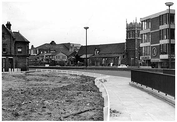
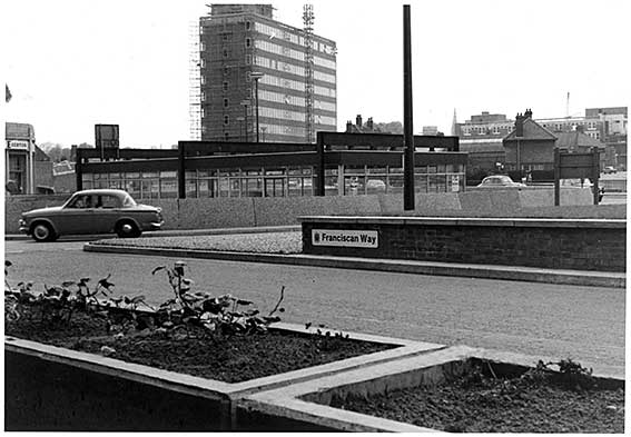
Above: Franciscan Way with the Church of St Nicholas between the new Midland Bank block and rising behind low buildings the roof of the Ipswich Hippodrome, which was a bigger venue than the Regent on Majors Corner. The theatre opened in March 1905 and was demolished in 1985 and has the distinction of being built on the site of the home of the most famous son of Ipswich, Thomas Wolsey (hence today's Cardinal House which replaced it). The rough soil plot at the left is the future site of the Willis building (see our Lost trade signs page for 'Before Willis').
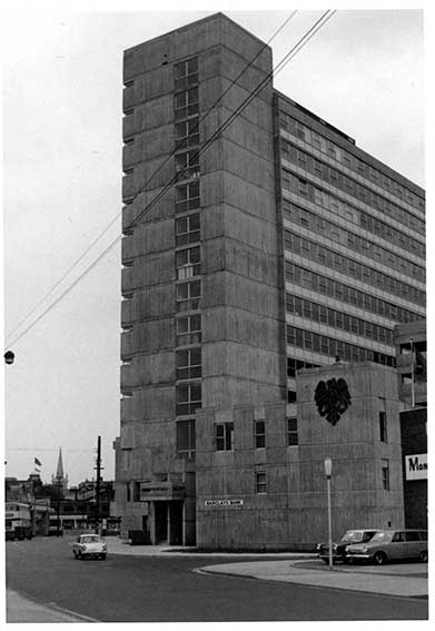
Above: St Clare House with the low-rise 'BARCLAYS BANK' with its spread eagle logo (the latter has been demolished). The pour of the concrete into timber moulds resulted in impressions of wood grain in the fabric of the building. It was thought at the time that this was a novelty to be left as it was. However, the concrete weathered badly and the block was a sorry sight. It has been reclad in black and is the home of Her Majesty's Revenue & Customs. The entrance between the bank and Mann Egerton's is Chalon Street which led to the concrete multi-storey car park behind the Greyfriars development (just visible behind). What would the Franciscan residents of the Greyfriars Friary which once stood on this site have made of this?
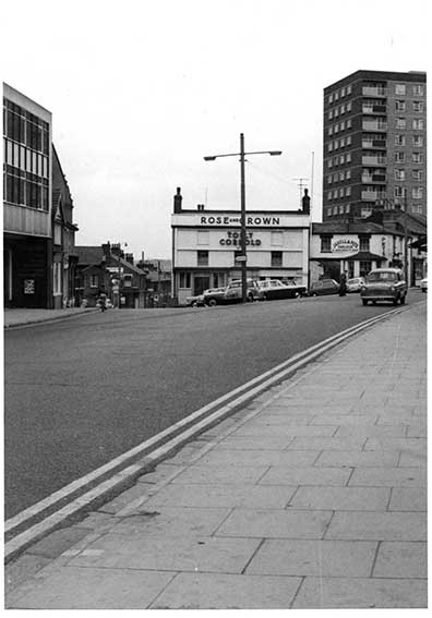
Above: Norwich Road at the junction with Bramford Road. The Rose & Crown was a landmark public house on the corner with a small triangular car park in front. Cumberland Towers is at the right. Much of the pub fell down/was demolished due to internal weakening of the structure in 2018.
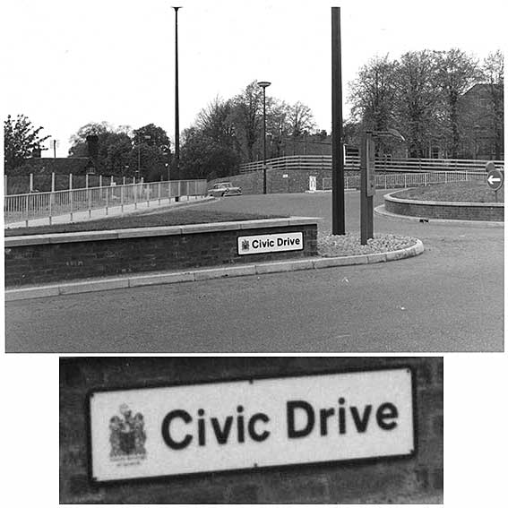
Above: the view is taken from outside the courthouse looking towards the entry to Handford Road with St Matthews Primary School behind the trees to the right. The roundabout eventually became the home of Bernard Reynolds' sculpture Ship. The street nameplate for Civic Drive clearly shows the Borough coat of arms with 'County Borough of Ipswich' beneath it – things changed radically in the 1974 local government reorganisation and Ipswich lost many of its powers and responsibilities to the newly-formed Suffolk County Council.
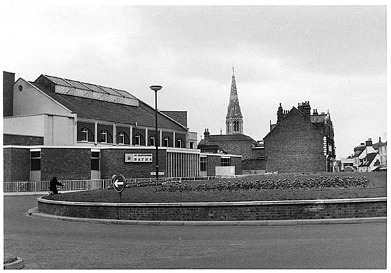
Above: St Matthews roundabout facing west. The main swimming baths of Ipswich, St Matthews Baths are at the left. The baths were boarded over to create the Baths Hall venue where Led Zeppelin played an early concert. Crown Pools on Crown Street replaced the baths as the town's main swimming pool in the 1980s (see also Fore Street Baths). The spire of the English Presbyterian Church, now Ipswich International Church, on the junction of the upper section of Portman Road and Burlington Road rises behind.
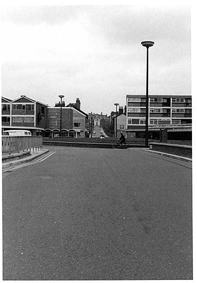
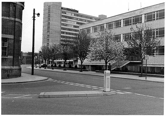
Above: The eastern end of Franciscan Way followed the line of the Victorian Cromwell Street; the terraced houses on the south side (the St Nicholas Church side) were demolished to accomodate a dual carriageway (see The Ring-Road that never was, above). This road is now the Cromwell Square car park. The row of 17th century buildings directly ahead of the cars was rescued from demolition, largely through the good offices of The Ipswich Society.
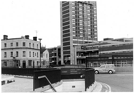
Above: the public house The British Lion is the three storey white building at the left (on the corner of Princes Street), displaying a stone lion at roof level. This disappeared with the 1975 Willis development. Behind the pub is the new 16-storey residential tower block, the Midland Bank branch in the smaller St Nicholas House and, just visible, the upper tower of St Nicholas Church.
Above: the view across the Princes Street roundabout, the view up Civic Drive is obscured by the curious building in the middle of the roundabout: once Tracy's, later Bogart's night club. The first Guardian Royal Exchange block is nearing completion, note the construction crane and scaffolding still in place. To the right of the street lamp post is the square tower of Church of St Matthew and the spire of the English Presbyterian Church, now Ipswich International Church, on the junction of the upper section of Portman Road and Burlington Road. The next block visible to the right is the Elm Street Police Station, opened in July 1968 (moving from under the Town Hall as shown on our Cornhill 2 page) and demolished in the summer of 2015. The end house of Curriers Lane is next.
[UPDATE 3.7.2023: 'First of all, what a fascinating website – Ipswich-lettering.co.uk. I was born in Ipswich in the early 1950s and remember much about it as it was in the 1960/70s. The above picture of Franciscan Way, the strange structure in the middle of the roundabout was never Tracy’s nightclub. Tracys was roughly behind where the picture was taken, within Greyfriars. You entered it after ascending the infamous non-moving travelator on the first floor. The structure in the middle of the roundabout was the “Merlin" Chinese restaurant - certainly in 1971. David Howlett.' Thanks to David for the contribution – and that below]
With regard to the Ipswich Tomorrow page
Above: Princes Street from the jaws of Portman Road. At the immediate left is the building once part of the Churchman's cigarette factory. In more recent years it was home to Community Service Volunteers (now Volunteering Matters) and Ipswich Community Radio; most recently it is the offices of Archant local newspapers. Across to road is St Clare House tower block (part of the Greyfriars development). The next plot to the right is, in 2019, the new offices of Birketts Solicitors and the block at the right still stands, but the entrance has been remodelled. This junction was the site of the last stone horse trough in Ipswich (removed in the 1940s? – need to check).
[UPDATE 3.7.2023: 'The above picture of the building on the right in Princes Street (with the clock above the entrance) was built in 1964 for the Shell-Mex & BP oil company and was their Eastern regional headquarters (my father was the chauffeur to the General Manager). They moved there from their previous building at 33 Lloyds Avenue (which is now a solicitors). Unfortunately they had a reorganisation in 1966 and closed it down. Afterwards it was used by British Telecom (BT). David Howlett.']
See our Friars Bridge Road page for an early 19th century illustration of the ruins of Greyfriars priory.
See also our Lost trade signs page for a feature on 'Before & after Willis'.
Please email any comments and contributions by clicking here.
Search Ipswich Historic Lettering
©2004 Copyright
throughout the Ipswich
Historic Lettering website: Borin Van Loon
No reproduction of text or images without express written permission
No reproduction of text or images without express written permission