'Shire Hall School'
Smart Street, Pleasant Row, Lower Orwell Street
Next to Thomas Rush
and Henry Tooley, William Smart is
one of the best known merchants of early Tudor Ipswich. He is
better known for being the founder of the library in Ipswich. However,
he has also made great contributions to the Tooley
Almshouses by expanding the structure. So, there is also an
inscription dedicated to Smart with following text: “Let gentle
Smart sleep on in pious trust - Behold his charity, respect his
dust”. Smart Street also comemorates this powerful and charitable
man. 2013 images
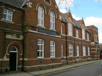
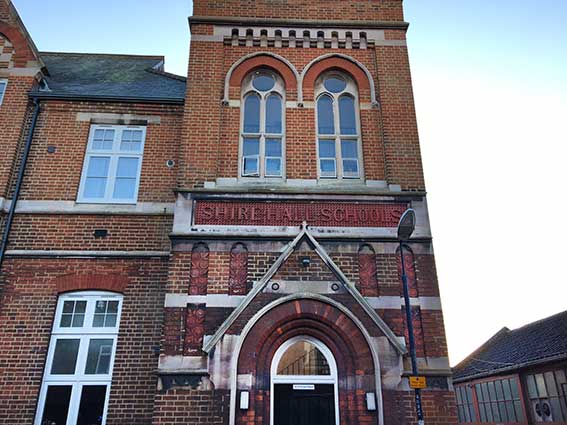
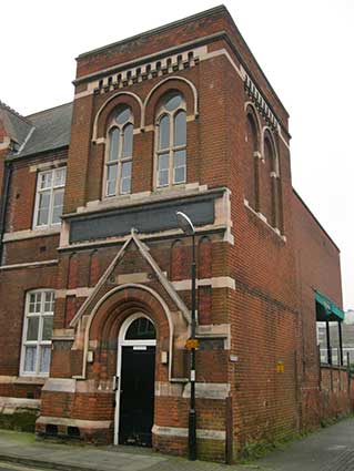
Here's a corner of Ipswich, once a large school built
in 1883, then
an Art School annexe
of Suffolk College, later the scene of an exhibition as part of the
'Art
Centre For Ipswich' campaign. Now the playground at the rear of the
building
has been redeveloped in a sympathetic style and the whole complex is
residential.
All the signs on this elevation are obliterated or covered with blue
boards
which once carried the Suffolk College lettering. Beneath, we believe,
are the terra cotta signs of the original building: possibly 'IPSWICH
BOARD SCHOOL' and 'SMART STREET SCHOOL' (see Bramford
Road School for a likely template). We have so far failed to find
early photographs of this school to confirm this. The blue board at the
end is splitting and may eventually drop off enabling us to see what
lies beneath.
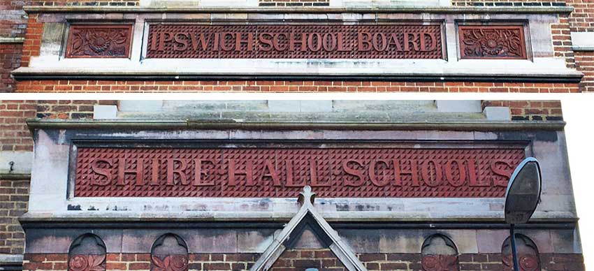
[UPDATE 4.1.2021: 'Borin,
you
might find these useful. When you last put up pictures of Smart St
School the words were covered with blue boards. Those have now gone
revealing the texts beneath. Use the photos if you wish. Owen
Thurtle.' Many thanks to Owen for
spotting and recording this, particularly because the removal reveals a
surprise. See below.] 2021 images
courtesy Owen Thurtle
Above: the corner of Smart Street and Pleasant Row after the boards had
been removed.
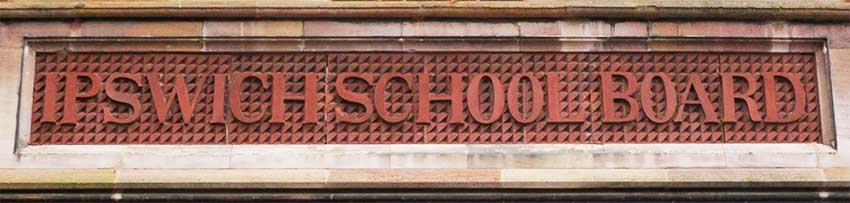
'IPSWICH
SCHOOL
BOARD'
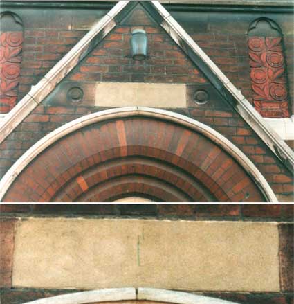
'SHIRE .
HALL .
SCHOOLS'
Et voila! We had no idea that the
building we referred to for years as 'Smart Street School' or 'Smart
Street Annexe' was originally called Shire Hall Schools – presumably
because of the separated boys, girls and mixed infants. It is, as we
can see on the 1902 map below, referred to only as 'School'.
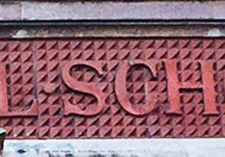
The detail below shows the serif'd capitals standing out against a very
busy 'faceted square' tessellated background. The nearest comparator in
the town is Bramford Road School (shown on our More schools page) where there is a
diamond-shaped tessellation. That school also has an 'Ipswich School Board' sign. The close-up below
shows the detail of the character 'S' and the way in which these three
words are separated by the equivalent of a decimal point – a device
seen on other signs. Between the 'L' and the decimal point, it looks as
if there is a vertical join between panels of the sign.
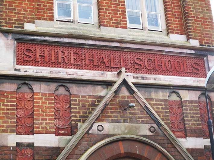
Below: the 'Shire Hall Schools' lettering without the intrusive street
lamp. Also, on this wet January 2021 day, the obscured 'Boys' sign is
readable above the doorway arch. 2021 images
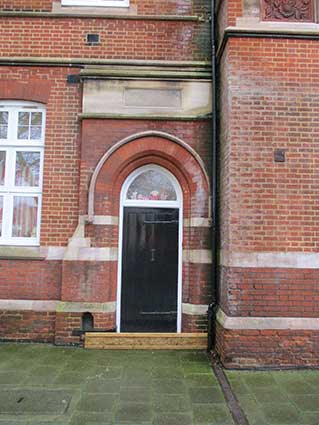
These quite grand entrances
once admitted the segregated
boys and girls, away from the infants round the corner. Looking
carefully at the right hand side entrance,
you can just make out the 'medieval'-style lettering as used on the Public
Library entrance in Northgate Street, which has been in-filled with
mortar: 'BOYS'. The close-up
shows
it a little better. Often the dampness in the air can affect the
readability of such 'hidden lettering'. 2004 image
The detailing in the terra cotta panels is worthy of
note, with the dust and grime in the sunflower design enhancing the
detail: 2017 images The square tower at the far right of the school contains the
obscured 'BOYS' tablet as well as some fine stylised flowers and leaves
growing out of an urn.
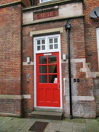
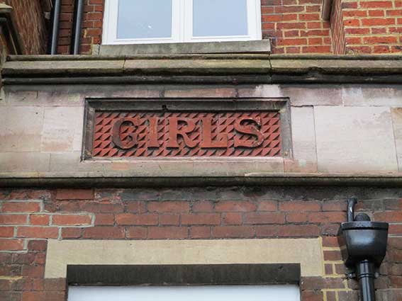
Below: a more fugitive 'GIRLS'
tablet may be present above the left hand side entrance
further
down Smart Street. The
larger 'Girls' entrance
in Pleasant Row had the covering boards removed
at the same time as those shown above (scroll down).
Note also that the 'Infants' sign in simlar style is round the corner
in
Pleasant Row; it was never covered up. It is shown below.
2013 images
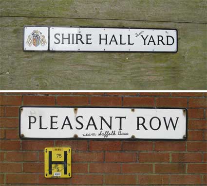
These street signs placed close together are relatively recent:
the upper one, which is attached to the shuttering barrier around the
old Gym & Trim site, showing the Borough
coat of arms.
Shire Hall Yard
The location is quite historic, but the empty, concrete hulk of the
former Gym & Trim business and its car park mark years of blight
and neglect. Smart Street leads round to Shire Hall Yard, really a
short street, which leads up behind the Tooley Almshouses end wall to
Blackfriars Court. The Shire Hall, a
large and nearly square brick
building erected in 1699 by voluntary subscription, once stood on the
G&T site. It acted as a courthouse with two distinct courtrooms and
a room for the Grand Jury. Around the side of Smart Street School is
Pleasant Row which originally
may have been one of several narrow lanes running from the old town
towards the Wet Dock. By the 19th century it was a narrow passage
running from the Shire Hall Yard 'by a little gate at the south-east
corner' to Star Lane (opened up in the 1980s and destroying many old
lanes and buildings) where it is thought the old Drapers' Hall once
stood. Images of Shire Hall The drawing above right is signed 'Slader Hoare'. A map of this area from the 1880s can be found on our page about
Courts and Yards.
An even older map, Pennington's
map of 1778, shown on the Courts and Yards page clearly
shows the Shire Hall with Foundation Street sloping to its left and,
parallel to it, 'The Lower Wash', now known as Lower Brook Street.
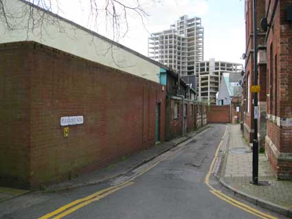
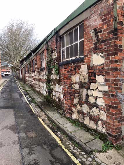
Pleasant Row
The ironically named 'Pleasant Row' runs down the side of the old
school. The 'Wine Rack' skeletal structure, an abandoned segment of the
Waterfront Regeneration since the financial crash of 2008, in the
distance.
Since the building of the
'Eastern Gyratory'
traffic system, a brick wall blocks the old street. 2013 images
Walking down Pleasant Row, the first school entrance
with a board covering the lettering (perhaps 'GIRLS'?) is almost as it
was when the place was noisy with children's voices and bustle. It is
as if they have just left after a normal schoolday.
[UPDATE 4.1.2021: At the
same time that the boards were removed from the Smart Street elevation,
this entrance revealed itself to be that dedicated for 'GIRLS'. 2021 images
A little further down, we discover one
architectural piece of school lettering
which had not been covered by a blue board: 'INFANTS' in terra cotta
serif
caps against a geometric design, with the school door intact below it.
In
the background is the sympathetic new residential development.
The Borough's local list tells us:
"10-18 Smart Street, former Smart Street School. (1881-82) Architect:
Brightwen Binyon. Board school. L-plan storey group at the corner of
Smart Street and Pleasant Row. Red brick, Ancaster stone dressings,
terracotta panels, slate roof. Varied street elevations with projecting
gabled bays, the north west entrance bay with a straight parapet and
ornamental stone machicolation course. Segmental arched window openings
at ground floor level, recessed arched doorways with stone hood moulds.
Above, a double stone string course framing stone fascias (now partly
covered by timber panels). At first floor level, tall paired gothic
windows with hood moulds, the north west group with stone plate
tracery. Ornamental terracotta panels. The recessed bays have smaller
gables containing blank arches with brick and stone chequerboard
patterns in the spandrels. Traceried roundels to gables facing both
Smart Street and Pleasant Row."
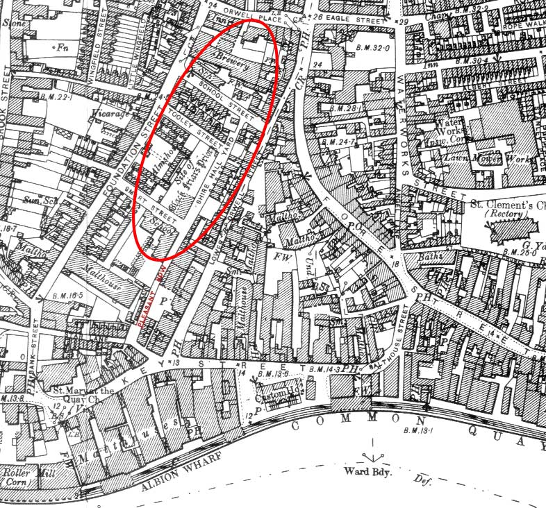
1902 map of Smart Street and Pleasant Row 1902
map
The red oval identifies the approximate site of the Dominican Friary of the Blessed
Virgin ('Blackfriars'– see our Monasteries page). The ruins
of the Friary church (as shown on our Almshouses
page) are the only monastic remains still standing in the town. 'If The Suffolk Traveller (1764, 40)
is right in saying that the Blackfriars' territory extended to Star
Lane, then Pleasant Row must have formed a back entrance to the
priory.' [M. Clegg: Streets and
street names in Ipswich; see Reading list]
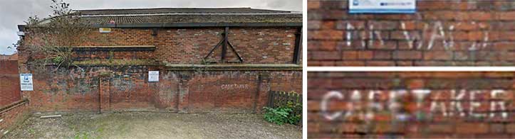
The bird's eye view of the school clearly shows the L-shaped
building with gardens and parking in the former playground. The newer
accommodation block, emulating the style of the school building, is the
furthest south on Pleasant Row. It has thermo-voltaic panels on the
roof to capture solar energy. The southern boundary wall of the car
park with its brick
butresses has hand-painted letters indicating the dedicated parking
spaces, presumably from the days of the school – Mr Ward must have been
the headmaster:
'MR
WARD CARETAKER'
2013
images
[UPDATE
29.5.2023: 'Reading your update on the Shire Hall Schools in Smart
Street took me right back to the 1980s when I was a graphic design
student at what was then Smart Street College. The name ‘Mr Ward’,
painted on the old playground wall, wasn’t a former Edwardian
Headmaster, but David Ward, who was one of the Art and Design lecturers
while I was a student. The other permanent lecturers all had their own
named spaces too but I suspect that they have disappeared under the new
additions. I remember them as I was one of the few students who drove
to college, in my Wolseley 16/60, so I saw the painted markings every
day. Thank you for all your work in keeping the history of Ipswich
alive. I still live in the town but work near Bury St Edmunds now. Best
wishes, Taff Gillingham.' Many
thanks to Taff for the personal recollections of Smart Street Schools.]
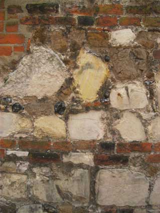
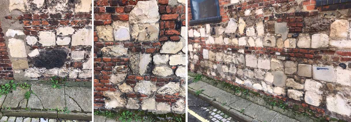
It's worth strolling down to the end of Pleasant Row to look at
the patched-together construction of the works wall opposite the
school. Could those blocks of stone have come from the old Shire Hall
building; could they in turn have come from the original Blackfriars
monastic buildings nearby? Selling or robbing out and reuse of building
materials – particularly those stone blocks not native to the area –
was a well known practice (see the 2023 photographs below).
Peeking through the broken pane at the northern end tells you
what goes on inside...
Pleasant Row: a hypothesis
Bob Malster's A history of
Ipswich (see Reading list) speculates:
'Perhaps it was the Cloth Company that occupied premises in Pleasant
Row, off Star Lane, from which the timber roof went in the 19th century
to Cholderton church in Wiltshire. This roof, advertised for sale in The Ipswich Journal as "superb
antique ornamental Gothic roof, 80ft. long and 19ft. wide within the
walls ... well deserving the attention of Antiquaries ...", has carved
on it the shears which were the emblem of the clothworkers.'
This takes us back to the national commercial dominance of Ipswich in
the wool trade. In April 1591 regulations were made for a fraternity
or company of clothiers, clothworkers, weavers, shearmen and dyers
which would control the cloth trade within the town and supervise the
binding of apprentices and employment of servants. This was the Cloth
Company.
[UPDATE
22 March 2023: 'Hi Borin, I was having a look around the Almshouses on
Foundation St today and came across a rather curious wall. It forms the
back wall of a business premises on Lower Orwell St. It’s on Pleasant
Row opposite the old school and looks to be mostly Victorian in age but
interspersed among the Victorian bricks are a number of what appear to
be limestone blocks and towards the far end, bricks that have a
distinctly Tudor appearance. You have probably spotted this wall
yourself but I was curious to find out your opinion of it. Could
building materials from the old Grammar school or Shire Hall, have been
put to another use after the demolition of both? I’ve attached some
images but a good view of the wall can be had via Google Maps. Regards,
Ben Squirrell.' Thanks to Ben for
taking some rather better photographs (included here) of this
fascinating, historic, despoiled corner of Ipswich.] 2023 images (above and below) of the
Pleasant Row wall courtesy Ben Squirrell
The
narrow pavement and battered kerbing still have their limestone setts
marking the gutter (not to mention the yellow line). It's a strange
amalgam of history, industry, make-do-and-mend and squalor. Ben notes:
'I was looking at the paving, kerb stones and sets this morning. They
do seem to be of some considerable age. If you look along the line of
the pavement, there is a drop kerb to nowhere, which would seem to
suggest the pavement pre-dates the wall.
Ben adds:
'Regarding Pleasant Row, I've been trying to get to grips with the
sequence of events for the wall. On the White
map of 1867, the Shire Hall has been demolished, to eventually be
replaced by the school. There is no building that sits on the boundary
with Pleasant Row, where the wall is situated, at this time. There is a
building with a fairly large garden or yard, on Lower Orwell St, that
appears to line up with the wall's position.Whether the wall is in
position at this time is impossible to say but having a garden/yard
there, gives a possible explanation for the drop kerb at least. Moving
on to the Ordnance Survey map of 1881, we see the school has been built
and a wall is clearly shown running along the boundary of the property
on Lower Orwell St. It would be interesting to find out some more
information about the properties along that stretch of Upper Orwell St.
The OS map of 1881 shows the Orwell Inn on the corner of Fisk's Court
but no clue to the identity of the buildings to the south of it. Moving
on to the 1902 OS map see detail above], the yard of the building on
Upper Orwell St, has been almost filled and there is a building right
on the boundary with Pleasant Row.
So what would represent a plausible explanation of the wall and its
many different parts? I would suggest at some point either before or
during construction of the school, the owner of the building with the
yard or garden backing on to Pleasant Row, was offered or took the
debris from the Shire Hall and/or maybe Black Friars Priory and made
good use of it. The masonry could have just been lying on the surface
or maybe it was unearthed when the footings for the school were being
dug. All idle speculation, of course.
I can confirm that I am related to Leonard Squirrell [one of the most
famous artist/illustrators from Ipswich, see our Blue
plaques page]. I believe he was a cousin of my Grandfather.'
Ben adds:'
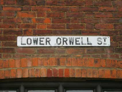
Lower Orwell Street: 'Emergency Water
Supply' Street
nameplate at the top of the slope
While we're in this area, stroll through the bit of Smart Street –
which is really a pokey pathway south of the overgrown Gym & Trim
site – into Lower Orwell Street. Here is a similar, rather neglected,
former industrial street similar to Pleasant Row; it was once the the poorest and sometimes the most lawless neighbourhood in the
town. It is home to a St Clement parish boundary
marker which we couldn't find, but luckily Paul Horne did and he's
recorded it for us on that page.
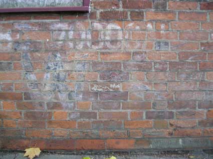
Also, there is vestigial lettering painted on the
red brick wall: 2013 image Just below a blocked up window one can
make out:
'7000GAL'
'W S...'
with possibly the rest of a
name to the right, now washed away. What can it all mean?
[UPDATE 28.7.2014: "I’ve just
stumbled upon your fascinating site. Under Smart Street / Pleasant Row
you query 7000GAL and “WS” painted on a wall. I believe that I can
explain.
During World War II the cellars of derelict and bombed buildings were
flooded to provide water for use by the fire service in the event of
water mains being damaged by bombing. These premises were labelled
“EWS” (Emergency Water Supply) in large white letters to assist
identification. I guess that your example has dropped the “E” at some
stage. I trust that this helps. Kind regards, Colin Norfolk" Many thanks to Colin for this rather
unexpected solution to the lettering conundrum of Lower Orwell Street.]
[UPDATE July 2015: As well as
conventional rigid water tanks. "these EWS reservoirs could also be
collapsible efforts like modern low-tech swimming/paddling pools; the
sides were waterproofed canvas with wooden frames to keep them rigid.
As such there wouldn't be anything left to see. The basements of
bombed/derelict buildings were also used as EWS, probably after some
minimum repairs to improve the water-holding ability." Quotation from
the web. There is another 'EWS' example in Appleby-in-Westmorland.
One of the major hazards during World War II was the threat of
incendiary bombs. Such was the risk many business's employed staff to
carry out Fire Watch duties which involved long periods on rooftops
usualy at night. There was a healthy spin-off in Fire Watch Ladders
being erected to allow thorough inspection of roofspaces. "It was
acknowledged early on in the war that fire could do more damage than
even the heaviest of bombing raids by the Luftwaffe. As water
mains were early casualties after a raid local authorities set up
additional means of water supply by means of large street borne
cisterns in various locations around the city. The water would have
been fed to the fire hoses by manualy operated or steam driven
pumps. Their location was marked in large letters on buildings at
street level with arrows and distance markers. Many of them
remained for a number of years after the war and were responsible for
number of drownings involving children." Quotation
from
the web.]
Compare with other schools' lettering: Ragged Schools
More schools (Argyle Street, Clifford Road, Bramford Road, Ranelagh
Road, Spring Road, Springfield Junior, Grey Coat Boys)
and Ipswich High
School.
 2013 images
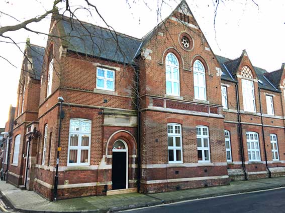 2021 images
courtesy Owen Thurtle
2021 images
courtesy Owen Thurtle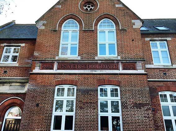
 2021 images
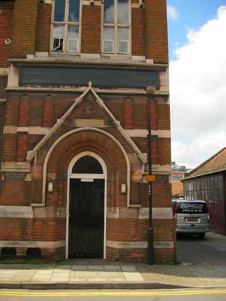
 2004 image
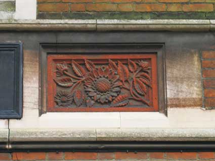 2017 images
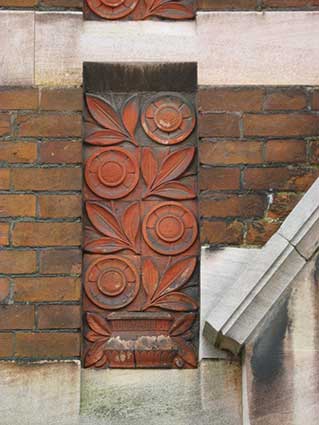
 2013 images
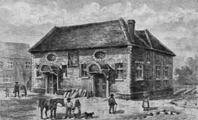 Images of Shire Hall
 2013 images
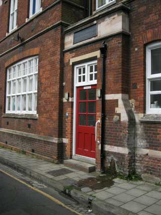
 2021 images
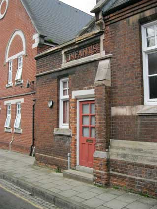
 1902
map
1902
map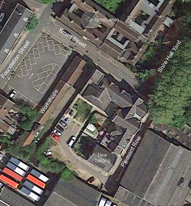
 2013
images
2013
images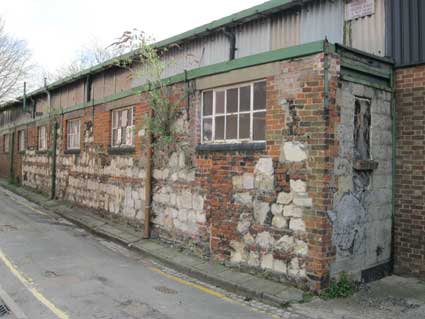
 Street
nameplate at the top of the slope
Street
nameplate at the top of the slope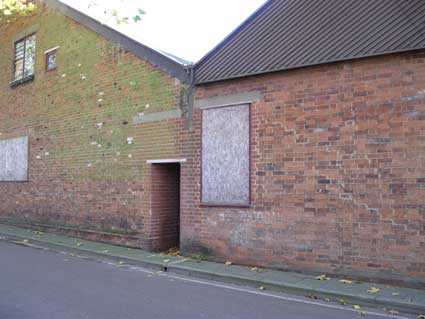
 2013 image