| Location |
Clegg |
2012 |
Photo |
Notes |
| St
Clement’s Parish |
||||
| Foxhall Road St Clements
Hospital at West side of second brick pillar from the east marked St C B 26 |
82 |
Y |
C7 |
|
| Asylum Lane between St Clements
Hospital & rear of Chilton/Temple Roads mid way down lane |
82 |
Y |
C10 |
Approx 225m from Foxhall Rd end of lane |
| Alexandra Park inside railing
facing Grove Lane marked 19* |
79 |
Y |
C8 |
At Grove Lane fence |
| Alexandra Park* |
79 |
Y |
C1 |
Nr Lodge at Grove Lane |
| Alexandra Park* |
79 |
Y |
C2 |
Nr play area overlooking College |
| Alexandra Park* |
79 |
Y |
C9 |
In the fenced play area above pond |
| Back Hamlet house 117, low brick
wall in front of house |
79 |
Y |
C3 |
|
| Bond Street house 40 |
79 |
N |
Unable to locate, 4 properties north of Eagle St junction |
|
| Lower Orwell Street – former
Barwell & Jones wall, opposite to the lane leading to Smart Street* |
79 |
Y |
C4 |
|
| Salthouse Lane Jewish cemetery
entrance, exterior |
79 |
Y |
C5 |
|
| Salthouse Lane Jewish cemetery
north wall interior |
79 |
Y |
C6 |
Behind a locked gate & a layer of ivy, photo taken 2007 |
| St
Margaret’s Parish |
||||
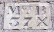
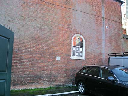
| St Helens Street - on old County
Hall opp Orchard Street – marked Mgt B 37x |
N |
Y |
M1 |
|
| Upper Orwell Street marked Mgt B
32 |
N |
Y |
M2 |
|
| Paget Road nr Anglesea Road
junction, side wall of 46 Anglesea Road marked MB |
N |
Y |
M3 |
Possibly a modern copy |
| Northgate Street house 9, south
of house part hidden by extension to number 7 |
79 |
N |
Unable to locate |
|
| St
Helen’s Parish |
||||
| 372 Woodbridge Rd opp Khartoum
Road
marked St H B 1900 |
Y |
H1 |
Painted on side of former shop property wall |
|
| St
Mary le Tower Churchyard |
||||
| South of churchyard marked -
Tower Church Yard Boundary marked TCYB 1862 |
79 |
Y |
T1 |
"possibly moved during Tavern Street widening (1979)" loose & not in situ (2012) |
| South of churchyard marked -
Tower Church Yard Boundary marked TCYB 1862 |
79 |
N |
"possibly moved during Tavern Street widening (1979)" not found (2012) |
|
| Prison
Commissioners |
||||
| Grimwade Street inside entrance
to County Hall right hand side at site of former County gaol |
79 |
N |
Not accessible in 2012 |
|
| Grimwade Street inside entrance
to County Hall right hand side at site of former County gaol |
79 |
N |
Not accessible in 2012 |
|
| Artillery
Barracks |
||||
| Anglesea Road, house 23 marked
No 12 1Ft in front |
Y |
WD8 |
||
| Anglesea Road, entrance to
Geneva Road, East Side marked W D No 8 3ft ?? in front |
79 |
Y |
WD3 |
|
| Anglesea Road, entrance to
Geneva Road, West Side marked WD No 11 1 ft |
79 |
Y |
WD2 |
|
| Berners Street house 89, back
garden wall marked W D 3ft No. 5 1ft in front |
79 |
N |
Unable to confirm |
|
| Berners Street west side service
area behind St Matthews Street on North Wall marked W D 15 ins in front |
79 |
Y |
WD5 |
|
| Berners Street west side service
area behind St Matthews Street on North Wall marked 19 ??? The boundary of the barracks 15 inches from the face of this wall |
79 |
Y |
WD6 |
|
| Barrack Lane near Cecil Road
brick entrance pillars capped with stone ball, west side marked W D No 1 10 ft in front |
79 |
Y |
WD1 |
|
| Barrack Lane entrance pillars |
WD1,7 |
|||
| Militia
Barracks |
||||
| Anglesea Road West side of
radiotherapy unit - 1859 the boundary of the ground belonging to the East Suffolk Militia depot extends thirty inches beyond the face of this stone |
79 |
Unable to locate §§§ | ||
| Anglesea Road East side of
radiotherapy unit - 1859 the boundary of the ground belonging to the East Suffolk Militia depot extends twenty three inches beyond the face of this stone |
79 |
Unable to locate §§§ | ||
| Unconfirmed |
||||
| St Margaret’s parish boundary
stone - Dyke St unconfirmed |
N |
Y |
M4 |
Potential stone, St George's Street car park rear wall |
| Berners Street another artillery
barracks stone, unconfirmed |
N |
N |
Mentioned in Clegg, unable to locate |
|
| Ipswich
Borough boundary stones |
||||
| Foxhall Road o/s house 661 stone
|
N |
Y |
IB1 |
|
| Norwich Road
o/s house 569 stone +++ |
N |
Y |
IB3 |
Milestone |
| Hadleigh Road - Chantry Park
Gates IBC concrete marker IBC |
N |
Y |
IB2 |
|
| Whitton Lane, stone to side and
below Graham plumbers merchants off Anglia Parkway North |
N |
Y |
IB4 |
|
| Tuddenham Road, stone, at north
west corner of rail bridge near Humber Doucy Lane junction |
N |
Y |
IB5 |
 2016 images
 Photographs
courtesy Mike Bardell
Photographs
courtesy Mike Bardell