Milestones*
(67, 68, 69, 70, 71 and more)
[*Specialists favour 'milestone' for all markers such
as
those shown here, even though they are made of cast iron; the term
relates to the ground-level siting of the sign. One assumes
that 'milepost' is more suited to the tall direction indicator signs
such as that seen in Yoxford.]
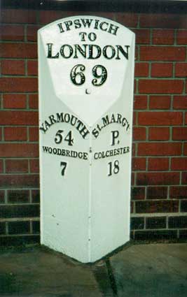
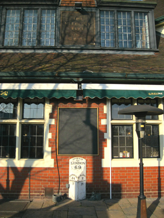
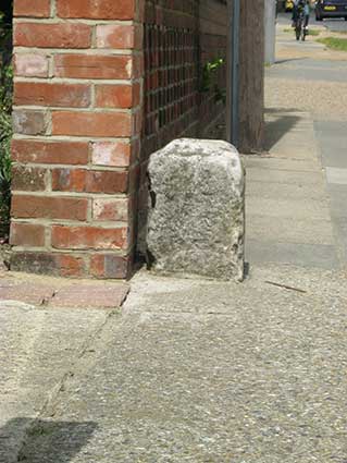
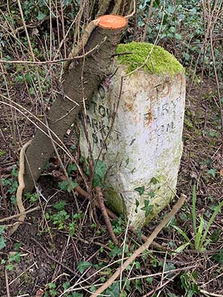
'69' outside 5 Woodbridge Road
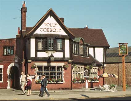
Outside the Milestone public house at nos. 3-5 Woodbridge Road (in 2012
the name reverted to The Mulberry
Tree)
on the corner with St Margarets Street, we find the example shown below:
'IPSWICH
TO
LONDON
69
YARMOUTH
54
WOODBRIDGE
7
St.MARG't
P.
COLCHESTER
18'
 2001 image
('St.Marg't P.' refers to St.
Margaret's
Parish). The '69' milestone is the first on the
Ipswich to Yarmouth Turnpike Road (see below for a note about the Turnpike Trust). These
original milestones
are Listed Grade II objects, so we are informed by Ed Broom (his
Freston.net
site
is on the Links page.), who consulted the
Ipswich
Borough Council website (ibid.)
to check [October, 2004].
[UPDATE 11.2.12:
We noticed that the pub on the corner of St Margaret's Green and
Woodbridge Road (variously The Mulberry
Tree, The Milestone, The
Beerhouse etc. over the years) is being refurbished and reverting to
its original name. The central pub sign panel on the upper front wall
had been removed and an early, peeling sign revealed. We took the
opportunity to record this and the milestone.]
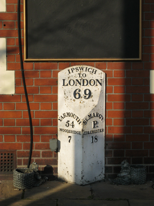
 2012 images
Below: the Mulberry Tree in 1983 showing the milepost
sited by the pub wall.
 Photograph
courtesy The Ipswich Society
Photograph
courtesy The Ipswich Society
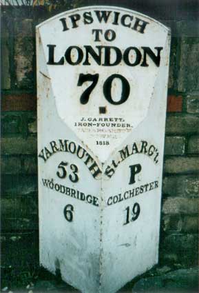
'70' outside
325 Woodbridge Road, Albion Hill
The milestone below is a mile, obviously, further up
the
road, sited
outside
325 Woodbridge Road, opposite St Mary's Church Hall and the former
Convent site. (For more information on Albion Hill, Holme Wood and the
convent/St Mary's housing development see Sunny
Place.)
The Grade II Listing states: "1 of a series of milestones set up as
facings to earlier stones by the Ipswich Southtown (Gt Yarmouth)
Turnpike Trust." It was
placed on Albion Hill by The Ipswich To South Town & Bungay
Turnpike
Trust and gives rather more information:
 2001 image
The word 'IPSWICH' is set on a curve following the top
edge of the casting; this curve is repeated on the 'YARMOUTH' and 'St.
MARG'T' lettering which are on raised steps:-
'IPSWICH
TO
LONDON
70
YARMOUTH
53
WOODBRIDGE
6
St. MARG't. P
COLCHESTER
19'
and
in the central triangle:
'J.GARRETT.
IRON-FOUNDER.
(ST. MARGARET'S.
IPSWICH)
1818'
[UPDATE August 2003: the iron founder's details are
not picked out in black paint at the
time of the photograph, but
repainted,
somewhat clumsily – the date is now unreadable under the paint.]
See also our page on the old
toll-house (now Barclays bank) on the junction of Woodbridge Road
and Rushmere Road.
Jacob Garrett (and Garrett
Garrett) ironfounders
'J. GARRETT' is a member of the
famous
Leiston ironfoundry family, brother of Richard Garrett who founded it.
Jacob
Garrett started business in Ipswich as a whitesmith (one who works with
tinplate), coachbuilder and bell-hanger. In 1802 he set up an iron
foundry earlier occupied by John Cobbold the renowned brewer) at the
corner of St Margaret's Green and Cobbold Street. In 1803 he was
advertising for 'old cast iron' urgently needed 'to execute an unusual
order for the Government'. J. Garrett's foundry in St Margaret's
parish, Ipswich produced these and
many other Suffolk milestones including those for the Little Yarmouth
Turnpike and those from Darsham to Bungay.
(Information on Jacob Garrett from Malster, R.
See Reading List.)
The family links of Jacob Garrett seem to be contradicted by the
quotation from Linda Sexton's book on the Ipswich
to South Town [Great Yarmouth] and Bungay Turnpike Trust (below).
Incidentally, milestone no. 72 at Kesgrave was made by another local
foundry: Cocksedge, Ipswich.
[UPDATE
30.1.2022: 'Good
afternoon Mr B! I was prompted to write having walked past the '68'
milestone in London Road on my way to Halford's. I was able to decipher
"Garrett ironfounders St Margaret's Ipswich" and a date 18(illegible).
Naturally my first thought was of the Leiston Garretts. On returning
home I googled what I deciphered above and was taken first to a site
called Issuu, which reproduces an article on the splendidly named Mr
Garrett Garrett. Said article places the ironworks very precisely at
'14-16 Cobbold Street', so not quite on the corner as stated in your
beautifully detailed account of all that sequence of milestones. Must
have been a tiny place! James Meek.' The
page to which James refers is here
which has tantalisingly little information about the book from which
this information comes. Many thanks to James for sending this;
lepidopterist and failed ironfounder Garrett Garrett died in London in
1890 aged 82.] James deduces that this may have come from The Proceedings of the Suffolk
Naturalists’ Society, c.1946. 14-16
Cobbold Street is beyond the boundary wall of the Manor Ballroom car
park and has the large covered building at the back of The Mulberry
Tree/Milestone pub behind it; it is now covered by modern housing.
However, we think that the numbering as well as the house configuration
has changed over time.The 1867 map shown below has gardens behind 'St
Mary's House'/The Manor House (marked in green); on the 1902 map there
appear to be two small buildings on part of that site. But looking
across the road (1902 map), we see 'Iron Wks' running back from St
Margarets Green on the north corner of Cobbold Street (marked in red) –
surely this must be the site of Jacob Garrett's foundry.
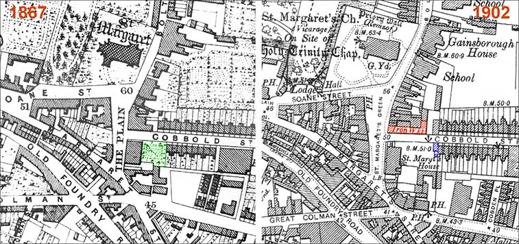 Comparative
map deaails
Comparative
map deaails
The photograph below is from The Ipswich Society's Image Archive
(to whom our thanks; see Links) showing that
corner in 1984 when the three buildings on St Margarets Green were
occupied by Brittania Stores (furniture, carpets etc.). The building on
the north corner of Cobbold Street, particularly the one with the
pitched asbestos roof, certainly resemble a works. Behind the shop in
the 21st century these buildings have been replaced by modern housing.
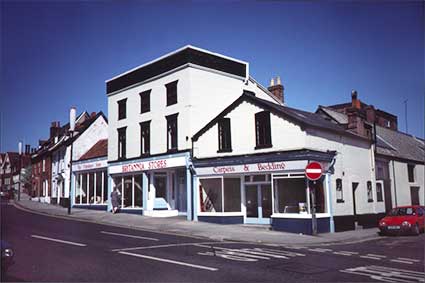 1984
image courtesy Ipswich Society
1984
image courtesy Ipswich Society
The Turnpike Trusts
"Why were these roads called 'turnpikes'? In earlier times pikemen were
guards stationed outside the monarch's audience chamber. Entry to the
royal presence would be barred by crossed pikes, which were 'turned'
aside to allow entry... Essentially a turnpike is a barrier barring the
way, but which can be moved to allow traffic through under
pre-determined conditions."
"An Act of 1744 made milestones compulsory on most main roads and the
General Turnpike Act of 1766 required all turnpike trusts to erect
milestones or posts along the length of all the roads the they
controlled. The Ipswich to South Town [Great Yarmouth] and Bungay
Turnpike Trust was inaugurated on Friday 20 May 1785. The original
stones between Ipswich and Yamouth were repaired and relettered in
1799, but in 1817 the trustees asked the surveyor to obtain estimates
for the cost of encasing the milestones along the whole length of the
road in iron, with figures denoting the distances. In October 1817
Jacob Garrett, an Ipswich founder, contracted with the Trust to do the
work... Garrett was expected to complete the work in nine months, by
the following July, The sum agreed was not to exceed Ł100."
"The '69' milestone
[outside The Mulberry Tree] is the first on the Ipswich
to Yarmouth Turnpike Road... This is but a short distance from St Margaret's Plain [Green], where the foundry
in which it was made used to be situated, and is also close to the
starting point of the turnpike itself. Very little is known about Jacob
Garrett. He does not appear to be linked to the Garretts of Leiston,
and Ipswich Record Office has no documents from the business. Other
turnpike roads in the area have milestones of a similar design. The
sides of the milestone are angled to indicate the direction of the
major town as well as the distance to it. The side facing the oncoming
traveller shows the next major town in that direction. Milestones were
painted white [with black characters/numerals] so that they would show
up in poor light."
(Quotations from Sexton, L.: Fifty four miles to Yarmouth see Reading List.)
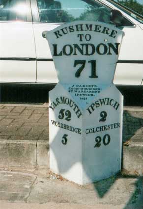
'71' described by the Grade
II Listing as "outside Mann Egertons Garage"
Below is Ipswich's most flamboyant milestone,
the
next in the sequence placed by this Turnpike Trust. Its
flaring top
distinguishes
it from the others, but it still bears the same ironfounder's mark and
date. Ironically it is to be found in the shadow of a petrol filling
station on Woodbridge Road East.
 2004 image
'J.GARRETT.
IRON-FOUNDER.
ST. MARGARET'S.
IPSWICH
1818'
but for some
reason the physical shape of the cast has been altered, either that, or
the shape was similar to the others and some defect caused the foundry
to
cut away the shoulders ('LONDON' definitely look squeezed into the
space):
'RUSHMERE
TO
LONDON
71
YARMOUTH
52
WOODBRIDGE
5
IPSWICH
2
COLCHESTER
20'
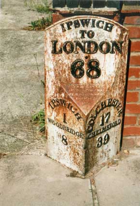
'68'
outside
140 London
Road
The same ironfounder's
details are to be found on
the (in 2004) rather more neglected milestone, shown below, outside 140
London
Road,
not far from the Handford Road junction. It also is Listed Grade II.
But this one is dated 1831.
Now
a residential street, this once served as the main Turnpike route into
the
centre of the town from the western approaches: a function now
fulfilled
by Handford Road.
 2004 image
'IPSWICH
TO
LONDON
68
IPSWICH
1
WOODBRIDGE
8
COLCHESTER
17
CHELMSFORD
39'
And in the
central triangle:
'J.GARRETT.
IRON-FOUNDER.
(ST. MARGARET'S.
IPSWICH)
1831'
This largely forgotten milestone shows the rime of rust
from
years of
neglect
, but is still readable.
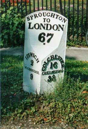
'67' outside Avenue
Lodge, Chantry Park
Below is another milestone on London Road, this
time on the far
busier
arterial route towards the Colchester and the capital, here the A1214.
It stands near
to
the top of Crane Hill, close to the entrance
to Chantry Park and the
photograph
had to be taken while standing in the bus lane with traffic roaring
past.
While it appears to be identical to the other posts shown above, the
ironfounder's
mark on the central triangle here is: 'E.R. & F. TURNER 1862',
although
it is not picked out in black paint.
E.R. & F. Turner
We know far more about this founder than J. Garrett, discussed
above. The firm of E.R. & F. Turner was founded in 1837 and its
premises in College Street near the Wet Dock were known as St Peter's
Ironworks. In 1911 they acquired the Stowmarket firm of Bull Motors and
in 1924 the manufacture of electric motors moved from Stowmarket to
Ipswich, become an integral part of Turner's. From 1937 the work
relocated to a large site on Foxhall Road – many will remember Bull
Motors next to the Celestion loudpseaker factory (currently at Great
Blakenham) here. Bull Motors closed in 2000, due to a series of changes
of ownership and the site is now residential. In 1969 W.G. Gosling
purchased Turner's flour and flake milling business. Christy-Turner in
Knightsdale Road continue the pulverizer and hammer mill business.
 2004 image
'SPROUGHTON
TO
LONDON
67
IPSWICH
2
WOODBRIDGE
9
COLCHESTER
16
CHELMSFORD
38'
Although it had been restored and repainted,
this milestone needed rebedding and returning to its upright position
when photographed in 2004.
The Borough's Local list tells us: "Milestone Number 67 (Chantry Park).
This cast iron milestone sits by the curb a few yards away from the
London Road entrance to Chantry Park. Dating from 1862 it replaced an
earlier stone marker that was set in place by the Ipswich to Southtown
and Bungay Turnpike Trust. The trust was established in 1785 and was
responsible for road maintenance between Ipswich – then an up and
coming town with a population approaching 11,000 – and Southtown (Great
Yarmouth)." The statements about this
Trust by Linda Sexton (above), name the first milestone ('69') erected
by this Trust sited outside The Mulberry Tree in Woodbridge Road
('70'). Presumably the Trust extended its influence through the town
with at least two milestones shown here ('67' and '68'). The Suffolk
Milestones website: 'Cast iron mileposts were often attached to the
earlier milestones when the lettering became too worn to be read,
and these lasted well across the intervening two centuries as
long as there was no impact damage. They are common on the
Ipswich to Southtown (now Great Yarmouth) Turnpike which passed through
the county along a route now traced by the A12. This Turnpike connected
with others reaching back to London through Essex.'
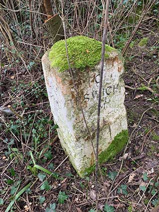
St Matthew's Parish milestone
Below is the milestone on the junction of Chevallier Street and
Norwich
Road. Like the Chantry Park example, it had been restored in 2004.
The Grade II Listing states: "An early C19 cast iron milestone restored
and repaired after damage and re-erected at the present site." Standing
on the grassed area under trees on the corner opposite the Inkerman
pub,
this strikes one as being of an earlier vintage: smaller in stature,
bearing
smaller characters with less information and feeling the need to spell
out
'miles':
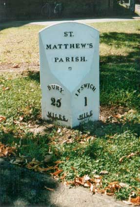 2004 image
'ST.
MATTHEW'S
PARISH.
BURY
25
MILES
IPSWICH
1
MILE'
Norwich Road milestone
outside 569 Norwich Road
 2016
images
2016
images
There just remains the genuine (stone) milestone
on Norwich Road, which
doesn't
bear any lettering, but might have borne a metal plate with mileage
details
at some time. There are metal bolts in the top and front face of the
stone.

[UPDATE 27.10.2016: Michael
Bardell of the Milestone Society points out that this feature appears
on a late 19th/early 20th century map: "Checking the OS map reveals a
milestone with bench mark and an absence of a boundary thereabouts."
Although it features in Paul Horne's list of Ipswich boundary markers ('IB3'), it
is confirmed as a milestone.]
Ipswich,
the
county town of Suffolk, has retained all seven milestones (plus one
actual milestone)
within the town boundaries. All but one still stand on the arterial
roads
into the town as they did in the days of the Turnpike Trusts. Two stand
on Norwich Road, which was part of the first Suffolk Turnpike in 1711
for
the roads between Ipswich and Scole. Three are on Woodbridge Road and
two
on London Road. By comparison, Lowestoft has retained none of its
milestones.
This could have been due to the ravages of time, road 'improvements',
vandalism,
or just the Government's edict in the early years of the Second World
War
that milestones should be removed/ defaced to confuse the invading
Bosch.
The shapes, styles and materials of these forgotten roadside markers
are
fascinating. They deserve restoration and recognition. Thank goodness
that
there is a Milestone Society (see the scholarly
Suffolk
Milestones
website listed on our Links page)
and that Suffolk's waymarkers are so well surveyed and reviewed in the
same
place. Incidentally, the Milestone Society has a photograph of a
milestone somewhat similar to that outside 569 Norwich Road. It is said
to be situated on the unclassified road (formerly the A14), location
'By the road' at Whitton with the incised legend: 'TO BURY 23; 3 IPSWICH 3M' – but we haven't found
it yet...
[UPDATE
5.2.2025: we found Ipswich
information , a small format, 4-page newsletter published by
Ipswich Corporation (no. 62, Nov./Dec, 1974). It features this article about the Ipswich milestones,
with information and images of the milestones – which looked much
better in 1974.]
Milestone, Old Norwich Road
 2021
images
2021
images
Carved into each face of the stone is, on the one facing Claydon:
'TO
IPSWICH
3M'
... on the one facing the road:
'TO
BURY
20M'
... on the one facing Ipswich:
'TO
STOW
MARKET
9M'
Away from the cast iron milestones in Ipswich town, this is very
much an old, traditional milestone. It must have been aimed at foot and
horse travellers who might need reassurance that they were on the right
road, because it is set outside the Borough boundary and not near any
habitation. The vegetation has clearly completely covered this
milestone in the past, but a recent (early 2021) clearance has now
revealed it. Oddly, we haven't been able to identify this stone on the
Suffolk Milestones website (see Links).
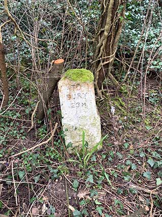
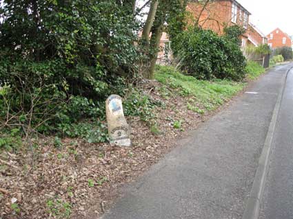
Sproughton Parish milestone
Changes in the administrative boundaries possibly brought this
milestone inside the borough urban area from the rural Sproughton
parish. It is on Hadleigh Road, almost opposite the entrance to Chantry
Park.
 2013 images
'SPROUGHTON
PARISH
IPSWICH
2
WOODBRIDGE
9
HADLEIGH
8
SUDBURY
20'
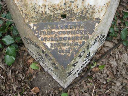
and in the central triangle:
'J. GARRETT
IRON FOUNDER
ST MARGARETS
IPSWICH
1832'
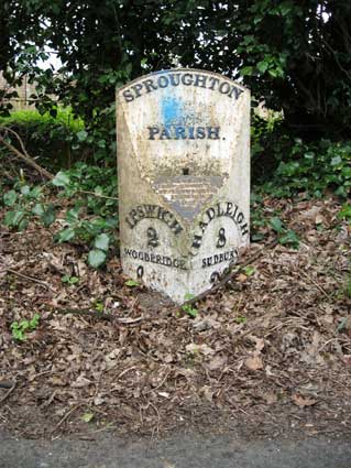
As with other examples shown on this page, the numeral '9' at the lower
left is curious: looking hand-painted
rather than a cast character. It is as if the casting dropped off and
had to be hastily hand-numbered. Leaves and debris cover most of the
lower '20' on the lower right.
See The
Suffolk Milestones website for much more.
See our Aldeburgh page for a lettered
milestone near to the White Hart. Milestones and mileposts occur in
many towns and villages e.g. Hadleigh, Yoxford.
See also our Lettered castings
index page.
Home
Please email any comments and contributions by clicking here.
Search Ipswich
Historic Lettering
©2004 Copyright
throughout the Ipswich
Historic Lettering site: Borin Van Loon
No reproduction of text or images without express written permission