Mike O'Donovan, our
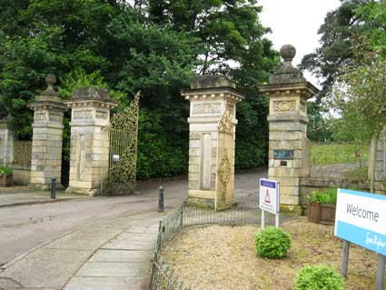
parks correspondent, has sent in images of Chantry Park gates taken in
spring 2011. (The area of interest for us is the pilaster nearest the
lodge and its plaque.)
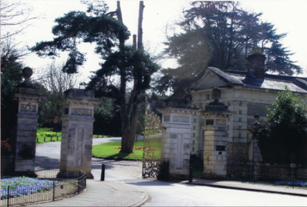
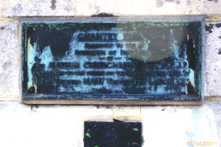
'They show the Hadleigh Road entrance to Chantry Park. Sadly the plate is weather worn (see below). The inscription reads as follows...'
'CHANTRY PARK

'They show the Hadleigh Road entrance to Chantry Park. Sadly the plate is weather worn (see below). The inscription reads as follows...'
PRESENTED TO THE
BOROUGH OF IPSWICH
------BY-----
SIR ARTHUR CHURCHMAN BART., M.P. J.P.
AND OPENED TO THE PUBLIC ON THE 20TH OCTOBER 1928, BY
H.R.H. PRINCESS MARY VISCOUNTESS LASCELLES'
The Listing (Grade II)
description reads:
"Gate House and entrance gate piers to Chantry Park. A monumental white brick and stone lodge designed as a small temple in a free classical style. Possibly of the same date as the alterations to the Chantry in the mid C19. It has paired banded corner pilasters, a triglyph frieze and a pediment on the front. A central 8-panel door with small side windows has a pediment on console brackets. Above the doorway there is a range of windows separated by inverted consoles. The side elevation has 2 windows with rusticated surrounds and voussoired heads.
The gateway to the park sets back from the road with a low brick wall on either side which sweeps in concave curves with a stone coping and wrought iron railings between consoles. Heavy wrought iron gates of mid C19 have 4 square stone rusticated piers with cornices and ornamented friezes. The centre, larger, piers have faces carved on the front and the outer piers have ball finials."
The gates
Here are more images from May 2014.
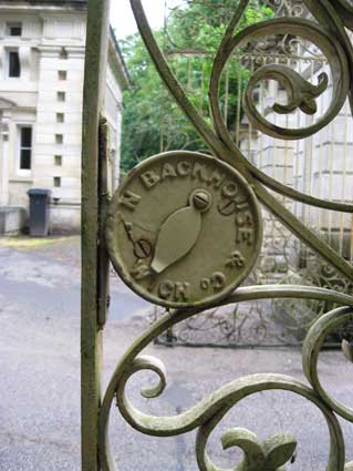
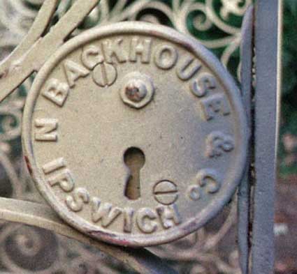
The locks on the park gates (somewhat damaged) is lettered:
 2014 images
“The origin of The Chantry (now a nursing home) is a chantry to St Thomas Becket at St Lawrence’s Church [in the town centre], founded in 1514-15 by Edmund Daundy, Thomas Wolsey’s uncle and one of Ipswich’s wealthiest merchants [see also our Lady Lane page]. The chantry was endowed with 100 acres (40 ha.) of land on the edge of Ipswich. By 1668 the property was owned by Sir Peyton Ventris, who died in 1691, and his son Edmund is supposed to have rebuilt the house c. 1700. Little is known about the old house, but it was taxed on sixteen hearths in 1674. After Ventris’s death in 1740 improvements were made by the new owner, Sir John Barker, and again from 1772 by Metcalfe Russell, who added the top floor. So one has a stuccoed house of five bays and two and a half storeys, with a three-bay pediment on the N (entrance) front. On rainwater heads the date 1772. To this, in 1853-4, wings of one bay, a porte cochere of two storeys and a three-bay two-storey bow at the back were added for Sir Fitzroy Kelly, all in a debased classical or free Renaissance style. The bands of vermiculated rustication are particularly telling. Equally telling the Entrance Gates in Hadleigh Road, and the little white-brick and stone Lodge, looking like a very grand classical mausoleum. The architect for all this work seems to have been R.M. Phipson, and perhaps he was responsible for the interior also.” [Bettley/Pevsner, see Reading List]
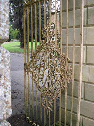
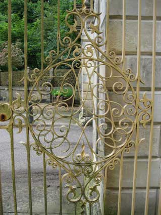
Question: is this motif in the centre of the pedestrian side gates a monogramme? Or just a symmetrical rococco pattern? The most obvious initials would be those of Arthur Churchman ('AC'), but they don't seem to fit. These rather fine, wrought iron gates boast dense patterns of curlicues, particularly on the side panels.
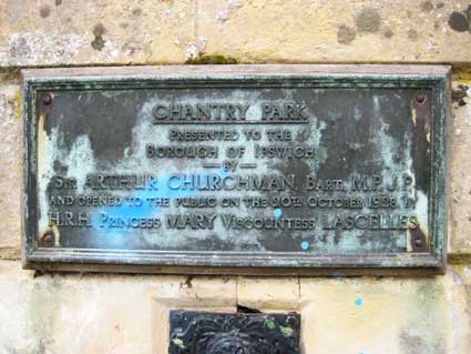
The last 2014 photograph shows a clearer image of the metal plate on the right hand pier, showing the inscription more clearly despite the statutory smear of vandal's spray-paint.
Sir Arthur Churchman
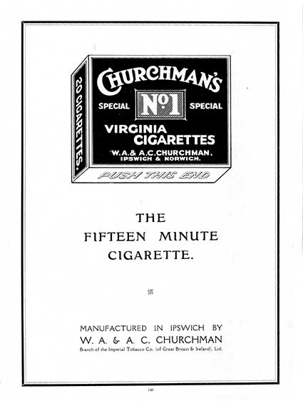
In 1927 the land where Chantry Park is now situated had been sold for housing development and was then purchased by Sir Arthur Churchman (later Lord Woodbridge) who gave it to Ipswich Corporation to be held in permanent trust for the people of Ipswich. Baron Woodbridge, of Ipswich in the County of Suffolk, was a title in the Peerage of the United Kingdom. It was created on 17 June 1932 for Sir Arthur Churchman, Conservative Member of Parliament for Woodbridge from 1920 to 1929. The title became extinct on his death on 3 February 1949. Sir William Churchman, 1st Baronet, was the elder brother of Lord Woodbridge. Incidentally, his philanthropic deeds did not stop at Chantry Park. Sir Arthur Churchman bought Orford Castle in 1928, and in 1930 gave the property to the Orford Town Trust; an appeal for money to maintain and restore it began shortly afterwards. Colonel Sir William Alfred Churchman, 1st Baronet VD (1863 – 25 November 1947) was an English tobacco manufacturer and public servant. Churchman was born in Ipswich, Suffolk. He went into partnership with his brother, Arthur, in the family tobacco firm which had been founded by their great-grandfather in 1790. This was renamed W. A. & A. C. Churchman. It was later absorbed by the tobacco combines and Churchman became a director of the Imperial Tobacco Company. Some may recall the Churchman's factory in Portman Road and their product: Churchman's No. 1 cigarettes. 1950s advertisements showed, variously, glamourous women and (disturbingly) a horse and a poodle smoking the product.
 2014 image
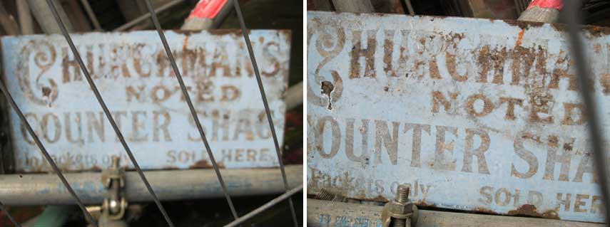
This enamelled metal shop sign was spotted at an open day in May 2014 at the Church of St Michael, Upper Orwell Street (burnt down in 2011). It is a reminder of a locally-marketed brand of tobacco from the Churchman's factory at the top end of Portman Road. It reads:
The curious curlicued initial 'C' is simplified, making the brand name more readable. 'In Packets Only' is now accompanied by 'The best lasts longest'. In the modern times of tobacco advertising bans and an awareness and recognition of the deleterious effects of smoking on human health, these advertisements ring rather hollow. With the benefit of hindsight, the immense wealth accrued by the Churchman family was based on very dubious aspects of human activity: slavery on tobacco plantations, the pedalling of addictive drugs to young people and women and so on.
 1932
advertisement
Apart from the words 'PUSH THIS END' on the base of the cigarette pack, perhaps the oddest thing is the inclusion of a small swastika* between the words 'Cigarette' and 'Manufactured'.
[*The swastika is a geometrical figure and an ancient religious icon in the cultures of Eurasia, used as a symbol of divinity and spirituality in Indian religions. In the Western world, it was a symbol of auspiciousness and good luck until the 1930s, when it became a feature of Nazi symbolism as an emblem of Aryan identity and, as a result, it was stigmatized by its association with ideas of racism and antisemitism.
The name swastika comes from Sanskrit meaning 'conducive to well being' or 'auspicious'. In Hinduism, the symbol with arms pointing clockwise is called swastika, symbolizing surya (sun), prosperity and good luck, while the counterclockwise symbol is called sauvastika, symbolizing night or tantric aspects of Kali.]
The following is from the English Heritage Register of Parks and Gardens of Special Historic Interest.
"The Ipswich Chantry was founded in 1509 by Edmund Daundy, a prominent and respected Ipswich merchant [he was a Member of Parliament for Ipswich in 1512 and 1515, not to mention the uncle of Cardinal Thomas Wolsey]. After the Ipswich priories were suppressed in 1536, the Cutler family were said to be in occupation of a house at the Chantry and by 1668 the land was in the ownership of Sir Peyton Ventris. Sir Peyton was succeeded in 1691 by his son Edmund who built a house in about 1700 which is believed to be the foundation of the present house (Pevsner and Radcliffe 1975). Edmund died in 1740 and the estate was sold to Sir John Barker who made substantial improvements to the house. The Chantry changed hands again in 1772, being purchased by Metcalf Russell who added a further storey and passed the land on to his elected heir Michael Collinson. From 1795 onwards Michael's son Charles enlarged the estate to 500 acres (about 208 hectares) and it is he who was responsible for developing the character of much of the registered park which survives today (1998). He planted the South Avenue (1807) and made further modifications resulting in it being described as having woodland groves, a lake covering several acres and studded with little islands (dated 1828), and gardens of rare and exotic plants laid out with meticulous care (Kelly 1844).
In 1836 the estate was purchased by Charles Lillingston who married the daughter of the Rev Fonnereau of Christchurch Mansion and on the occasion of their daughter's fifteenth birthday the local paper carried a lengthy description of the park where the celebrations were held. Lillingston was attributed by White's Directory of 1844 as having made many improvements to the house and grounds. His son and heir however was killed in action, resulting in another sale in 1852 when Sir Fitzroy Kelly, a distinguished barrister and MP for Ipswich, became the new owner. Kelly is also said to have applied great energy to his new property, making many alterations to the house in the Italian style (White 1844). He commissioned the new gates and lodge at the north entrance and called in Mr Nesfield (assumed to be W A Nesfield (1793-1881) to provide a scheme for the flower gardens on the south front (Inspector's report). His stay was also short though, and he sold the site to Charles Binney Skinner in 1867. By 1897 the house and park had been sold again to Sir Henry Cecil Domville. The Domvilles lived lavishly in the Edwardian style but Sir Cecil died suddenly in 1902 and his widow went to live abroad. When the Jump family arrived in 1906 the grounds had become very neglected but Mrs Jump was a keen gardener and with the help of Mr Nottcutt of Woodbridge improved the gardens and added new features. In 1927 when the Chantry again came up for sale it was purchased by George Gooday with the intention of developing a housing estate. Sir Arthur Churchman, a JP and member of the Council intervened, however, purchasing the house and park and presenting them to the borough as a public amenity which was opened by Princess Mary in 1928. Since that time the house has been leased as a nursing home and the walled kitchen gardens are currently (1998) used as a nursery by the Borough Parks Department."
"Gate House and entrance gate piers to Chantry Park. A monumental white brick and stone lodge designed as a small temple in a free classical style. Possibly of the same date as the alterations to the Chantry in the mid C19. It has paired banded corner pilasters, a triglyph frieze and a pediment on the front. A central 8-panel door with small side windows has a pediment on console brackets. Above the doorway there is a range of windows separated by inverted consoles. The side elevation has 2 windows with rusticated surrounds and voussoired heads.
The gateway to the park sets back from the road with a low brick wall on either side which sweeps in concave curves with a stone coping and wrought iron railings between consoles. Heavy wrought iron gates of mid C19 have 4 square stone rusticated piers with cornices and ornamented friezes. The centre, larger, piers have faces carved on the front and the outer piers have ball finials."
The gates
Here are more images from May 2014.
The locks on the park gates (somewhat damaged) is lettered:
'N BACKHOUSE & Co ...
IPSWICH'
with the gate house glimpsed in the background.
 2014 images
“The origin of The Chantry (now a nursing home) is a chantry to St Thomas Becket at St Lawrence’s Church [in the town centre], founded in 1514-15 by Edmund Daundy, Thomas Wolsey’s uncle and one of Ipswich’s wealthiest merchants [see also our Lady Lane page]. The chantry was endowed with 100 acres (40 ha.) of land on the edge of Ipswich. By 1668 the property was owned by Sir Peyton Ventris, who died in 1691, and his son Edmund is supposed to have rebuilt the house c. 1700. Little is known about the old house, but it was taxed on sixteen hearths in 1674. After Ventris’s death in 1740 improvements were made by the new owner, Sir John Barker, and again from 1772 by Metcalfe Russell, who added the top floor. So one has a stuccoed house of five bays and two and a half storeys, with a three-bay pediment on the N (entrance) front. On rainwater heads the date 1772. To this, in 1853-4, wings of one bay, a porte cochere of two storeys and a three-bay two-storey bow at the back were added for Sir Fitzroy Kelly, all in a debased classical or free Renaissance style. The bands of vermiculated rustication are particularly telling. Equally telling the Entrance Gates in Hadleigh Road, and the little white-brick and stone Lodge, looking like a very grand classical mausoleum. The architect for all this work seems to have been R.M. Phipson, and perhaps he was responsible for the interior also.” [Bettley/Pevsner, see Reading List]


Question: is this motif in the centre of the pedestrian side gates a monogramme? Or just a symmetrical rococco pattern? The most obvious initials would be those of Arthur Churchman ('AC'), but they don't seem to fit. These rather fine, wrought iron gates boast dense patterns of curlicues, particularly on the side panels.


The last 2014 photograph shows a clearer image of the metal plate on the right hand pier, showing the inscription more clearly despite the statutory smear of vandal's spray-paint.
Sir Arthur Churchman
In 1927 the land where Chantry Park is now situated had been sold for housing development and was then purchased by Sir Arthur Churchman (later Lord Woodbridge) who gave it to Ipswich Corporation to be held in permanent trust for the people of Ipswich. Baron Woodbridge, of Ipswich in the County of Suffolk, was a title in the Peerage of the United Kingdom. It was created on 17 June 1932 for Sir Arthur Churchman, Conservative Member of Parliament for Woodbridge from 1920 to 1929. The title became extinct on his death on 3 February 1949. Sir William Churchman, 1st Baronet, was the elder brother of Lord Woodbridge. Incidentally, his philanthropic deeds did not stop at Chantry Park. Sir Arthur Churchman bought Orford Castle in 1928, and in 1930 gave the property to the Orford Town Trust; an appeal for money to maintain and restore it began shortly afterwards. Colonel Sir William Alfred Churchman, 1st Baronet VD (1863 – 25 November 1947) was an English tobacco manufacturer and public servant. Churchman was born in Ipswich, Suffolk. He went into partnership with his brother, Arthur, in the family tobacco firm which had been founded by their great-grandfather in 1790. This was renamed W. A. & A. C. Churchman. It was later absorbed by the tobacco combines and Churchman became a director of the Imperial Tobacco Company. Some may recall the Churchman's factory in Portman Road and their product: Churchman's No. 1 cigarettes. 1950s advertisements showed, variously, glamourous women and (disturbingly) a horse and a poodle smoking the product.
 2014 image
This enamelled metal shop sign was spotted at an open day in May 2014 at the Church of St Michael, Upper Orwell Street (burnt down in 2011). It is a reminder of a locally-marketed brand of tobacco from the Churchman's factory at the top end of Portman Road. It reads:
'CHURCHMAN'S
NOTED
COUNTER SHAG
In Packets only SOLD HERE'
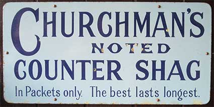
Here is an exhibition example of a similar sign:NOTED
COUNTER SHAG
In Packets only SOLD HERE'

The curious curlicued initial 'C' is simplified, making the brand name more readable. 'In Packets Only' is now accompanied by 'The best lasts longest'. In the modern times of tobacco advertising bans and an awareness and recognition of the deleterious effects of smoking on human health, these advertisements ring rather hollow. With the benefit of hindsight, the immense wealth accrued by the Churchman family was based on very dubious aspects of human activity: slavery on tobacco plantations, the pedalling of addictive drugs to young people and women and so on.
 1932
advertisement
1932
advertisementApart from the words 'PUSH THIS END' on the base of the cigarette pack, perhaps the oddest thing is the inclusion of a small swastika* between the words 'Cigarette' and 'Manufactured'.
[*The swastika is a geometrical figure and an ancient religious icon in the cultures of Eurasia, used as a symbol of divinity and spirituality in Indian religions. In the Western world, it was a symbol of auspiciousness and good luck until the 1930s, when it became a feature of Nazi symbolism as an emblem of Aryan identity and, as a result, it was stigmatized by its association with ideas of racism and antisemitism.
The name swastika comes from Sanskrit meaning 'conducive to well being' or 'auspicious'. In Hinduism, the symbol with arms pointing clockwise is called swastika, symbolizing surya (sun), prosperity and good luck, while the counterclockwise symbol is called sauvastika, symbolizing night or tantric aspects of Kali.]
The following is from the English Heritage Register of Parks and Gardens of Special Historic Interest.
"The Ipswich Chantry was founded in 1509 by Edmund Daundy, a prominent and respected Ipswich merchant [he was a Member of Parliament for Ipswich in 1512 and 1515, not to mention the uncle of Cardinal Thomas Wolsey]. After the Ipswich priories were suppressed in 1536, the Cutler family were said to be in occupation of a house at the Chantry and by 1668 the land was in the ownership of Sir Peyton Ventris. Sir Peyton was succeeded in 1691 by his son Edmund who built a house in about 1700 which is believed to be the foundation of the present house (Pevsner and Radcliffe 1975). Edmund died in 1740 and the estate was sold to Sir John Barker who made substantial improvements to the house. The Chantry changed hands again in 1772, being purchased by Metcalf Russell who added a further storey and passed the land on to his elected heir Michael Collinson. From 1795 onwards Michael's son Charles enlarged the estate to 500 acres (about 208 hectares) and it is he who was responsible for developing the character of much of the registered park which survives today (1998). He planted the South Avenue (1807) and made further modifications resulting in it being described as having woodland groves, a lake covering several acres and studded with little islands (dated 1828), and gardens of rare and exotic plants laid out with meticulous care (Kelly 1844).
In 1836 the estate was purchased by Charles Lillingston who married the daughter of the Rev Fonnereau of Christchurch Mansion and on the occasion of their daughter's fifteenth birthday the local paper carried a lengthy description of the park where the celebrations were held. Lillingston was attributed by White's Directory of 1844 as having made many improvements to the house and grounds. His son and heir however was killed in action, resulting in another sale in 1852 when Sir Fitzroy Kelly, a distinguished barrister and MP for Ipswich, became the new owner. Kelly is also said to have applied great energy to his new property, making many alterations to the house in the Italian style (White 1844). He commissioned the new gates and lodge at the north entrance and called in Mr Nesfield (assumed to be W A Nesfield (1793-1881) to provide a scheme for the flower gardens on the south front (Inspector's report). His stay was also short though, and he sold the site to Charles Binney Skinner in 1867. By 1897 the house and park had been sold again to Sir Henry Cecil Domville. The Domvilles lived lavishly in the Edwardian style but Sir Cecil died suddenly in 1902 and his widow went to live abroad. When the Jump family arrived in 1906 the grounds had become very neglected but Mrs Jump was a keen gardener and with the help of Mr Nottcutt of Woodbridge improved the gardens and added new features. In 1927 when the Chantry again came up for sale it was purchased by George Gooday with the intention of developing a housing estate. Sir Arthur Churchman, a JP and member of the Council intervened, however, purchasing the house and park and presenting them to the borough as a public amenity which was opened by Princess Mary in 1928. Since that time the house has been leased as a nursing home and the walled kitchen gardens are currently (1998) used as a nursery by the Borough Parks Department."
[UPDATE 3.1.2012: From Ronald Turner. "I was evaculated to (I think) Chantry hse in 1940 and I remember servants calling the owner Lord Woodbridge. It had a large lake and horses running in the fields.
I have been to suffolk several times to try and identify where it is but to no avail.
Could it possibly be Chantry Hse. ??
Yours sincerely RG.Turner"
Well, we know that Lord Woodbridge purchased the house and park in 1927 and gave it to the borough as a public amenity in the following year. It is possible that the house was used for evacuees during the 2nd World War - or another house in the estate. Can anyone help?]
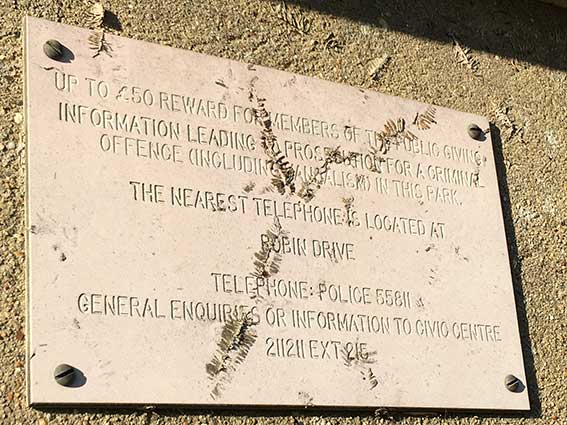
[UPDATE 13.12.2020: 'Earlier this week I spotted this sign on one of the posts on the London Road cricket pitch entrance to Chantry Park. It's very close to the 'Welcome to Ipswich' big brown sign. Judging from that five digit phone number and the reference to an extension number at Civic Centre, it's been there some time! I remember my parents first getting a landline and that having five digits, then the trauma of having to remember an extra digit. Wonder when that park sign went up? 1970s? Ed Broom.']
 Photograph
courtesy Ed Broom
Photograph
courtesy Ed BroomThanks to Ed for recording this. The sign was clearly once obscured by ivy, given the aerial roots still clinging to the surface. It's probably not worth anybody remembering it’s there, let alone unscrewing from the wall.
Let’s count up the redundant details on the notice:-
1. Nearest phone box (today, there doesn't appear to be a telephone box in the length of Robin Drive, there is one at the end (on Greenfinch Avenue next to the grocer and hairdressers) which appears still to have a phone in it;
2. Police station phone number (presumably the old headquarters block in Elm Street, now a car park);
3. Civic Centre and phone number. The first, long gone; the second presumably redundant.
So, triply misleading in 2020.
More park lettering: Alexandra Park, Bourne Park (and Bourne
Bridge) and Christchurch Park (and
Mansion).
See also our Lettered castings index page.
See also our Lettered castings index page.
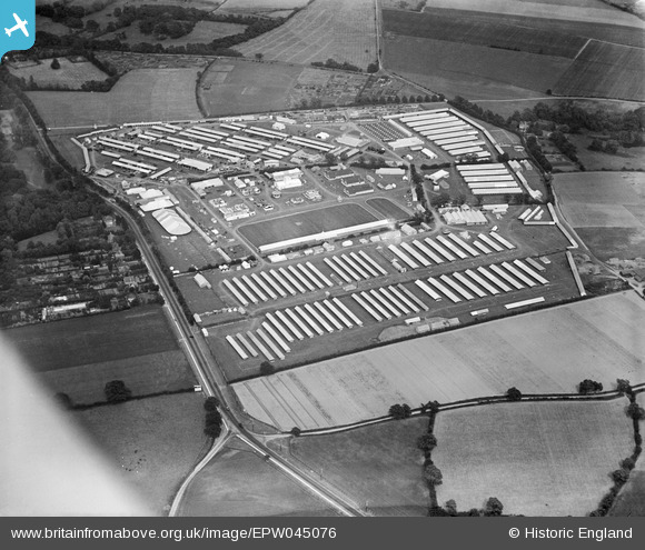
The Royal
Agricultural Show, 3 to 7 July 1934
 1934
image
1934
imageIn 1934 The Royal Agricultural Show was staged on 120 acres of farmland across the main road from Chantry Park. This was the forerunner of The Suffolk Show which in recent decades found its home on today's Trinity Park on Felixstowe Road. To get your bearings, the road running from bottom centre up towards the top left corner is the old A12 main road from London to Great Yarmouth (renamed the A1214 with the opening of the Orwell Bridge). The houses to the left of the main road are still there today and Chantry Park is just above them, only a small triange of woodland and grass visible here. The junction on this road towards the bottom of the photograph is Sprites Lane running off to the right; that to the left is Poplar Lane leading to Copdock and Washbrook. The building in trees just outside the show site at upper right is Stone Lodge Farm. In 1934 most of this area was cultivated farmland which is why the extensive showground could be sited here. One assumes that all of the structures and landscaping – tents, show rings, avenues, vehicle and pedestrain accesses and so on – were built from scratch and were disamantled and removed after the event. A sizeable part of the Chantry housing estate now occupies this site, built in the late 1950s and early 1960s, originally as an area of council housing.
The Souvenir Book
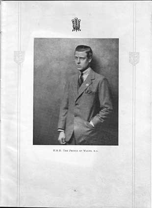
Interestingly, the first photograph in the souvenir book is a portrait of the great-grandson of Queen Victoria, Edward Prince of Wales who opened the Royal Show. In just eighteen months, on the death of his father George V, he would become King of the United Kingdom and the Dominions of the British Empire, and Emperor of India, from 20 January 1936 until his abdication in December of the same year. He caused a constitutional crisis by proposing to Wallis Simpson, an American who had divorced her first husband and was seeking a divorce from her second (the second decree nisi was, of course, granted in the Ipswich court (later County Hall in St Helens Street). A coronation never took place, Edward abdicated and was succeeded by his younger brother, George VI (known as 'Bertie' to the royal family, as featured in the 2010 fim The King's speech). With a reign of 326 days, Edward is one of the shortest-reigning monarchs in British history. After abdication, the pair were made Duke and Duchess of Windsor. In October 1937, the Duke and Duchess visited Nazi Germany, against the advice of the British government, and met Adolf Hitler at his Berghof retreat in Bavaria. The visit was much publicised by the German media. During the visit the Duke gave full Nazi salutes. The far right wing views of the Duke would cause problems for the British Government, so the Duke was appointed Governor of the Bahamas to keep him out of public view. The couple lived the rest of their lives domiciled in France. The constitutional crisis and controversy cast a long shadow.
One tiny trace of Edward's brief reign is the Edward VIII Ludlow wall-box on the old post office shop in Bawdsey.
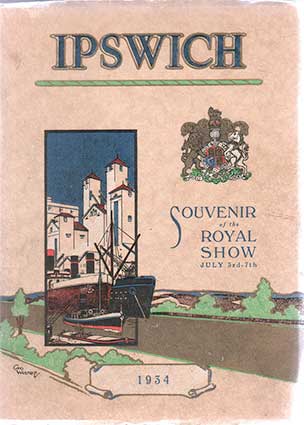 1934 book
cover
 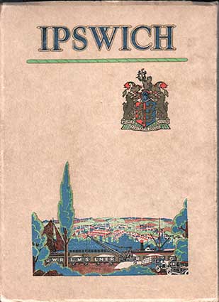 Back cover
The above substantial (168 pages)
book Souvenir of the Royal Show,
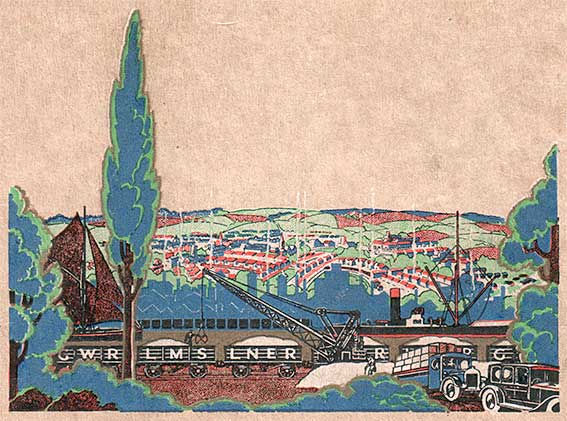
July 3rd - 7th ... 1934 is also examined on our page about the Borough coat of arms. The scene depicted on the
back cover bears a closer inspection. A rather generic collage of
Ipswich: industry, transport and coal fires putting smoke into the
atmosphere. Looking closer we see a saling barge and steamer on the
Orwell with the dock tramway in the foreground. The goods truck beside
the lineside crane is marked 'LNER' (London & North Eastern
Railway) which is the name of the main line through Ipswich (as shown
on the map below). Subtly rendered behind the shipping is a silhouette
in blue of the warehouses and maltings along the Wet Dock, then housing
and churches rise up the 'bowl' of the town. All in all, a very
attractive illustration by George Westrip in the block colour
separations of the period – much imitated even today in pastiche
illustration and advertising.
 Geo
Westrip illustration
 Geo
Westrip illustration
Geo
Westrip illustrationWe have used a selection of
interior advertisements for Ipswich businesses and
photographs from 1934 on other pages
on this website. The book was published by The East Anglian Daily
Times, 11 Carr Street ('issued by The Ipswich Industrial
Development
Association under official auspices'). There are two fold-out maps in
the book.
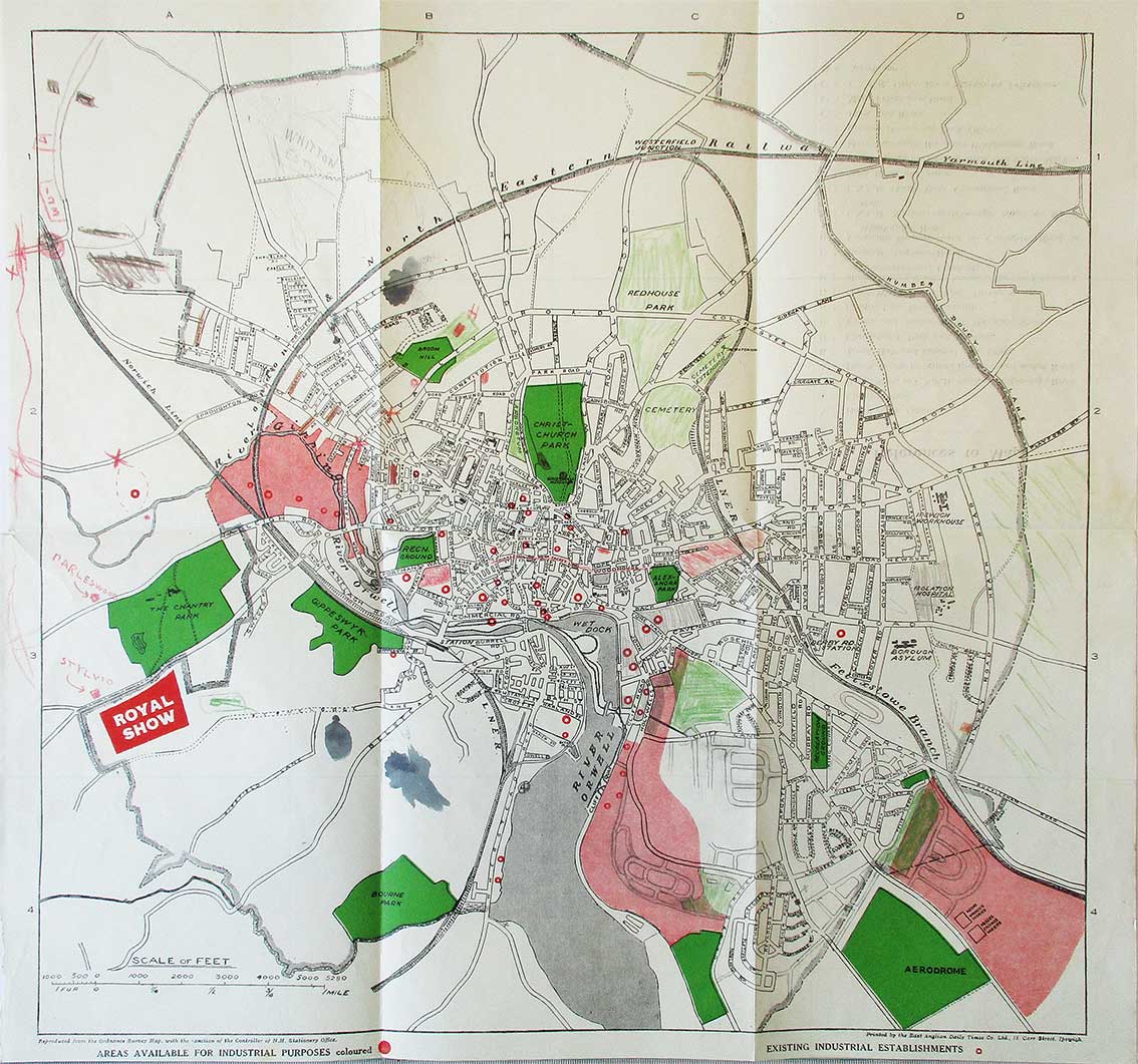 1934 map
The map in our copy shouts out the location of the Royal Show at the left, but bears the marks of age. Previous owners have added coloured pencil additions and there are several ink stains – fortunately not on important details.
 1934 map
The map in our copy shouts out the location of the Royal Show at the left, but bears the marks of age. Previous owners have added coloured pencil additions and there are several ink stains – fortunately not on important details.
- 1. The main public parks are marked in a strong green,
also the 'AERODROME' which has almost no buildings around it in 1934
and the area to the left which would later be called Pipers Vale. The
area we now think of Holywells Park has been shaded in by hand, because
it was still the private parkland of the Cobbold family in 1934. The
very next year, the land at Holywells was presented to the people of
Ipswich by Arthur Churchman, Lord Woodbridge and then opened to the
public in 1936, much of Holywells House was demolished in 1962 with
only the stable block and orangery remaining today.
- 2. Across Nacton Road from the Aerodrome are two square shapes: 'MESSRS WRINCH'S WORKS' and 'MESSRS CRANES WORKS': the Crane engineering site was quite small at this time.
- 3. The Borough boundary shown on this map by a long-and-short-chain dotted line was later moved quite a way along, but just south of Felixstowe Road and the adjacent rail way line to stop a few hundred yards short of The Shepherd & Dog public house and the 'The Shepherd & Dog Piggeries', the smell of which many will remember.
- 4. The red/pink coloured areas are labelled: 'Areas available for industrial purposes'. As if to drive the point home, 'Existing industrial establishments are show as a red 'O' shape peppered around the town.
- 5. Some additions have been made in pencil: 'WHITTON ESTATE' is roughly added at top left; the Rivers housing estate is added to the south of Cliff Lane with other post -934 roads drawn in.
- 6. To the north, someone has coloured in the 'CEMETERY' and 'CEMETERY EXTENSION' in green, but also the extent of 'REDHOUSE PARK' (as shown on our More almshouses page). One assumes that the public would have had access to this, the parkland and carriage drive of The Red House at this date; Cranfield Court almshouses would be built five years later, with more housing and roads.
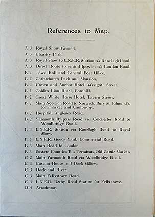 The
1934 map index
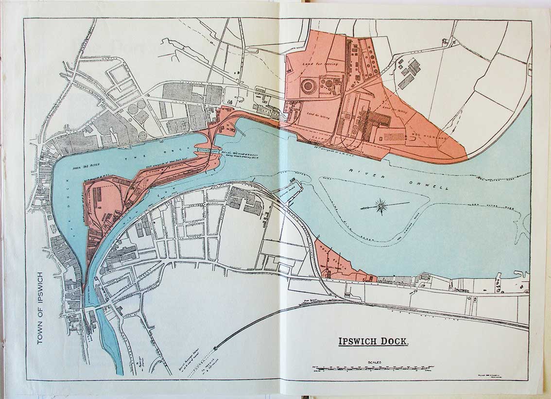 1934 Orwell map
To fit the fold-out format, the map of the river and Wet Dock is turned through 90 degrees in the book.
Over
Stoke map detail
Note that the area below the 'Griffin Branch Railway', along the riverside, is largely unindustrialised in 1934. The triangle of land, here coloured pink, is labelled 'Nova Scotia' – indeed, 'Nova Scotia House'; can clearly be seen abutting Wherstead Road with gardens reaching down to the Orwell. Across the river 'Hog Highland' is labelled. On the other side of the Griffin Wharf branch is the triangular site of the Cocksedge foundry, unlabelled; the company moved here in 1900, served by Rapier Street (also unlabelled here).
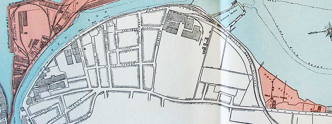
Note that the area below the 'Griffin Branch Railway', along the riverside, is largely unindustrialised in 1934. The triangle of land, here coloured pink, is labelled 'Nova Scotia' – indeed, 'Nova Scotia House'; can clearly be seen abutting Wherstead Road with gardens reaching down to the Orwell. Across the river 'Hog Highland' is labelled. On the other side of the Griffin Wharf branch is the triangular site of the Cocksedge foundry, unlabelled; the company moved here in 1900, served by Rapier Street (also unlabelled here).

- Moving to the left of Nova Scotia is Stoke Bathing Place with its enclosed swimming area (see more about this in our Water in Ipswich page). In tiny letters alongside 'West Road (New Cut West) is the legend 'Steam Boat Stages', indicating the regular steamer journeys from here (and after which The Steamboat Tavern is named).
- The Waterside Works of Ransomes & Rapier are next with a tramway linking to the Griffin Wharf branch line.
- Next comes the grid of residential streets leading off Wherstead Road, much of which is now radically different. Harland Street runs back from the Waterside Works, then comes Bath Street, Bright Street, Purplett Street, Tyler Street and Felaw Street.
- The horizontal streets shown here are Robinson Street (slightly staggered), Kemp Street and Hawes Street, which at that time linked Felaw and Harland streets.
- The reshaping of the roads in the 1980s, plus demolitions, resulted in Vernon Street (from Stoke Bridge) leading to a much extended Hawes Street. This made the town end of Wherstead Road an enclave – from Station Street up to the Uncle Tom's Cabin public house. Much of the housing and both Ransomes & Rapier and Cocksedge & Co. plus other structures were cleared.
©2004 Copyright throughout the Ipswich Historic Lettering site: Borin Van Loon
No reproduction of text or images without express written permission