 2013 images
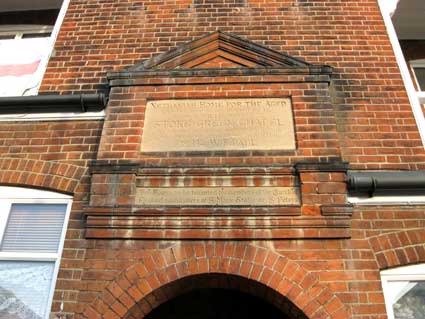
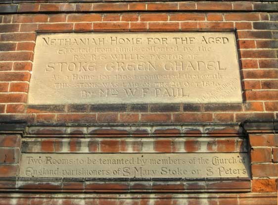
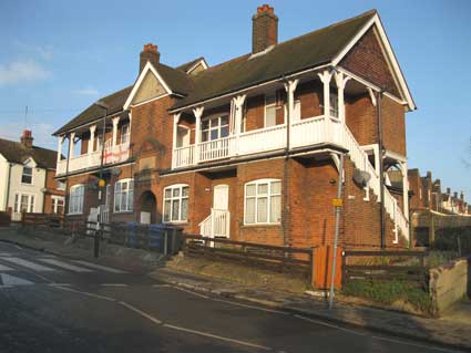
England parishioners of ST Mary Stoke or ST Peters'
Incidentally, Nethaniah is a personal biblical name meaning: “given of Yah.” Among others of that name was the son of Asaph who served in a company of prophets established by David. They issued their message with harps, psalteries, and cymbals.
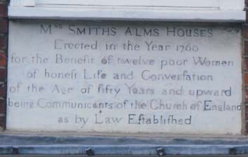
Mrs Smith's Almshouses, Elm Street
At 27 Elm Street, opposite Church of St Mary-at-Elms, is:
Erected in the year 1760
for the Benefit of twelve poor Women
of honeft Life and Converfation
of the Age of fifty Years and upward
being Communicants of the Church of England
by Law Eftablifhed'
 [Photograph
courtesy Mike O'Donovan]
[Photograph
courtesy Mike O'Donovan]This building is Listed Grade II: 'A mid C18 red brick building. 2 storeys and cellars. 7 window range, double-hung sashes with glazing bars, in flush cased frames. The windows are widely spaced in the facade. A central 6 panel door has a wood doorcase with moulded architrave, panelled reveals and a flat hood on brackets above a rectangular fanlight with vertical glazing bars. Above the doorway there is a panel inscribed with the words [shown above]. Roof tiled, with 2 square red brick chimney stacks. Church of St Mary at the Elms, No 1 Churchyard (St Mary's Cottage) No 25, Smith's Almshouses & Nos 29 to 33 (odd) form a group.'
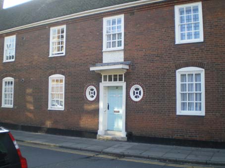
This ancient lettering compares with that on the Henry Tooley Almshouses in Foundation Street and the almshouses in Colchester. However, the buildings themselves are in remarkably good condition.
(Just a few yards down the road on the same side is a stone shield bearing the words 'Ipswich Board School'.)
The pleasant red-brick building houses eight well-appointed one-bedroomed flats with a garden behind. In 1720, Mrs Ann Smith, a widow of London, left £5,000 to be used for the benefit of ‘twelve poor Women, of honest Life and Conversation, of the Age of fifty Years and upwards, being Communicants of the Church of England as by Law Established’. The incumbent and churchwardens of St Mary-At-Elms are the trustees. The present almshouses, built in 1760, were refurbished in 2001. A celebration to mark the 250th anniversary of their foundation was held on Sunday June 27th, 2010.
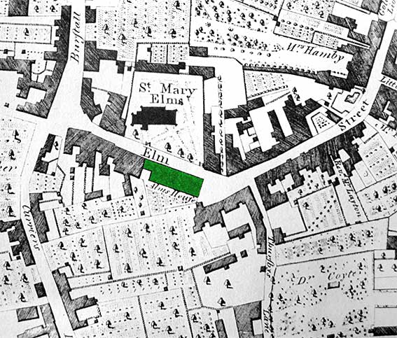 1778
map
1778
mapAbove: a detail from Joseph Pennington's map of 1778 showing, highlighted in green, Mrs Smith's Almshouses (labelled 'Alms House') stand in Elm Street opposite the Church of St Mary-at-Elms. On that page, see also the ancient cottages across the lawn (the churchyard) – seen here just north of the church. Just to the west of the church a large building, long gone, hems in the church; The Black Horse Inn is on the corner – a suggested birthplace for Thomas Wolsey. In 1778 Black Horse Lane was known as Burstall or Gaol Lane (as it led to the old West Gate to the town, part of which was used as a lock-up). Two other features to note here: Thursby's Lane dropping south from Elm Street towards Boat Lane (later Friars Street); this narrow street was eventually swallowed up by the development of Museum Street in 1847. Also, at bottom right, the Physic Garden of 'Dr Coyte', originally established by Dr Beeston (see Coytes Gardens).
ST. MARY ELMS, IPSWICH PARISH RECORDS
Book FB 104/L1/37
1756-1906
These documents are held at Suffolk
Record Office, Ipswich Branch
Supplementary information: See
Library Catalogues Ipswich 362.5 St Mary Elm
Contents:
Containing:- Copy of Anne Smith's will, 1756.
Copy of scheme for regulation of charity, 1756.
Copy of rules and orders for almshouses, 1759, made 1848.
Notice of opening of almshouses, 1765.
Elections of inhabitants, 1773-1889.
List of inhabitants of Mrs Smith's Almshouses, 1765-1906 extracted from
FB 104/L1/37
Plan of north front of Smith's almshouses in St. Mary Elms's
parish FB 104/L1/38 nd.. (18th century)
Plan; Smyth's Almshouses? FB 104/L1/39 n.d. (18th century)
Book containing copies of rules and orders concerning Smith's
Almshouses in St. Mary Elms parish FB 104/L1/40 1759
Smyth's Charity Account Book FB 104/L1/41 1778-1791
Statement of accounts of Mrs. Smith's Charity FB 104/L1/42
1802-3
Agreement between Benjamin Batley Catt and Trustees of Smith's
almshouses in St. Mary Elms FB 104/L1/43 1808
Envelope FB 104/L1/44 1766; 1828
Draft instructions FB 104/L1/45 1833
Part of final concord FB 104/L1/46 16th century
(NB: There is mention in adjacent documents of: "Bundle of papers concerning legacy for almshouses made in Mrs. Ann Smyth's will in 1729".)
See our Museum Street page for larger 1778 and 1902 comparative maps including this location.
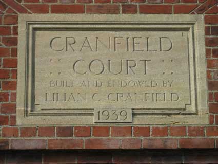
This array of buildings fronts the (very) busy Tuddenham Road roundabout and boasts an attractive brick entrance gate with a lettered tablet.
 2013
images
2013
images
COURT
BUILT AND ENDOWED BY
LILIAN G. CRANFIELD
1939'
The Red House
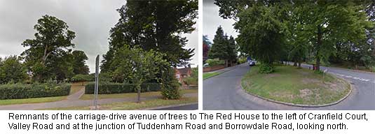
Next door to the Cranfield Court complex on Valley Road is a 'pocket park', in contemporary parlance, which has a row of mature trees on each side. This is the remnant of the carriage drive to one of the lost country houses of Ipswich, The Red House, here marked 'Redhouse Park'.The double row of trees, broken by the Ipswich bypass, continues southwards to the Borrowdale Road junction. From above, the line of the drive cuts through the much more recent Chelsworth Avenue/Bromeswell Road housing development with a track on the same line going across a field, passing to the west of Red House Farm. This latter remaining vestige of the Red House estate is accessed by a straight, narrow lane off Tuddenham Road, before the bridge over the Felixstowe Branch Line. The Red House, belonging to the Edgar family, is thought to have been built in the mid-17th century; two wings were added later. It was an imposing three-storey building with a columned central entrance. It was finally demolished in 1937 to make way for housing. This suggests that it stood between the two residential roads mentioned here.
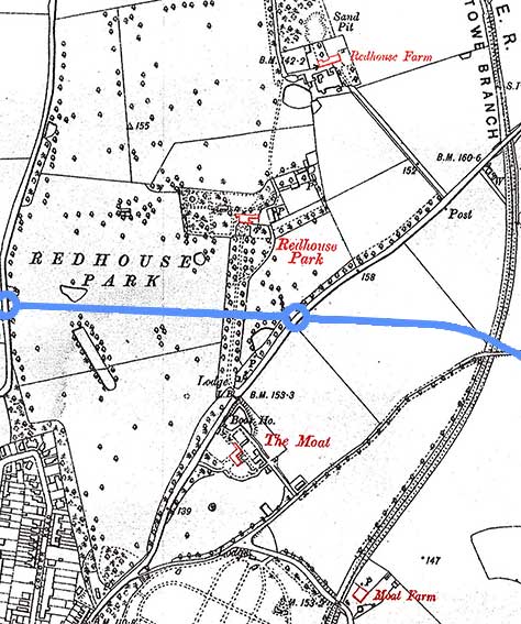 Early
1930s map
Early
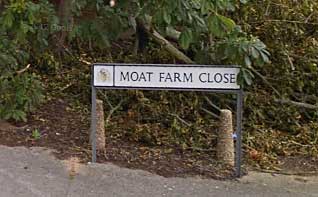
1930s mapThe early 1930s map detail above shows the area before the building of the Valley Road/Colchester Road by-pass (approximate position shown in blue). The avenue of trees leading to the front of Redhouse Park stretches down to another lost Ipswich house, The Moat, which has a lake/moat and Boat House marked close to Tuddenham Road. Bottom centre of the map shows the old cemetery with Brunswick Road curving round it to meet Tuddenham Road. The triangular junction with today's Cemetery Lane is clearly visible. This led up to the main entrance to The Moat and continued north-east to cross over the railway – the rail bridge in 1930 appears to be at the wrong angle for the bridge carrying the later bypass, so it seems that the bridge was rebuilt at the better angle and Cemetery Lane diverted to meet the by-pass at a T-junction, as it does today. Before the bypass (and the railway) the line of Cemetery Lane would become today's Sidegate Lane West, running past Northgate High School to meet Humber Doucy Lane. Brunswick Road leads eastwards to cross the railway to the location of Moat Farm. Today, this is the site of the modern housing group of Moat Farm Close. The elongated triangle formed by the railway, Brunswich Road and Cemetery Lane was to become the 'new cemetery and crematorium.
 2017
image
2017
imageTo the north and a hundred yards or so short of the Tuddenham Road bridge over the Westerfield-Felixstowe branch, the straight drive down to Red House Farm is obvious, still in use today. The west boundary of the whole 'Redhouse Park' is marked by the north-south Westerfield Road seen to the left. In 2017, this whole area of farmland is marked for the large 'Northern Fringe' housing development, known as 'Ipswich Garden Suburb'.
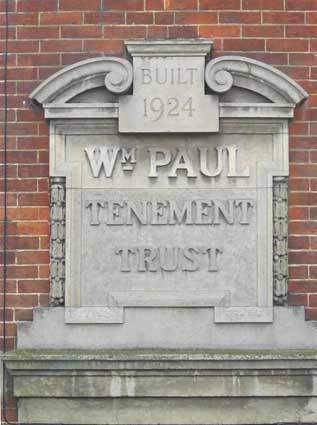
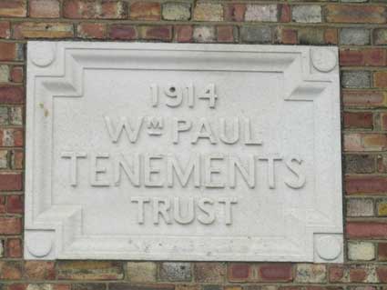
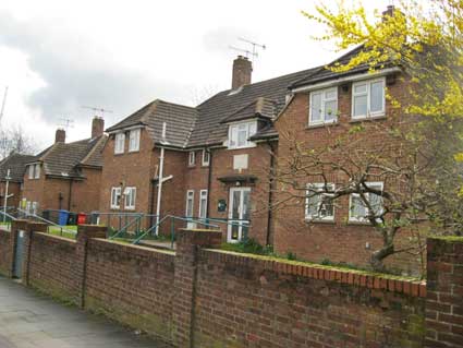
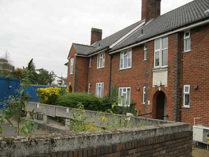
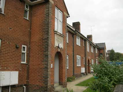
This example in Back Hamlet is so easily missed that it counts as 'one that got away'. This is particularly so given that it was not until 2013 that we got round to including the trust's plaque in Felaw Street, even though we knew it was there. The 1924 terrace of houses sits low down behind a hedge in Back Hamlet, so you need to be on foot or bicycle to notice it:
1924
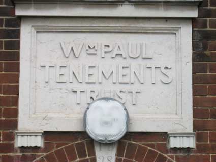
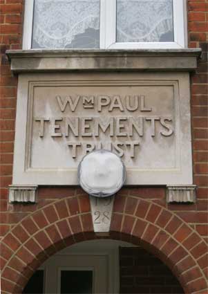
WM. PAUL
TENEMENT
TRUST'
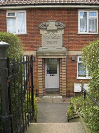
 2013 images
William Paul proves quite elusive on internet searches, but William Paul II (as he is more correctly known) and his brother Richard Paul II must be the 'R&W Paul Ltd' to be found on the remaining silo near the Trinity House buoy on Stoke bridge. R&W Paul Ltd were incorporated in 1893. This information is taken from The British Malting Industry Since 1830 by Christine Clark:-
William Fraser Paul (1850-1928)
"On the one hand, he was ambitious and forward-looking … ; a self-made man, he preached the values of personal effort. On the other hand, the harshness and pace of life clearly repelled him. He valued his long-serving and loyal workforce, 'my old servants and fellow helpers in business', and sought to reward them. From an early age, he was active in civic life; a justice of the peace, member of the Ipswich Dock Commission, the Museum and Library Committee and a Trustee of Ipswich Municipal Charities. A staunch Liberal, he served as town councillor (1890-1908), alderman (1909-28) and mayor (1900-1). Notably, during his term of office, he refused to participate in the ceremonies or services of the established church. Wealth brought comfort, not personal extravagance; a growing involvement in agriculture – by the turn of the century he was farming at Freston and Kirton; and a commitment to improve the welfare of the town's citizens. For many years chairman of the public health committee, he instigated the public refuse system and TB sanatorium. For his work at Broadwater, an auxiliary hospital for wounded servicemen which he donated and also administered for the duration of the war, he received the OBE and the Order of St John. In 1914 the William Paul Housing Trust built its first tenements for the poor and aged. Shortly before his death he created Bourne Park in one of the most densely populated districts of the town. His obituarist, with much justification, described William as the greatest benefactor in the history of Ipswich."
A close run thing with Felix Thornley Cobbold, perhaps. W.F. Paul's name crops up in relation to the Girls Ragged School, Rosehill Library and, as mentioned in the passage above, Bourne Park.
See our Paul's malting page for the story of the company and its importance to Ipswich.
"The Trust has 80 [emphasis by this website] sheltered dwellings in management to meet the prime objective of providing Almshouse accommodation for the poor and elderly in the Ipswich area." Although this is the grandest carved tablet of its kind we've found, other examples of the Wm. Paul Tenement Trust can be found in Stoke Street, Felaw Street and Black Horse Lane.
Compare with the rather more upmarket but similar style of naming: Norfolk House. (A few yards down the hill from here is Trinity Lodge.)
WM PAUL
TENEMENTS
TRUST'
For surrounding streets including the nearby Maltings Terrace, plus the story and maps of Felaw Street and environs, see our Felaw Street page.
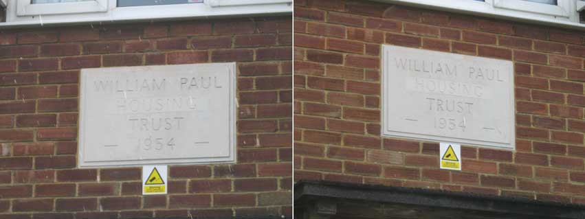
1-8 Stoke Street
HOUSING
TRUST
-1954-'
Black Horse Lane
Our researches have thrown up a similar Ipswich image on Flickr; it took a while to track it down. It turns out that we'd walked past it many times before. Firstly, follow Black Horse Lane round to what used to be the rear of Civic Centre:
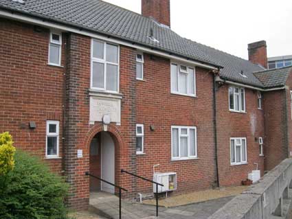
TENEMENTS
TRUST
1928'
A similar tablet and dated keystone (also the intrusive modern floodlight) can be found above the central entrance facing the rear of the Methodist Church in Black Horse Lane.
Cliff Lane Almshouses
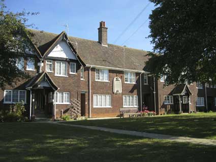 2013
images
2013
imagesSimon Knott of this parish describes these as 'Cobbold Brewery almshouses, Cliff Lane, Ipswich' and who are we to question it?
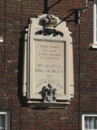
were erected
by Public Subscription
AS A MEMORIAL
TO
HIS MAJESTY
KING GEORGE V.
1938
AND WERE OPENED BY HIS SON
H.R.H. THE DUKE OF KENT
K.G. K.T.'
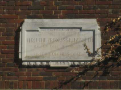
The tablet on the more recent extension to the left is more eroded:
WAS ERECTED BY PUBLIC SUBSCRIPTION
AS THE WEDDING GIFT OF THE PEOPLE OF IPSWICH
TO
H.R.H. THE PRINCESS ELIZABETH
ON THE OCCASION OF HER MARRIAGE TO
H.R.H. THE DUKE OF EDINBURGH
IN NOVEMBER 1947
IT WAS OPENED BY
H.R.H. THE DUCHESS OF KENT
1949'
See also Tooley Almshouses in Foundation Street. More almshouse lettering can be found in Colchester.
©2004 Copyright throughout the Ipswich Historic Lettering site: Borin Van Loon
No reproduction of text or images without express written permission