Ipswich station and Westerfield-Felixstowe
Branch Line
These
photographs by Richard Casserley (RMC) – with some by his father,
Henry Casserley (HCC), also a noted photographer of railways –
date from the 14.5.1956, unless shown. (See also Richard's accompanying
set of the Saxmundham to Aldeburgh
branch line). Notes to the photographs by the
photographer in italics.
Ipswich Station exterior
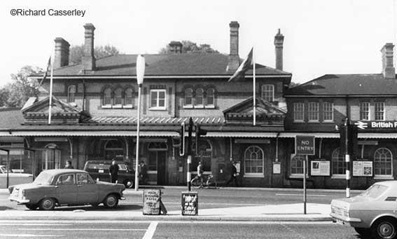
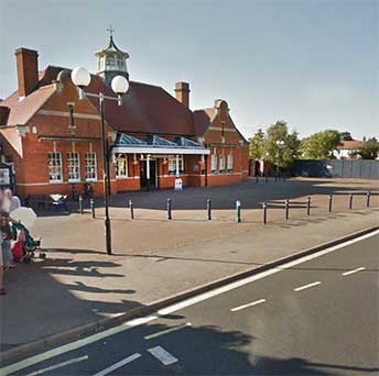
1. Ipswich station exterior, 7/6/69
(HCC).
Ipswich station was re-sited to its present location in 1860 and the
main building was thought to be principally the work of Peter Bruff;
who had certainly started the structure. See our EUR
page for the site of the original station in Over Stoke, prior to the
building of Peter Bruff's curving tunnel through Stoke Hill. The actual
design was in the Italianate style and submitted by architect Sancton
Wood (1816-1886) as part of a competition. When the new station was
completed, a new road (Princes Street, originally 'Railway Station
Road') linking the station to the town was also opened. Originally the
station did not have the island platform which provides platforms 3 and
4. For the lettered ironfounder's plate on the footbridge
(probably 1883), see the bottom of our Princes
Street page.
Platform 1 is a bay platform for trains to/from Lowestoft and
Felixstowe.
Platform 2 is used for through-trains to London from Norwich as well as
some Felixstowe services.
Platform 3 is used for through-trains to Norwich from London as well as
some Cambridge services.
Platform 4 (4A, 4B and 4C) is used for services to Cambridge and
Peterborough, and stopping services to London.
From 2015 to 2017 major reshaping of the station buildings took place
to introduce a new, larger booking hall with seating and new retail
spaces.
Local list
The station buildings appear on Ipswich Borough Council's Local list:-
'2 storey central block with single storey ancillary stores and
offices, designed by Robert Sinclair, Locomotive Superintendent &
Engineer to Great Eastern Railway. Built in Suffolk white brick with
triple brick arched entrances – string course, cornice and window
surrounds to main building all in red brick. Windows are a notable
feature – 11, 9 and 2 light sashes under rubbed red brick arches.
Double brick pediment to each side of main entrance (at first floor
level). Boarded canopy to street elevation with original decorated cast
iron bracket supports. Main platform (no.2) modernised but No.3
platform (on island
built in 1883) retains original canopy with saw tooth roof line and
ornamental boarded gable ends facing track, again with original cast
iron supporting structure. Island building – similar in detail to main
block.
A blue plaque is positioned adjacent to the entrance, dedicated to
Peter Bruff, the engineer behind the railway line and the tunnel at
Stoke Hill, often regarded as the Brunel of Ipswich.
Included for architectural value as a prominent, well detailed and
attractive station building, designed
by Robert Sinclair of Great Eastern Railway; historic value
illustrative of the engineering achievements of the period which
brought the railway to the town; landmark value as a prominent building
with long street frontage which welcomes passengers to Ipswich;
associative value with Peter Bruff; group value with The Station Hotel
and the group of 19th century residences along Willoughby Road which
developed around the station, all included on the Local List.'
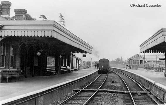
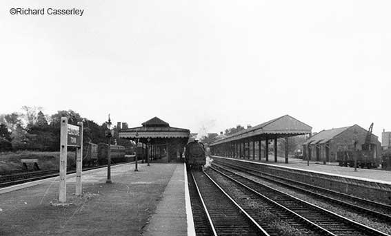
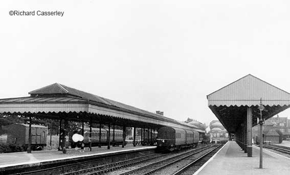
Ipswich Station trackside
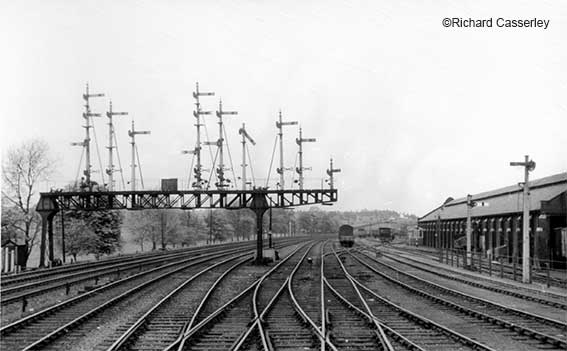
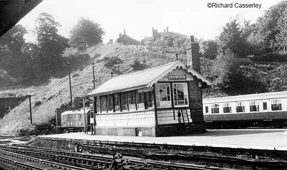
2. Ipswich; 14/5/56 (RMC). With semaphore array.
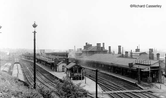
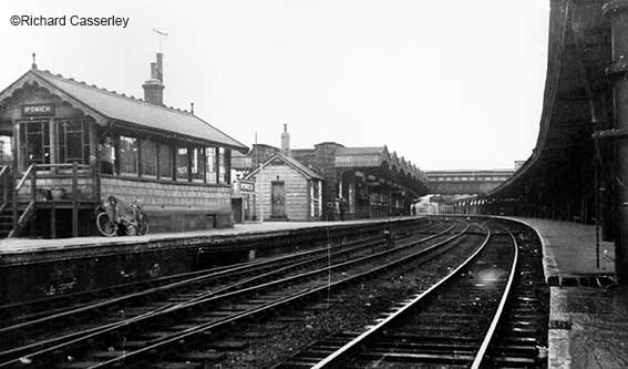
3. Ipswich station; 14/5/56 (RMC). Facing north.
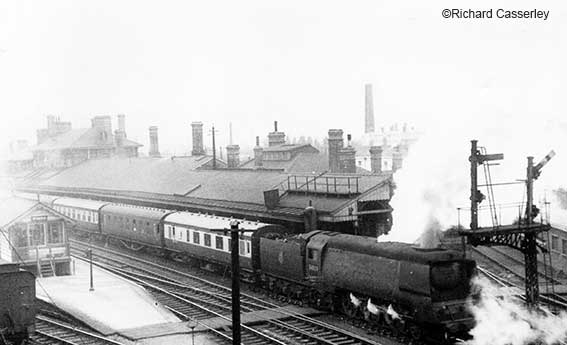
4. Ipswich station; 1/9/51(HCC). 34039 on the 14.38
Lowestoft-Liverpool
Street – see detailed note
below.
5. Ipswich station; 7/6/69 (HCC). The tunnel entrance through
Stoke Hill is to the left.
"The 'West Country' class loco was built at the Southern Railways works
in Brighton and entered traffic on 16th September 1946 in full Southern
malachite green livery. It worked trains principally from London
Victoria station to the Kent coast resorts of Margate and Ramsgate and
the ports of Folkestone and Dover. It received the name
“Boscastle” some time between 1947 and 1948. After
nationalisation in 1948 “Boscastle” received the number 34039 and
between July and September became the regular engine on the prestigious
Golden Arrow Pullman train.
In November, 1948 “Boscastle” moved to Brighton shed, and began working
to such places as Salisbury, Bournemouth and Southampton. Other duties
included late night trains, parcels trains from Brighton to London,
returning on the early newspaper train from London Bridge. “Boscastle”
became the first 'West Country' class locomotive to carry the new
standard British Railways passenger green livery in August, 1949.
In 1951 Brighton’s allocation of West Country’s were dispersed
elsewhere and “Boscastle” was chosen, along with two others for trials
on the Eastern Region in May. Based at Stratford shed (London) they
worked services from Liverpool Street to Cambridge, Norwich and
Harwich. During this time “Boscastle” visited Bury St Edmunds (where it
was too long for the 50' turntable) and Doncaster, presumably on a
special working. This was when BR were testing various locomotives on
different lines, whilst formulating the'standard' class engines which
could work over the entire network. There were many advantages to this,
including common spare parts and economies of scale.
The trial was not a great success due to the crews’ unfamiliarity with
this type of locomotive and the problems of getting fitters and spare
parts across London when they required attention. “Boscastle” returned
to Brighton in March 1952. Why the name is not on the loco in the image
will remain a mystery, I guess, but it cannot have appeared many times
at Ipswich in the 12 or so months it was on the old GER.
It is currently being restored for a second time in its life at the
Great Central Railway in Loughborough." [Notes from Great Central
Railway, www.gcrailway.co.uk/the-railway/locomotives/34039-boscastle]
6. Ipswich station, 14/5/56 (RMC). Facing north. The
signal box on the island platform.
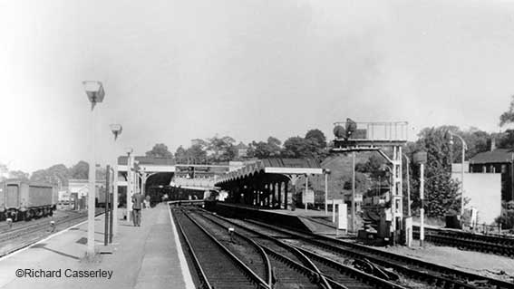
7. Ipswich
station, 9/6/69(HCC). Facing
south.

8. Ipswich, 14/5/56 (HCC). With
early diesel shunter 11136.
Westerfield station
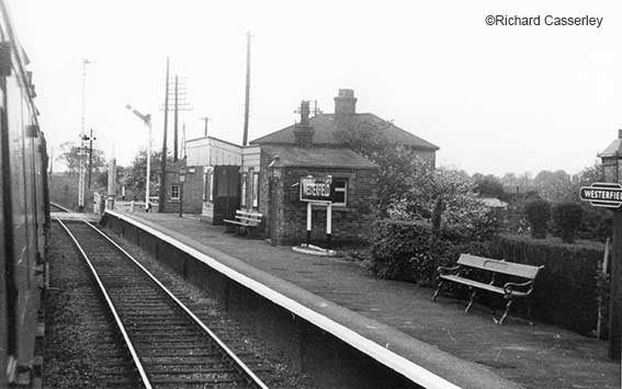
9. Westerfield station, 14/5/56 (RMC). Facing
Ipswich.
Westerfield station building is situated on the southern side of
the
East Suffolk Line. There were two through-platforms when the station
opened and these were supplemented by two further bay platforms when
the Felixstowe Branch Line opened in 1877. The Felixstowe Railway
Company had offices on the southernmost platform which are still extant
today as a private residence after the building had stood derelict for
many years. The goods yard was situated on the northern side of the
line and consisted of a couple of sidings accessed by setting back from
the main line. Westerfield junction lies a short distance to the east
of the station.
To the west of the station and level crossing there was the start of
the Dales
brickyard light railway (1.5 miles long). In World War I this line
was requisitioned by the government to serve a munitions depot in the
Upper Dales. In 1921 the line was worked by a Garrett steam road
tractor as the track was in poor condition and it was removed in about
1927.
The original signal box was situated at the east end of the Lowestoft platform but this was replaced by
a standard Great Eastern structure located at the junction for the
Felixstowe branch. The box survived as the Felixstowe branch still had
conventional block signalling with the next box being at Derby Road
albeit with a large modern radio mast inelegantly attached to a
Victorian structure. The box finally closed when the signalling was
upgraded in 1999 and the area is now controlled by Colchester Power
Signal Box.
See also our Cavendish
Street page for a large map detail from 1867 of the eastern part of
Ipswich pre-Felixstowe Branch Line railway, where a
'Proposed' St Helens Road would (somehow) have crossed Spring Road
around the same place as today's railway viaduct.
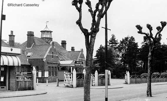
Derby Road station
10. Ipswich Derby Road, 14/5/56 (HCC). Facing Felixstowe.
Above: the two remaining stations on the Felixstowe branch line.
Derby Road is a small station
serving the Victorian suburbs of St John's and Rosehill. In the 21st century it is
in a sad state, devoid of a canopy and with the station buildings
closed up and abused; it needs some investment. The line is doubled
here to allow passing of freight and passenger units on this largely
single-tracked line (the line is also doubled at Trimley station).
Orwell station
George Tomline (1813-1889), referred to as Colonel
Tomline, was an
English politician who served as Member of Parliament for various
constituencies. He was founder and Chairman of the Felixstowe Railway
and Pier Company which built the Felixstowe Branch Line (which was
opened on
1 May 1877) and established the Port of Felixstowe. This had been
promoted by Tomline who was criticised in the Suffolk Chronicle for building the
stations where he "thinks people ought to be, rather than where people
actually live". This was especially true of Orwell station which was
situated close to Tomline's home at Orwell Park, as shown on the 1946
map below. Tomline Road in Ipswich (see Street
name derivations) commemorates the man. Our Rail bridges page has more on the route of
the Felixstowe line from Ipswich with a link to a 1930s map.
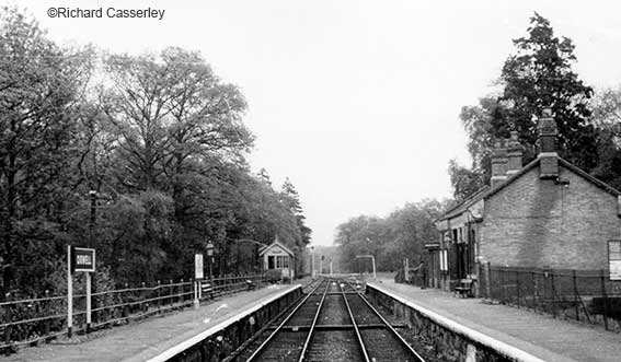
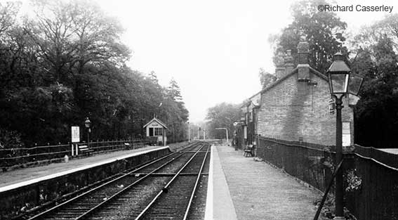
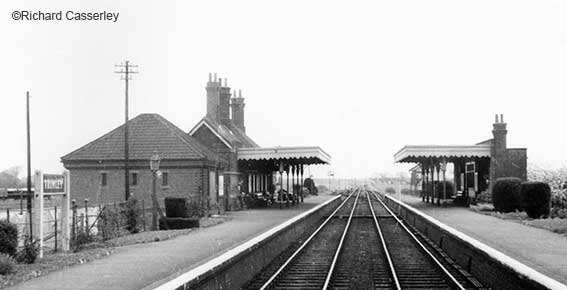
11. Orwell station, 14/5/56 (HCC). Facing Felixstowe
12. Orwell
station, 14/5/56 (RMC). Facing Felixstowe.
Sadly, Orwell Station no longer exists as
such. It was,
understandably,
commissioned by Colonel Tomline when his company had the branch line
built to
link Felixstowe Pier (and the putative dock) to the main line at
Westerfield Junction. The
station served as the Colonel's personal station for his mansion,
Orwell Park, which is today a public school. One assumes that villagers
in Nacton had the luxury of their own station on the branch line.
Orwell
opened on the same day as the branch line, 1 May 1877 and closed
on 15 June 1959, although the line
through the station remains open. On 1 September 1879 the Great Eastern
Railway (GER) took over operation of the line, although the Felixstowe
company retained ownership until 5 July 1887 when it sold the railway
to the GER. This in turn formed part of the London & North Eastern
Railway in 1923 and then the Eastern Region of British Railways in 1948.
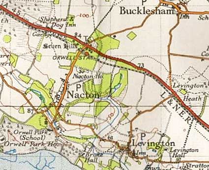 1946 map of
Orwell station
1946 map of
Orwell station
The River Orwell can be seen at the bottom of the 1946 map (above) with
'Orwell Park (School), Orwell Park Ho.' The old A45 main road to
Felixstowe runs west to east just north of the station. Presumably,
During World War II an armoured train with a 12 inch (300 mm)
Howitzer was stationed on the line with a modified Class F4 locomotive
to power it. It was initially based at Derby Road but soon moved to
Orwell. It patrolled lines in the area and sidings were provided for it
at Levington and Trimley.
An accelerated diesel-powered service was introduced on the line on 15
June 1959. The little-used Orwell station was closed to help reduce the
time taken for a journey between Ipswich and Felixstowe Town from 35 to
24 minutes. This allowed a diesel multiple unit to work out and back
within an hour. At the end of the year it was reported that the new
service had increased the number of passengers carried by 70%. The
former station building became a private residence.
Orwell station was located at Milepost 78 which is 9.3 miles
(15.0 km)
from Ipswich, just to the east of Orwell level crossing. The station
was the only passing place for trains when the line opened in 1877,
with a platform for each track. The station building was on the
westbound platform. A goods siding was situated behind this and was
accessed from the Felixstowe (eastern) end.
Trimley station
13. Trimley - facing
Felixstowe
14/5/56 (HCC). The attractive Trimley Station (specifically Trimley St
Mary, but close to Trimley St Martin) in 1956, with its
platform canopies on the up and down lines, is a very different place
in the 21st century with weather entering through a collapsed roof. A
fund-raising group, Trimley Station Community Group
(www.trimleystation.org), tells us of its history:-
'The original railway line for passengers from Westerfield to
Felixstowe was opened by the Felixstowe Railway and Pier Company in
1877. Great Eastern Railway (1862-1948) purchased the line in 1887 and
built stations at Felixstowe Town and Trimley St Mary. Other stations
built by the G.E.R. included Beach Station (demolished), Orwell Station
(demolished) and Derby Road in Ipswich. The line is now served with
diesel railcars for passengers to Felixstowe and Freightliner traffic
for the Port of Felixstowe branch line.
Trimley Station was opened on 1st May 1891 and pre-dates the Town
Station at Felixstowe by seven years. The station was built in an
attempt to generate good quality commuter travel into Felixstowe. It is
likely now to be the only surviving country station built by the former
Great Eastern Railway in Suffolk.
Trimley station was built in a 'speculative' version of the New Essex
style – one of only two examples to be built outside Essex. The Chief
Architect of the Great Eastern Railway, W N Ashbee, was the author of
this design and the buildings became known as in the 'Ashbee style'.
Ashbee was also the architect of the Town Station in Felixstowe (1898),
now Listed Grade II.
The interior of the station would have comprised originally of a first
class waiting room, porter's lodge with first class lavatory behind,
booking office, combined booking hall and general waiting room and
ladies' room with lavatory en-suite.
The booking office at Trimley St Mary was closed in 1967. A passenger
footbridge survives along with the Gatekeeper's House adjacent the
crossing at the Station. The original Break Goods store is also extant.
What may have been the Stationmaster's House also survives and has been
extended. An associated signal box was demolished in 1988. A smaller
passenger building formerly on the opposite side of the platform (the
up platform) has been demolished (date unknown).' The line is doubled
here and at Derby Road station in east Ipswich.
Felixstowe Town station
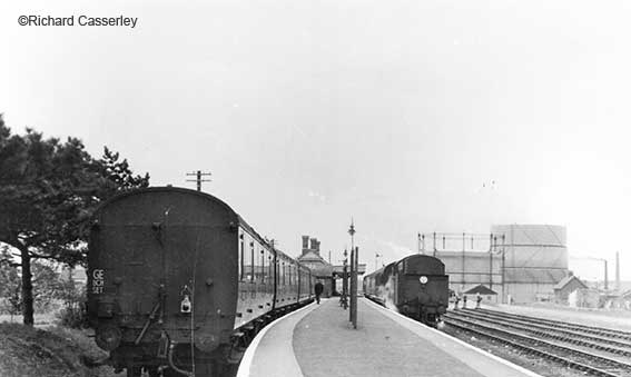
14. Felixstowe Town station, 14/5/56 (HCC). 67739 with the 12.45 to Ipswich.
15. Felixstowe Town station, 14/5/56
(HCC). 67702 with the
14.00 Felixstowe Beach-Ipswich.
 2017 image
16. Felixstowe Town station exterior,
from Hamilton Road, 14/5/56 (HCC). Note the central
lantern. 16a. The modern view of the
original station building (now shops)
with earlier fencing, gates and trees removed.
Felixstowe Beach station had been the original stop for the
seaside resort (see below for more detail). The rather fine building
shown here was designed by J. Wilson and the Chief
Engineer and Architect of Great Eastern Railway, W.N. Ashbee***, in the
domestic revival style using red brick
with stone dressings and a pantile roof. It was opened by the Great
Eastern Railway (GER) on 1 July 1898 by Lord Claud Hamilton, the
chairman of the railway company, as the more convenient Felixstowe Town
railway station on Hamilton Road. Since 1967 it has been the only
station in the town. The station buildings were Listed
Grade II on 23 December 1980.
[***Some sources attribute the station design to Thomas W.
Cotman, as discussed on our Felixstowe
page under '33 Hamilton Road, Lloyd's Bank'.]
A new 'Orwell Hotel' was opened in 1898 opposite the station
entrance. More hotels opened in the town around this time including the
luxury Felix Hotel on the sea front in 1903 which, in 1919, was
purchased by the GER and operated as a railway hotel until it was sold
in 1952 (today it has been converted into 'Harvest House':
apartments for the over 55s). A promenade was built along the seafront
in 1903 and a pleasure pier opened in 1905. Lord Claud Hamilton was
invited back to the town in 1909 to open a new Spa Pavilion, where
visitors took the waters. The developing resort was by now served by
direct trains from London Liverpool Street station. In 1905 the 10.00
service from London (which had been introduced the previous year as a
non-stop service to Lowestoft) called at Westerfield to detach
carriages for Felixstowe. It was only allowed two minutes to do this
(reduced to a single minute in 1908), and the Felixstowe portion
continued on its way just three minutes later. A non-stop train each
way between Liverpool Street and Felixstowe Town was introduced in
1906. Another fast train was introduced in 1907 with a single stop at
Colchester.
Felixstowe Beach station, the
original seaside town station
17. Felixstowe Beach station, 14/5/56
(HCC). Facing pier –
67739 with 12-45 to
Ipswich.
Although the Felixstowe branch line and Pier opened on 1 May 1877,
there were no stations between Orwell and the terminus at Felixstowe
Pier as the station near the beach at Felixstowe was not ready in time,
although it did open soon after. It has been claimed that Colonel
Tomline chose this location to be away
from his rival
John Chevalier Cobbold's Ordnance Hotel, which was close to the railway
on Garrison Lane. A few yards in front of the hotel were the remains of
a redout, with several of the gun emplacements intact; it was probably
from this fortification that the Ordnance took it's name. Ironically,
perhaps, after 150 years the Ordnance Hotel on Garrison Lane was
demolished in 2014 to make way for a Premier Inn. Originally it had
been a popular drinking-place for the navvies who built Felixstowe
Port. They would leave their work on pay day to row up a navigable
creek – the remains of which border nearby Langer Park – to reach the
hotel and spend their hard-earned cash. The Beach station originally
had goods facilities and also the line's engine shed.
The Great Eastern Railway (GER) bought the line on 5 July 1887. The
engine shed was soon closed but the site is believed to have been used
for coaling and watering of locomotives for some time after. Eventually
this was undertaken at Felixstowe Town station which was equipped with
a turntable. There was a large three-road shed adjacent to the engine
shed and in 1894 a carriage-painting facility was opened which dealt
with the painting of around 200 carriages each year. This was a
relatively short-lived activity at Felixstowe as the expansion of
facilities at Stratford Works in the late 1900s would have rendered the
establishment unnecessary. It was noted as redundant in 1927 when it
was identified for use as the line's engine shed (the original having
blown down) but it burnt down in the 1930s.
The Beach station was enlarged in 1888 but a new and more
conveniently-sited Felixstowe Town station (shown above) opened on 1
July 1898. The original station was renamed 'Felixstowe Beach' and the
direct line from Ipswich was closed with the result that all trains now
had to reverse in the new station. Passenger trains beyond the Beach
station to Felixstowe Pier were withdrawn from 2 July 1951. The
low-lying area around the station was inundated by a fatal flood on 1
February 1953.
Ceremony photograph. It was
not until 1970 that a direct line from the
Westerfield end to Felixstowe Dock was reinstated (a remarkable
photograph
of the reopening of the link to the dock was found on the Let's talk 24 website – sadly no
longer viewable:
http://www.letstalk24.co.uk/wp-content/uploads/2014/04/FLXPST-rail-1024x671.jpg)
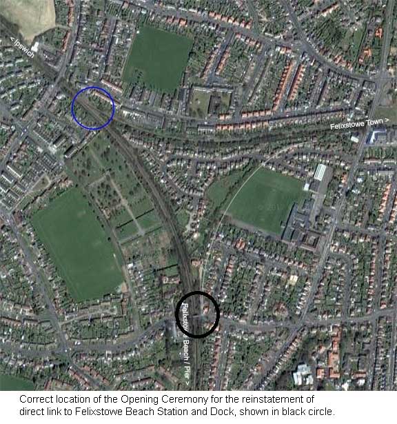 Courtesy
Jim Bloomfield
Courtesy
Jim Bloomfield
Above: the modern aerial view shows the three curving
lines of the
triangle; the pale grey curve emphasises the track from the Felixstowe
Town station southwards towards the docks (now dismantled), which is
identifiable by a
hedge line. The blue circle was thought to be the site of the opening
ceremony in
1970 when the direct line to the docks was reinstated. However...
[UPDATE 13.10.1027: 'I refer
you to the webpage mentioned above and wish to point out that you have
given some incorrect information in relation to the location of the
opening ceremony for the reinstatement of the direct link
to Felixstowe Beach Station and the Dock. The ceremony actually
took place at the Southern end of the triangle. I have marked the
location on the same map picture that you have used.
I think the photographer in the (Let's talk 24 website) ceremony
photograph stood to the side of the Mill Lane bridge,
most probably on the footpath that runs beside the cutting
connecting Mill Lane with Grange Road. The
bridge shown was
demolished several years ago when the cutting was filled in. I believe
the bridge originally connected Newry Ave to the District Council
depot that grew plants for use in the Council gardens, roundabouts
etc. in the Felixstowe area. There were also allotments, I believe, on
the Triangle. There is actually now a house built on the corner of the
original cutting. The reason I know so much about this
area is that I was born and raised
quite nearby and went on to the railway as a driver based at
Ipswich for 38 years; I have always had a special interest in the
Felixstowe Branch. I hope you
find this information of use and correct your webpage accordingly.
There are some fab photographs on there detailing the
history of the
Branch line. Jim Bloomfield. Many
thanks to Jim for solving this problem of the ceremony location.]
18. Felixstowe Beach, 14/5/56 (HCC). Facing
pier – 67739 with 12.45 to
Ipswich. 19.
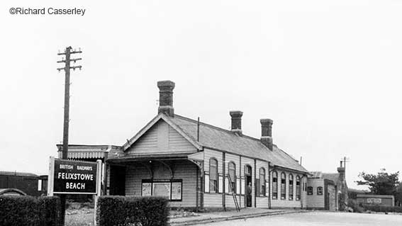
Felixstowe Beach station exterior, 14/5/56 (HCC)
Felixstowe Beach is situated at the bottom of the gradient that brings
the line down from Trimley to near sea level. The single platform was
on the east side of the line just north of the level crossing of a road
that leads down to the beach itself. A second track was laid behind
this platform in 1888 when the platform was extended to 510 feet (160
metres). The 30-lever signal box was at the north end of the platform
until 1971 when a smaller structure was provided on the west side of
the line to the north of to the level crossing. Goods facilities were
provided on the west side of the line opposite the passenger station.
The two-road engine shed was to the north of this on the level
alongside the foot of the gradient up to Trimley. Since 2004 only the
platform has stood beside a single track to the north of the level
crossing on Beach Station Road. On the opposite side of the level
crossing is Felixstowe Creek Sidings, the interchange point with the
railways in the Port of Felixstowe.
See also our page on Numbering the bridges
which covers all the rail bridges from Ipswich to Nacton village.
Felixstowe Pier station
and the docks
The streets surrounding Martello Tower P on Felixstowe
cliff were laid
out in the late 19th century under the direction of Colonel Tomline. In
the long term, his scheme proved a failure, so that the streets are not
fully built up even today.
Colonel Tomline was convinced of Felixstowe’s potential to become a
lucrative seaside resort, as well as a commercial town and port.
Tomline’s ambition was to build a new town to the south of Felixstowe
(then a small village), which would serve both as a resort and a port,
creating a new civic core on the southern peninsula. In 1867, Tomline
purchased 6,000 acres from the Duke of Hamilton, which included 1,000
acres of shore and saltings (and Martello Tower P), upon which he
started to build. His first priority was to overcome poor transport
links.
Soon after acquiring the land, Tomline built Walton Avenue, a straight
leafy road between Walton Ferry and the South Seafront area. Shortly
after this he began to campaign for permission to build a railway from
Ipswich to Felixstowe, in his position as founder and chairman of the
Felixstowe Railway and Pier Company. The line was to end
at a new pier at Harwich Haven, just north of the Landguard Fort.
It would therefore serve Tomline’s new development. The intention was
to capitalise on the new fashion for beach-bathing, which could be
enjoyed on the shingle south of the pier. Tomline also intended that
ferries would take visitors to Ipswich, Harwich and the Continent. The
first stage of Tomline’s development was the construction of the pier
and an adjacent hotel on partially reclaimed land, which was complete
by 1876. The railway was delayed by local landowning politics, so that
when the pier opened, it was initially served by a tramway, until May
1877, when Felixstowe Pier Station opened. The line approached from
Westerfield and, on passing through the Pier station, ran the full
length of the pier in order to allow passengers direct access to their
waiting ferries.
Tomline originally intended to extend the line at Westerfield to
stretch right across Suffolk and link up with the Midland railway near
Cambridge. However, this plan never came to fruition*. The failure of
the proposing bill in 1885 and financial restraints placed considerable
pressure on Tomline’s plans, and in 1887 he sold the line to the Great
Eastern Railway. This was a fatal blow to Tomline’s plans, for the GER
enforced punitive increases on the train fares to discourage passengers
from sailing from Felixstowe, thus protecting their own enterprise at
Harwich. This greatly hindered Tomline’s dock, which remained a small-
scale operation until the 1950s.
At the same time as building his new dock, Tomline was also laying out
his new town around the Beach Station, which was located where the
railway crossed Walton Avenue. He created a rectangular street grid,
with the Beach station as the main focus. Manor Terrace was the first
row (and indeed only row built by Tomline) of houses to be completed
within the grid. The houses were not designed as grand seaside
retreats, but rather as fairly modest terraced houses for the dock
labourers. They are built in brick, incorporating typical late 19th
century motifs such as canted bays and gabled rooflines.
South Felixstowe was not a success, hampered by its remote location and
expensive train fares, it struggled in attracting custom and the dock
could not compare to Harwich or Ipswich. As a result, there was a
limited amount of work and, therefore, no great demand for
working-class housing. Beach erosion may have been a further factor:
between 1886 and 1905 some 40 metres was lost to the sea. However, to
some developers Tomline’s grid provided an easy template upon which to
speculate, and by 1905 houses had been built at the northern end as
Felixstowe expanded outward from the town centre. It is possible that
these houses were commissioned by Tomline himself shortly before he
died in 1889, or they may have been the work of the Ipswich
and Suffolk Freehold Land Society (established in 1849 to provide
working-class housing). In 1885, the Society had built nine ‘villas’ on
the corner of Montague and Cobbold Roads and may have decided to extend
into Tomline’s grid from the north.
The focus of Tomline’s residential development was the ‘Manor House’ at
the southern end of the grid. This Italianate three-storey building was
built as a hotel, enjoying views out to sea and across the Landguard
peninsula. It opened in 1877. Owing to the wider failure of Tomline’s
development, it was a commercial disaster and shut within six years of
its opening. Colonel Tomline subsequently converted it into his own
home. After his death it became first a golf club and then, in 1900, a
preparatory school. During the First World War it was requisitioned for
Naval Officers Quarters. In the 20th century, owing perhaps to War
damage or dereliction, it was reduced in height, so that it is now only
a fragment of the original. It is currently used as the headquarters
for the Caravan Park.
[*Interestingly, in 2014 – and at considerable expense – the 'Bacon
Curve' (or ‘Bacon Factory Curve’, 'Ipswich Freight Chord'), which was
built on the site of the
old Harris pork sausage factory near Hadleigh Road Industrial Estate,
Ipswich was opened to commercial traffic. The curve tolerances just
about fitted into the location (three bridges were needed, two over the
River Gipping), so that the minimum turning curve of the lengthy
container
trains from Felixstowe could be accommodated. Freight then could go to
Nuneaton (west of Birmingham) and beyond rather than, as they had
before, through Ipswich station and tunnel (the track-bed was specially
lowered in the
1990s to take the larger containers) to Stratford, then via the North
London line to join the West Coast main line. Needless to say there are
other major infrastructure projects along the route to Nuneaton. With a
drive to
restore the
'Oxbridge Line' linking Cambridge to Oxford, perhaps Tomline's vision
will finally be realised. The doubling of most of the
Felixstowe-Westerfield branch may follow, despite the single-track
Spring Road viaduct. Money definitely talks.
By 2015 the freight traffic had increased to 31 journeys in each
direction in each 24-hour period, plus passenger services slotted in
between. This required additional works on the existing track and
trackbed, with regular use of the doubled track around Derby Road
station so that the long container trains running in opposite
directions can pass. Considerable increase in movements on the line
inevitably leads to congestion at Westerfield junction and logistical
problems as the freight moves across the main line west of Ipswich.]
These notes are based on the Felixstowe Docker blog (
https://felixstowedocker.blogspot.co.uk/2016/07/the-port-of-felixstowes-history-with.html).
See also their timeline of Felixstowe Docks on the same
web-page.
See also Richard Casserley's photographs of the Saxmundham to Aldeburgh
branch line in 1956.
Eastern Counties signals & regulations
book 1846
; this link takes you to a weg-page for a download of all the
pages in the 1846 railway booklet.
Home
Return to Historic Lettering from outside
Ipswich
Please email any comments and contributions by clicking here.
Search Ipswich
Historic Lettering
©2004 Copyright
throughout the Ipswich
Historic Lettering website: Borin Van Loon
No reproduction of text or images without express
written permission