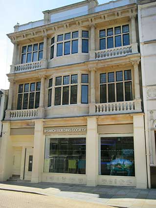
Princes Street (from
King Street to the Station)
Scroll down for a timeline
detailing the piecemeal construction of Princes Street over a number of
years.
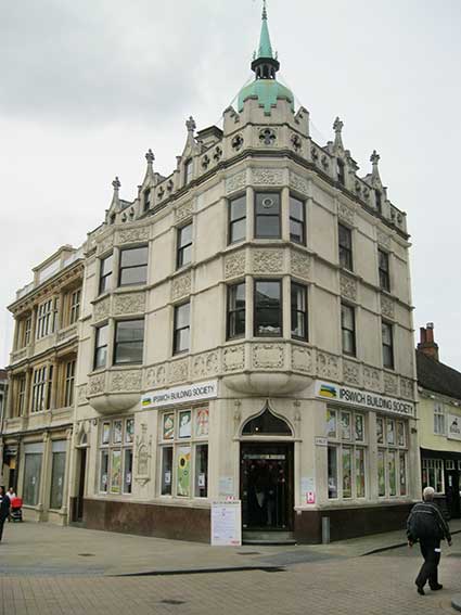
Mutual House, 2 Princes
Street/King
Street
 2015
image
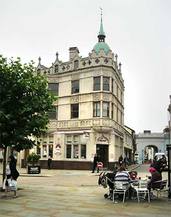
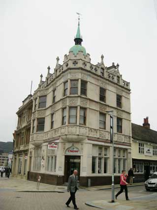
Above: the view from close to the Giles
statue. Thomas W. Cotman, nephew of the famous watercolourist,
John Sell
Cotman, was the architect of the Parr's Bank (later
Chelsea Building
Society and, in 2017, refurbished as a new town branch of Ipswich
Building Society*) at the corner of King Street and Princes Street.
His other stone-faced buildings in Ipswich include The Crown and Anchor, Lloyds banking
house on Cornhill and the heavily
decorated and dated '1905' building at 40-42
Museum Street. Mutual House adjoins The
Swan tavern in King
Street (as shown in the first photograph). "The style is a sort of
c16 French Gothic, similar to the Crown & Anchor, Westgate Street,
faced in stone. Four storeys. Two-storey oriels (one on the corner,
with copper dome and spirelet) and friezes of decorative panels.
Parapet pierced with quatrefoils and broken by gabled dormers with
pinnacles." [Bettley/Pevsner – see Reading list]
*Please note that Ipswich Building Society changed its name to Suffolk Building
Society in 2021.
 2015
images
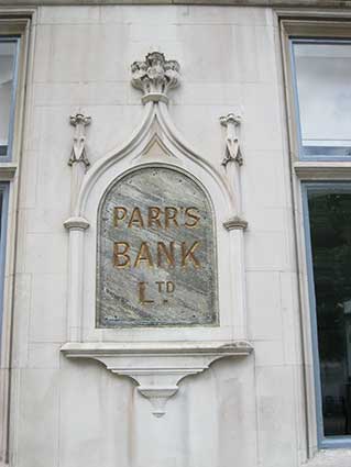
Above: one feature not mentioned is (on the Princes Street facade) the
gold, chiselled lettering within a kind of Gothic cartouche in relief
stonework;
'PARR'S
BANK
LTD.'
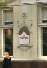
Very grand. The small image above shows that this lettering was
covered for some years by a Chelsea
Building Society sign.
 2018 image
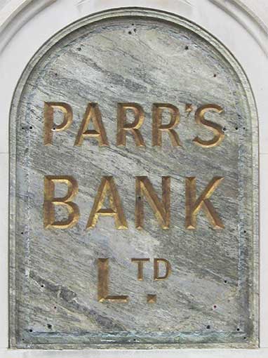
The veining of the blue-grey mineral panel is a perfect setting for the
gold-painted chisel capitals, despite the damage caused by the fixing
of a covering sign (a range of drill-holes and plastic rawlplugs).
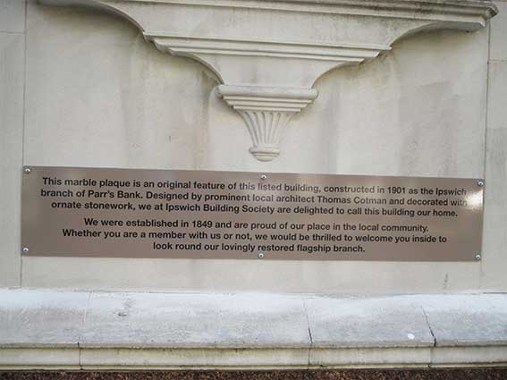
Above left: The Ipswich Building Society's refurbishment of the
building was celebrated with this metal plaque sited just below the
Parr's Bank sign.
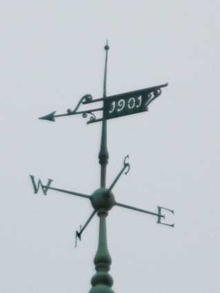
It was only in 2014 that we noticed a pierced date on the stylish
weather vane:
'1901'
in 'art nouveau'-type numerals.
Queen Victoria died on Tuesday, 22 January 1901 at the age of 81 to be
succeeded by her son and heir Edward VII. With
a reign of 63 years, seven months and two days, Victoria was, until
recently,
the longest-reigning British monarch and the longest-reigning queen
regnant in world history. (That is, until Thursday 22 October 2015 when
Victoria's great-great granddaughter, Queen Elizabeth II, became the
longest-lived and longest-reigning monarch of the United Kingdom.) The
new century and a short-lived period which has come to be known as
'Edwardian' beckoned and the volcanic events of the 20th century
followed. Chelsea House (Parr's Bank) was built at this
important
crossroads in history.
 Images
courtesy
Ipswich Building Society
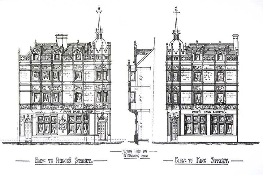
Architect's drawings of
Parr's Bank, showing the Princes and Kings Street
elevations with
the lettered cartouche – which is still to be seen – with some further
lettering above ground floor window level: 'PARR'S BANK LIMITED.'.
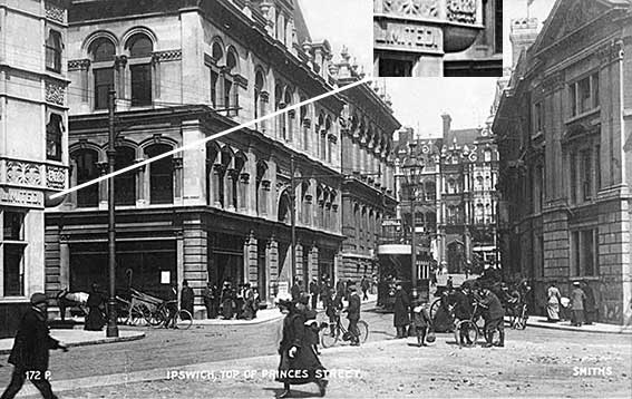
This postcard (perhaps 1910-20) shows at the extreme left some of the
raised lettering on the stone work of Parr's Bank. At the time of
modernisation, this was a plain slab.
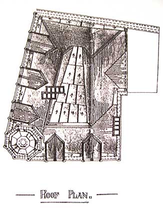
The aerial drawing is unusual showing rainwater flows, accesses,
dormers and the spirelet at lower left.
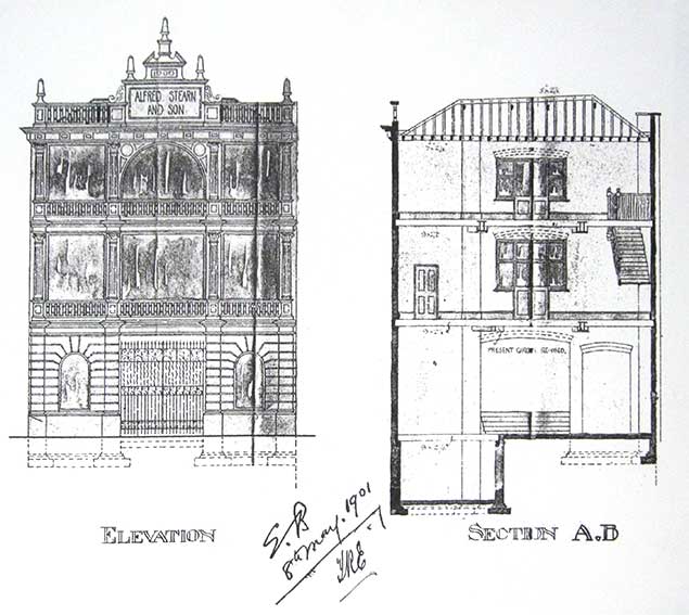
Above: ironmongery business, Alfred Stearn & Son (named on
the upper
panel (with '1900' above), later relettered: 'Commercial Union
Buildings'). Architect's
drawing showing considerable difference to today's aspect (below).
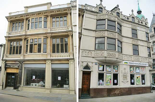 2017
images
(A fire in October 2016 scorched the pilaster to the left of the
Stearn's building; this clearly indicates that the stone-like material
used as cladding, at least on this building, is a fibre-heavy compound.
The new owners have repaired this damage.)
Parr's Bank Ltd (1788-1918).
This private bank was established in Winwick Street, Warrington, in
1788 as Parr & Co by Joseph Parr, sugar boiler, Thomas Lyon, brewer
and sugar boiler, and Walter Kerfoot, attorney; it was also known as
Warrington Bank. The bank was styled Parr, Lyon & Greenall from
1825 to 1851 and Parr, Lyon & Co from 1855 to 1865. Branches were
opened in St Helens (1839) and Runcorn (1853). In 1865 the bank was
reconstructed as a joint stock bank with limited liability, Parr’s
Banking Co Ltd. The partners in the old business were paid £100,000 and
the paid-up capital of the new bank was £100,000. Joseph Parr's son
Thomas Parr was appointed chairman and the bank recruited John Dun,
from Bank of Scotland, as its first general manager. In 1877 a
purpose-built banking house was opened in Winwick Street. The bank
expanded by acquisition of many other banks from 1865 to 1915 including
in 1909 Stuckey’s Banking Co Ltd of Taunton (or the Somersetshire
Bank), which “wielded great power in the west of England” and had the
largest note circulation of any bank in England outside the Bank of
England". In 1892 the bank became known as Parr’s Banking Co &
Alliance Bank Ltd. By 1890 it had 43 branches and sub-branches, rising
to 136 in 1900 and to 329 by 1918. In 1896 the company’s name was
shortened to Parr’s Bank Ltd. In 1918 Parr’s Bank Ltd amalgamated with
London County & Westminster Bank Ltd of London, to form London
County Westminster & Parr’s Bank Ltd. At that date 235 branches and
94 sub-branches were operating.
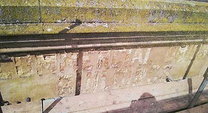
After Alfred Stearn & Son had vacated the next-door building it was
taken over by Commercial Union Assurance and they went to the trouble
of having the words:
'COMMERCIAL UNION
BUILDINGS'
in relief on the upper
stone tablet. During renovation, a covering layer of cement render was
removed here and the traces of the letters were discovered where a
previous builder had hacked them off around the mid to late-1950s,
presumably when the bank expanded
into this building. The photograph below
shows the remnants of the lettering.
 Enhanced
image courtesy
Ipswich Building Society
[UPDATE 12.9.2017: Heritage
Open Days 2017 in Ipswich revealed a restored exterior of Parr's Bank,
now renamed 'Mutual House' by Ipswich Building Society who will use the
building as their town centre branch. The interior is work-in-progress
at this time. At some time, the two adjoining buildings were linked by
an internal arched entry to extend the bank premises, although the
Stearns part is not included on the Grade II Listing. See the Dogs Head Street page for an
illustration of the former IBS branch on the corner of that street and
Upper Brook Street.]
 2017
images
 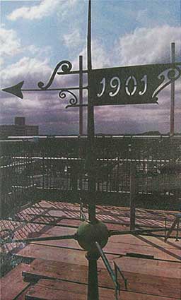 Image courtesy
Ipswich Building Society
Above left: the two
linked buildings to the left and The Swan Inn
to the right. The IBS captioned
photograph, above right reads: 'Gone with the wind!!! The original
building was built in 1901and the final "topping-out" was achieved by
the placement of a dated weather-vane atop the copper dome cupola
structure on the King Street corner of the building. With great care
and
attention to the original mechanism, RG Carter and their specialist,
Hall Conservation, have refurbished and restored to working order the
fantastic Victorian weather-vane.'
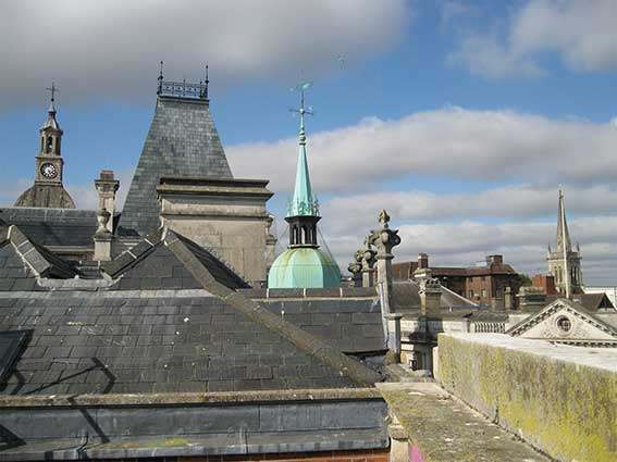 2018 image
Above: the view from the rooftop of post-refurbishment Mutual
House; from the left, amongst various finials: the Italianate
clocktower of the
Town Hall and the kiln-like roof feature of the Corn Exchange, the Mutual House spirelet
bearing the
'1904' weather vane, the spire of the Church
of St Mary-Le-Tower and
below it the palladian top of the Barclays frontage.
For other dated
weather vanes see Tolly
Cobbold Brewery and St Lawrence Church.
See also our Brook Street
and Dogs Head Street pages for
images of a
previous IBS Ipswich branch.
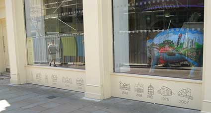
Mini-mural
 2018
images
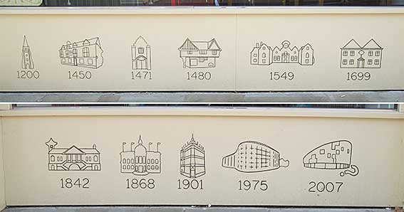
At the base of the Alfred Stearn building, Ipswich Building
Society commissioned a mini-mural, easily missed, showing Ipswich
buildings through the ages.:
1200: St Mary-Le-Tower Church,
1450: The Ancient House,
1471: Pykenham's Gatehouse,
1480: Curson Lodge,
1549: Christchurch Mansion,
1699: The Friends Meeting House,
1842: The Custom House,
1868: The Town Hall,
1901: Mutual House/Parr's Bank,
1975: The Willis Faber & Dumas
offices,
2007: The University of Suffolk Waterfront Building (and '?' sculpture).
A nice addition to the public art of Ipswich.
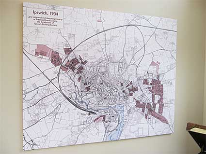
Inside Mutual House
After the official opening of the town centre branch on 23 January
2018, when BBC Radio Suffolk broadcast from the event, Borin Van Loon's
map of the Ipswich & Suffolk Freehold Land Society developments in
Ipswich up to 1934 was on display in the entrance hall of Mutual House,
attracting much comment. See our FLS page for a
larger version.
 2018
images
Also inside the building, some historic bank safes with a
striking branding:
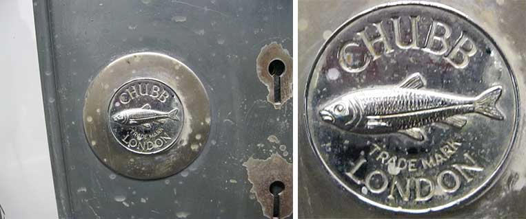
The homophone 'Chubb' uses the the fish, the Chub, as its emblem.
One of the basement strong-room safes has a handsome,
hand-painted
(according to the branch manager) proclamation of the Chubb manufacture:
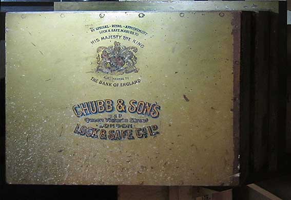 Photograph
courtesy Celia Waters
BY SPECIAL - ROYAL
- APPOINTMENT
LOCK & SAFE MAKERS TO
HIS MAJESTY THE KING
ALSO MAKERS TO
THE BANK OF ENGLAND
CHUBB & SONS
128
Queen Victoria Street
. LONDON .
LOCK & SAFE CO. LD.'
Only, perhaps, the misalignment
of the '128' in the address suggests that it is hand-painted (and not a
transfer).
Britannic House 28 Princes Street
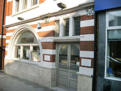 2013
image
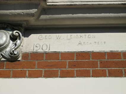
'GEO. W. LEIGHTON
ARCHITECT
1901'
Was this the office of Mr Leighton, or did he sign his
building as a
painter
signs his canvass? Another building signed by the architect is at
number 36 Museum Street ('R.C. Wrinch').
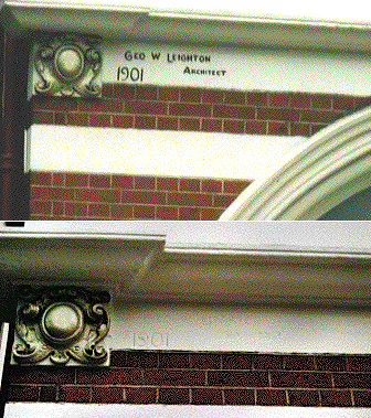 top: 2004 image
 2013
image
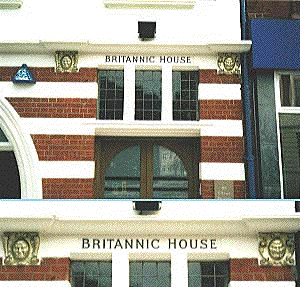
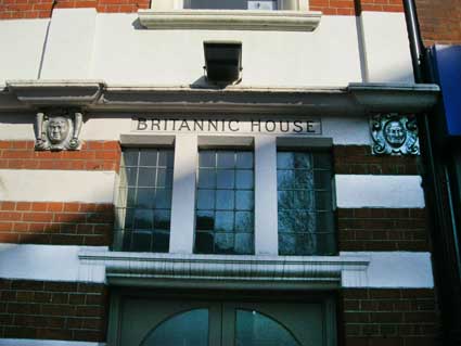
The untidy alleyway beside the building rather
detracts... Unfortunately,
since the above shot was taken in June 2004, the frontage has been
repainted
and the signature made barely visible (lower shot July 2004).
Meanwhile,
the golden crest is resplendant and further along the two
individually-styled
golden grotesque masks either side of 'BRITANNIC HOUSE' (enlarged in
the
inset below).
 2004 image
  2013
image
Britannic House, 28 Princes
Street research
There are, understandably (given the date on the
facade), no earlier trade directory entries until Kelly’s rather exotic entry in
1903: ‘Mutual Life Insurance Co. of New York’. They continued at this
address until at least 1908 (more research required).
Only a few doors down from
Britannic House towards the
junction
with Civic Drive is
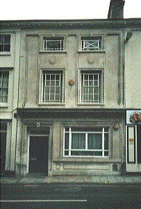
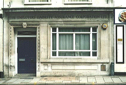
another example of 'lettering over the door'. Beneath the deco-ish
frontage
overhang, it echoes times past: 'THE EMPLOYERS' LIABILITY ASSURANCE
CORPORATION
LTD.' This is number 34 Princes Street.
 -
-
34 Princes Street
research
Stevens Directory, 1881:
’Wells, Wm George, manager for T. Moy, coal merchants’.
Stevens Directory, 1890: ’Moy,
Thomas, Coal and Lime Merchant, and at St Peter’s Wharf and Commercial
Road – W.H. Chittens, Manager’.
Kelly’s Directory, 1903:
‘Haward, Arnold John, solicitor, clerk to the guardians &
assessment committee of Samford union & to the Samford rural and
district council & school attendance committee’. [N.B.: Samford
Rural District was within the administrative county of East Suffolk
between 1894 and 1974. Under the Local Government Act 1972, Samford
Rural District was abolished in 1974, and its area became part of the
district of Babergh.]
We do not know when these offices became The Employers' Liability
Assurance Corporation Ltd. The company ran from 1881-1960 – although
we’ve seen a reference to 1779 as a start date; it eventually became
part of the Aviva group.
Sun Buildings, 35 Princes Street
Up the road opposite the junction with Museum Street
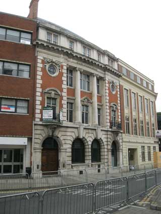
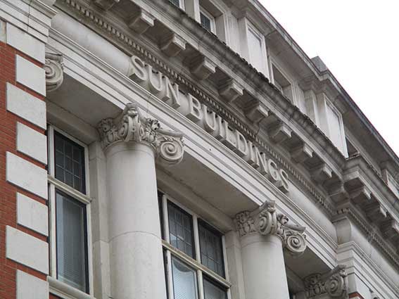
this fine office block, built on a curve:
'SUN BUILDINGS'
stands in relief against a curving cornice,
above
soaring
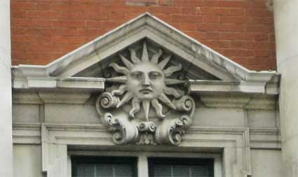
ionic columns. Below, the solemn faced sun motif sitting on scroll
flourishes
is a nice touch repeated in the wrought iron balcony trims. Designed
by E.T. Johns and built in 1913 for the Sun Fire Insurance Company this
building, photographed in June 2013 before a national bicycle race
(hence the barriers and lack of people), was empty with a 'Sale
agreed' sign on it.
 2013 images
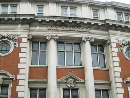
The Sun Alliance Building (adjoining Century
House at right) has a heavily
rusticated
stone first floor to suggest strength. The central section of the first
and second storey is framed by Ionic columns with large windows set in
the brick facade. The cartouche with the sun, the company's emblem, is
set above the central window on the first floor. E.T. Johns' work can
also be seen across the road in the form of the former Frasers
building, examined below.
 2025 image
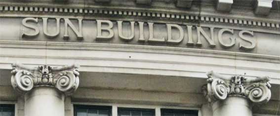
The 2025 photograph looking up at a fairly steep angle
shows the difficult task achieved by the stonemason: serif'd capitals
standout from a horizontal (which is curved in section), but which also
curves to obey shape of the facade.
See our Ancient House
page for a 'Sun'
fire-plate, placed there by the Sun Fire Office, an early
incarnation of the Sun Alliance company (that page gives a potted
history of the insurance company). Also our Sun
Inn page for another sun-themed fire-plate.
39 Princes Street, Century House
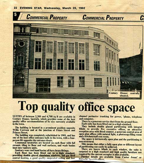
[UPDATE 14.3.2016: "You
might be interested to see the two attached images. The cutting from
the Evening Star, dating from
1992, is pretty self-explanatory. It's an advertorial for the building,
and I clipped it then because I already had the other picture.
 Images
courtesy John Bulow-Osborne
[In the 1992 cutting above: the Sun Buildings at left
and the
Willis building (Listed Grade I) at right background.]
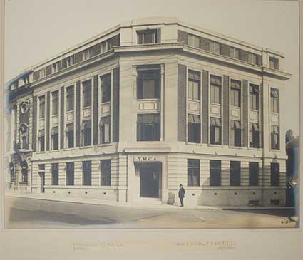
Sadly, I cannot put a date on the other one, but the man with
the
trilby hat, and what appear to be trolley bus overhead lines - why
didn't they use Photoshop? - must give a rough guide. 1930s probably.
Furthermore, in case you struggle to read the text, it says:
'PREMISES FOR THE Y.M.C.A. Johns &
Slater, F. & A.R.I.B.A.
IPSWICH
IPSWICH'
I don't know when Birkin Haward joined them [c. 1946] but this was obviously
before he did, or when he was yet but a junior assistant. You will note
that the main entrance was originally on the corner. I also have a
picture of a small part of the interior, but no lettering visible. John
Bulow-Osborne." Many thanks to John
for details of an often-overlooked building at the corner of Friars
Street and Princes Street.]
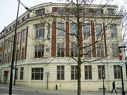 2017
image
The photograph above right shows the building in 2017. The angled,
corner entrance has been blocked and the door to the left enlarged. Sun
Buildings just visible at far left.
For another building used by a Young Christian
Association at
one time, see the Garratt Memorial Hall (Gainsborough House) in Bolton Lane.
Friars Street
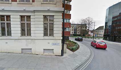

At the far right corner of Century House is an unusual street nameplate featuring the
superfluous full stop after 'ST'; older street signs used the superior
'T' to indicate the contraction. An argument can be indulged in for
adding/omitting a possessive apostrophe – on one side of the 'S' or the
other, given the plural of 'Friars' –as seen on a few street signs in
Ipswich: e.g. St Edmund's Road, Arthur's Terrace and St Margaret's
Green. This corner marks the part of Friars Street which was reshaped
during the building of the Willis building in the 1970s which also saw
the disappearance of Friars Road (roughly becoming the dual carriageway
Franciscan Way) and the stump of Thursbys Lane (opposite the southern
end of Museum Street – itself part of the original Thursbys Lane).
Further information and maps can be seen on our Lost trade signs page (under 'Before and
after Willis') and Museum Street page.
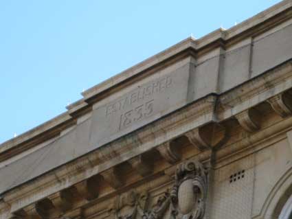
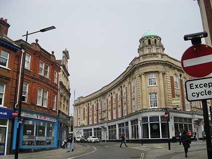
Former Frasers building, 23 Museum
Street
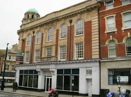
The former Frasers furniture shop on
the corner of Museum and Princes Street, later
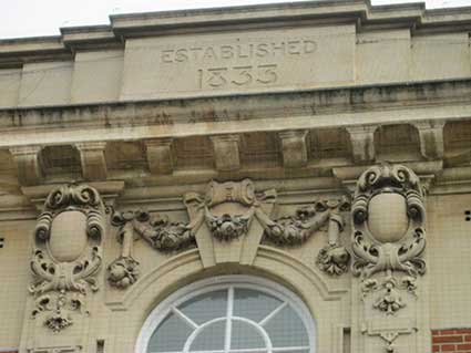
Maples, is now offices. Right at the top above the stone swags and
decoration
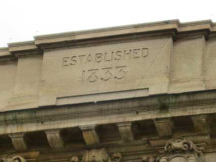
is
the date at which the company was set up, rather than the date of
building:
'ESTABLISHED
1833'
with stylish numerals such as the '8' with its
flattened top. This feature is repeated round the
corner
in Princes Street (see below).
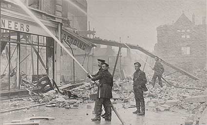 Photo
courtesy The Ipswich Society
R.D. and J.B. Fraser's furniture emporium burned to
the ground in a famous and well-photographed fire on the sixth of
April, 1912. The horse-drawn fire engines of the time were outdone by
the fire which, seeming to have been extinguished, flared up again
later that night. Apparently rolls of linoleum burned and exploded,
spreading the fire to other shops in the area. The building we see
today is a replacement by E.T. Johns from 1913-14(?) of the original,
short-lived, Frasers building by Eade & Johns in 1890.
Incidentally, horses weren't abandoned by the
local fire service until 1920.
For images of the lost Frasers store and its hanging signs, see our Albert Clarke, Art Smith page.
We recall this building as as Maples
furniture store
in the late 1970s with mountainous sofas and armchairs and
more-than-life-size china greyhounds.
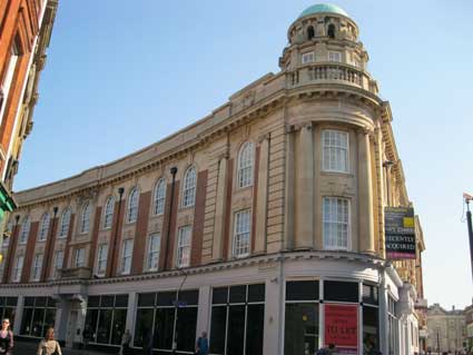
 2013 images
Below: the facade on
Princes Street.
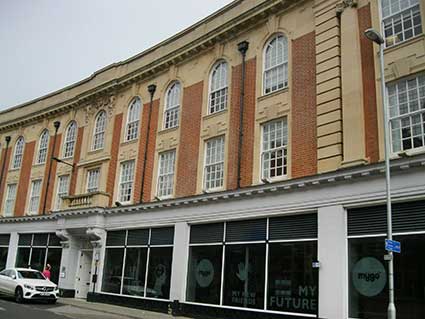
The Frasers building turns a tight corner onto a longer facade
stretching up Museum Street:
 2017 images
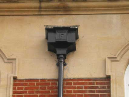
It was only in 2017 that it was pointed out to us that the rain
hoppers here bear the initial 'F', so we can add them to
our Rain hoppers page. Below also, the
decorative swags and flourishes high above the central doorway on
Museum Street, separated from the company's date of establishment by a
modillion cornice.
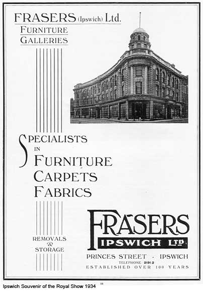
The advertisement below shows the company promotion in 1934.
Boasting: 'Established over 100 years', this confirms the 1833 date on
the cornice.
The views from Willis
(1) (2)
(2)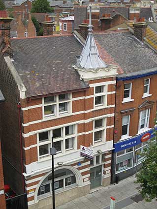
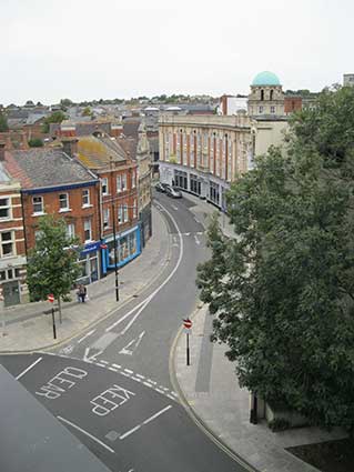
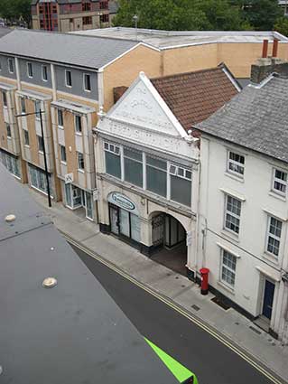
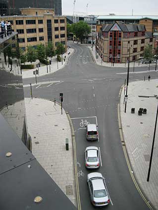
On Heritage Open Day 2015 the views from the Willis building
roof garden show (1). the junctions with Friars Street, Princes Street
and Museum Street with the old Frasers
building at right. (2). The George W. Leighton building at No.28. (3). Fred Smith & Co. building and (4)
the
remodelled junction of Princes Street with Civic Drive (right) and
Franciscan Way (left); the junction with Friars
Bridge Road is on the right in the distance.
(3) (4)
(4) 2015 images
See also our Coytes Gardens page for a note about the
way in which Princes Street was cut brutally through existing gardens
and buildings to link Cornhill and Friars Bridge and then, in 1860,
Railway Station Road (now all called 'Princes Street'). Railway Station Road included the
Princes Street bridge: see below.
Princes Street timeline
1845-
proposal by
Eastern Union Railway company (EUR) to build a
bridge over the Orwell. We believe that works to cut Princes Street
from Queen Street to Friars Bridge (the north end) were started at this
date, too.
1846- EUR opened
the original
railway station in Croft Street. The tunnel, engineered by Peter
Bruff, through Stoke Hill (’Stoke Bone Beds’, so-called because
of the important fossils found during construction) was dug in the same
year to
facilitate the extension of the railway to Bury St Edmunds.
1849- some sources
quote this as the date on which the original timber and
iron bridge over the river opened, but this doesn't fit with other
landmarks on this timeline.
1856- The New
Cattle Market was
relocated to a site either side of Friars
Bridge Road (now a car park
between the rear of the AXA block and Portman Road) from 'The Old Cattle Market' at the top of
Silent Street (now mainly known as a country bus station); The surface
of the marsh was raised about two feet to provide a firm, dry site for
the cattle pens. It was
served by the new road from the railway and the Old Cattle Yard on the
railway spur serving the dockland (see our page on Water
in Ipswich for a photograph and more
detail).
1860- the railway
station,
resited from Croft Street to today’s Burrell Road/Ranelagh Road
location, opened. The road across the river to Friars Bridge was
for a short time known as ‘Railway Station Road’ – and appears as
such on some maps.
Bob Malster in Ipswich: an A to Z of
local history (see Reading list)
states: "Even this much [the northern part of Princes Street] was
unfinished when the railway station opened in 1860 and a timber bridge
was thrown across the river to carry the new Railway Station Road." As
well as the original timber and
iron bridge over the river, the new road (later Princes
Street) which ran across the marshes to Friars
Bridge Road, also Commercial Road (now Grafton Way) linking Railway
Station Road with Stoke Bridge were opened.
The town end of Princes Street (named after Prince Albert, died 1861)
was ‘a street bored through a mass of houses, gardens, streets and
lanes diagonally, leaving corners and angles of old buildings, dead
walls with the marks upon them of gable-ends dislodged, and bits of
lanes running off at curious angles.’ [Hunt, W.: Descriptive handbook of Ipswich,
1864 – quoted in Malster, R.: A
history of Ipswich, see Reading list]
This stretch of road (today, Cornhill to Willis) was much-delayed by
negotiations with numerous property owners; the delay extended by a
decision to build it wider than originally planned, leading to further
renegotiations. It was clearly unfinished by 1864.
1866- The
R&W Paul maltings
fronting Princes Street and just over the river from the station were
refashioned by J.R. Cattermole (date according to the Grade II Listing
text and the foundation stone shown on the Burtons
page), having being built in c.1820. Unfortunately, this doesn't tally
with the building of Railway Station Road in 1860; the assumption that
Cattermole was employed to cut back the eastern face of the maltings to
enable the building of the new road, may be erroneous. Is it possible
that the new road swerved round the projecting building for six years,
or was the reshaping done for a different reason?
c.1870- The Railway
Hotel was built on the south side of the bridge over the river, with a
frontage on Burrell Road.
1878- Princes Street was officially made a public
highway. The
whole stretch from the station to Queen Street junction became known as
Princes Street. Today we consider that it reaches the few extra yards
up to the Cornhill. It is the longest
single street in Ipswich.
1883- the island
platform
(Platforms 3 & 4) of the railway station was built to facilitate
more trains, accessed by a footbridge from Platform 2 (see the casting
plate below).
1913- Sun Buildings
at 35
Princes Street (shown above) opened.
1927- The original
road bridge
over the Orwell (described in July 1860 by The Ipswich Journal as 'rugged and
aboriginal in appearance') was replaced by that seen today: built in
concrete steel and stone.
Princes Street bridge
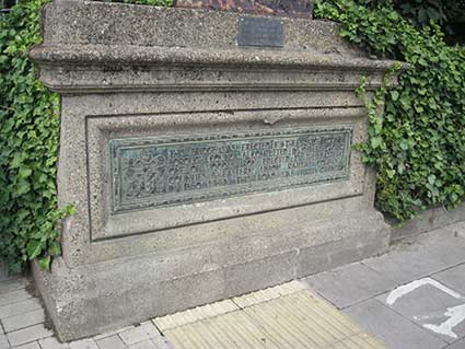
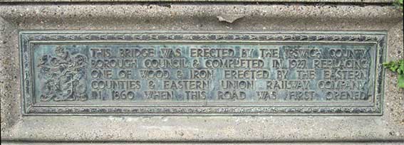
Down at the railway end of Princes Street, past the R&W Paul maltings (formerly a night club)
we find the plaque on Princes Street bridge. It reads as follows:
'THIS BRIDGE WAS ERECTED BY THE
IPSWICH COUNTY
BOROUGH COUNCIL & COMPLETED IN 1927 REPLACING
ONE OF WOOD & IRON ERECTED BY THE EASTERN
COUNTIES & EASTERN UNION RAILWAY COMPANY
IN 1860 WHEN THE ROAD WAS FIRST OPENED.'
Another trace of the pre-1974
Local Governemnt Reorganisation 'Ipswich County Borough Council' can be
seen on street nameplates on Civic Drive.
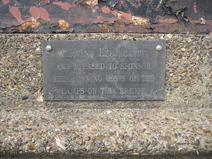
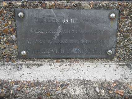 2018
images
Directly above the large plaque
on the Ranelagh Road side is a smaller plate reading:
'EASTERN ELECTRICITY
ARE PLEASED TO SPONSOR
THE RUNNING COSTS OF THE
LAMPS ON THIS BRIDGE'
Elsewhere is another small plaque
reading:
'THE LAMPS ON THIS BRIDGE
WERE PRESENTED TO THE TOWN
IN 1985 TO MARK THE CENTENARY
OF THE IPSWICH EVENING STAR'
Station
Hotel

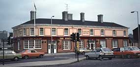
Above left: the view from the reshaped station forecourt
in
2018; Princes Street Bridge over the river is visible at left. Above
right: the building in 1982, photograph courtesy The Ipswich Society
(see Links).
 2018
images
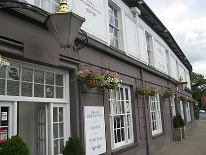
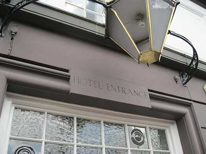
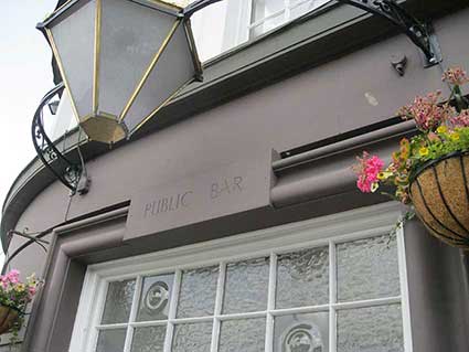
Noticed during our research into public clocks, the words
'HOTEL ENTRANCE' (west) and 'PUBLIC BAR' (east) are incised ito
the lintels above the entrances on Burrell Road. Another, unlettered,
entrance to the bar opens onto Princes Street, but that look as as if
it might have originally been a fire entrance. This building opened as
a bar/hotel directly opposite the railway station (before or) in 1860.
It is suggested that the design might have been by the great railway
engineer, Peter Bruff, who had an influence n the station buildings
opposite.
Ipswich
Station
[UPDATE
6.4.2018: this is a good place to include a piece of cast iron
lettering in the railway station. Incidentally, a 1969 photograph of
the station frontage appears at the top of our Ipswich station and
Westerfield-Felixstowe
Branch Line page. Many Ipswich residents will remember crossing the
main line to the island platform to catch Norwich, Cambridge and other
trains. The upper sections of the original cast iron bridge were open
to the elements many years ago (now glazed) and it could be a very
drafty experience. Des Pawson has drawn our attention to a founder's
plate on the bridge, so many thanks to him.]
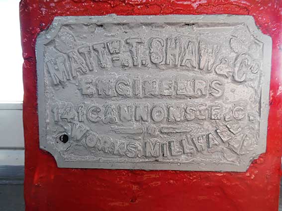 2018 image
courtesy Des Pawson
'MATTW.
T. SHAW & CO.
ENGINEERS
141 CANNON ST. E.C.
– O –
WORKS MILLWALL'
The cartouche bearing the iron founder's name is now
choked with layers of paint, but still readable. Grace's Guide (see
Links)tells us:-
Matthew T. Shaw and Co. of West Ferry
Road, Millwall, London E.C.
1850 Company founded by Matthew Turner Shaw;
1856 Matthew T. Shaw, in business as iron and steel merchants in George
St, Mansion House, London;
1859 Matthew T. Shaw of 64
Cannon Street, London EC.;
1868 Matthew T. Shaw of
142 Cannon Street, London Bridge, London EC.;
1879 Messrs. Matthew T. Shaw & Co., of Cannon Street, supplied
wrought iron girders and cast iron columns for a multi-storey building;
1886 Death of Matthew T. Shaw, senior partner in a business at 139-141
Cannon St [this is the address shown on the casting plate above; the
Princes Street timeline, also above, gives the date of the building of
the island platorm as 1883];
1886 Matthew T. Shaw of London
Constructional Iron and Bridge Works, Millwall;
1895 Private limited company;
1914 Matthew T. Shaw, Constructional
Engineers, Bridge Builders. Specialities:
high-class constructional steel and ironwork, bridges, roofing,
girders, sheds, tanks, forgings. Employees 25;
1937 Matthew T. Shaw, Structural
engineers;
1961 Matthew T. Shaw, Structural
engineers and structural steel work fabricators.
Ipswich railway station was re-sited from the original EUR station site in Croft Street to its present
location in 1860 and the main building was thought to be principally
the work of Peter Bruff (the engineer of Stoke railway tunnel); who had
certainly started the structure. The actual design was in the
Italianate style and submitted by architect Sancton Wood (1816-1886) as
part of a competition. When the new station was completed, a new road
(Railway Station Road, later an extension of Princes Street) linking
the station to the town was also opened.
By the 1860s the railways in East Anglia were in financial trouble and
most were leased to the Eastern Counties Railway (ECR). Although they
wished to amalgamate formally, they could not obtain government
agreement for this until 1862, when the Great Eastern Railway (GER) was
formed by the amalgamation. The island platform at Ipswich was added by
the GER in 1883. Although access to such a platform could be achieved
by boardwalks across the lines at the end of the platform slopes, it is
most probable that the footbridge was built in 1883.
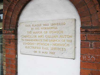 2018 image
On platform 2 is a rather grand plaque:
'THIS PLAQUE WAS
UNVEILED
BY THE WORSHIPFUL
THE MAYOR OF IPSWICH
COUNCILLOR MRS GILLIAN AUTON
TO COMMEMORATE THE LAUNCH OF THE
LONDON–IPSWICH–NORWICH
ELECTRIFIED SERVICES
ON 11 MAY 1987'
See our page on the Felixstowe branch line for 1956
photographs of Ipswich station and track.
See our page on Public
clocks in Ipswich for a 2018 view of the station car park and its
clock.
See also our Lettered castings
index page.
Home
Please email any comments
and contributions by clicking here.
Search Ipswich
Historic Lettering
©2004 Copyright
throughout the Ipswich
Historic Lettering site: Borin Van Loon
No reproduction of text or images without express written permission
 2015
image
 2015
images

 2018 image

 Images
courtesy
Ipswich Building Society


 2017
images
 Enhanced
image courtesy
Ipswich Building Society
 2017
images
  Image courtesy
Ipswich Building Society
 2018 image
 2018
images

 2018
images
 Photograph
courtesy Celia Waters
 2013
image
  top: 2004 image
 2013
image
 2004 image
 2013
image
 -
-

 2013 images

 2025 image


 2013 images


 2017 images


 2015 images


 2018
images


