Paul's and Burton's, The Bull
Inn
R&W Paul silo, Common Quay
Moving up the quayside past the excellent remodelling
of the
Paul's Home
Warehouse (formerly occupied by Contship, now
solicitors' offices), we used to see
looming above the columned 1845 Custom House:
'R.
&
W. PAUL Ltd' on the 1960s Wunderhaufen malting plant. Now demolished as
part of the Waterfront
Regeneration
Scheme,
this lettering appears on the silo on St
Peter's Wharf, too (see
below, next to the old Burtons building).
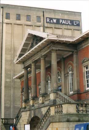 2003 image
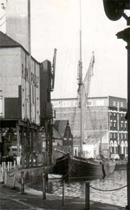 1970s?
Above right: the
close-up from a 1970s(?) view of the dock from our The changing dock page shows the view at
the time of the warehouse which became Contship offices and later
Ashton Graham. The jettied part over the quay which enabled unloading
from ships is encased in corrugated iron and also bears the name (just
readable):
'R&W PAUL LTD.'
See our Paul's malting page for the
story of the company and its importance to Ipswich.
The Bull Inn, Key Street ans
Slade Street
A survivor of many attempts at demolition over the
years (not least by
the
German air force) which stands opposite and behind these buildings on
Key
Street (originally Quay Street) is The Bull Inn. The upper cream band
and
painted blank central window once carried the brewery name 'COBBOLD' (also on the strip over the coach entrance to the
right) and pub's
name 'THE BULL'
(see black and white view from 1963 below).
This 19th century frontage
features
a coaching entrance which gives a glimpse onto 16th century buildings
of
old Ipswich. The Bull stood only a few metres from other dock
hostelries:
The Gun, The Maltster's Arms and The Ram. Its importance in the town is
shown by a rating assessment in 1681 of £40 a year (£5 a
year
more than that of the White Horse). A great stableyard replete with
blacksmith
and wheelwright lay behind it. A First World War Zeppelin delivered a
bomb
which destroyed the roof and killed a man in a house next door. After
its
rebuild, the centre of commercial activity in the town moved northwards
to Carr, Tavern and Westgate Streets and it finally closed in
September,
1961.
The 'inn', as distinct from hundreds of ale-houses,
parlour pubs (for the lower orders), taverns
(more substantial, tended to specialise in wines and could provide a
good meal) which dotted the town, was second only in size to the
churches. The inns catered for wealthier local people and travellers.
The bigger ones could cater for 200 to 300 people and, as with the Bull
Inn, provided stabling for visitors' horses. They hosted such
events as feasts, concerts, trade association meetings and
electioneering. During the 15th and early 16th centuries Ipswich was
the fifth wealthiest town in England with many important visitors (via
coach and horse or ship into the town's docks) and pilgrims to the
Shrine Of Our Lady Of Grace in Lady Lane
off Black Horse Lane, so several inns must have provided overnight
accomodation.
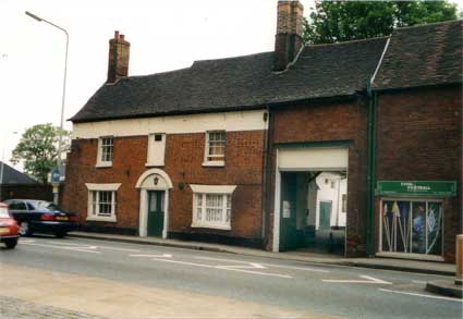 2003 image
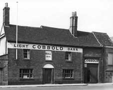 The
Bull Inn (1960s?)
The photograph below takes us to more recent memory: the 1970s.
From Duke Street roundabout westwards the zig-zagging Fore Street,
Salthouse Street, Key Street and College Street was then the only
street through the docks (long before the demolitions which led to the
building of the eastern gyratory's Star Lane) and was two-way as shown
in the contemporary photograph below. The surviving buildings in the
image below are the Bull Inn and the coaching entrance beyond it.
At the site of Brown's timber yard, the present day Slade Street cuts
through and the rather grand offices at the corner beyond are still
standing.
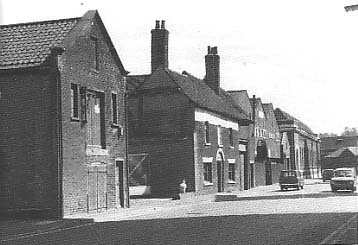 1970s
1970s
Above: the Bull Inn (centre) in the 1970s; beyond that
are: Brown's
timber yard (see more about William Brown),
Paul's offices and, across Salthouse Street, Isaac Lord's.
Below: the Bull Inn during refurbishment as accomodation, images
from the Ipswich Society Flickr collection (see Links)
with the roof timbers shown.
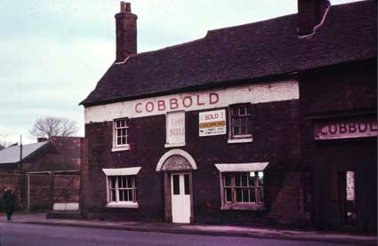
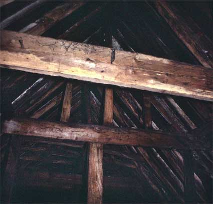 Photos courtesy The Ipswich Society
Below – from JohnBulow-Osborne: 'From an old Cobbold
publication, in 1923, The Bull pub in Key Street, by the waterfront'.
John also sent an image of The Saracen's Head on St
Margarets Green from the same source.
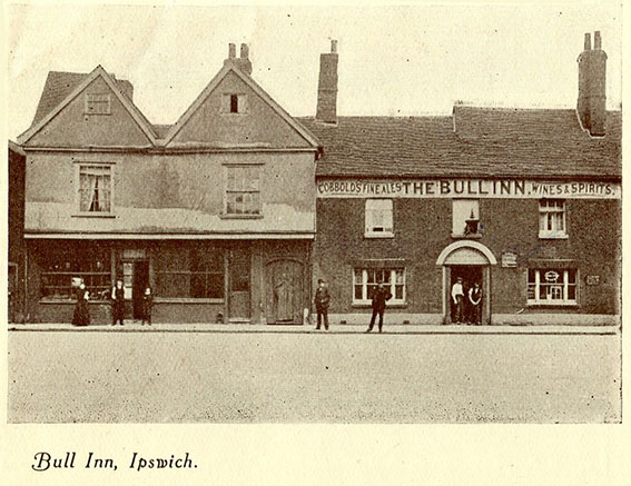 Image
courtesy John Bulow-Osborne
The 1923 photograph of The Bull reveals the timber-framed
building to which it was joined with a shop below and entrance gate and
passage to the back yard. The lettering on the upper strip of white
below the eaves is revealed:
'COBBOLDS
FINE ALES
THE BULL
INN
WINES & SPIRITS'
The words on either side are on
rolling curves with painted curving lines; the pub name has a smaller
definite article and the characters appear to have a drop shadow. The
blind window in centre features a projecting (gas?) lamp.
Below: a photograph from the Ipswich Maritime Trust
(see Links) collection showing a pie-man
making a delivery in the late 19th century. This close-up photograph of
the entrance shows the lettering on the lamp: 'Bull Inn' followed,
presumably, by the landlord's name (unreadable here). Then there are
the capitals 'THE BULL INN.' curving round the painting of a bull in a
landscape – the silhouette of the horned animal is still visible at the
centre. A licencing statement, white lettering on black, is to the
right. The poster to the right of the door shows a paddle
steamer, presumably advertising the service from the Steamboat Tavern
on New Cut West.
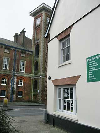
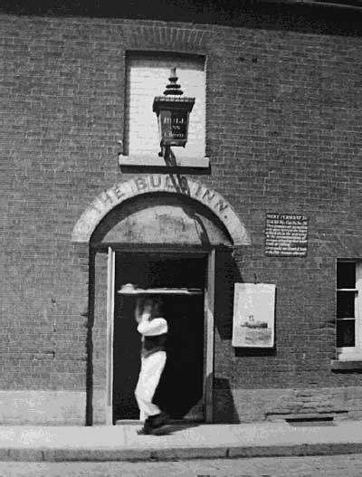 Late 19th century courtesy Ipswich Maritime Trust
IMT plaque
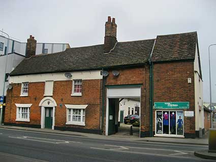 2018
images
'MARITIME IPSWICH
1982
FORMER BULL INN
TIMBER-FRAMED TUDOR HOUSE
WITH EARLY 19c FRONT
IPSWICH SOCIETY TRAIL CAST BY
CRANE LTD'
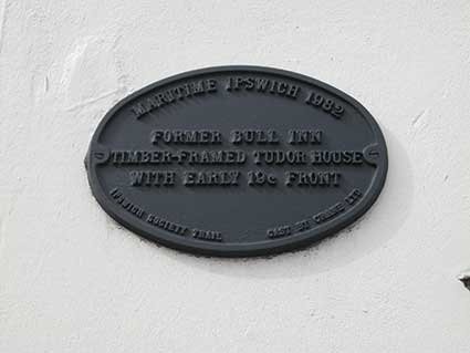 2017
images
See our plaques page
for the full set of ten Ipswich Society Maritime Ipswich
1982 plaques.
Mystery
plaque in Slade Street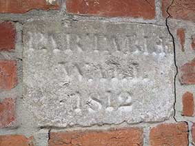
The Bull Inn perimeter wall runs up the tiny Slade Street, named
after the naval architect, Sir Thomas Slade (memorial outside St Clement Church). Slade Street doesn't
appear on the 1902 map of Ipswich. The east side of The Bull Inn was a
Malthouse with a narrow lane. Presumably it was this lane which was
widened after certain demolitions in the area to form Slade Street, as
part of the Easter gyratory system in the 1980s; it now links Salthouse
Street/Key Street with the extended Star Lane. A lettered stone tablet (thumbnail at
right) can be found in Slade Street, just past the Maritime Ipswich
1982 metal plaque. It's easily overlooked – we missed it. It appears to
read: 'PARTABLE WALL 1812' (or similar). If anyone can shed a light on
this feature, please contact us (link at the foot of the page).
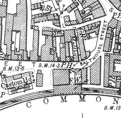
Below: the 1902 map detail showing The
Bull Inn ('P.H') as Salthouse Street becomes Key Street. A blackmith's
premises ('Sm.') can be seen to the rear of the inn – fitting for an
inn which apparently had so many stables. The cart entrance to the
courtyard can be seen. On the east is a long, narrow malthouse
('Maltho.'), then the alleyway which became Slade Street.
 1902 map
detail
Burton's factory, St
Peter's
Wharf
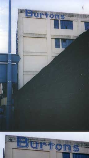
The photograph below left: a view from
College Street,
standing
opposite
to the 'water gate' of Wolsey's failed seat of learning shows the
lettering before the Waterfront Regeneration started (see it disappear
below). A
stylish blue
drop-shadow letterform adorns this stark 'BURTONS' block, though the
capital
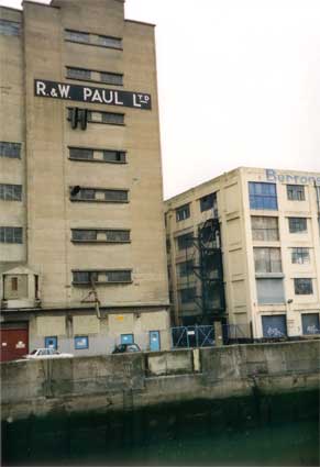
'B' shows that the signwriter ran out of building. Similar lettering
(similarly
too close to the roof-edge) faces the upper finger of the Wet Dock to
the
right of another of Paul's mill (below right, photograph taken from
Stoke Bridge).
See our page on the Trinity House
buoy for more images of the Paul and Burtons buildings and
brilliant scale models.
 2003 images
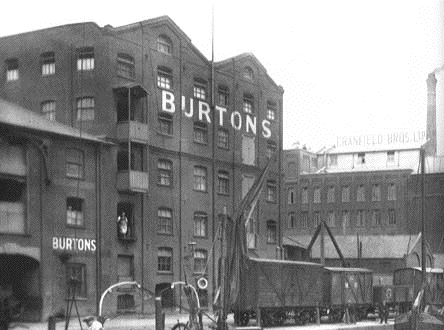
A period view (below) tells a different story. Just
visible in the
background
is the neighbouring Cranfield Brothers Ltd. sign (Cranfields Flour Mill
has only recently ceased operation, pending the Waterfront Regeneration
project). The Burtons premises on St Peter's Wharf has large and small
versions
of the 'BURTONS' lettering. The tops of dockside sailing barges are in
the
foreground with the horse-drawn tramway trucks which until 1880 took
coal
all
the way from the sidings on the other side of the approach to Stoke
Bridge
on a long circuit round the Wet Dock, down Cliff Quay to the power
station
on the promontary. Steam engines and latterly tram engines later worked
these lines, for unloading vessels to load straight into rail waggons.
[See here for a short history of
tramways in Ipswich.]
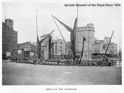
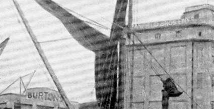
Above: a 1930s view of St Peter's Wharf showing, centre, the
replacement Burtons building we see today, but with a curved projection
in the middle to accomodate the company name: 'BURTONS'; to the right
the huge concrete silo of 'CRANFIELD BROS LTD', which is lettered at
the top, just about visible on the close-up.
There has been a commonly-held belief that the Burtons
factory
on St Peter's Wharf/College Street produced Wagon Wheels and Jammie
Dodger biscuits – indeed we've included it on this website in the past.
However, it becomes clear from further research that there are two
similarly-named companies, both dealing in tooth-cavity inducing
products, but (as far as we can tell) completely separate.
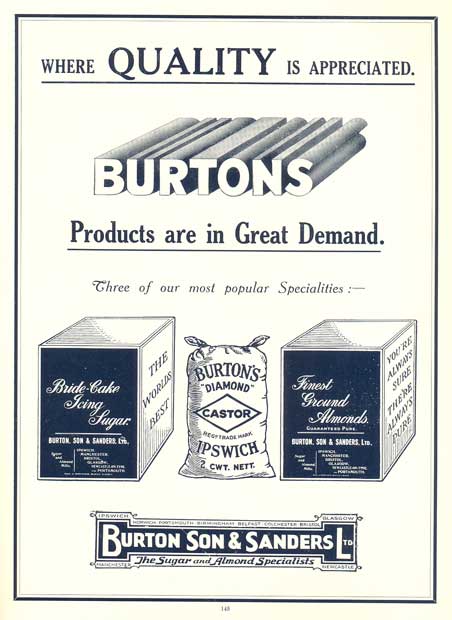 'The
Sugar and Almond Specialists' advertisement
Disambiguation
Burton Son & Sanders
The company started by Charles Burton Senior, retail grocer, in 1824 as
a shop on Tavern Street, near Cornhill, Ipswich. From a
small beginning it steadily grew until it
became one of the largest of its kind in England. The
wholesale business moved to College Street in 1851, making use of the
St Peter’s Wharf on the Wet Dock for imports of goods. Around
1880 Mr
Bunnell H. Burton and Mr (now Sir) William P Burton joined the firm. Two
local wholesalers, H W Caffe Ltd and
Squirrel and Cleveland Ltd, were subsidiary companies. Products
were mainly sold to the bakery and confectionery trade (butter, lard,
jams, peels, spices, sugars, gelatine, isinglass, arrowroot and
imported ground almonds). Cube, icing and castor sugars became major
products, then marzipan from the ground almonds, then fondant,
macaroon paste and most recently cake decorations. The
company merged with Evat Sanders & Son of Colchester in 1897,
becoming Burton, Son and Sanders Ltd. While London offices were
established, branches were opened in Manchester, Bristol, Glasgow,
Birmingham and Portsmouth.
“On the 25th July 1923 a fire started in the main factory [on St
Peter’s Wharf, Ipswich] and continued through the night, completely
destroying the Sugar Mill, Almond processing plant and general
manufacturing section. Immediate warehouse accommodation was obtained
at Flint Wharf on the dock side [see Wet
Dock map] and supplies were drawn from branches, with the result
that within a very short space of time we were able to deliver all
goods promptly from the new Ipswich warehouse or the nearest branch. It
was indeed most fortunate that we were able to surmount this calamity
without serious dislocation of business as it was three years before
the factory was rebuilt and the most modern machinery installed….
… An abnormal tide, coupled with a wind of gale force, was responsible
for the flooding of the College Street
premises at 1 a.m. on Sunday,
1st February 1953, to a depth of 42 inches. This was the most severe in
Ipswich during living memory. The basement of the factory and salesroom
were flooded and were without heat, power and telephones. Lighting was
not available in the office block until the following Wednesday.” (Taken from A
history of Burton Son & Sanders.)
Burton’s Biscuit
Company (fomerly
Burton's Gold Medal Biscuits)
The company was started by George Burton who was born in 1829 in Leek,
Staffordshire and began production of biscuits in Blackpool in the
1880s. Current products of the company include Jammie Dodgers, Wagon
Wheels and Cadbury’s chocolate fingers produced at three main factories
at Llantarnam in south-east Wales, Edinburgh and Blackpool, a chocolate
refinery in Moreton, Merseyside and a distribution depot in
Liverpool; their head office is in St Albans, Hertfordshire.
The illustrations of the Burton's factory shows a single building (or
chain of buildings) lying between a College Street frontage and St
Peter's Wharf. After the disastrous fire of 1923 and the rebuild, by
1926, we think that there were two separate buildings back-to-back: one
fronting College Street, one fronting St Peter's Wharf. The College
Street building is now 'Cardinal Lofts'.
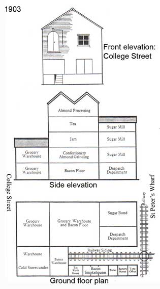 1903 drawings from a selected history of Burton's
What happened next
In 2006 the Burton Son & Sanders factory disappeared and became
'Cardinal Lofts' (the orange building shown below), overlooking their
own
offices in College Street and the Wolsey Gate. It
had its
own railway link from the dockside tramway: "a direct railway line into
the building, the goods being packed nightly." Sir Bunnell H. Burton's
name appears on a tablet behind Anglesea Heights next to the 'Pathology' doorway. In 1895, he also gave
the recently opened Christchurch Park
its drinking fountain on Ancient Avenue, close to today's children's
play area. He was
also a subscriber to the building of the oldest purpose-built library
branch
in the county at Rosehill (see Rosehill
case study).
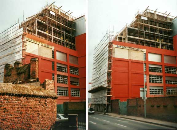 2006
images
[UPDATE March, 2006: During the Waterfront
Regeneration project, the
last vestiges of the 'Burtons' sign on College Street opposite St
Peters Church, as men in yellow jackets erect ever-higher steelwork
above it. Left: 'Burtons' partially obstructed by the lamp post, right:
taken from St Peter's Churchyard, the back of the Wolsey Gate in
the foreground, just as the sun came out. This orange-red building has
been renamed 'Cardinal Lofts'.]
[UPDATE
5.10.2014: "I have read with great interest your articles on the
Ipswich docks. Thank you very much for them. Can you please tell me
whether this building still exists in any form and where it is/was on
the water front... [We replied that
the Burtons redbrick building shown in the black-and-white photograph
above was replaced by the cream-coloured block
which, in a damaged state, still stands today.] Thank you for
your most helpful reply, which has solved a mystery for me. At the risk
of wearying you with family history, I am a descendant of the Burtons
of that business. I was born in Ipswich in 1947 and lived on Belstead
Road. I remember (or think I do) coming down that road and seeing the
dark buildings along the wet dock, including one which looked like that
in your photo. I left Ipswich in 1953. Recently, I have taken to
visiting Ipswich and haven’t been able to relate what can be seen on
the ground to my fading memories, hence my appreciation of your
explanation. Best regards, George (actually my second Christian name;
my first is Bunnell, the same as my great grand-father; I think the
'Bunnell' stems from a marriage between a Burton and a Bunnell in the
nineteenth century) Burton,
Shaftesbury." Thanks to George
Burton – a link to one of the big names in Ipswich industrial history –
for getting in touch.]
Don't forget, much more on the Paul
and Burton's buildings on St Peter's Wharf on our Trinity House
buoy page.
For more images of these buildings and of the
northern quays during the 2005/6 Waterfront demolition and clearances
see our Waterfront regeneration
page.
For a 2007 aerial view of the Stoke Bridge area
featuring these buildings, click here.
R&W Paul maltings, Princes
Street
The twentieth century concrete blocks of industrial maltings and mills
(particularly
R. & W. Paul's) round the Wet Dock [see paragraph above] largely
replaced
the somewhat less severe
brick-built structures of the nineteenth century. A little further up
the
canalised Gipping from Stoke Bridge, we find the red brick maltings on
Princes
Street, across the river from the
railway station. Between 1893 and 1912, R. & W. Paul built a total
of five maltings in the town, the largest of these at the Wet Dock,
making the raw materials (wheat and barley) and end product (malt for
the brewing industry) that much easier to move by boat; coincidentally
one of the Paul brothers had interests in the United Shipping Company.
This building is earlier; built in about 1820 and
refashioned in 1866, it is Listed Grade II. Converted into a
nightclub (called at various times Hollywoods, Kartouche and Zest), the
refurbishment involved the
painting
out of large, stylish capitals reading:
'R. & W. PAUL
LD.'
(there
clearly wasn't space for a 't') plus
its
underline using a terra cotta colour on the upper part of the
attractive
end wall. Oddly, because the characters have been closely followed by
the
camouflager, the name is still readable (see the enhanced close-up
below). Closed down due to a stabbing
in 2006, the building remained empty for a long time, but reopened as a
music venue.
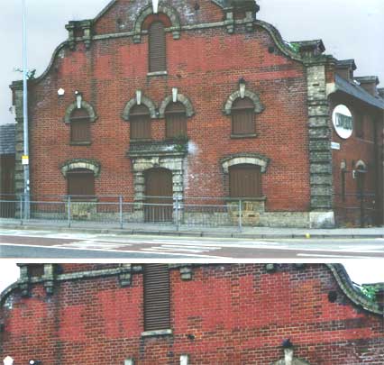 2001 image
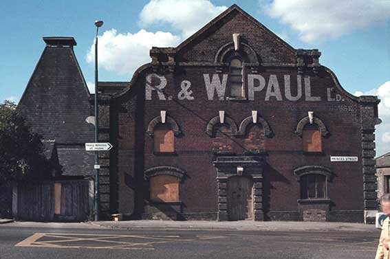 Photograph
courtesy The Ipswich Society
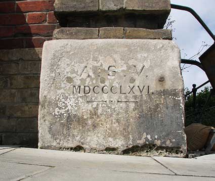
This fine photograph of the building boarded up in the 1980s from The Ipswich Society's Image
Archive (see Links) shows at bottom right the
white foundation stone at the foot of a brick pillaster:
'A.S.V.
MDCCCLXVI.'
The initials may be of the person
who unveiled the foundation stone; the date in Roman numerals is '1866'.
 Photograph
courtesy John Norman
John Norman writes: 'The image of the east elevation is not the
original east end of the building. The maltings were originally
constructed in circa 1820, with the new east elevation added later (see
date on foundation stone). The maltings, as I understand things, were
never owned by Paul’s but rented off the Ipswich Corporation, (the
original landowner of Portman’s marshes) and then only used
occasionally. I think these were Paul’s No. 7 maltings, only used when
they were very busy. They were labour intensive and inefficient but a
useful reserve to increase capacity in times of high demand...
Incidentally, the west end [of the maltings] has been partially rebuilt
(extended upwards) but I don’t have evidence as to why.'
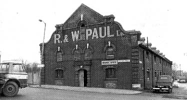
Here's a period photograph of the same building in the
1960s. This shows that there was a line of lettering ending in the
word 'HOUSE', so not an underline at all. [See
the update below for the solution.]
 1960s
image
The Grade II Listing text reads: 'Early C19 Maltings
refashioned
[by J.R. Cattermole] in 1866. Long two storey, with basement and attic
building in brick
with slate gamberel roof with range of gabled dormers and re-fashioned
Dutch gable end of 1866 to road, with rusticated brick quoin pilasters
and central doorway with four first floor round headed windows above
with keyblocks and similar windows in the gable. The side windows and
doorway were altered circa 1866 and have chamfered segmental niched
heads. The adjoining Malt kiln is also probably of circa 1866, brick,
square on plan with tall pyramidal slate roof with cap. Inside the
Maltings there is machinery for the elevators.'
See our Princes Street page for a
timeline on the building of that road and the way it impinged on theses
maltings.
 Photographs
courtesy The Ipswich Society
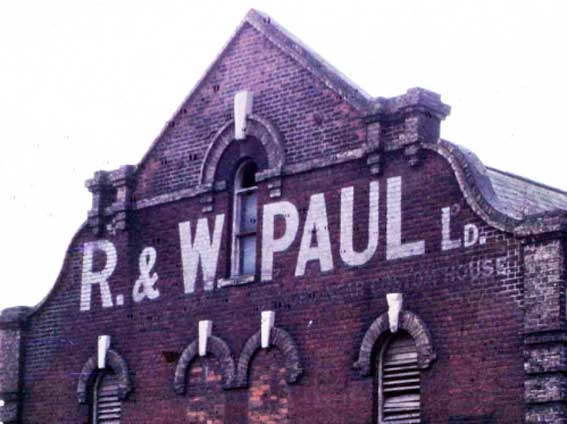
[UPDATE 12.1.2014: This detail
of the Princes Street Paul's
maltings shows the white on red-brick lettering very clearly and
beneath it to the left: 'NEAR CUSTOM HOUSE', so this
lettering advertises the largest of Paul's sites, i.e. at the Wet Dock,
next to the Custom House.]
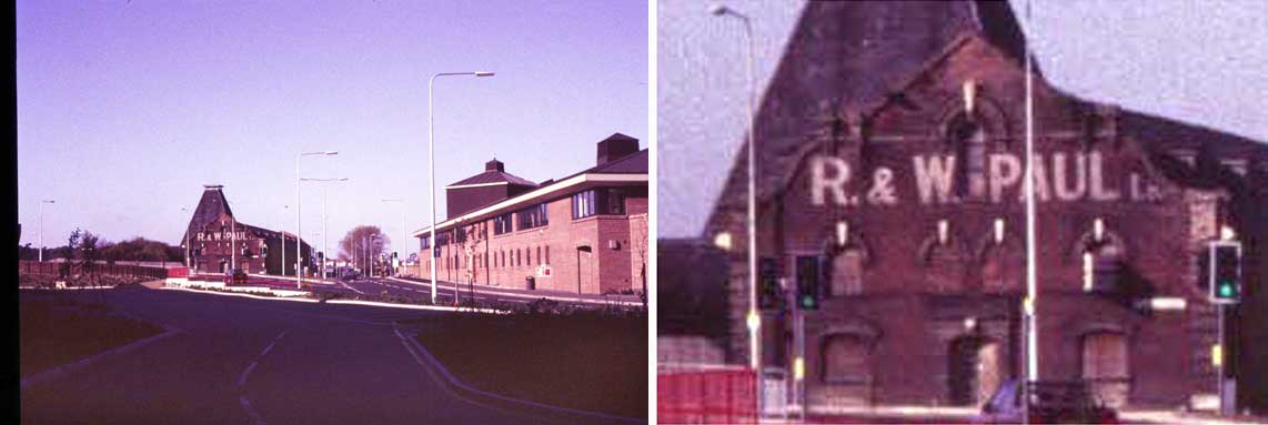
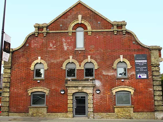
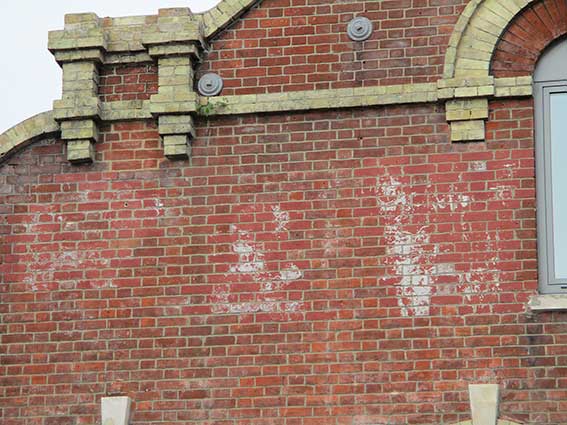
[UPDATE 6.10.2019:
Having stood empty and derelict for a decade,
the Grade II Listed maltings has been transformed, with the complete
stripping-out of the building to reveal its original structure. A new
Atrium area has been formed and the spaces converted to office use.
Some of the original machinery from the R&W Paul maltings has been
preserved in situ. Oh dear, the
building’s original brickwork has been repaired (good) and
steam-cleaned (not so good for the lettering on the facade). The
photographs below show the 'almost gone' state of the 'R&W' part,
with (perhaps common sense prevailed) the remainder still covered in
terra cotta-coloured paint.]
 2019
images
See the
story of Paul's malting company on it own web-page.
There is more information about the philanthropist William
F. Paul on our More almshouses page
regarding the Wm. Paul Tenement Trust.
Related pages:
The Question Mark
Christie's
warehouse
Bridge
Street
College Street
Coprolite
Street
Cranfield's
Flour Mill
Custom House
Trinity
House buoy
Edward
Fison Ltd
Ground-level dockside furniture
on: 'The
island', the northern quays
and Ransome's
Orwell Works
Ipswich
Whaling Station?
Isaac Lord
Neptune Inn
clock, garden
and interior
Isaac
Lord 2
The Island
John Good and Sons
Merchant
seamen's memorial
The Mill
Nova Scotia
House
New Cut East
Quay
nameplates
Ransomes
Steam
Packet Hotel
Stoke
Bridge(s)
Waterfront
Regeneration Scheme
Wolsey's
Gate
A chance to
compare
Wet Dock 1970s with 2004
Wet Dock maps
Davy's
illustration of the laying of the Wet Dock lock foundation stone,
1839
Outside
the Wet Dock
Maritime Ipswich '82
festival
also:
College Street
R. & W. Paul maltings
Stoke
Bridge Maltings
Trinity House Buoy
Old Bell
Home
Please email any comments
and contributions by clicking here.
Search Ipswich
Historic Lettering
©2004 Copyright
throughout the Ipswich
Historic Lettering site: Borin Van Loon
No reproduction of text or images without express written permission

 2003 image
 1970s?
 2003 image
 The
Bull Inn (1960s?)
 1970s
1970s
 Photos courtesy The Ipswich Society
 Image
courtesy John Bulow-Osborne
 Late 19th century courtesy Ipswich Maritime Trust
 2018
images
 2017
images
 1902 map
detail
 2003 images


 'The
Sugar and Almond Specialists' advertisement
 1903 drawings from a selected history of Burton's
 2006
images
  2001 image
 Photograph
courtesy The Ipswich Society
 Photograph
courtesy John Norman
 1960s
image
 Photographs
courtesy The Ipswich Society

 2019
images