Ransomes (Electric
lorry garage
/ warehouse), Wykes Bishop Street (the 4 medieval hamlets),
The Happy Returns pub, Albion Street, Ballast Wharf Walk, Cliff Road, Ransomes lawn mowers, Ransomes today
The Happy Returns pub, Albion Street, Ballast Wharf Walk, Cliff Road, Ransomes lawn mowers, Ransomes today
 See
below
See
belowOne of the greatest names in engineering and a company at the heart of the industrial expansion of Ipswich until the late twentieth century, Ransomes has all but disappeared from modern Ipswich. Disappeared apart, that is, from the name of the industrial estate on the site of their Nacton works: 'Ransomes Europark' and the renamed The Robert Ransome public house on Tower Ramparts (reverted to 'Yates' etc. when Wetherspoons moved out), after the iron-founder who set up his foundry nearby in 1789 (see Plaques). It wasn't until December 2013 that our attention was drawn to a nearby lettered 'Ransomes' warehouse (scroll down for the new images).
Let's go back to the origins of Ransomes...
1789. Robert Ransome moved to Ipswich from Norfolk, establishing the business Ransome and Co. He opened a new foundry on St Margaret's Ditches (which followed the line of the ancient rampart), that is, Old Foundry Road, the present name of which commemorates the site. There is an Ipswich Society Blue plaque to commemorate the original site. Here Ransome made ploughshares; his chilling process to produce cast iron was a technical breakthrough. He obtained several patents for his inventions.
The firm involved his sons Robert Jr and James; also William Cubitt – the famous engineer was employed by the company (1812-17), which had started to build bridges and mill-wrighting. The cast iron version of Stoke Bridge (c.1819) was constructed by William Cubitt. The castings were made in the North of England and construction was by Ransome and Sons
Still under family control after Robert's death in 1830, the foundry moved in 1849 to the eastern quays on the Wet Dock, eventually becoming Ransomes, Sims & Jefferies, making agricultural equipment, forklifts and even aeroplanes in the Great War.
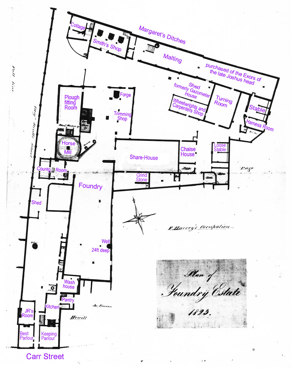
Diagrammatic plan of Robert Ransome's original foundry, Margaret's Ditches (later Old Foundry Road) – 1823
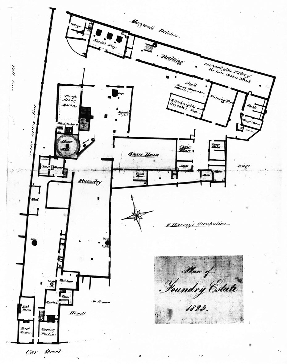
[UPDATE January 2026: 'Hello Borin, have you seen this document before? It seems to be a photo of a plan of Ransomes original Foundry up towards St Margaret's Church south of St Margarets Street, where Colman Street is now.
It's the first time I have seen it represented on anything and dated 1823 seems about right.It was among some photos left behind by an EADT photographer, with other historic Ipswich views, but none of them maps like this. Owen Thurtle'
Many thanks to Owen for finding and sending this foundry plan. We have inserted most of the captions in purple text to make more readable (below).]
Now to the traces of Ransomes' presence in the 21st century...
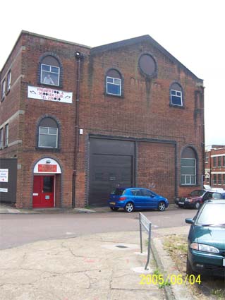
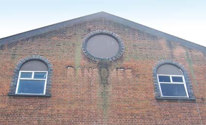
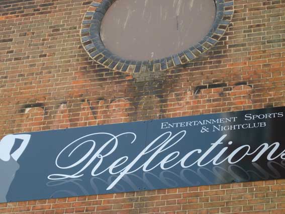
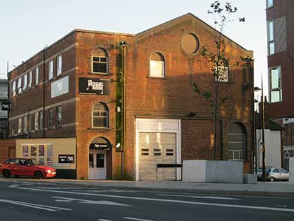
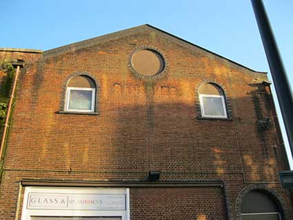
Ransomes electric lorry garage (Premier Pool Club)
However, we initially noticed the shadows of old lettering high up on the building which used to be called Island House in Wykes Bishop Street (see below) off Duke Street. Once the home of Five Castles Press and, until the 1980s, boasting a tiny docklands pub on the opposite corner of the block: The Happy Return (it can still be seen amongst the new dockside regeneration flats ; see below for images). At that time, part of the building was the Premier Pool Club staging occasional concerts by local rock bands, later a social club in part of a building used by Ransomes as garaging for their electric lorries. [See UPDATES below.]
 2004
images
2004
images
Just
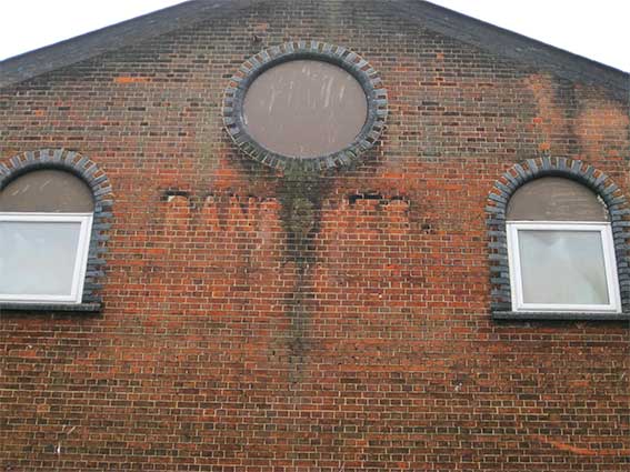
below the central circular window,
which one assumes was left as an open vent in earlier times, the grime
which surrounded the 'RANSOMES' letters still
clings to the brickwork
undimmed by the green and black staining from above. Is there a date
('1819'?) just below it? This doesn't seem right as Ransomes' St
Margaret's Ditches Works Manager William Worby wasn't asked to find a
new overspill site for the company until 1837; the move started in 1841
and was completed eight years later. (see Reading
List for C. & M. Weaver's history of Ransomes). The 'ghost'
date needs more investigation; perhaps '1910'
is more likely. (As you can see in the Ransomes warehouse lettering
below, the date could be '1919'.) See the 1881 map below.
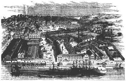
Ransomes' Orwell Works on the east side of the Wet Dock around 1865 (engraving above). The viewpoint is from an imaginary helium balloon which hovers over End Quay or Tovell's Wharf on the 'island'. A steam engine pulls trucks along the dockside tramway while several ships are tied up at the quay. The gasometer is at the right. This was a large site of, in some cases, substantial buildings now all swept away (apart from our example in Duke Street, of course, which would have been further to the right of this image). We assume that Bishop's Hill can be seen rising away from the river basin at the top right; not sure where the windmill would have stood, though (visible on the left horizon).
Ploughs and tillage machinery, steam engines, grass-cutting equipment, trolleybuses, threshers, tractors, combines, electric trucks and more – the range of products made by Ransomes of Ipswich is perhaps the widest of any similar British manufacturer. From Robert Ransome's small workshop in 1789, the company grew to employ 3,000 people and to export all over the world. Having the large Orwell Works between Wherstead Road and New Cut West, then extending to the Nacton Road site on the edge of town, this faded lettering is all that is left of this massive enterprise on the riverside. A note about Robert Ransome's original foundry in Old Foundry Road accompanies the 'Lectures' lettering behind the County Library.
One has to travel to Hadleigh to see Ransomes celebrated in fine style in public lettering on their town pump.
[UPDATE 7.12.2011: "Wet Dock 1936 recollections. I worked at RSJ Orwell Works as office boy at the quayside spares Forwarding Department managed by white haired Spencer Hazell. The quayside entrance featured a large grey painted gate where a weigh-bridge accomodated the railway track. Behind the weigh-bridge was the Engine Turnery. The forwarding department's windows looked across to the wet dock to the Public Warehouse. Next along the quayside was the spares warehouse with Charlie Sergeant in charge then lastly the foundry then the GasWorks with its cranes and heaps of coke. Hope this will fill a little gap. The building with the red door [in the top image above] garaged the Ransomes made electric lorries. Upstairs was a canteen where workers could eat their packed lunches and buy a cup of tea for one old penny which means 240 cups for one pound.Yours sincerely, Tony Adams." Many thanks, Tony.]
[UPDATE 25.11.2012: "I have just discovered your sites on Ransomes and local street names, I feel I must make contact to congratulate you on some superb visual history.
I was born and bred in Ipswich, served my apprenticeship at Ransomes (later, travelling the world for them) and even have a street with my name on it!
As well as working beside the Dock, I kept various boats there for many years and am still having "an affair" with it through the Ipswich Maritime Trust of which you know - and possibly also my brother Stuart who maintains our photographic archive. (15 years ago I organised "Sail Ipswich '97")
A specific detail regarding Ransomes old garage and canteen . I remember (and used) it well. As well as keeping the electric lorries there (I can still hear the drive chains "clicking"!), there was a sideways tilting platform there on which trolley bus stability was tested - there were retaining ropes to catch the bus if it went too far. I was at RS&J from '53 to '66 and was deeply involved in the move from Orwell to Nacton Works. There's a great deal more in my head which someone, somewhere, sometime might value! - Mark Grimwade" We look forward to it.]
 2013 image
Above: the lettering in 2013, partially obscured by a plastic sign.
By 2015, the building is split between Glass & Splashbacks on the ground floor and The Music Room above. The 'Ransomes' lettering shadow is once again claerly visible.
 2015 images
The 2017 photographs (below) show clearly that the some of the upper edges of the 'Ransomes' capitals – in a different font to the example in Cliff Road, shown further down this page – bear traces of a pale paint. Also, the dirt washing down from the central circular window picks out the traces of numerals below the letter 'O'. It looks like a '2' and an '8'. Given that a date of '1928' would be well off-centre, one wonders if this is Shed 28 on the Ransomes Orwell Works complex.
 2017 images
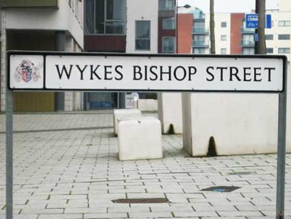
Why 'Wykes Bishop'? The four ancient hamlets of Ipswich
 2014
image
2014
image
Wykes Bishop Street, tiny though it is today, has an interesting derivation. The Bishop's Wick, or Wicks Episcopi as it was sometimes called, was one of the four ancient hamlets of Ipswich: Wykes Bishop, Wykes Ufford (see our St Clement Church page for a passage on this by G.R. Clarke), Stoke and Brookes*). Wykes Bishop is the area to the south of Felixstowe Road which now includes Bishops Hill, extending to the river and including Holywells Park where, for many years it was believed that the residence of the Bishop of Norwich stood within the extensive moat (fed by the local springs) much of which can still to be seen (the Bishops Hill page shows this on a map of the early 1930s). The site would have given the Bishop a splendid view of the town and port. However, ...
... On reading Holywells: home of the Cobbolds by Clive Hodges (see Reading list), his primary research reveals no bishop’s palace in Holywells Park. ‘The early history of Holywells is full of myth and legend. Much of this is derived from a name which the area did not acquire until the early nineteenth century when the Cobbold family moved in, and from the narrative poetry of its first Cobbold mistress, Elizabeth Cobbold. The name Holy Wells, land which had been part of the manor of Wix (or Wykes) Bishop since the thirteen century… The manor of Wix, was gifted by the Crown to the church of Holy Trinity, Norwich on 14 July 1231. The moat, still present, which surrounds the modern play area was probably constructed between this date and the fifteenth century and was long believed to have surrounded a palace owned by the bishops of Norwich.’
Clive Hodges explains how the flat area surrounded (to some extent) by the ‘moat’ was believed to be of great religious and archaeological significance. 21st century archeological investigation ‘… disproved the myth that the bishops of Norwich had ever resided on the site.’
Wykes Bishop continued in the hands of successive bishops from 1235 until the properties of the diocese were exchanged for those of St Benet's Abbey by Henry VIII. Source: Robert Malster's 'A-Z', see Reading List. It is fascinating that all this history is commemorated in the name of this tiny road. In fact, as one can see on the 1881 map of the area, Wykes Bishop Street used to run all the way from Fore Hamlet, with a little kink in the road at Little Wykes Bishop Street and into the 'stub' of the street which survives today. Joseph Pennington's map of 1778 labels Back Hamlet and Fore Hamlet as 'Wykes Ufford Hamlet' and 'Wykes Bishop Hamlet' respectively (and, incidentally, Duke Street as 'Duck Street'); thus, the derivations of the use of 'Hamlet' are preserved in the street names still used today.
(*Brooke’s Hall appears on our Brickyards page under the heading ‘Broomhill brickyard’.)
The four medieval hamlets of Ipswich
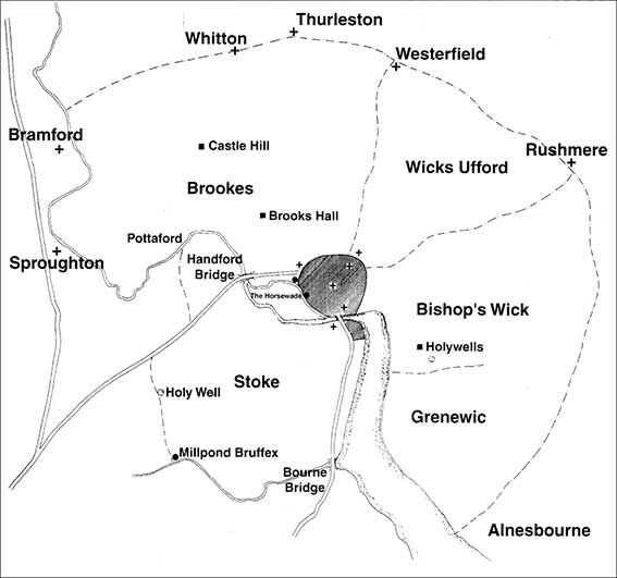
This remarkable map (as at 1086, the date of Little Domesday) is taken from Robert Malster's A history of Ipswich (see Reading list). It shows the medieval borough delineated by the rampart – dug during the Danish occupation of the town AD 879-918 – in the centre (along with part of Over Stoke south of the ford at Great Whip Street, presumably part of the parish of St Peter). There is a certain amount of conjecture about the delineation of the hamlets surrounding the town, however, this is the only map of the area to show them we have seen. It is immediately notable how big the 'hamlets' were. We must not think of these hamlets as in the more modern definition of a small settlement/collection of dwellings without its own church.
Wicks Ufford was later named after the Earls of Ufford, which was an area north-west of Bishops Hill in the direction of Back Hamlet. In 1764 Kirby's Suffolk traveller placed Westerfield Church in Wicks Ufford, so that may have been the outer limit. Rushmere church lies just outside the hamlet.
Wicks Bishop (Wicks Episcope or Bishop's Wick) was an area between Bishops Hill and the river Orwell.
Brookes seems to be the largest in area and just includes the medieval Church of St Botolph (today the Church of St Mary and St Botolph at Whitton, it remains within the Borough boundary), although it excludes a church at Thurleston. Brookes includes the Roman site at Castle Hill and Brooks Hall (which appears on our Brickyards page).
Stoke this hamlet belonged to Ely Abbey and encompassed the fore-runner of St Mary-At-Stoke Church. It ran down the west bank of the Orwell to Belstead Brook, then along that watercourse to a probable mill site (labelled above 'Millpond Bruffex'), then up past the 'Holy Well' (see below) to Crane Hill – a main route into the town still – then off to encompass the land up to today's Hadleigh Road Industrial Estate, then following the Gipping/Orwell back to Stoke Bridge.
Greenwic relates to Greenwich, otherwise known as Greenwich Farm (see Street name derivations). By the time of Domesday in 1086 it seems that Greenwic is outside the borough boundaries, but was later transferred ino the borough.
It's interesting to note that Bob Malster included on the map 'Holywells' in Bishop's Wick, the home of the Cobbold family (the name being an invention applied to their house and park) and a more genuine 'Holy Well' to the western boundary of Stoke hamlet. The latter is probably where a hoard of gold torcs (Iron-Age solid necklaces) was discovered in 1968 (on the site of Holcombe Crescent in Chantry/Belstead Hills).
See also the Grand Ipswich Timeline for context.
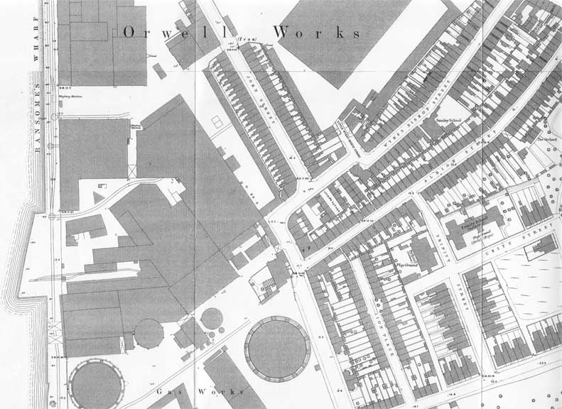
Ransomes on the map
Compare this 1881 detail map with that on our Ransomes site page dated 1867, which includes further analysis of the street names and layout here.
 1881 map
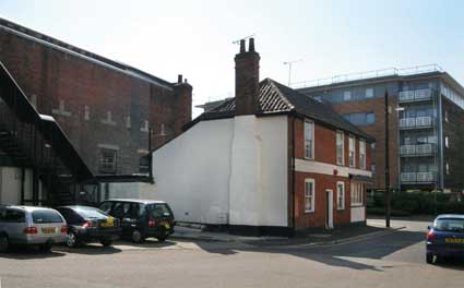
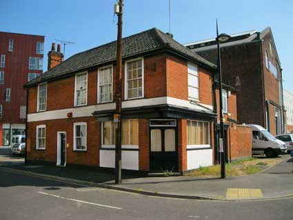
'John Street' running from the top centre of the map detail is a continuation of Duke Street; that it is what we call it today. Duke Street curves eastwards after the Wykes Bishop Street junction and has cut through the housing shown to meet up with a truncated Myrtle Road (visible at bottom right) at a modern roundabout. Focusing on the 'L' shape at the lower end of Wykes Bishop Street (the bit we see today), it is clear that the Ransome Electric Lorry Garage, not surprisingly, did not exist in 1881. There were several small houses in the space it occupies, but the 'P.H.' which is where the former Happy Return public house stands, at number 73 Wykes Bishop Street – at the junction with Albion Street – illustrates the large missing portion of the thoroughfare. The building is still there (see photographs below). One can see how close this site is to the south-east corner of the huge Ransome's Orwell Works, so it would be a reasonable place to put an extra works building.
See also the 1867 map detail of the east bank of the Wet Dock.
The Happy Return public house, 1 Wykes Bishop Street
 2013 images
This Cobbold pub building, standing alone since all the nearby small houses have been removed, is the former The Happy Return. It is recorded as in existence in 1823 (perhaps in an earlier building) and ceased trading as late as 1984 when there were very few regulars remaining in the area. However the pub name 'Happy Return Building' was stencilled on each of the two white panels below the ground floor windows. Even today there is a wrought iron bracket at first floor height near the corner which once supported a pub sign. Opposite the south-west face of this building stood, until the major reshaping and development of Patteson Road, Maude Road and Anchor Square as residential units, stood an imposing facade in red brick and stone which was scandalously destroyed. They put up a modern, pale shadow of the same frontage. It was the southern entrance to Ransome's 'Orwell Iron Works' (as it is shown on the 1867 map).
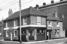 The Happy Return in happier times (1940s).
David Kindred, writing in The Ipswich Star in 2018, points out that 'changes in the road layout have seen this building listed under several different addresses including Duke Street, Holywells Road, Albion Street, John Street, Orwell Works Road and Wykes Bishop Street.
There are scant traces of the northern part of Ransomes' Orwell Works still to be found in the Duke Street car park.
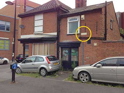
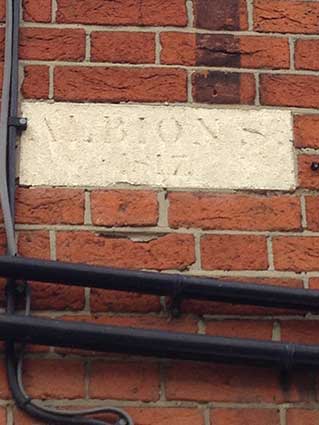
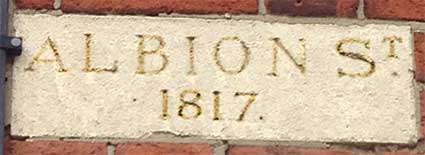
Albion Street
Perfidious Albion! Having explored this building several times in our usual desultory manner, Simon Bole tells of an, as yet, undiscovered street sign actually built in to one of its walls. Indeed it is visible in the 2013 photograph (above).
 2016 images courtesy Simon Bole
Not only that, but it's not in Albion Street today, but in today's "John Street". Many thanks to Simon for spotting it. It would be fortuitous to catch this lettering in raking sunlight.
 enhanced image
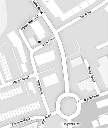
The dramatic reshaping of the roads in this area of St Clement's Parish (see Courts & yards) is illustrated in the comparison of the 1881 map shown above with a present-day street plan (below). The black spot marks the site of the Albion Street sign.
See our Plough Street page for a 1902 map showing the northern ends of Wykes Bishop Street and Albion Street as they once met Fore Hamlet opposite the Gardeners Arms public house.
Ballast Wharf Walk
A few yards away from Wykes Bishop Street is a new lane cut through to serve the 21st century block developments:
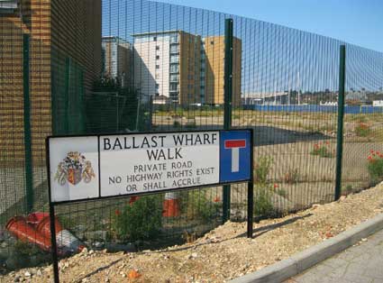
This relates to the name of the wharf across the Wet Dock on 'the island'; see our Wet Dock map.
At the end of this half-built lane is Page Walk, presumably named after Admiral BenjaminPage (1756-1845), who is celebrated by a blue plaque in Tower Street.
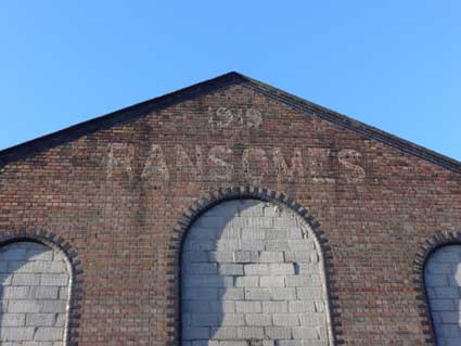
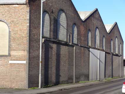
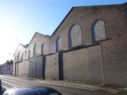
Ransomes warehouse, Cliff Road
 Photographs
courtesy Tim Leggett
Photographs
courtesy Tim Leggett
The third photograph into the sun shows the old Ship Launch pub, now a Chinese restaurant, at far left.
Across the road from The Ship Launch is a sad, isolated pillar box.
 Courtesy
The Ipswich Society
Courtesy
The Ipswich Society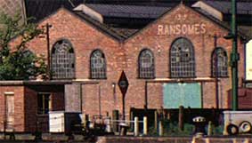
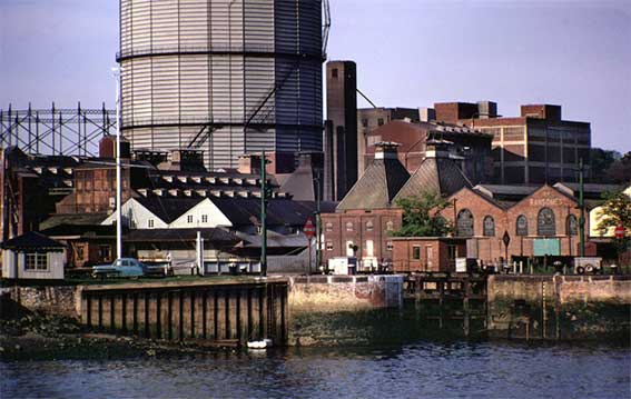
The above photograph from the Ipswich Society's Image Archive (see Links) shows the Wet Dock lock gates in the 1960s, viewed from Griffin Wharf looking north east with the gasworks in the background, notably 'Jumbo' the towering, German-built gasometer (for a 1934 photograph of the gasworks, see our Island page). To the right of the two maltings vented towers are three Ransomes sheds, one painted cream. The close-up shows that the '1919 RANSOMES' lettering was repeated on the dock elevation of the central shed.
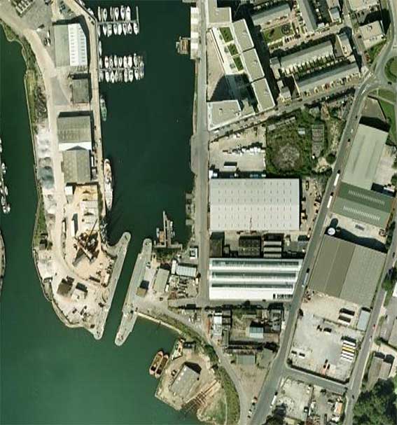 Bird's eye
view
Bird's eye
view
The above aerial view of the area shows the 'skewed' lock gates, fully open at high water (when the river rises to meet the water level in the Wet Dock); to the right of the lock are the three former Ransomes sheds with their eastern ends angled to match the line of Cliff Road. The St Clement's Shipyard existed to the south for centuries and the remnants can still be seen. The short Toller Road runs east-west linking to Holywells Road and the Tolly Cobbold brewery is just south of this image. To the north is Patteson Road with Helena Road on the dockside and the Myrtle Road roundabout at the other. Look just below the centre of Patteson Road and you can still see the circular footprint, mainly green vegetation, where 'Jumbo', the gasometer once stood.
See our Ransome's Orwell Works site page for an 1867 map of this area showing an extensive, tree-lined Promenade all round the southern end of the lock.
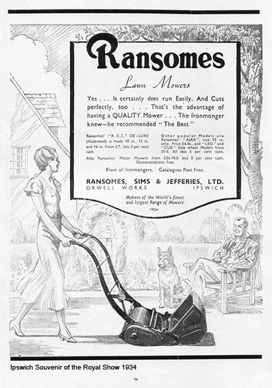
Above: 1934, when a
decent lawnmower was a status symbol and the
lady of the house in shingled hair and cocktail dress would mow the
lawn in front of pipe-smoking hubby and the pet Alsatian. Interesting
use of capital letters in the advertising copy (and don't forget to pay
'cash' for a bargain);-
[UPDATE 1.9.2020: 'Found these two plaques whilst metal detecting in a Suffolk field yesterday. Mounted them for the farmer, but didn't know if they were of interest to you, obviously the Ransomes one. The farmer thinks it may be off a Ransomes Super Cavalier combine. His grandfather had two in the 60s. They were probably fixed with an adhesive of sorts, so my thoughts were they fell off in use. We shall never know. Just another interesting bit of history laying under the ground. Made the farmer smile though, and made me smile when he turned round to his daughter and said, "Your great grandfather used to drive that combine". Regards, Paul Smith.' Thanks to Paul for these finds. The Ransomes Sims & Jefferies plate certainly bears evidence of plough damage.]
 Photograph
courtesy Paul Smith
Photograph
courtesy Paul Smith
Many other examples of Ransomes & Rapier and Ransomes Sims & Jefferies products can be found all over the world.
See our Bourne Park page for more on Ransomes & Rapier.
 Photograph
courtesy John Norman
Photograph
courtesy John Norman
See also our Island page for the R&R swing bridge over the Wet Dock lock.
Ransomes, Sims & Jefferies Ltd history [UPDATED, Jan. 2026 – Thanks to Richard M. Brown.]
R,S&J was the final and probably the most globally successful version of the great Ipswich engineering firm:
1785 Ransome and Co.
1808 Ransome and Son
1818 Ransome and Sons
1825 James and Robert Ransome Gazetted - new partnership
1829 J.R. and A. Ransome
(1836 Ransomes and May) – not sure if this was in 1836; see 1844 notice following:
1844. J. R. and A. Ransome Gazetted (Issue 20302, P51) –
Frederick Ransome left. Ransomes and May stayed in partnership
1851 Ransomes and May Gazetted (Issue 21254, P2634) – GE Prize Medal
1852 Ransomes and May dissolved. Ransomes and Sims formed. Gazetted (Issue 21329 P1737)
1854 Ransomes and Sims
1869 Ransomes, Sims and Head Gazette – Bankruptcy notice (See extract below)
1880 Ransomes, Head and Jefferies Gazette - 1881 Bankruptcy notice (See extract below)
1884 Ransomes, Sims and Jefferies
1864 Gazette (Issue 22868 P3278) Robert Charles, Robert James, and James Edward Ransome - Patent application (402) for “improvements to the manufacture of beams, mould boards, and shares of ploughs.”
1866 Gazette (Issue 23187 P6167). For the 1867 Paris Exhibition, a list of exhibitors to whom space has been allotted by the respective Committees. “ Exhibition list under Group VIII - Classes LXXIV, and XLVIII. - Agricultural Apparatus and Processes used in the Cultivation of Fields and Forests.Ransomes and Sims, Ipswich—Thrashing machines, ploughs, mills &c.” There are other Gazette Editions in which Ransomes and Sims are mentioned re the forthcoming Paris Exhibition.
1868 Gazette (Issue 23430 P5321) Notice of provisional patent protection allowed:— 2873 “And to John Head, of the firm of Ransomes and Sims, of Ipswich, in the county of Suffolk, Engineers, for the invention of “improvements in constructing wire fences, and in apparatus used therein.”—A communication to him from abroad by William Archibald Murray, of Waitahuma, Otago, New Zealand.
“On their several petitions, recorded in the Office of the Commissioners on the 17th day of September, 1868.“
1869 Gazette (Issue 23664. P4336) - Bankruptcy petition filed against William James Scott of Fenchurch St, General Merchant and Importer. Filed by James Allen Ransome, William Dillwyn Sims, Robert Charles Ransome, John Head, and James Edward Ransome. …. Agricultural Implement Makers, and Copartners
1880 (October) Gazette (Issue 24894. P5427) - Bankruptcy petition filed against Edward Gillead Castledine and Percival Charles Natt of Bury St. Edmunds, partners as Ironmongers and Agricultural Implement dealers, sole agents for Ransomes, Sims, and Head.
1881 (September) Gazette (Issue 25016. P4794) - Bankruptcy petition filed against Herbert Henry Morris of Walmer, Carpenter. Filed by Robert Charles Ransome, James Edward Ransome and John Robert Jeffries trading as Ransomes, Head, and Jeffries, of Orwell Works, Ipswich
[Information from Grace's Guide see Links. In January 2026: updated and expanded by Richard M. Brown, who is writing a brief history of Ransomes of Ipswich. Richard has consulted The Gazette: official public record which started in the UK in the mid-17th century; today it is published by The Office for National Statistics.]
They were based at the Orwell Works, Ipswich and were a major British agricultural machinery maker as well as a wide variety of other engineering products. By 1905 the company employed 2,000 people.
 1923
advertisement.
1923
advertisement.
 From
Abbott's Hall collection, Stowmarket
From
Abbott's Hall collection, Stowmarket
Above: a framed crest, used as a transfer on Ransomes' traction engines:
Ransomes today
Many people do not realise that Ransomes, after many ups and downs in the 20th century returned to its original production of lawn mowers. Perhaps fittingly, in the 21st century they trade from Ransomes Europark on the edge of Ipswich. This is an extract from a Textron Inc. (the American owners) web page from 2007:-
"Ransomes Jacobsen Ltd, a Textron Inc. company, celebrated the 175th anniversary of mower production at Ipswich in 2007. Edwin Budding's historic lawnmower design was patented in 1830 and JR & A Ransome were the first company to obtain a licence to manufacture this remarkable invention. The first Ransomes-manufactured machine for domestic use was produced in 1832 and this signalled the beginning of commercial mower production in the UK. Although the company no longer produces domestic lawnmowers they are one of the leading commercial mower manufacturers supplying equipment to golf courses, local authorities, landscape contractors, sports clubs and major sports stadia around the globe.
Ransomes Jacobsen is a subsidiary of Textron Inc., a $10 billion multi-industry company operating in 33 countries with approximately 37,000 employees. The company leverages its global network of aircraft, industrial and finance businesses to provide customers with innovative solutions and services. Textron is known around the world for its powerful brands such as Bell Helicopter, Cessna Aircraft, Jacobsen, Kautex, Lycoming, E-Z-GO and Greenlee, among others.
Significant milestones:
A catalogue from 1851, published for the Great Exhibition in Hyde Park included a 16-inch Budding grass mower priced at £6 5s. Today, the Ransomes HR9016 wide area mower, powered by an 87hp turbo diesel engine and with cutting width of 16 feet retails at £61,592.
In 1904, two years after the introduction of the first motor mower, King Edward VII requested a demonstration of the 30-inch version and two were purchased for the Buckingham Palace gardens.
Ransomes introduce Britain's first battery-powered electric truck in 1920 and in 1926 produce the first mains electric operated lawnmower.
During World War II the Ransomes factories at White City and Ipswich produced bomb trolleys, trailers for 25-pounder guns and parts for Bren gun carriers, Crusader tanks, Rolls-Royce aero engines and Mosquito aircraft.
An extract from the 1954 accounts records sales of 42,500 hand mowers, 1,100 gang mowers and 9,500 motor mowers."
Our Street furniture page shows an 1881 map showing the Ransomes Lawn Mower Works, south of the Corporation Water Works in, logically, Waterworks Street. We have heard reports that Ransomes at one time had lawn mower works on the site of the UCS Art & Design block (formerly the Vicon tractor works) and at the bottom of Bishop's Hill ('White City'). There is a picture on page 120 of the book Ransomes 1789-1989: 200 years of excellence by Carol & Michael Weaver, captioned: 'Assembling hand mowers in the Lawn Mower Works at the bottom of Bishops Hill, 1966'
Related pages:
The Question Mark
Christie's warehouse
Bridge Street
Burton Son & Sanders / Paul's
College Street
Coprolite Street
Cranfield's Flour Mill
Custom House
Trinity House buoys
Edward Fison Ltd
Ground-level dockside furniture on: 'The island', the northern quays and Ransome's Orwell Works
Ipswich Whaling Station?
Isaac Lord
Neptune Inn clock, garden and interior
Isaac Lord 2
The Island
John Good and Sons
Merchant seamen's memorial
The Mill
Nova Scotia House
New Cut East
Quay nameplates
R&W Paul malting company
Ransomes Orwell Works site
Steam Packet Hotel
Stoke Bridge(s)
Waterfront Regeneration Scheme
Wolsey's Gate
A chance to compare Wet Dock 1970s with 2004
Wet Dock maps
Davy's illustration of the laying of the Wet Dock lock foundation stone, 1839
Outside the Wet Dock
Windmills in the Borough of Ipswich
Home
Please email any comments and contributions by clicking here.
Search Ipswich
Historic Lettering
©2004 Copyright throughout the Ipswich Historic Lettering site: Borin Van Loon
No reproduction of text or images without express written permission
Ransomes' Orwell Works on the east side of the Wet Dock around 1865 (engraving above). The viewpoint is from an imaginary helium balloon which hovers over End Quay or Tovell's Wharf on the 'island'. A steam engine pulls trucks along the dockside tramway while several ships are tied up at the quay. The gasometer is at the right. This was a large site of, in some cases, substantial buildings now all swept away (apart from our example in Duke Street, of course, which would have been further to the right of this image). We assume that Bishop's Hill can be seen rising away from the river basin at the top right; not sure where the windmill would have stood, though (visible on the left horizon).
Ploughs and tillage machinery, steam engines, grass-cutting equipment, trolleybuses, threshers, tractors, combines, electric trucks and more – the range of products made by Ransomes of Ipswich is perhaps the widest of any similar British manufacturer. From Robert Ransome's small workshop in 1789, the company grew to employ 3,000 people and to export all over the world. Having the large Orwell Works between Wherstead Road and New Cut West, then extending to the Nacton Road site on the edge of town, this faded lettering is all that is left of this massive enterprise on the riverside. A note about Robert Ransome's original foundry in Old Foundry Road accompanies the 'Lectures' lettering behind the County Library.
One has to travel to Hadleigh to see Ransomes celebrated in fine style in public lettering on their town pump.
[UPDATE 7.12.2011: "Wet Dock 1936 recollections. I worked at RSJ Orwell Works as office boy at the quayside spares Forwarding Department managed by white haired Spencer Hazell. The quayside entrance featured a large grey painted gate where a weigh-bridge accomodated the railway track. Behind the weigh-bridge was the Engine Turnery. The forwarding department's windows looked across to the wet dock to the Public Warehouse. Next along the quayside was the spares warehouse with Charlie Sergeant in charge then lastly the foundry then the GasWorks with its cranes and heaps of coke. Hope this will fill a little gap. The building with the red door [in the top image above] garaged the Ransomes made electric lorries. Upstairs was a canteen where workers could eat their packed lunches and buy a cup of tea for one old penny which means 240 cups for one pound.Yours sincerely, Tony Adams." Many thanks, Tony.]
[UPDATE 25.11.2012: "I have just discovered your sites on Ransomes and local street names, I feel I must make contact to congratulate you on some superb visual history.
I was born and bred in Ipswich, served my apprenticeship at Ransomes (later, travelling the world for them) and even have a street with my name on it!
As well as working beside the Dock, I kept various boats there for many years and am still having "an affair" with it through the Ipswich Maritime Trust of which you know - and possibly also my brother Stuart who maintains our photographic archive. (15 years ago I organised "Sail Ipswich '97")
A specific detail regarding Ransomes old garage and canteen . I remember (and used) it well. As well as keeping the electric lorries there (I can still hear the drive chains "clicking"!), there was a sideways tilting platform there on which trolley bus stability was tested - there were retaining ropes to catch the bus if it went too far. I was at RS&J from '53 to '66 and was deeply involved in the move from Orwell to Nacton Works. There's a great deal more in my head which someone, somewhere, sometime might value! - Mark Grimwade" We look forward to it.]
2013 imageAbove: the lettering in 2013, partially obscured by a plastic sign.
By 2015, the building is split between Glass & Splashbacks on the ground floor and The Music Room above. The 'Ransomes' lettering shadow is once again claerly visible.
2015 imagesThe 2017 photographs (below) show clearly that the some of the upper edges of the 'Ransomes' capitals – in a different font to the example in Cliff Road, shown further down this page – bear traces of a pale paint. Also, the dirt washing down from the central circular window picks out the traces of numerals below the letter 'O'. It looks like a '2' and an '8'. Given that a date of '1928' would be well off-centre, one wonders if this is Shed 28 on the Ransomes Orwell Works complex.
2017 imagesWhy 'Wykes Bishop'? The four ancient hamlets of Ipswich
2014
imageWykes Bishop Street, tiny though it is today, has an interesting derivation. The Bishop's Wick, or Wicks Episcopi as it was sometimes called, was one of the four ancient hamlets of Ipswich: Wykes Bishop, Wykes Ufford (see our St Clement Church page for a passage on this by G.R. Clarke), Stoke and Brookes*). Wykes Bishop is the area to the south of Felixstowe Road which now includes Bishops Hill, extending to the river and including Holywells Park where, for many years it was believed that the residence of the Bishop of Norwich stood within the extensive moat (fed by the local springs) much of which can still to be seen (the Bishops Hill page shows this on a map of the early 1930s). The site would have given the Bishop a splendid view of the town and port. However, ...
... On reading Holywells: home of the Cobbolds by Clive Hodges (see Reading list), his primary research reveals no bishop’s palace in Holywells Park. ‘The early history of Holywells is full of myth and legend. Much of this is derived from a name which the area did not acquire until the early nineteenth century when the Cobbold family moved in, and from the narrative poetry of its first Cobbold mistress, Elizabeth Cobbold. The name Holy Wells, land which had been part of the manor of Wix (or Wykes) Bishop since the thirteen century… The manor of Wix, was gifted by the Crown to the church of Holy Trinity, Norwich on 14 July 1231. The moat, still present, which surrounds the modern play area was probably constructed between this date and the fifteenth century and was long believed to have surrounded a palace owned by the bishops of Norwich.’
Clive Hodges explains how the flat area surrounded (to some extent) by the ‘moat’ was believed to be of great religious and archaeological significance. 21st century archeological investigation ‘… disproved the myth that the bishops of Norwich had ever resided on the site.’
Wykes Bishop continued in the hands of successive bishops from 1235 until the properties of the diocese were exchanged for those of St Benet's Abbey by Henry VIII. Source: Robert Malster's 'A-Z', see Reading List. It is fascinating that all this history is commemorated in the name of this tiny road. In fact, as one can see on the 1881 map of the area, Wykes Bishop Street used to run all the way from Fore Hamlet, with a little kink in the road at Little Wykes Bishop Street and into the 'stub' of the street which survives today. Joseph Pennington's map of 1778 labels Back Hamlet and Fore Hamlet as 'Wykes Ufford Hamlet' and 'Wykes Bishop Hamlet' respectively (and, incidentally, Duke Street as 'Duck Street'); thus, the derivations of the use of 'Hamlet' are preserved in the street names still used today.
(*Brooke’s Hall appears on our Brickyards page under the heading ‘Broomhill brickyard’.)
The four medieval hamlets of Ipswich
This remarkable map (as at 1086, the date of Little Domesday) is taken from Robert Malster's A history of Ipswich (see Reading list). It shows the medieval borough delineated by the rampart – dug during the Danish occupation of the town AD 879-918 – in the centre (along with part of Over Stoke south of the ford at Great Whip Street, presumably part of the parish of St Peter). There is a certain amount of conjecture about the delineation of the hamlets surrounding the town, however, this is the only map of the area to show them we have seen. It is immediately notable how big the 'hamlets' were. We must not think of these hamlets as in the more modern definition of a small settlement/collection of dwellings without its own church.
Wicks Ufford was later named after the Earls of Ufford, which was an area north-west of Bishops Hill in the direction of Back Hamlet. In 1764 Kirby's Suffolk traveller placed Westerfield Church in Wicks Ufford, so that may have been the outer limit. Rushmere church lies just outside the hamlet.
Wicks Bishop (Wicks Episcope or Bishop's Wick) was an area between Bishops Hill and the river Orwell.
Brookes seems to be the largest in area and just includes the medieval Church of St Botolph (today the Church of St Mary and St Botolph at Whitton, it remains within the Borough boundary), although it excludes a church at Thurleston. Brookes includes the Roman site at Castle Hill and Brooks Hall (which appears on our Brickyards page).
Stoke this hamlet belonged to Ely Abbey and encompassed the fore-runner of St Mary-At-Stoke Church. It ran down the west bank of the Orwell to Belstead Brook, then along that watercourse to a probable mill site (labelled above 'Millpond Bruffex'), then up past the 'Holy Well' (see below) to Crane Hill – a main route into the town still – then off to encompass the land up to today's Hadleigh Road Industrial Estate, then following the Gipping/Orwell back to Stoke Bridge.
Greenwic relates to Greenwich, otherwise known as Greenwich Farm (see Street name derivations). By the time of Domesday in 1086 it seems that Greenwic is outside the borough boundaries, but was later transferred ino the borough.
It's interesting to note that Bob Malster included on the map 'Holywells' in Bishop's Wick, the home of the Cobbold family (the name being an invention applied to their house and park) and a more genuine 'Holy Well' to the western boundary of Stoke hamlet. The latter is probably where a hoard of gold torcs (Iron-Age solid necklaces) was discovered in 1968 (on the site of Holcombe Crescent in Chantry/Belstead Hills).
See also the Grand Ipswich Timeline for context.
Ransomes on the map
Compare this 1881 detail map with that on our Ransomes site page dated 1867, which includes further analysis of the street names and layout here.
1881 map'John Street' running from the top centre of the map detail is a continuation of Duke Street; that it is what we call it today. Duke Street curves eastwards after the Wykes Bishop Street junction and has cut through the housing shown to meet up with a truncated Myrtle Road (visible at bottom right) at a modern roundabout. Focusing on the 'L' shape at the lower end of Wykes Bishop Street (the bit we see today), it is clear that the Ransome Electric Lorry Garage, not surprisingly, did not exist in 1881. There were several small houses in the space it occupies, but the 'P.H.' which is where the former Happy Return public house stands, at number 73 Wykes Bishop Street – at the junction with Albion Street – illustrates the large missing portion of the thoroughfare. The building is still there (see photographs below). One can see how close this site is to the south-east corner of the huge Ransome's Orwell Works, so it would be a reasonable place to put an extra works building.
See also the 1867 map detail of the east bank of the Wet Dock.
The Happy Return public house, 1 Wykes Bishop Street
2013 imagesThis Cobbold pub building, standing alone since all the nearby small houses have been removed, is the former The Happy Return. It is recorded as in existence in 1823 (perhaps in an earlier building) and ceased trading as late as 1984 when there were very few regulars remaining in the area. However the pub name 'Happy Return Building' was stencilled on each of the two white panels below the ground floor windows. Even today there is a wrought iron bracket at first floor height near the corner which once supported a pub sign. Opposite the south-west face of this building stood, until the major reshaping and development of Patteson Road, Maude Road and Anchor Square as residential units, stood an imposing facade in red brick and stone which was scandalously destroyed. They put up a modern, pale shadow of the same frontage. It was the southern entrance to Ransome's 'Orwell Iron Works' (as it is shown on the 1867 map).
The Happy Return in happier times (1940s).David Kindred, writing in The Ipswich Star in 2018, points out that 'changes in the road layout have seen this building listed under several different addresses including Duke Street, Holywells Road, Albion Street, John Street, Orwell Works Road and Wykes Bishop Street.
There are scant traces of the northern part of Ransomes' Orwell Works still to be found in the Duke Street car park.
Albion Street
Perfidious Albion! Having explored this building several times in our usual desultory manner, Simon Bole tells of an, as yet, undiscovered street sign actually built in to one of its walls. Indeed it is visible in the 2013 photograph (above).
2016 images courtesy Simon Bole Not only that, but it's not in Albion Street today, but in today's "John Street". Many thanks to Simon for spotting it. It would be fortuitous to catch this lettering in raking sunlight.
enhanced imageThe dramatic reshaping of the roads in this area of St Clement's Parish (see Courts & yards) is illustrated in the comparison of the 1881 map shown above with a present-day street plan (below). The black spot marks the site of the Albion Street sign.
See our Plough Street page for a 1902 map showing the northern ends of Wykes Bishop Street and Albion Street as they once met Fore Hamlet opposite the Gardeners Arms public house.
Ballast Wharf Walk
A few yards away from Wykes Bishop Street is a new lane cut through to serve the 21st century block developments:
'BALLAST WHARF WALK'
This relates to the name of the wharf across the Wet Dock on 'the island'; see our Wet Dock map.
At the end of this half-built lane is Page Walk, presumably named after Admiral BenjaminPage (1756-1845), who is celebrated by a blue plaque in Tower Street.
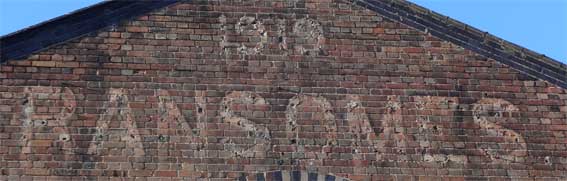
Ransomes warehouse, Cliff Road
'1919
RANSOMES.'
... complete with full stop. As in the Electric lorry depot, the
company left its mark by the
dirt left behind by the characters of the name, how very odd. We are
indebted to Tim Leggett for these excellent (not to mention surprising)
photographs. The second image shows the corner of Cliff Road and Ship
Launch Road,
the street nameplate barely readable in the bright sunshine. This ghost
sign is in a different font to the example in Wykes Bishop Street
(further up this page) and the 1919 date suggests that this is a later
structure.RANSOMES.'
Photographs
courtesy Tim LeggettThe third photograph into the sun shows the old Ship Launch pub, now a Chinese restaurant, at far left.
Across the road from The Ship Launch is a sad, isolated pillar box.
Courtesy
The Ipswich SocietyThe above photograph from the Ipswich Society's Image Archive (see Links) shows the Wet Dock lock gates in the 1960s, viewed from Griffin Wharf looking north east with the gasworks in the background, notably 'Jumbo' the towering, German-built gasometer (for a 1934 photograph of the gasworks, see our Island page). To the right of the two maltings vented towers are three Ransomes sheds, one painted cream. The close-up shows that the '1919 RANSOMES' lettering was repeated on the dock elevation of the central shed.
Bird's eye
viewThe above aerial view of the area shows the 'skewed' lock gates, fully open at high water (when the river rises to meet the water level in the Wet Dock); to the right of the lock are the three former Ransomes sheds with their eastern ends angled to match the line of Cliff Road. The St Clement's Shipyard existed to the south for centuries and the remnants can still be seen. The short Toller Road runs east-west linking to Holywells Road and the Tolly Cobbold brewery is just south of this image. To the north is Patteson Road with Helena Road on the dockside and the Myrtle Road roundabout at the other. Look just below the centre of Patteson Road and you can still see the circular footprint, mainly green vegetation, where 'Jumbo', the gasometer once stood.
See our Ransome's Orwell Works site page for an 1867 map of this area showing an extensive, tree-lined Promenade all round the southern end of the lock.
'RANSOMES
Lawn Mowers
Yes... It certainly does run Easily. And Cuts
perfectly, too ... That's the advantage of
having a QUALITY Mower ... The Ironmonger
knew – he recommended "The Best"
Ransomes' "R.S.J." DE-LUXE (Illustrated) is made 10 in., 12 in. and 14 in. From £7, less 5 per cent cash.
Other popular Models are Ransomes' "AJAX", size 12 in. only. Price £4.4s., and "LEO" and "CUB" Side wheel Models from 31/6. All less 5 per cent cash.
Also Ransomes' Motor Mowers from £24.10.0 less 5 per cent cash.
Demonstrations free.
From all Ironmongers. Catalogues Post Free.
RANSOMES, SIMS & JEFFERIES, LTD.
ORWELL WORKS IPSWICH
Makers of the World's finest and largest Range of Mowers'
[UPDATE 22.9.2019: 'Good
evening Borin. Saw these today and thought of you. Up to you whether
you include them on your marvellous website. Seen at Dunvegan Castle on
the Isle of Skye. Regards, Paul Smith.' Many thanks to Paul for tracing examples
of Ransomes machines in this corner of the British Isles.]Lawn Mowers
Yes... It certainly does run Easily. And Cuts
perfectly, too ... That's the advantage of
having a QUALITY Mower ... The Ironmonger
knew – he recommended "The Best"
Ransomes' "R.S.J." DE-LUXE (Illustrated) is made 10 in., 12 in. and 14 in. From £7, less 5 per cent cash.
Other popular Models are Ransomes' "AJAX", size 12 in. only. Price £4.4s., and "LEO" and "CUB" Side wheel Models from 31/6. All less 5 per cent cash.
Also Ransomes' Motor Mowers from £24.10.0 less 5 per cent cash.
Demonstrations free.
From all Ironmongers. Catalogues Post Free.
RANSOMES, SIMS & JEFFERIES, LTD.
ORWELL WORKS IPSWICH
Makers of the World's finest and largest Range of Mowers'
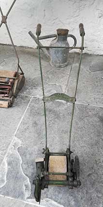
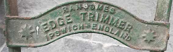
'RANSOMES
EDGE TRIMMER
IPSWICH ENGLAND'
EDGE TRIMMER
IPSWICH ENGLAND'
Ransomes Edge
Trimmer. Ipswich. England. Steel and wood. Green and Red paint. 1920s.
In 1826 in the first volume of ‘The Gardeners Magazine’, Charles McIntosh described a new Edging Iron of his invention with a coulter or cutting edge fixed to a wheeled frame. In the same year a French annual ‘Le Bon Jardinier’ illustrated a verge cutter consisting of a cutting wheel on a straight handle. In 1880 a wheeled edger with shears was patented by P Adie. [Information from Old Garden Tools virtual museum.]
In 1826 in the first volume of ‘The Gardeners Magazine’, Charles McIntosh described a new Edging Iron of his invention with a coulter or cutting edge fixed to a wheeled frame. In the same year a French annual ‘Le Bon Jardinier’ illustrated a verge cutter consisting of a cutting wheel on a straight handle. In 1880 a wheeled edger with shears was patented by P Adie. [Information from Old Garden Tools virtual museum.]
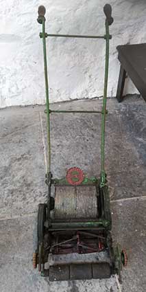
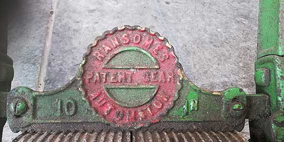
'RANSOMES
PATENT GEAR
10 AUTOMATON IN'
In 1897 Ransomes introduced two new mowers to replace its
existing Automaton models. The Patent Chain Automaton (PCA) and the
Patent Gear Automaton (PGA) were destined to become some of the most
popular hand mowers of the period leading up to the First World War.
Outwardly the mowers appear similar to the earlier models although
there were a number of enhancements:PATENT GEAR
10 AUTOMATON IN'
- the rear driving roller was ribbed circumferentially to help prevent the mower slipping sideways on slopes
- the cutting cylinder was double-angled (the left and right halves angled towards the centre) to deliver the clippings more evenly into the grass box
- the front roller was more easily adjusted through the incorporation of a bell shaped hand wheel that eliminated the need for a spanner
- the scraper plate behind the rear roller was more elaborate to incorporate the name of the machine. The central round motif was repeated as a transfer on the grass box.
[UPDATE 1.9.2020: 'Found these two plaques whilst metal detecting in a Suffolk field yesterday. Mounted them for the farmer, but didn't know if they were of interest to you, obviously the Ransomes one. The farmer thinks it may be off a Ransomes Super Cavalier combine. His grandfather had two in the 60s. They were probably fixed with an adhesive of sorts, so my thoughts were they fell off in use. We shall never know. Just another interesting bit of history laying under the ground. Made the farmer smile though, and made me smile when he turned round to his daughter and said, "Your great grandfather used to drive that combine". Regards, Paul Smith.' Thanks to Paul for these finds. The Ransomes Sims & Jefferies plate certainly bears evidence of plough damage.]
Photograph
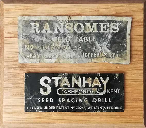
courtesy Paul Smith'RANSOMES
FEED TABLE
NO. 10273068
RANSOMES SIMS & JEFFERIES LTD.'
FEED TABLE
NO. 10273068
RANSOMES SIMS & JEFFERIES LTD.'
It is remarkable that the
impressed product number is still clearly readable.
Many other examples of Ransomes & Rapier and Ransomes Sims & Jefferies products can be found all over the world.
See our Bourne Park page for more on Ransomes & Rapier.
Photograph
courtesy John NormanSee also our Island page for the R&R swing bridge over the Wet Dock lock.
Ransomes, Sims & Jefferies Ltd history [UPDATED, Jan. 2026 – Thanks to Richard M. Brown.]
R,S&J was the final and probably the most globally successful version of the great Ipswich engineering firm:
1785 Ransome and Co.
1808 Ransome and Son
1818 Ransome and Sons
1825 James and Robert Ransome Gazetted - new partnership
1829 J.R. and A. Ransome
(1836 Ransomes and May) – not sure if this was in 1836; see 1844 notice following:
1844. J. R. and A. Ransome Gazetted (Issue 20302, P51) –
Frederick Ransome left. Ransomes and May stayed in partnership
1851 Ransomes and May Gazetted (Issue 21254, P2634) – GE Prize Medal
1852 Ransomes and May dissolved. Ransomes and Sims formed. Gazetted (Issue 21329 P1737)
1854 Ransomes and Sims
1869 Ransomes, Sims and Head Gazette – Bankruptcy notice (See extract below)
1880 Ransomes, Head and Jefferies Gazette - 1881 Bankruptcy notice (See extract below)
1884 Ransomes, Sims and Jefferies
1864 Gazette (Issue 22868 P3278) Robert Charles, Robert James, and James Edward Ransome - Patent application (402) for “improvements to the manufacture of beams, mould boards, and shares of ploughs.”
1866 Gazette (Issue 23187 P6167). For the 1867 Paris Exhibition, a list of exhibitors to whom space has been allotted by the respective Committees. “ Exhibition list under Group VIII - Classes LXXIV, and XLVIII. - Agricultural Apparatus and Processes used in the Cultivation of Fields and Forests.Ransomes and Sims, Ipswich—Thrashing machines, ploughs, mills &c.” There are other Gazette Editions in which Ransomes and Sims are mentioned re the forthcoming Paris Exhibition.
1868 Gazette (Issue 23430 P5321) Notice of provisional patent protection allowed:— 2873 “And to John Head, of the firm of Ransomes and Sims, of Ipswich, in the county of Suffolk, Engineers, for the invention of “improvements in constructing wire fences, and in apparatus used therein.”—A communication to him from abroad by William Archibald Murray, of Waitahuma, Otago, New Zealand.
“On their several petitions, recorded in the Office of the Commissioners on the 17th day of September, 1868.“
1869 Gazette (Issue 23664. P4336) - Bankruptcy petition filed against William James Scott of Fenchurch St, General Merchant and Importer. Filed by James Allen Ransome, William Dillwyn Sims, Robert Charles Ransome, John Head, and James Edward Ransome. …. Agricultural Implement Makers, and Copartners
1880 (October) Gazette (Issue 24894. P5427) - Bankruptcy petition filed against Edward Gillead Castledine and Percival Charles Natt of Bury St. Edmunds, partners as Ironmongers and Agricultural Implement dealers, sole agents for Ransomes, Sims, and Head.
1881 (September) Gazette (Issue 25016. P4794) - Bankruptcy petition filed against Herbert Henry Morris of Walmer, Carpenter. Filed by Robert Charles Ransome, James Edward Ransome and John Robert Jeffries trading as Ransomes, Head, and Jeffries, of Orwell Works, Ipswich
[Information from Grace's Guide see Links. In January 2026: updated and expanded by Richard M. Brown, who is writing a brief history of Ransomes of Ipswich. Richard has consulted The Gazette: official public record which started in the UK in the mid-17th century; today it is published by The Office for National Statistics.]
They were based at the Orwell Works, Ipswich and were a major British agricultural machinery maker as well as a wide variety of other engineering products. By 1905 the company employed 2,000 people.
1923
advertisement.From
Abbott's Hall collection, StowmarketAbove: a framed crest, used as a transfer on Ransomes' traction engines:
'RANSOMES, SIMS &
JEFFERIES LD.
PRIZE MEDALS
IPSWICH ENGLAND'
The Ipswich Borough coat of arms
appears at the top of the circle.PRIZE MEDALS
IPSWICH ENGLAND'
Ransomes today
Many people do not realise that Ransomes, after many ups and downs in the 20th century returned to its original production of lawn mowers. Perhaps fittingly, in the 21st century they trade from Ransomes Europark on the edge of Ipswich. This is an extract from a Textron Inc. (the American owners) web page from 2007:-
"Ransomes Jacobsen Ltd, a Textron Inc. company, celebrated the 175th anniversary of mower production at Ipswich in 2007. Edwin Budding's historic lawnmower design was patented in 1830 and JR & A Ransome were the first company to obtain a licence to manufacture this remarkable invention. The first Ransomes-manufactured machine for domestic use was produced in 1832 and this signalled the beginning of commercial mower production in the UK. Although the company no longer produces domestic lawnmowers they are one of the leading commercial mower manufacturers supplying equipment to golf courses, local authorities, landscape contractors, sports clubs and major sports stadia around the globe.
Ransomes Jacobsen is a subsidiary of Textron Inc., a $10 billion multi-industry company operating in 33 countries with approximately 37,000 employees. The company leverages its global network of aircraft, industrial and finance businesses to provide customers with innovative solutions and services. Textron is known around the world for its powerful brands such as Bell Helicopter, Cessna Aircraft, Jacobsen, Kautex, Lycoming, E-Z-GO and Greenlee, among others.
Significant milestones:
- Production of the Ransomes Budding begins in Ipswich in 1832.
- Innovations quickly follow and by 1852 some 1,500 improved versions of the 21-inch mower had been produced. In 1870 the range was extended with the introduction of horse drawn mowers.
- Shortly after the dawn of the 20th century, Ransomes engineers produced the world's first petrol driven lawn mower. This single innovation in 1902 was to change the way that grass was cut for ever.
- By the end of the 1920s the Ransomes catalogue featured Quintuple and Septuple gang mowers, using cutting cylinders from horse-drawn triple mowers ganged into combinations of five and seven units.
- The new White City works in West London opened in 1937 to meet the growing demand for Ransomes mowers.
- In the late 1930s greenkeepers began to overcome their reluctance to use petrol-driven machines and this was as a result of the introduction of the Overgreen, a machine featuring a power unit with large pneumatic tyres that pulled three Certes cutting units and enabled a single greenkeeper to cut 18 greens in a day.
- After World War II a number of new machines were introduced including the Auto Certes, a mower that developed a worldwide reputation for its exceptionally fine cut.
- 1964 saw the introduction of the Ransomes Quint, the world's first tractor-mounted, power-driven five unit gang mower. In the same year, the Motor Triple was launched; a highly manoeuvrable, high output mower which elevated Ransomes to the forefront of the European professional turf care market.
- In 1978 Ransomes acquired an interest in an American rotary mower manufacturer, which subsequently became a wholly owned subsidiary, Ransomes Inc. The result of this fruitful union was the Motor 180, with power units manufactured in the USA and cutting units built in Ipswich.
- The Motor 213, a hydraulically driven triple reel mower for the local authority market was launched in 1982. This high work rate, ride-on triplex mower heralded the change from large scale pedestrian operated mowing practices to more productive and cost effective maintenance of roadside verges and housing areas.
- 1988 and Ransomes acquires Cushman Ryan, the US manufacturer, which provided access to the Cushman Turf Truckster and its wide range of accessories for topdressing, spraying, aeration and other maintenance duties on sports turf areas.
- The E-Plex is introduced in 1994, the world's first electric ride-on triplex greens mower, providing noise and pollution free mowing of fine turf, particularly golf greens in suburban areas.
- In 1998 Textron Inc., the multi-industry US company operating in 33 countries with approximately 37,000 employees, acquires Ransomes plc and establishes Textron Turf Care & Specialty Products group.
- Company re-branded in 2001 as Ransomes Jacobsen Ltd, focusing on core brands: Ransomes for local authority and municipal mowers, Jacobsen for the golf sector.
- 2003 sees the launch of dedicated environmental programme under "Driving Environmental Performance" strapline.
- 2004 and the innovative remote controlled bank mower "Spider" is launched to wide acclaim and wins multiple industry awards.
- In July 2006 Ransomes Jacobsen signs contract with the PGA to become Official Turf Equipment Supplier. The following month they also become a Lead Partner in Golf Environment Europe, the pan European initiative working to promote environmental sustainability in golf.
A catalogue from 1851, published for the Great Exhibition in Hyde Park included a 16-inch Budding grass mower priced at £6 5s. Today, the Ransomes HR9016 wide area mower, powered by an 87hp turbo diesel engine and with cutting width of 16 feet retails at £61,592.
In 1904, two years after the introduction of the first motor mower, King Edward VII requested a demonstration of the 30-inch version and two were purchased for the Buckingham Palace gardens.
Ransomes introduce Britain's first battery-powered electric truck in 1920 and in 1926 produce the first mains electric operated lawnmower.
During World War II the Ransomes factories at White City and Ipswich produced bomb trolleys, trailers for 25-pounder guns and parts for Bren gun carriers, Crusader tanks, Rolls-Royce aero engines and Mosquito aircraft.
An extract from the 1954 accounts records sales of 42,500 hand mowers, 1,100 gang mowers and 9,500 motor mowers."
Our Street furniture page shows an 1881 map showing the Ransomes Lawn Mower Works, south of the Corporation Water Works in, logically, Waterworks Street. We have heard reports that Ransomes at one time had lawn mower works on the site of the UCS Art & Design block (formerly the Vicon tractor works) and at the bottom of Bishop's Hill ('White City'). There is a picture on page 120 of the book Ransomes 1789-1989: 200 years of excellence by Carol & Michael Weaver, captioned: 'Assembling hand mowers in the Lawn Mower Works at the bottom of Bishops Hill, 1966'
Related pages:
The Question Mark
Christie's warehouse
Bridge Street
Burton Son & Sanders / Paul's
College Street
Coprolite Street
Cranfield's Flour Mill
Custom House
Trinity House buoys
Edward Fison Ltd
Ground-level dockside furniture on: 'The island', the northern quays and Ransome's Orwell Works
Ipswich Whaling Station?
Isaac Lord
Neptune Inn clock, garden and interior
Isaac Lord 2
The Island
John Good and Sons
Merchant seamen's memorial
The Mill
Nova Scotia House
New Cut East
Quay nameplates
R&W Paul malting company
Ransomes Orwell Works site
Steam Packet Hotel
Stoke Bridge(s)
Waterfront Regeneration Scheme
Wolsey's Gate
A chance to compare Wet Dock 1970s with 2004
Wet Dock maps
Davy's illustration of the laying of the Wet Dock lock foundation stone, 1839
Outside the Wet Dock
Windmills in the Borough of Ipswich
©2004 Copyright throughout the Ipswich Historic Lettering site: Borin Van Loon
No reproduction of text or images without express written permission