Muriel Clegg (see Reading List)
from The way we went (1989)
on the creation of Paving and Lighting
Commissioners in Ipswich:
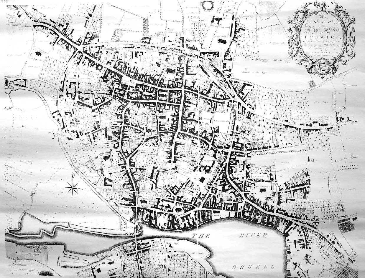
"Conditions of town life were changing rapidly [by the mid-19th century] and each change demanded powers of control beyond the scope of existing municipal authorities. Population was increasing and with it a sudden density of housing in central areas, soon followed by an expansion into what had once been countryside. In Ipswich nothing brings home more vividly the impact of these changes than a comparison of Pennington's map of Ipswich, 1778, with that of White 1867. The large gardens, orchards and open spaces of 1778 have given way to the dense housing pattern of 1867."
"Conditions of town life were changing rapidly [by the mid-19th century] and each change demanded powers of control beyond the scope of existing municipal authorities. Population was increasing and with it a sudden density of housing in central areas, soon followed by an expansion into what had once been countryside. In Ipswich nothing brings home more vividly the impact of these changes than a comparison of Pennington's map of Ipswich, 1778, with that of White 1867. The large gardens, orchards and open spaces of 1778 have given way to the dense housing pattern of 1867."
Detail of the 1778 map
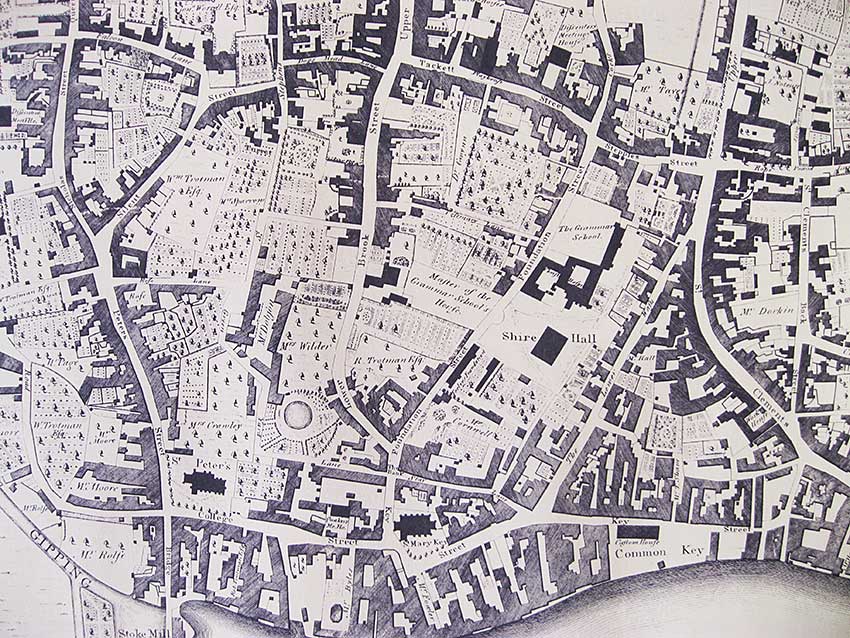
Notes on the map detail
1. The above detail shows Pennington's 1778 map of the southern town centre down to the docks. From top left to top right the linking roads are: Boat Lane (partly today's Friars Street), Falcon Lane, Silent Street, Dogs Head Lane, Tacket Street (showing the 'Playhouse'), Stepples Street (today's Orwell Place) and Rope Lane (this part is today's Eagle Street).
2. To the right The Upper Wash (Upper Orwell Street, part of which at that time was lined with trees (as was part of Rope Lane) runs south to meet The Lower Wash (the narrower Lower Orwell Street) at the sharp angled junction (later known as Sneezum's Corner), well below the Stepples Street junction. 'Fore Street' is nowhere to be seen in 1778 and the curving road running south-east from that angle junction is labelled 'St Clements Lane'.
3. At the far right, the road running south from Rope Lane (on the line of today's Waterworks Street) is 'St Clements Back Street', the lower part later named Angel Lane, after the inn on the junction.
4. Note the line of Key Street running past the timber-framed Old Custom House with its colonnade, set back from The Crane on Common Quay ('Common Key'). It proceeds round the tree-lined St Mary Key churchyard and north past the church itself meeting Star Lane, the junction marked 'The Bank'; Foundation and Lower Brook Streets lead north from this, as today. The short north-south stretch of Key Street shown here has been called Bank Street and Foundation Street amongst other things.
5. Star Lane also has an easterly junction with Key Street and, after Foundation Street, the lane becomes Green Yard Lane which turns north after a garden with a circular pond following the line of today's Turret Lane. After Rose Lane runs off to the left it becomes St Stephens Lane, eventually reaching the church after which it is named.
6. Between the upper parts of St Stephens Lane and Silent Street, the legend 'Turret' can be seen. This is undoubtedly Turret House (demolished 1843) which gives its name to today's Turret Lane. See our page on Wolsey's College for a map of the pre-1528 period showing Turret House and associated gardens, as they lay in the presumed boundary of the short-lived College.
7. Perhaps one of the most signicant areas on the 1778 map is that between Lower Brook Street and The Lower Wash including Foundation Street. Here, on the site of the Blackfriars Monastery we can see 'The Grammar School' in an open area across from the entrance to Rosemary Lane. See our page on Christ's Hospital School for a sketch plan of the buildings hereabouts including 'Master of the Grammar School's House' fronting Lower Brook Street, Shire Hall and 'Tooley's Foundation', considerably lower down the street than today's almshouses.
©2004 Copyright throughout the Ipswich Historic Lettering site: Borin Van Loon
No reproduction of text or images without express written permission