Parliament
Road, and other street nameplates
Parliament Road
 2001
image
2001
image
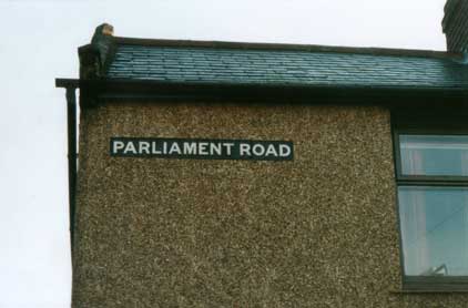
'Parliament Road' is a (presumably) cast iron sign
which must have been
fixed to the brickwork of the end-of-terrace on the corner with
Freehold
Road. The later pebbledash finish provides a snug frame for the
sign
which
the present owner (again presumably) keeps sharply painted (in
negative!)
to catch the eye. Other negative paint-jobs on Street nameplates can be found at Dog's Head Street and Vernon Street.
Upper Orwell Street
 2014
image
2014
image
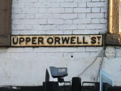
This cast iron street nameplate with its characteristic supetior
'T' has both angled clamps around the edge and three screw-hole drilled
above the characters to fix it to the brickwork above the café opposite
The Spread Eagle public house. There is an oval water hydrant medallion
as a bonus (see Street furniture
for an explanation). See our Spread Eagle
page for a view of round-the-corner in Eagle Street and the street
nameplates there.
Upper Orwell Courts
 2014 images
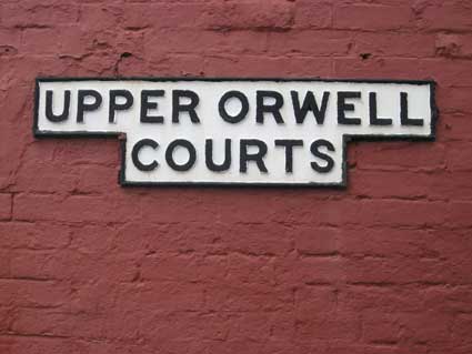
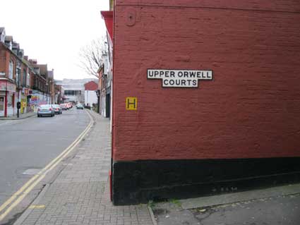
A street name redolent of times gone by. This small
lane
off 'The Wash' as
Upper Orwell and Lower Orwell Streets were once known, now runs up to
the
parallel
Bond Street: the only street to link the two above Eagle Street. Now
virtually
a mere footway, it is blessed with this impressive (and unusually
shaped)
thick, cast iron sign at The Wash end. Someone cares enough to maintain
the paintwork of the relief lettering; it contrasts strongly with the
neglect
of the similar vintage Bridge Street
sign.
We read with some interest that in a past century such was the flow of
water
down this way from Majors Corner, past Stepples Street towards the Wet
Dock,
that a man was prosecuted for erecting an illegal water wheel.
Cold Dunghills
Upper Orwell Courts was the site
of the 'Cold Dunghills'. 'In the 19th century it was quoted as
being a “filthy, dirty, foul slum, full of disease and undesirable
elements”. In 1861 it comprised some 20 tenements and 66 inhabitants,
and it remained the poorest part of Ipswich. In October 1867 the
residents petitioned to have the name changed and it became known as
Upper Orwell Court, the name it still retains today. The area was not
entirely cleared until just before 1939. No
reason is known why it was extra-parochial, but with
a name like this it could have been an original waste-land where the
town sewage was deposited. It was just the other side of the town
ramparts. In 1632 it is recorded as “Cole Dunghill”. ‘Cole’
is the
early English for ‘charcoal’, and waste-land was frequently utilised
for the making of charcoal. Charcoal and dung are both used for fuel
in many parts of the world today. Whichever way it is regarded,
‘waste-land’ was frequently extra-parochial because nobody wanted to go
there to collect taxes.' [Information from Planet Ipswich website,
see Links]
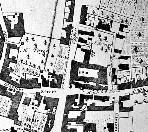
Below: a detail from Pennington's map of 1778 shows a much more open
townscape with trees and gardens around the buildings. Orwell Place has
its original name of Stepples Street to mark the stepping stones
('stepples') which were a feature to enable passers-by to cross the flowing waters of the Wash (Upper Orwell
Street). Eagle Street is here labelled as the west end of Rope Lane.
The future Waterworks Street disappearing southwards to include Angel
Lane is here labelled 'St Clements Back Street'. We can see a small
pound (so labelled) where stray livestock would be impounded and not
released until the owner paid a fine. The narrow lane running north
form the pound, then turning through 90 degrees to the east is, in
1778, clearly labelled 'Cold Dunghills'.
 1778
map
1778
map
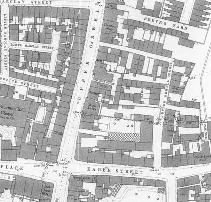
The 1881 map below shows a very different road
layout. Waterworks
Street appears at the lower right at the junction with Eagle Street.
The thoroughfare was later continued northwards to St Helens Street and
called Bond Street. It looks as if, given a bit of road widening, it
used the line of Upper Orwell Courts, which we now discover was 'L'
shaped. Five addresses up from The Spread Eagle at the crossroads, is
The Eagle Tavern, site of the Palmer's
Door Mats sign. Incidentally, The Bulls' Head public house is shown
at this date, on the south-west corner of the crossroads (across Fore
Street from The Spread Eagle),
later to become part of the Martin &
Newby shop.
 1881 map
Further up the Upper Orwell Street, on the west side is Union Street
down
which is the ancient trace of the sign for Charles
Court; see our 1880s map of the courts
and yards for an image.
Dove Yard
 2014 images
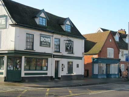
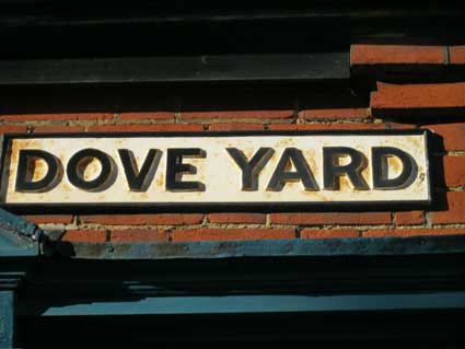
Above left: The Dove public house (in 2014 inexplicably entitled The
Dove Street Inn) on the corner of Dove Lane, to its right the former
Newstead's bakery shop and, now bricked up, the former Nippin café. All
these front St Helens Street. The
classic cast iron street sign: 'DOVE YARD' is seen above the entry by
the former shopfront, an echo of the 19th century Potteries area full
of Courts & yards. The clear, bold
sans serif capitals and surround are in deep relief against the white
background to enable clear readability.
 1930s?
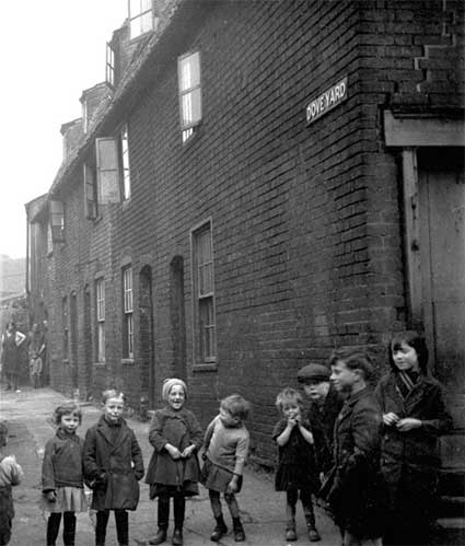
Above: Dove Yard as a rather bleak residential road in (possibly) the
1930s. Historian Frank Grace has pointed out that, when looking at old
photographs, one can judge the quality of the houses by the levels of
the wimdows; if the line of the window sills is even, the builders took
care – if the sills and tops are at varying levels, the houses were
hastily built. In the above image, the housing is clearly of poor
quality, probably late Victorian in vintage, matching many of the
residential buildings (often slums) in the adjacent Potteries area of Ipswich at that time.
The cast iron street nameplate at the top right may very well be one
which survives today – in this case painted in 'negative' (characters
white, background black); see also Parliament Road above.
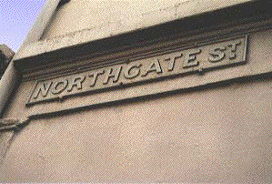
Northgate Street

The familiar cast iron style street sign can be seen opposite The
Halberd Inn: 'NORTHGATE ST.'
 2004
2004 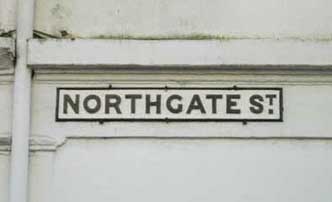 2014
image
2014
image
Above left:
Here the studs fixing the sign to the rendered
brickwork are clearly visible,
as is the fact that the Alexandra Hair Designs salon has covered the
whole
thing in their beige masonry paint! (Ten years later, order has been
restored
and a signwriter has picked out the characters and frame in black.) The
superior 'T' above a
full stop in
'ST.'
marks this street sign out as a partner to the now extinct Bridge
Street near Stoke Bridge and the Lower
Brook
Street sign. Before metal street and road signs, the names were
sometimes painted onto brickwork; see Lancaster
Road for some vestiges. See our Ipswich
Transport Museum page for some rescued examples of street name
plates.
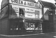 Just for interest's
sake,
here's a period image of that 'Northgate St.' wall, when the street
sign was sited near the pavement: a riot of drop-shadow capitals -
probably in
two colours against a tinted cream-washed rendered wall:
Just for interest's
sake,
here's a period image of that 'Northgate St.' wall, when the street
sign was sited near the pavement: a riot of drop-shadow capitals -
probably in
two colours against a tinted cream-washed rendered wall:
'GREEN & HATFIELD
ANTIQUES [vertical]
LARGE
SHOW
ROOMS
THE OLD
CURIOSITY
SHOP'
Green & Hatfield's 'Old Curiosity Shop' on the
corner of Northgate Street and St Margaret's
Street (a squib of a
street running unnoticed from St Helen's Street at Major's Corner and
into Crown Street) was once a well-known landmark of Ipswich. You can see the shelves of antiquarian books through the
front window – as you used to be able to do in the window of the
collector's shop 'Atfield & Daughter' (the wonderful building The
Sun Inn) in St Stephen's Lane. Mr Green retired from the business and
in the early 1980s was still living in the large house built in 1850
(it had it's own chaise house in the large garden, which still stands
today) which stand on the corner of Belle Vue Road and Woodbridge Road
between Russell Villas and Shaftesury
Villas.
South Street
 2017 images
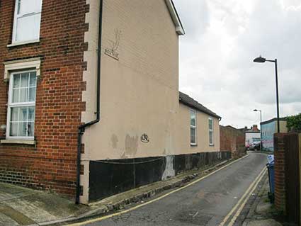
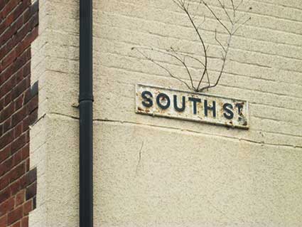
Two small points strike one from the overall view at the left: (a) the
kerb along the length of the house is composed of granite setts; (b)
one has to admire tenacious Nature for finding a way for a weed to seed
itself above the street nameplate.
There's not a lot in South Street these days: on one side the back
gardens of the houses in Ann Street and on the other a car park.
However, the 1902 map detail (below) show it full of houses on the
south side of South Street, so it wasn't merely a back lane for the Ann
Street houses. In 2020 the only address in the street you might come
across is the South Street Studios, a community music and performance
organisation at the eastern end.
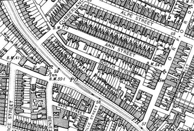 1902 map
Related pages:
Street
nameplates; Street nameplates on posts;
Examples of Street
nameplates (Parliament Road etc.);
House
name plaque examples: Alston
Road;
Bramford
Road;
Cauldwell
Hall Road; Cavendish
Street; Marlborough
Road; Rosehill
area; Belle Vue Road
Ipswich
& Suffolk Freehold Land
Society (F.L.S.); California
Street
index; Streets
named after slavery
abolitionists;
Dated
buildings list; Dated
buildings examples;
Named
buildings list;
Named
(& sometimes dated) buildings
examples.
Brickyards;
Ropewalks
Home
Please email any comments
and contributions by clicking here.
Search Ipswich
Historic Lettering
©2004 Copyright
throughout the Ipswich
Historic Lettering site: Borin Van Loon
No reproduction of text or images without express written permission