The Wet Dock
The very
heart of
the ancient town was the natural
right-angle bend in
the
river and its sudden narrowing down towards the site of the present
Stoke
Bridge (the confluence of the fresh water River Gipping
and the
brackish
River Orwell takes place, not here – contrary to popular belief – but
further inland above Handford Bridge). The earliest crossing point of
this broad and
sweeping
waterway,
so central to the establishment and development of Ipswich as an
international
port, would originally have been a ford between the site of
Great Whip
Street
and the present St Peters Dock at Foundry Lane. The fact that it could
be forded at
all,
shows how marshy parts of early Ipswich were, the nineteenth
century
Wet Dock coming to a deep-channelled 'nip' near this point, bordered by
the heavy industrial quaysides we know today.
The enormous structures in brick and
concrete which largely replaced
the
timber-framed buildings erected by Tudor merchants were in turn
demolished and tower blocks built (see Waterfront
Regeneration Scheme) – until the money ran out in
2007/8.
However, there are
some
survivors: The Neptune Inn building
fronting Fore Street once had a
string
of structures behind it reaching the quayside. The Isaac Lord
merchant's
house with a similar frontage nearby in Fore Street uniquely retains
its saleroom, warehouse,
maltings
and stables, so that the corn exports and coal imports could be loaded
and
unloaded, processed and carted away under the eye of the owner. Here is
the earliest house in Ipswich, c.1480 (although Pykenham's
Gatehouse
beats
it by a few years and St Mary Elms has an ancient cottage (variously
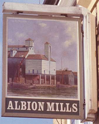
1467 or 1487) behind it. Ironically, the pub sign from near Parade Field Terrace (shown at the right)
depicts,
not the windmills which used to stand on Albion Hill to the east of the
town, but Cranfield's Flour Mill on the Wet Dock's Albion Wharf.
The signwriters have, over the years, worked to proclaim the company
names
on the frontages of the wharves overlooking the sweep of water formed
by
the magnificent Wet Dock which was opened in January, 1842 and at 33
acres
was the largest area of water of its kind in England.
Nowadays it's hard to see the water for leisure craft moorings.
The Big
Query art installation, University
of Suffolk
Christies
warehouse, Maritime Ipswich 1982 plaque
Bridge
Street, nameplate
Burtons, (also the history of Burton
Son & Sanders),
R.&W. Paul maltings (also a page about Paul's malting) –
also one on
Princes Street, The Bull Tavern
College Street
and its two beknighted buildings at risk (both lettered)
Coprolite
Street, the former electricity sub-station (now a restaurant, Duke
Street) and the nearby Grimwade Memorial Hall
Cranfield's
Flour Mill recalled on a printed sack
Custom House: which people call
'The Old Custom
House'
Trinity
House buoy
plus the Paul and Burtons structures on St Peter's Wharf (also a page about Paul's
malting)
Edward
Fison Ltd,
Bolenda
Engineering Ltd, 'London
Underground', Stoke Bridge Maltings
Ground-level dockside furniture
on:
'The
island',
the northern quays
and
Ransome's
Orwell Works
Ipswich
Whaling Station? No,
Halifax Mill
Isaac Lord, The Old
Neptune Inn (also a page on the Neptune Inn
clock, garden
and interior) plus the
frosted 'E. J. Owles Chemist' door and a map of the original Salt
Office
Isaac
Lord 2, within the complex: the crossway, saleroom and yard pump
The Island,
Public Warehouse, cranes and lock
John Good and Sons
– the story of a building
Maritime Ipswich '82 commemorated in
a series of images of the festival in and around the Wet Dock
Merchant
seamen's memorial on Orwell Quay
The Mill: the most recent addition to Ipswich's skyline
Nova Scotia
House: home of Richard Hall Gower; outside the Wet Dock, but
contains information about Ipswich shipyards
New Cut East,
Harbour Master's Office and Lock-keeper's Cottage
Quay
nameplates: in January 2021, a set of new blue namplates
appeared, thanks to IMT and the Borough, to celebrate old dockside names
Ransomes: the
surviving Electric Lorry Garage and even better lettered warehouse on
Cliff Road
Steam
Packet Hotel in Duke Street and '1620' shop at 32 Fore Street
Stoke
Bridge(s): one of
the most important historical places in Ipswich (and the whole country)
Waterfront
Regeneration Scheme 2005 to the financial collapse in 2007/8
Wolsey's
Gate on College Street; the rise and rapid fall of Wolsey's
College
A chance to
compare
Wet Dock 1970s with 2004
A
diagrammatic map of the Wet Dock
giving the
wharves and quays; also maps from 1804 and 1930
Davy's
illustration of the laying of the Wet Dock lock foundation stone,
1839
Outside
the Wet Dock...
A period view of Willam Brown's timber wharf on the dock can
be found on our JBO lost signs page.
Related pages:
Fore Street 1620 building; The Social Settlement.
House
name plaque examples: Alston Road;
Bramford Road;
Cauldwell Hall Road; Cavendish Street; Marlborough Road; Rosehill area;
Ipswich & Suffolk Freehold Land
Society (F.L.S.); California;
Street
index; Origins
of street names
in Ipswich; Streets named after slavery
abolitionists;
Dated buildings list; Dated buildings examples; Dated rainhoppers and weather vanes
Named
buildings list; Named (&
sometimes dated) buildings
examples;
Street nameplate examples; Boundary
markers
Ipswich
Tomorrow, Greyfriars 1960s
Rampart and Town gates
Historic maps of Ipswich
Timeline: historical eras, events and
monarchs
Monasteries
Blue plaques
Ipswich coat of arms
Pubs & Off licences
Brickyards; Ropewalks in Ipswich
Water in Ipswich
Listed buildings in
Ipswich
Windmills
in the Borough of Ipswich
[Our background letter 'O' is taken from the John
Good & Sons
building – the sign now obliterated.]
Home
Please email any comments and contributions by clicking here.
Search Ipswich
Historic Lettering
©2004 Copyright
throughout the Ipswich
Historic Lettering site: Borin Van Loon
No reproduction of text or images without express written permission