Plough Street:
smallest street in Ipswich
A big claim, but Plough Street off Fore Hamlet wipes out
competition
from Pleasant Row (off Smart
Street).
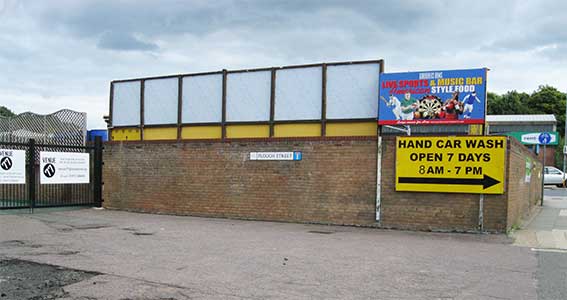
Running beside the Gardeners Arms public house, the line of
Plough Street is, in 2017, bordered by Venue 77, a music venue attached
to the pub.
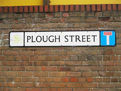
The Borough clearly decided that this thoroughfare, all ten
yards or so of it (and having no residences or businesses fronting it),
deserved its own street nameplate. Quite touching, really. The
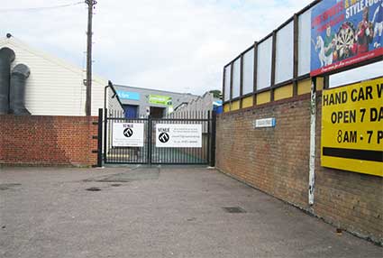
line of the old street carries on past the gates with industrial units
behind. See the update
below.
The 1902 map of the area shows a somewhat longer street here,
with its cul-de-sac close to the kilns of 'Trinity Brick Works'.
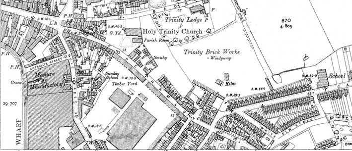 1902
map
Perhaps Plough Street was named after one of the most numerous
products of the Ransomes Sims & Jefferies
engineering works nearby? Perhaps a bit speculative for our Street name derivations list.
The detail below shows the italic 'P.H.' (shown in blue) for the
public house with a
wide yard (still in evidence today – see the above photographs)
funneling down to the narrow Plough Street and lined, in 1902, on
either side by small terraced cottages with rear yards and perhaps
workshops at the far end to the east. The cottages
fronting Fore Hamlet to the west of the public house (shown in red)
have today gone
and the land is given over to the car park. The narrow terraced
cottages, six in number and fronting Fore Hamlet and between Plough
Street and Cavendish Street (shown in green), have gone making wider
jaws of
Cavendish Street for modern vehicle access. Densities of working class
housing in 1902 are, as ever, striking.
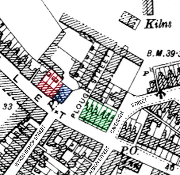 1902
detail
The Gardeners Arms (from
the Suffolk CAMRA website):
'The fact that this pub is listed from 1881 as the "New Gardeners Arms"
suggests that the building dates from about that time, replacing a
different building of the same name located somewhere nearby (probably
on the other side of road), which closed in 1880. It was also still
known as the New Gardeners Arms as late as 1928. It closed as the
Gardeners Arms in 1994, when the building became an off-license
warehouse. In the 1970s it had a reputation as a bikers' pub. In the
mid 1990s, after closure, it was used as an off-licence warehouse for
several years and was called Mr Wines & Beers. Sadly, the original
bar counter & back bar were sold off and are now fitted in an
American bar. Listed at 75 Fore Hamlet by 1888.' Today's Gardeners Arms
frontage is 'L'-shaped with further building to the rear and it seems
likely that this frontage dates from the 1920s/1930s, replacing the
more rectangular pub building shown on the map.
Other features noted from the 1902 map: across Fore Hamlet from Plough
Street we see the northern ends of Wykes
Bishop Street and Albion Street (both having extant road signs).
Both have been closed off and the modern building housing 'The Orwell
Centre: home of the Hope Church' marks the position of the two roads
where the vehicle entrances are at each end. Myrtle Road (not shown here) slightly
to the east still exists and marks the change from Fore Hamlet to Bishops Hill. The 'Inn' labelled on the
map on the south of Fore Hamlet (next to a Post Office) is the Myrtle
Inn, formerly the Blooming Myrtle Tavern (closed 1936) which gave its
name to Myrtle Road. Apparently there was once a 'Myrtle Tap' on
Bishops Hill.
[UPDATE December 2019: the tiny
piece of Ipswich history that was Plough Street has sadly disappeared
as the owner of the Gardeners Arms public house has extended his land
in front of Venue 77 and the street nameplate has now joined our These we have lost page.]
See also our Street nameplates
page.
Home
Please email any comments
and contributions by clicking here.
Search Ipswich
Historic Lettering
©2004 Copyright
throughout the Ipswich
Historic Lettering site: Borin Van Loon
No reproduction of text or images without express
written permission


 1902
map
 1902
detail