Numbering the bridges
The original road bridges carrying
traffic accross
the Great Eastern
Railway's Ipswich - Westerfield - Felixstowe line, the latter part
built by Colonel
Tomline
(after whom a road between Foxhall Road and Derby Road in the Rosehill
area is named) are
numbered consecutively. This line opened
in 1877 with its wondrously lofty viaduct where the line suddenly
leaves
the cuttings (as shown in some of the photographs), leaps the deep
valley of
Spring
Road and plunges back into a cutting leading to the Wellesley Road
bridge. Quite why every bridge has been
carefully numbered in white stencilled figures against a black panel is
of interest. Presumably gangers arriving to access the trackside were
directed
to the nearest numbered bridge to avoid confusion [see updates below].
 (a)
(a) 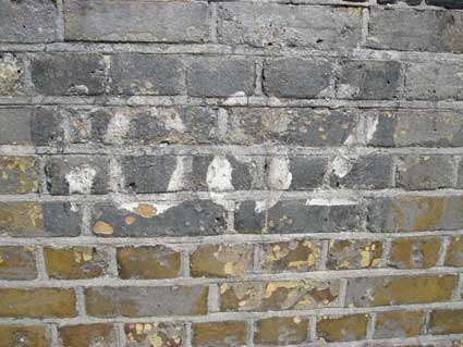 2012 images
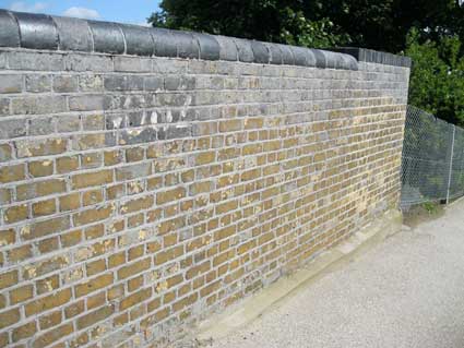
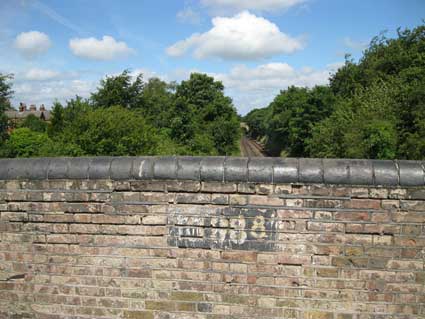
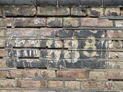
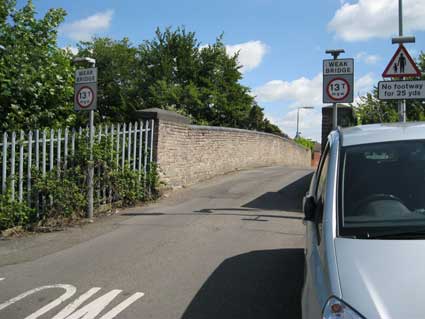
(a) The first
bridge (1082) after Westerfield
junction:
Tuddenham Road.
Incidentally,
for information on the light railway which
ran
from Westerfield Junction down into the Grove and Dales brickyards, see
our Brickworks and Ipswich's forgotten railway pages.
[UPDATE 12.10.2012: "In your
web site article about railway bridges – you are correct in your
assumption.
All railway bridges are numbered as
part of the method of location
identification. However, where your information goes wrong is that this
information was used by ALL railway staff whose duties involved use of
that bridge. Also, signallers would use such information to advise
Drivers of a location to which a caution was to be observed.
I can remember the many drivers who
all knew of tales about bridge
numbering and peculiarities attached to a bridge. Those Train Drivers
would often know the name of the road, farm or property with which the
bridge was attached.
Bridge numbers were numbered
according to the line they were on –
so those going to Felixstowe would have used a different sequence to
those used on the London- Norwich line.
Hope this helps, Andrew Brown
(worked on the Footplate for the better
part of 30 years)". Many
thanks to Andrew for the authoritative clarification.]
[UPDATE 29.10.2012: "Hi Borin,
Just picked up your very interesting web site from Ipswich Society
article. You’re quite right, all railway structures are
given an identification number. On the London to Norwich line the
numbering starts at Liverpool Street station; the distance from
this
source is also often denoted in miles and chains! By this means,
accurate location of any part of the railway system can be described,
but I expect you may have heard this already. Keep up the good
work. Best wishes, Tony Hill"]
(b)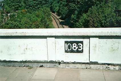 (c)
(c)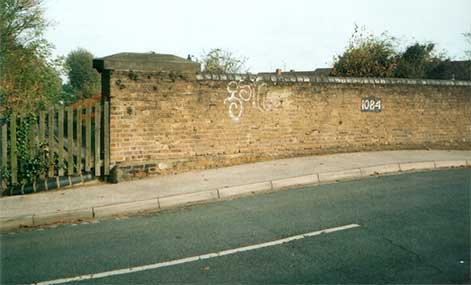
The picture (b) is
taken
from Colchester Road, close to the end of
Cemetery Lane (risking very
heavy
traffic!), the white-paint of the concrete bridge carefully avoiding
the black panel and number (1083).
Number
1084 (c) is the bridge in Belvedere
Road just before
it goes through the old cemeteries.
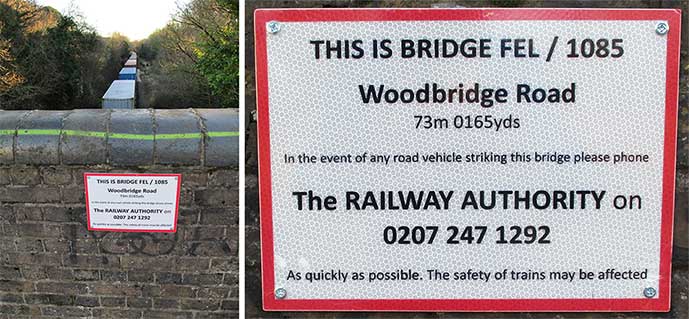
(d)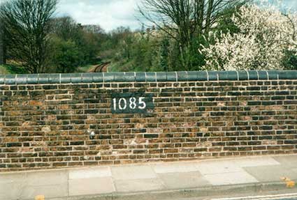 Most
numbers seem to be painted on
the wall of the bridge on the Westerfield Junction side of the
line. (d) is
a picture of the Woodbridge Road
bridge
(1085) which lies close to the
end of Belle
Vue
Road. [UPDATE 13.11.2023:
due to a crack in this western parapet of the bridge carrying
Woodbridge Road over the railway, a major renovation using the original
Victorian bricks took nearly six weeks to complete. This arterial road
was closed for the first weekend in October and large protective
concrete block barriers installed. Scaffolding was erected on the
railway side of the bridge.The photographs show a view during
demolition with the saved bricks lined up; the large heavy capstones
were later removed, presumably with the use of a crane. These capstones
were the last to be replaced overnight on 11.11.2023.]
Most
numbers seem to be painted on
the wall of the bridge on the Westerfield Junction side of the
line. (d) is
a picture of the Woodbridge Road
bridge
(1085) which lies close to the
end of Belle
Vue
Road. [UPDATE 13.11.2023:
due to a crack in this western parapet of the bridge carrying
Woodbridge Road over the railway, a major renovation using the original
Victorian bricks took nearly six weeks to complete. This arterial road
was closed for the first weekend in October and large protective
concrete block barriers installed. Scaffolding was erected on the
railway side of the bridge.The photographs show a view during
demolition with the saved bricks lined up; the large heavy capstones
were later removed, presumably with the use of a crane. These capstones
were the last to be replaced overnight on 11.11.2023.]
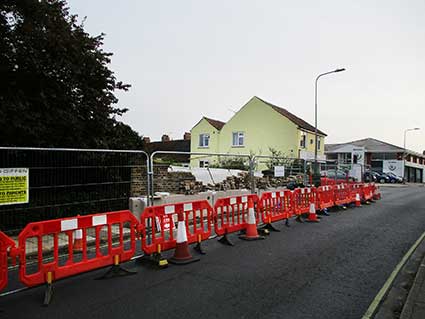
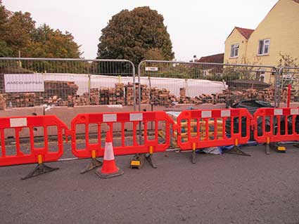 2023 images
Below: the completed parapet with original bricks, but minus the
painted number 1085. One or two of the reused bricks sem to bear some
of the original dark grey surround. By January 2024 the rather
workaday panels givng the bridge number have been screwed to both
parapets. Looking east towards Derby Road Station, we see that the
plastic sign has been screwed over sprayed grafitti; a container
freight train is halted in the cutting.
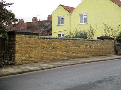
 2024 images
The bridge at Wellesley
Road (not
shown) leading
into Marlborough
Road
near Clifford Road School has been
rebuilt and does not bear its number (1086).
(g)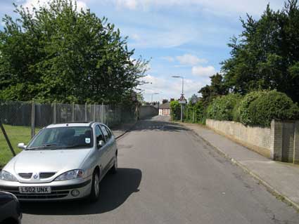
 2012 images
(g) is the tiny bridge (1088)
carrying Fuchsia
Lane. Firstly
from the Cauldwell Hall Road end (stencilled
twice)...
... then from the Foxhall Road end.
(h)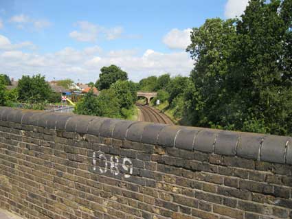
(h) is the Foxhall
Road bridge (1089) with
the Fuchsia Lane
bridge in the background.
(j)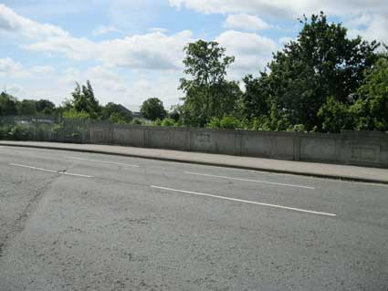
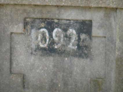
(j) is the concrete bridge (1092) carrying Felixstowe Road
over the line,
close to the St Augustine's roundabout.
(k)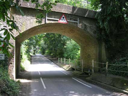
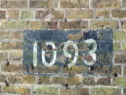
(k) Just to prove our dedication to the task, this
one carries the railway over the lane
down to Nacton village from the
old Felixstowe Road – and yes, it's numbered: 1093.
The bridge in Derby Road next to the station was
rebuilt to
a higher specification to enable larger container trains through
(similarly,
the Stoke Bridge tunnel had its trackbed lowered in 2004), so the
number
has been lost. The building of the tunnel by Peter Bruff for the Eastern
Union Railway,
whose line originally terminated at the site of the original station
and
marshalling yard near Station Street, Croft Street and Little Station
Street
(off Wherstead Road) opened up the routes to Stowmarket, Bury St
Edmunds,
Peterborough, Norwich, Lowestoft and Felixstowe. The line to Felixstowe
transformed the small fishing village on the North Sea coast at the
mouth
of the Orwell and Stour rivers (population from the 1861 census: 673
persons)
into a successful seaside resort and later into a major port which
today
threatens to swallow up ever greater stretches of the natural
riverbanks
towards Trimley.
Colonel George Tomline, a Suffolk landowner who
lived at Orwell Park on the edge of Nacton village (now a public
school), promoted the
Felixstowe Railway
and Pier Company in a parliamentary Bill of July 1875. (see also Street name derivations for Tomline Road.)
With impressive
speed the line was built and the first train ran on 1 May 1877. A
further Act of Parliament in July 1879 enabled the building of a dock,
approach channels and additional railway lines to the dock area.
Once the new Ipswich Station was established at its
present site in
Ranelagh
Road/Burrell Road the engineers had to navigate a route around the
majority
of a large, well established town to reach Felixstowe. Striking out
westward
(in the opposite direction to Felixstowe), the line travels out in a
wide
curve which continues past the main junction to Norwich, between London
Road/Crane Hill and Hadleigh Road (close to sites of mileposts), then over Bramford Road and
Norwich Road (site of
the
famous Ferodo sign!). Then under
Dale Hall Lane and Henley Road. Leaving the edges of Castle Hill the
line
is now heading north-east towards Lowestoft until it reaches the level
crossing
at Westerfield. The original station building - now a residence - is
tucked
away behind the present station. Westerfield junction, several miles
outside
the Ipswich, is the chance for the line to leave the Lowestoft branch
to
whiplash
back towards north and east Ipswich
(apparently
Ipswich Corporation forbade Colonel Tomline from building a railway
through any central part of the busy town). The
bridges are listed in sequence below with the confirmed numbers:-
(a) Tuddenham Road; 1082
(b) Colchester Road: 1083
(c) Belvedere Road: 1084
(d) Woodbridge Road: 1085
(e) Spring Road viaduct (1086)
(f) Wellesley Road: refurbished; no number visible (1087)
(g) Fuchsia Lane: 1088
(h) Foxhall Road: 1089
(i) Derby Road (replacement structure - presumably 1090); 1091 missing: a mystery [Note: at this point the line is
only one and three-eighths of a mile from the London to Norwich line as
it passes the old Stoke sidings (now housing); click
to view a map of Ipswich from c.1930 which
shows the
pattern of Ipswich railways (and more).]
(j) Felixstowe Road: 1092
Modern bridges over recently cut-through roads: Ransomes Way (near
Warren Heath
Sainsbury) and A14 (both unnumbered). The line for a considerable
distance from St Augustine's runs parallel and close to the road.
(k) Rail bridge over lane down to Nacton village from the old
Felixstowe Road: 1093 [This was the site of the Orwell Station; in
fact, the Station Master's house still stands close to the bridge.]
From there it is finally on its West-sou'-west course to
Trimley
and Felixstowe. What a curious journey it
is.
[UPDATE 1.3.2017: see
our page on the Ipswich-Westerfield-Felixstowe
Branch Line, with
excellent period photographs of all the stations by Richard Casserley
and his father,
Henry.]
Reading: Cobb, S.: Ipswich to
Felixstowe: 125 years on the line (see Reading
list).
See our Princes Street
page for the Princes Street bridge (over the River Gipping) plaque
replacing one originally erected erected by the railway company. See
also our Bourne Park page for the numbered bridges carrying the main line over the
approach to the park; also the EUR/Croft Street
page for further information on the main line, station and
Stoke tunnel.
[UPDATE 28.6.2012:
"Excellent photos, Borin! Actually, I spent a good half hour (and
counting), just looking at other parts of your web site last last week.
Really interesting! I had always wondered who Bishops Hill was named
after (and actually contacted the council a few years ago - they did
not
know).
It is rumoured that Tomline - who hated the Cobbold family - built the
Felixstowe Stations so that they were
sited well away from the Ordnance
Hotel owned by John C Cobbold!
Were there no numbered bridges after Nacton - or does your remit not
stretch further than that?? From Tina Hammond" We ran out of steam near Amberfield
School, but are sure that the numbers continue.]
Bramford
Lane, Bramford Road bridges
 2014 images
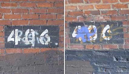
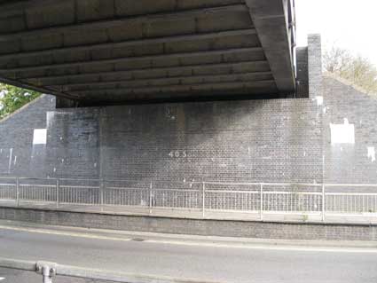
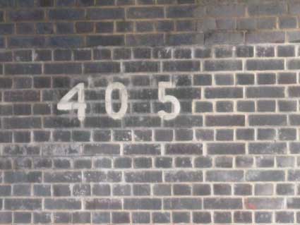
The Ipswich to Lowestoft and Felixstowe line (splitting at Westerfield
Junction) crosses Bramford Lane
at the 'nipped in' arched bridge which
has its number '406' stencilled
on each side of the interior. Meanwhile
its near neighbour in Bramford Road
has '405' clearly marked on
the northern inner wall.
Wherstead Road bridge(s)
Bridge No. 248: we believe that
the dip in the road here was to accommodate the clearance required by
tramcars, which were introduced after the rail line was constructed.
This bridge features a passenger underpass to the right. The steel bridge carrying
the Griffin Wharf branch over Wherstead
Road is apparently unnumbered.
However, on examination of the white signs on each side, we find that
it is numbered '248' – which doesn't exactly fit in with 244 and 243
further south.
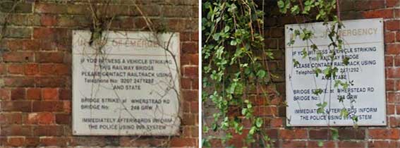
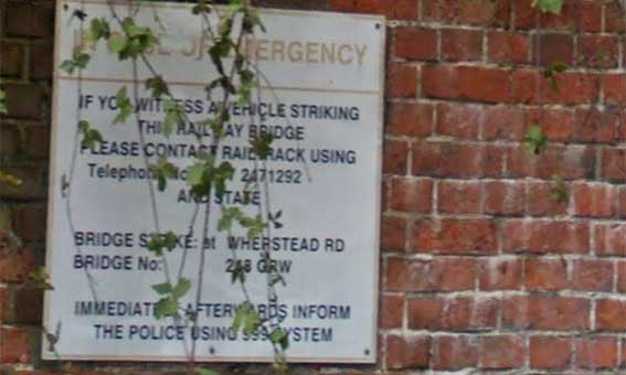
'IF YOU
WITNESS A VEHICLE STRIKING
THIS RAILWAY BRIDGE
PLEASE CONTACT RAILTRACK* USING
Telephone No. 0207 2471292
AND STATE
BRIDGE STRIKE: at
WHERSTEAD RD
BRIDGE NO. 248 GRW
IMMEDIATELY AFTERWARDS
INFORM
THE POLICE USING 999 SYSTEM'
*Footnote: Railtrack was a group of companies which owned
the track, signalling, tunnels, bridges, level crossings and all but a
handful of the stations of the British railway system from 1994 until
2002. It was created as part of the privatisation of British Rail under
Prime Minister John Major. In 2002, after experiencing major financial
difficulty, most of Railtrack's operations were transferred to the
state-controlled non-profit company Network Rail.

 2016 images
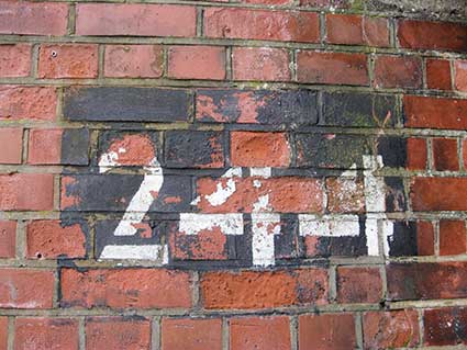
Bridge No. 244. A narrow
asphalt path runs away from the main road (directly opposite no. 501 Wherstead Road –
with the red front door at the centre of the above left photograph). It
passes one or two dwellings, then slots underneath the main railway
line to meet a couple of undistinguished footpaths. It's such a modest
bridge, it really looks like the sort of crossing you would see on a
single-track branch line. Stand beside it for a while and you know
different.
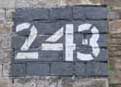 Bridge
No. 243: see our Bourne Park page.
Bridge
No. 243: see our Bourne Park page.
Eastern Counties signals &
regulations book 1846
; this link takes you to a weg-page for a download of all the
pages in the 1846 railway booklet.
Home
Please email any comments and contributions by clicking here.
Search Ipswich
Historic Lettering
©2004 Copyright
throughout the Ipswich
Historic Lettering site: Borin Van Loon
No reproduction of text or images without express written permission