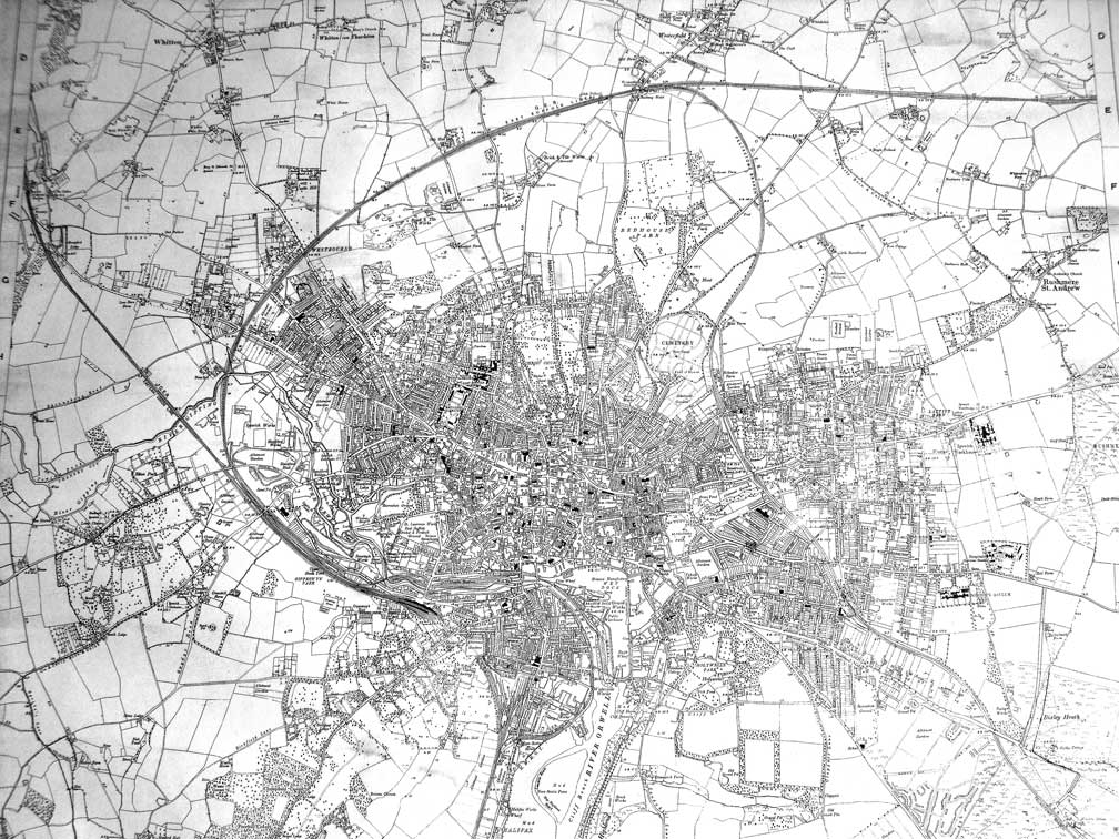
Map of
Ipswich: c.1930

This
clearly shows the shapes of the railways
around Ipswich in 1930.
Our thanks to Gordon Pugh for sending in a shot of this map:
"We think it dates back to around 1930. Clue: there is no Lloyds Avenue
or Arch, the railway track in the Dales brick works among many other
things we found."
Gordon is particularly interested in the rail bridge which carried a
spur line over Ranelagh Road, east of the mainline station platforms,
into Reavell & Co. Ltd foundry site (later to become
Compair-Reavell and these days the Voyage housing/small business
development and tower block, linked to West End Road by the new
footbridge). It was a little further east of the spur which crosses
Ranelagh Road on the level crossing which we still see today (although
fenced on each side) and provided a line over the river, ran beside the
confluence of the Gipping and Orwell rivers, beneath Princes Street,
serving sidings (marked 'Goods Station', now the site of the Skate
Park), crossing Bridge
Street, encircling the Wet
Dock via the lock and eventually
running down to serve the Cliff Quay Power Station. The Reavell's site
is marked 'Ranelagh Works' and the rail line runs over a bridge across
Ranelagh Road, through the works to
terminate near to the river bank. If anyone can remember this bridge,
the line or when it was demolished, please email
us.
Although 1930 sounds like relatively recent history this map reveals a
very different Ipswich:
- before by-passes (e.g. Yarmouth Road/Valley
Road/Colchester Road) so the main roads in the town are radial from the
centre,
- before housing developments (notably The
Dales:
the whole area, up to
and including The Grove off Henley Road, being a brick and tile works
–mentioned by Gordon – with its own long rail spur
which crossed back over Henley Road and Dale Hall Lane: disused by this
time, see the Brickyards page for more
on this),
- the 'Towing Path' on the River Gipping is
labelled bigger and clearer
than many main street names,
- the Wet Dock 'island' which still owes its
shape
to the earlier side
lock in New Cut East (the old entrance in the quayside, opposite The
Steamboat Tavern) and a 'Branch Dock' cutting horizontally into the
middle of the triangle, its mouth opposite Ransome's Wharf –
our Wet
Dock map gives more information
on this
area,
- the 'Bathing Place' is clearly marked below
Griffin Wharf – today this
lies under the West Bank container terminal; another 'Bathing Place' is
marked on the Gipping close to the Constantine
Road power station,
- the 'East Suffolk Cricket & Footbal
Ground'
(note the order of
the sports) lies between Constantine Road and 'Portman's Road', close
to Churchman's 'Tobacco Manufactory',
- the 'Hospital (Infectious diseases)' on
Foxhall
Road (see the Museum
exhibits page
for the sign-board), over the road from the 'Borough Asylum' (St
Clement's Hospital),
- the present-day Garland public house on
Humber
Doucy Lane at Rushmere is
labelled 'Greyhound Inn'.
See also our page on the Ipswich-Westerfield-Felixstowe
Branch Line, the Ipswich parts of which show clearly on this map.
This map forms the basis of the Freehold Land
Society map of developments created by Borin Van Loon for the
Ipswich Buidling Society's new branch at Mutual House.
Home
Please email any comments
and contributions by clicking here.
Search Ipswich
Historic Lettering
©2004
Copyright
throughout the Ipswich
Historic Lettering site: Borin Van Loon
No reproduction of text or images without express written permission
