691 Woodbridge Road
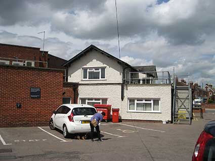
Paul S. Smith writes: 'Since I've come across your website I tend to notice a bit more when driving about... Barclays Bank on corner of Woodbridge Rd & Rushmere Rd. White building to rear has date on gable. Viewed from Woodbridge Rd.' (Thanks for the tip-off, Paul; also for that about the Bramford Lane Co-op monograms.)
And how right he is:
 2016 images
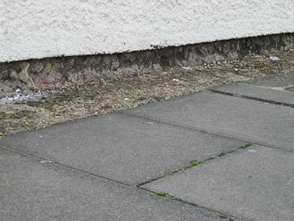
The car park to the rear is a bit of a mish-mash.
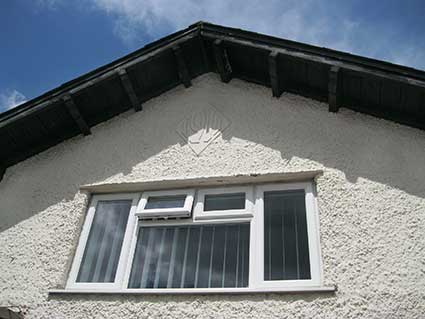
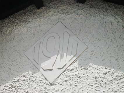
In the apex of the gable is a rather nice figuring of '1911' in a square (turned on its point). It is interesting to contrast this with large dated house panels in Roundwood Road ('1926') and on Nacton Road ('1901') shown on the same page.
The Turnpike Toll-house
And while we're hereabouts, let's recall the original use for this building. Continue across the car park to the wall facing the jaws of Roundwood Road, (on the other side of Rushmere Road). Close inspection of the small section of walling not covered with roughcast rendering reveals, near ground level, a change from red brickwork to flint construction.
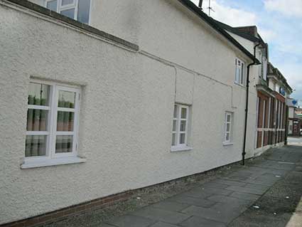
The flint section is the original toll-house, erected by The Ipswich To South Town (Yarmouth) & Bungay Turnpike Trust, which was inaugurated on Friday 20 May 1785, to collect tolls from travellers at this junction of Woodbridge Road and Rushmere Road. However, up to the late-18th century, the former did not exist as such, the whole area would have been meadows and countryside. On leaving the town centre in their carts and carriages, travellers often avoided the area in St Helens Street – at the junction with 'the old hollow Way into Ipswich' (Spring Road) – which was often impassable to vehicles as it was usually waterlogged and flooded regularly in heavy rain, as dealt with on our Water in Ipswich page. They travelled instead via Rushmere Lane, otherwise the 'Way to Woodbridge', as it is shown in early maps of the roads radiating out to the east, i.e today's Woodbridge Road. Rushmere Lane led up to the site of the 'Barclays toll-house" and followed the course of today's Rushmere Road, becoming Thomas's Way and leading only to the village of Rushmere St Andrew.
There was a rather more roundabout way to Woodbridge than we are used to today. The horses having made the haul up the hills out of Ipswich, the second being Albion Hill, they then reached the start of Rushmere Road (as it remains today) and turned sharp right, southwards down 'the Old Road', which would have run between the lines of today's Cauldwell Hall Road and Kirby Street. At a site not far from today's Spring Road/Cauldwell Hall crossroads, there was 'the old hollow Way into Ipswich' to the right (no more than a footpath downhill through woods and meadows to eventually follow the Cauldwell Brook towards the town) and 'the Old Road' to the left. This is today's higher level stretch of Spring Road which ran as far as The Lattice Barn (now disappeared), which stood to the south of the road and gave its name to the public house over the road.
The Turnpike Trust presented a plan to build a straight road through farmers' fields from the "Barclays toll-house" to The Lattice Barn. There was clearly another Toll Gate further eastwards along the road which today we call Woodbridge Road East; it was situated more-or-less where the petrol station stands today. This would have been the main Toll Gate and the person who managed this would probably have also managed the Side Gate at Barclays junction. This straight, and much more direct, section of road was duly built and, in the years to come would act as the northern border road of the California estate from which the Freehold Land Society hung the gridiron-style roads of Kirby, Milton and Howard Streets and Britannia Road.
However, people were very ingenious in trying to avoid paying tolls to the Trust to finance decent roads. Travellers towards the town centre would detour off Woodbridge Road to the right up Humber Doucy Lane. Probably travelling mainly on cart-tracks and looping over the north-east part of the environs of Ipswich and the parish of Rushmere St Andrew, they would eventually drop southwards to meet the main road into Ipswich, avoiding the Side Gate at today's Barclays Bank. In 1820 the Turnpike Trust built a second Side Gate at this junction (a couple of hundred yards to the west) to collect tolls. The cart track eventually became known as Sidegate Lane. The Barclays Side Gate seems to have come into the ownership of Captain W.F. Schreiber, owner of The Roundwood (as shown on our Roundwood Road page) in the 1840s. The toll-house became the home of his gardener, presumably after the Turnpike Trust was wound up in 1872.
[Includes information from Sexton, L.: Fifty four miles to Yarmouth (see Reading list) and Hillary Platts' research into California and the FLS.]
See our Street name derivations page for Nelson Road, Roundwood Road and Schreiber Road.
See also our Milestones page for more on the turnpikes.
Home
Please email any comments and contributions by clicking here.
Search Ipswich
Historic Lettering
©2004 Copyright throughout the Ipswich Historic Lettering site: Borin Van Loon
No reproduction of text or images without express written permission
Paul S. Smith writes: 'Since I've come across your website I tend to notice a bit more when driving about... Barclays Bank on corner of Woodbridge Rd & Rushmere Rd. White building to rear has date on gable. Viewed from Woodbridge Rd.' (Thanks for the tip-off, Paul; also for that about the Bramford Lane Co-op monograms.)
And how right he is:
2016 imagesThe car park to the rear is a bit of a mish-mash.
In the apex of the gable is a rather nice figuring of '1911' in a square (turned on its point). It is interesting to contrast this with large dated house panels in Roundwood Road ('1926') and on Nacton Road ('1901') shown on the same page.
The Turnpike Toll-house
And while we're hereabouts, let's recall the original use for this building. Continue across the car park to the wall facing the jaws of Roundwood Road, (on the other side of Rushmere Road). Close inspection of the small section of walling not covered with roughcast rendering reveals, near ground level, a change from red brickwork to flint construction.
The flint section is the original toll-house, erected by The Ipswich To South Town (Yarmouth) & Bungay Turnpike Trust, which was inaugurated on Friday 20 May 1785, to collect tolls from travellers at this junction of Woodbridge Road and Rushmere Road. However, up to the late-18th century, the former did not exist as such, the whole area would have been meadows and countryside. On leaving the town centre in their carts and carriages, travellers often avoided the area in St Helens Street – at the junction with 'the old hollow Way into Ipswich' (Spring Road) – which was often impassable to vehicles as it was usually waterlogged and flooded regularly in heavy rain, as dealt with on our Water in Ipswich page. They travelled instead via Rushmere Lane, otherwise the 'Way to Woodbridge', as it is shown in early maps of the roads radiating out to the east, i.e today's Woodbridge Road. Rushmere Lane led up to the site of the 'Barclays toll-house" and followed the course of today's Rushmere Road, becoming Thomas's Way and leading only to the village of Rushmere St Andrew.
There was a rather more roundabout way to Woodbridge than we are used to today. The horses having made the haul up the hills out of Ipswich, the second being Albion Hill, they then reached the start of Rushmere Road (as it remains today) and turned sharp right, southwards down 'the Old Road', which would have run between the lines of today's Cauldwell Hall Road and Kirby Street. At a site not far from today's Spring Road/Cauldwell Hall crossroads, there was 'the old hollow Way into Ipswich' to the right (no more than a footpath downhill through woods and meadows to eventually follow the Cauldwell Brook towards the town) and 'the Old Road' to the left. This is today's higher level stretch of Spring Road which ran as far as The Lattice Barn (now disappeared), which stood to the south of the road and gave its name to the public house over the road.
The Turnpike Trust presented a plan to build a straight road through farmers' fields from the "Barclays toll-house" to The Lattice Barn. There was clearly another Toll Gate further eastwards along the road which today we call Woodbridge Road East; it was situated more-or-less where the petrol station stands today. This would have been the main Toll Gate and the person who managed this would probably have also managed the Side Gate at Barclays junction. This straight, and much more direct, section of road was duly built and, in the years to come would act as the northern border road of the California estate from which the Freehold Land Society hung the gridiron-style roads of Kirby, Milton and Howard Streets and Britannia Road.
However, people were very ingenious in trying to avoid paying tolls to the Trust to finance decent roads. Travellers towards the town centre would detour off Woodbridge Road to the right up Humber Doucy Lane. Probably travelling mainly on cart-tracks and looping over the north-east part of the environs of Ipswich and the parish of Rushmere St Andrew, they would eventually drop southwards to meet the main road into Ipswich, avoiding the Side Gate at today's Barclays Bank. In 1820 the Turnpike Trust built a second Side Gate at this junction (a couple of hundred yards to the west) to collect tolls. The cart track eventually became known as Sidegate Lane. The Barclays Side Gate seems to have come into the ownership of Captain W.F. Schreiber, owner of The Roundwood (as shown on our Roundwood Road page) in the 1840s. The toll-house became the home of his gardener, presumably after the Turnpike Trust was wound up in 1872.
[Includes information from Sexton, L.: Fifty four miles to Yarmouth (see Reading list) and Hillary Platts' research into California and the FLS.]
See our Street name derivations page for Nelson Road, Roundwood Road and Schreiber Road.
See also our Milestones page for more on the turnpikes.
©2004 Copyright throughout the Ipswich Historic Lettering site: Borin Van Loon
No reproduction of text or images without express written permission