East Suffolk Militia Depot
Here's the
text of an email from Mike O'Donovan
(19.10.2008):
'Attached are two photos relating to the Militia Depot. They are on
one of the walls of Ipswich Preparatory School in Ivry Street
and
it took me ages to discover them. Hope they transmit OK.
 Photograph
courtesy Mike O'Donovan
Photograph
courtesy Mike O'Donovan
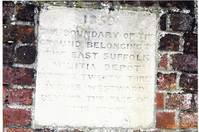
The first
one reads:
'1859
THE BOUNDARY OF THE
GROUND BELONGING TO
THE EAST SUFFOLK
MILITIA DEPÔT
EXTENDS TWENTY THREE
INCHES WESTWARD
BEYOND THE FACE OF
THIS STONE.'
 Photograph courtesy
Mike O'Donovan
Photograph courtesy
Mike O'Donovan
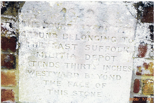
The second one [which seems to have its
corners trimmed to form a cartouche] reads:
'1859
THE BOUNDARY OF THE
GROUND BELONGING TO
THE EAST SUFFOLK
MILITIA DEPÔT
EXTENDS THIRTY INCHES
WESTWARD BEYOND
THE FACE OF
THIS STONE.'
They are all that remains of the historic building.'
Our thanks to Mike for finding these specimens and, indeed deciphering
the weathered lettering. The circumflex accent over the 'O' of 'Depot'
is a remnant of the French dépôt,
from Old French depost, from Latin dēpositum, something deposited, from
neuter past participle of dēpōnere, to put down, deposit. It's
interesting that the word as inscribed has, meanwhile, lost its acute
accent over the 'e'.
[UPDATE 12.2.2012: We are
indebted to The Ipswich Society slide collection (see Links for their Image Archive) for this
undated
photograph to
complete the Militia Depot set.]
 Photograph courtesy The Ipswich Society
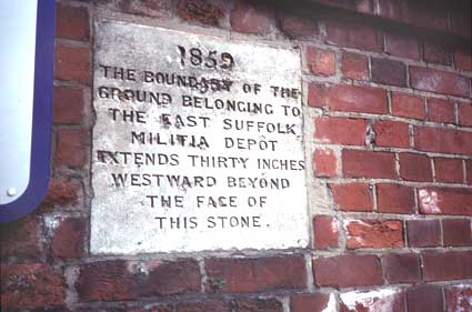
It reads:
'1859
THE BOUNDARY OF THE
GROUND BELONGING TO
THE EAST SUFFOLK
MILITIA DEPÔT
EXTENDS THIRTY
INCHES
WESTWARD BEYOND
THE FACE OF
THIS STONE.'
We believe that this example is
distinct from the one above it because, although the texts are
identical, the shape of the stone and the surrounding brickwork appear
to differ.
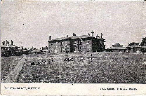
Fortunately, Ed Broom's excellent Ipswich In Old Postcards website (see
Links)
has a photograph (postmarked 1907) of
the Militia Depot:
The Suffolk Regiment was originally raised by the Duke of Norfolk in
1685, as the 12th Regiment of Foot, to suppress the threatened Monmouth
Rebellion. Their first stations were at Great Yarmouth and Landguard
Fort in Ipswich. King James II was a Catholic King and many of its
original officers were Catholics but when he fled to France, the whole
army, including this Regiment, would not support him further.
Their first actions were to be in Ireland actually fighting against
James. They stormed Carrickfergus Castle and were in the Battle of the
Boyne on 6 July 1690. Gradually the links to Suffolk strengthened as
more and more recruiting was done in this County. In 1782 it became the
East Suffolk Regiment but the Depot of the Regiment was finally
established at Bury St Edmunds in the Gibraltar Barracks in 1878.
The official title became the Suffolk Regiment in 1881. The West
Suffolk Militia became the 3rd Battalion and the Cambridgeshire Militia
became the 4th Battalion. By 1900, 90 percent of the men came from
Suffolk.
The 4th Battalion of the Territorial Force (later the TA) was
established in 1908 in East Suffolk and the 5th Battalion in West
Suffolk.
The 1902 map below shows that the Artillery
Barracks relating to Barrack Lane and Barrack Corner on Nowrich
Road/St Matthews Street (the area now occupied by Geneva and Cecil
roads) stood opposite the Militia Barracks on Anglesea Road.
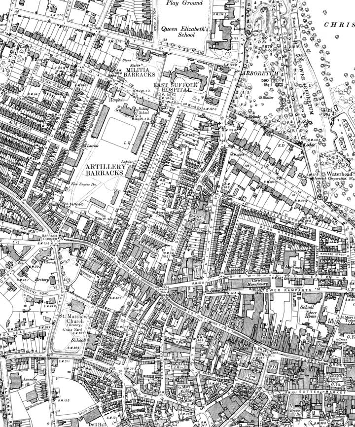 1902
map
1902
map
In modern times, Ipswich (Public)
School runs The Lodge Day Nursery which caters for children from three
months to three years; it is housed in what was originally the
Adjutant’s house from the former Militia Barracks, now Ivry Lodge, 38,
Ivry Street.
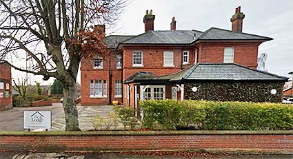 38 Ivry Street
Click for more about Boundary markers,
particularly of the Artillery Barracks.
Around the time of the Napoleonic Wars (1803–1815), there
were two
other less permanent barracks in the town. One was Stoke Bridge Maltings, situated by the
river, which were converted for the purpose. The buildings later
reverted to maltings. There is no visible evidence today of the second
site: a wooden hutted camp known as St
Helen’s Barracks that
was
situated at the top of Albion Hill, just north of Woodbridge Road
in the vicinity of Brunswick Road (which still has a kink in the
carriageway to indicate the extension of the road after the demise of
the barracks), Belvedere Road (formerly
Parade Terrace) & Parade Road, which still exists. This too
closed about 1815.
See also Rushmere Baptist
Chapel for a historical footnote about troops on Rushmere Common.
Home
Please email any comments
and contributions by clicking here.
Search Ipswich
Historic Lettering
©2004
Copyright
throughout the Ipswich
Historic Lettering site: Borin Van Loon
No reproduction of text or images without express written permission