Norwich
Long missing from the Ipswich Historic Lettering website, almost
all of these photographs were taken on a single walk around the city
centre in the June 2013. The massive task of building the page and
researching the examples was finally completed six years later. It does
not seek to be comprehensive, but to illustrate the huge variety of
historic lettering visible in the city.
Needless to say, this page represents a time capsule and some changes
have occurred in the intervening years.
Norwich is the county town of Norfolk, situated on the River
Wensum. From the Middle Ages until the Industrial Revolution, Norwich
was the largest city in England after London, and one of the most
important. Norwich is the most complete medieval city in Britain
and it has notable cathedral. The fabric of the city centre is rich in
historic
lettering, including enticing street nameplates.
 2013 images
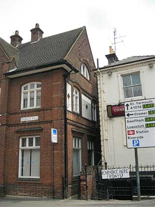
2 Recorder Road. Corner
with 120 Prince of Wales Road (the Compleat Angler pub); note the
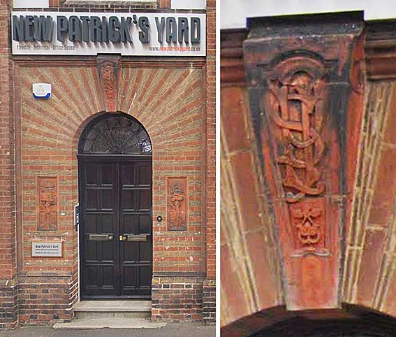
uncomforatble closeness of the twobuildings. ‘New Patrick’s
Yard’: ‘1912’ is the date on the gable end (not seen by us). The
decorative
brickwork entrance has the monogram ‘OSLJ’ (not necessarily in that
order) in
its terra cotta keystone with two matching tablets on each side of the
door showing trees.
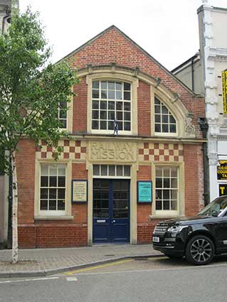
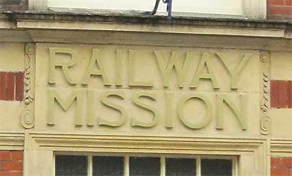
79 Prince of Wales Road.
'RAILWAY MISSION' in large, relief capitals above the
central
door is part of a well-preserved building, with a fine Art Nouveau
facade It is still
in use as the Prince of Wales Road Evangelical Church.
As with most East Anglian towns and cities, the railway station in
Norwich was built outside of the immediate centre because its main use
was not for passengers, but for goods, especially livestock, which
needed space to be penned nearby until the time for their journey
began. There was another station on a different line closer to the city
centre, but it is Thorpe station that has survived. As in Cambridge and
Ipswich, where the main stations were similarly placed for the same
reason, the area became home to dozens of rows of terraced houses, for
workers on the railway and in the industries that the presence of the
line generated. Although the Church of England was not slow to respond
to what it saw as the pastoral needs of these workers, there were
plenty of other denominations elbowing for their attention. For a
start, many incomers were Catholics, and it was in the 19th century
that the Catholic population of the city ballooned. But it was also the
time that the congregational chapels took off, and although many of
them have fallen prey to demolition in recent decades, there are some
interesting survivals, including this little Railway Mission chapel of
the 1890s. Prince of Wales Road, like Princes
Street in Ipswich, was
built specifically to connect the railway station with the heart of the
town, and still today this chapel is a familiar sight for pedestrians
en route between one and the
other. Happily, it is still in use for its
original purpose; as the Prince of Wales Road Evangelical Church, it
maintains two services every Sunday. [Information
from Simon Knott's Norfolk Churches website (see Links).]
(The Railway Mission still exists as a national organisation – not
now connected to this building.)
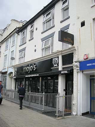
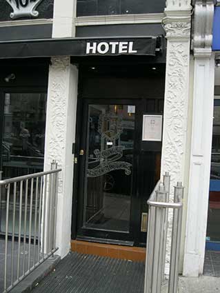
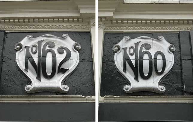
60-62 Prince of Wales Road.
Night club and Hotel Belmonte. Decorative mouldings on pilasters at
hotel entrance with the hotel name frosted into the glass door.
Above the shop-front: large, bulging, three-dimensional scrolling,
tiled
panels bearing ‘No 62’ and ‘No 60’. A sneaky use of the superior 'o'
inside the top of the 'N'.
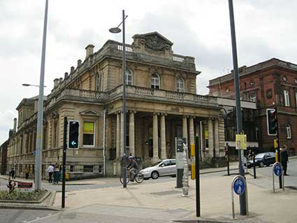
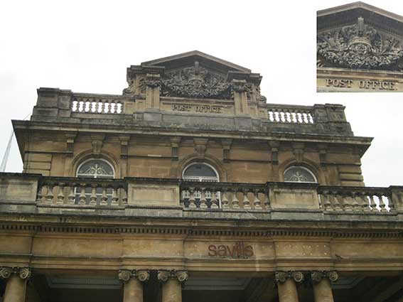
Hardwick House, Agricultural
Hall Plain. A grand neo-classical stone building; former ‘POST
OFFICE.’ (carved into the pediment in relief capitals below an
elaborate crown with swags of flowers in stone). Hardwick House was
designed by Philip Hardwick and it opened in January 1866 as Harvey and
Hudson’s Crown Bank, later taken over by the Post Office which was
there for almost a century. Savills has been operating in Norwich since
1950 and moved out of the building in 2018. Parts are residential.
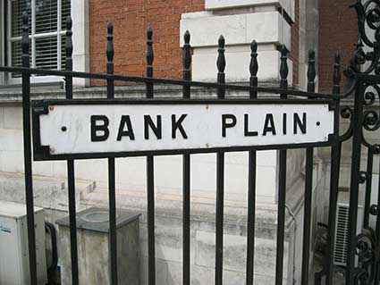
‘BANK PLAIN’ street nameplate
on railings outside former bank building by E. Boardman & Son and
Brierley & Rutherford, 1929 (and extended by Fielden & Mawson
in 1984-85). Red brick with Portland stone detailing (Listed Grade II).
Barclays Bank has left and it is now a conference and event venue
operated by the OPEN Youth Trust. Only a few yards from Hardwicke
House. Typical Norwich cartouche-style street nameplate in cast iron.
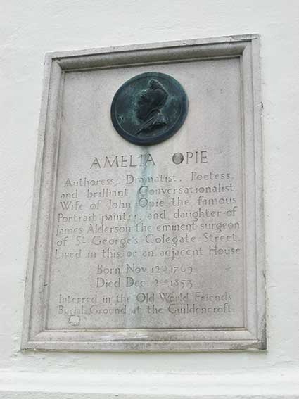
Commemorative plaque on Opie House, 26
Castle Meadow. ‘AMELIA OPIE; Authoress. Dramatist. Poetess. and
brilliant Conversationalist. Wife of John Opie the famous Portrait
painter. and daughter of James Alderson the eminent surgeon of St
George’s Colegate Street. Lived in this or an adjacent House; Born Nov.
12th 1769; Died Dec. 2nd 1853; Interred in the Old World Friends Burial
Ground at the Guildencroft.’ Copper relief porait in roundel. The
plaque and roundel are set above the ground-floor rustication to the
left of Opie House at the corner of Opie Street (building is Listed
Grade II). Amelia Opie is seen in profile wearing a peaked Quaker
bonnet, based on the 1829 bronze medallion by David d’Angers, who in
1836 carved a more idealised marble bust, versions of which are in the
Musée des Beaux Arts, Angers and the Castle Museum Norwich, acquired
2008. The date of the plaque is not known but H.A. Miller had begun
producing these plaques with that to George Borrow in 1913. Opie House
had been acquired by Mr Keefe, a solicitor, in 1932 by which date the
plaque was presumably in place. (Description from Norfolk & Suffolk
Public sculpture website (see Links).
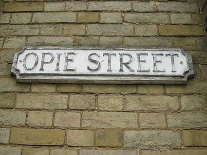
Above right: ‘OPIE STREET’ street
nameplate mounted on shaped board on the white brick of Castle
Chambers. Opie Street was originally called Devil’s
Steps but was renamed after a local girl, Amelia Opie – see above.
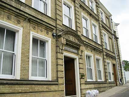
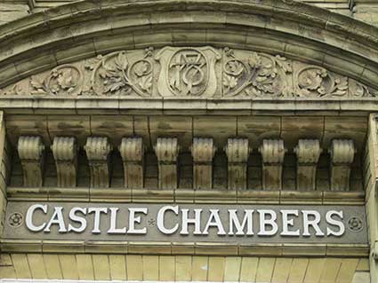
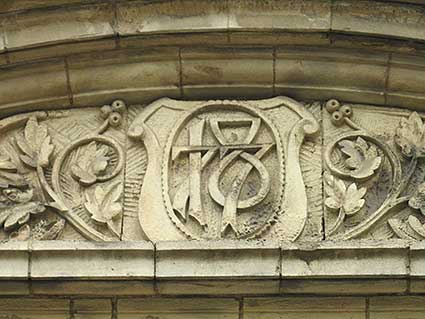
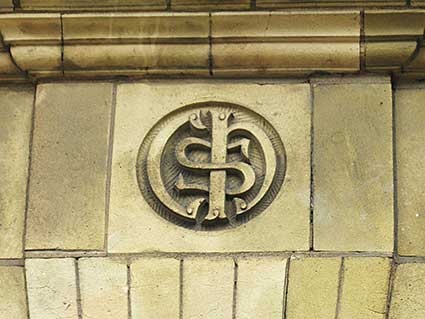
Castle Chambers, Opie Street.
This building is Listed Grade II and was built in 1877 for solicitor
Sydney Cozens-Hardy who had founded his practice in 1873. The building
features yellow/buff brick with terra cotta decoration. The firm of
Cozens-Hardy LLP continues to occupy the building. On
the main entrance to Castle Chambers, the pediment
bears the building name lettering in relief, picked out in colour with
numerals above : a fine date monogram of '1877'; note the
flattened top of the '8'. The ‘SCH’ monogram (for Sydney
Cozens-Hardy) is in circle centred above each window
and doorway at ground and first floor level.
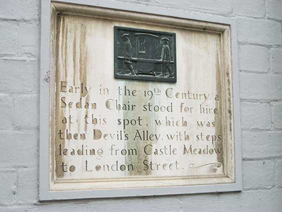
Corner of Opie Street and
London Street:
Sedan chair plaque. ‘Early in the
19th Century, a Sedan Chair stood for hire at this spot. which was then
Devil's Alley, with steps leading from Castle Meadow to London Street.’
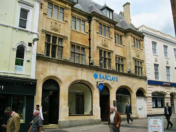
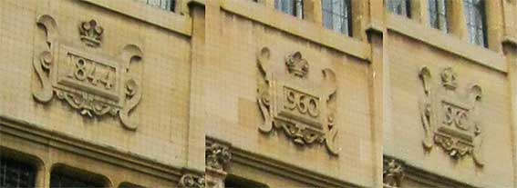
57 London Street.
‘1844’; ‘1960’; ‘1900’. Dated plaques above the second storey windows
of this sandstone building.
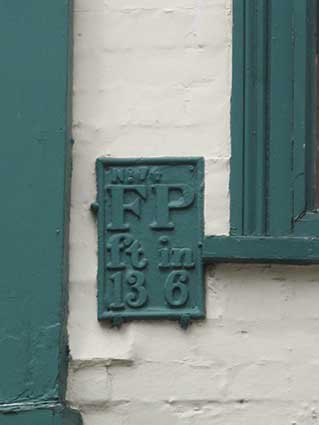
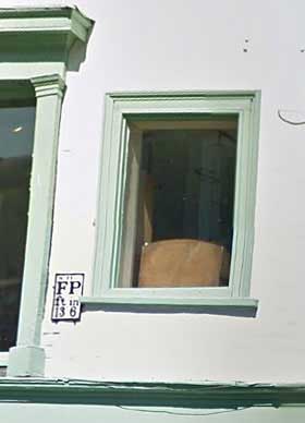
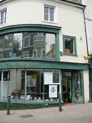
53 London Street (junction with
Bedford Street): Fire Point plate, ‘No. 74; FP; 13ft,
6in’. Overpainted in the green of the window surrounds and later
restored to the original black characters and frame on a white
background.
‘Hydrants
Although an Act of 1774 required each parish to maintain their own
fire-fighting appliance, to be used by the local citizens when
required, fire fighting was largely the responsibility of the insurance
companies. By the mid 19th century the police were charged with
providing a fire fighting service and wore distinctive uniforms
(usually styled on naval practice). Water supplies for fire fighting
were something of a problem but from the 1830s on most towns included
bye-laws to force the water supply company (whether private or owned by
the town) to fit hydrants to the water mains. From about the 1890s the
hydrants were usually marked by a cast metal plate mounted high up
(typically at the hight of a second floor window) on a nearby wall.
Early examples were white with black markings, usually the letters F H
(‘Fire Hydrant’) or F P (‘Fire Point’) and a number such as 7 0
indicating the distance in feet between the hydrant and the plate.
During the Second World War any suitable water supply was marked by the
letters 'E.W.S.' painted in white or yellow in letters about two feet
(60cm) high on a suitable nearby wall. This marking was still seen into
the 1960s on bridges over rivers and on walls close by ponds and the
like. After the second world war a national standard was introduced
consisting of a cast metal plate about ten inches (25cm) high by six
inches (15cm) wide. This plate is yellow with a large letter H in black
and the distance to the hydrant in smaller black numbers between the
lower legs of the H. In some cases the older F P plates have been
painted yellow with the lettering picked out in black, however as they
are often hard to reach many remain in the original black and white.
The post war hydrant plates are often seen mounted on stubby concrete
posts set into the pavement. [Notes
taken from: https://www.igg.org.uk/rail/00-app1/st-furn.htm]
Scroll down for a Fire Point plate at Watts Court. Note also the
vestigial 'E.W.S.' (Emergency Water Supply) sign in Lower Orwell Street, Ipswich. There is another 'EWS' example in Appleby-in-Westmorland.
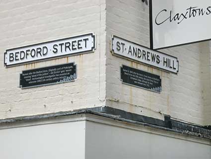
‘Bedford Street’ and St Andrews Hill’
cartouche-style, cast iron street nameplates. With explanatory
historical panels below.
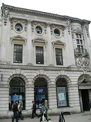
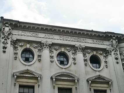
30 London Street: former London
And Provincial Bank. Built from Portland stone, and designed by
the Norwich architect George Skipper (see also the Royal Arcade, below)
in 1906/08.
Listed Grade II: ‘Portland stone. Roof not visible. 3- storeys. 4 bays.
Rusticated
ground floor with door in right-hand bay with marble Doric columns
supporting architrave and broken pediment in round- headed recess.
Ground floor windows in semi-circular hollow-chamfered arches with
Keystone. Sash windows with pedimented surround and Vitruvian scroll
stringcourse at first floor. Oval windows at 2nd floor. The first and
2nd floor windows are divided by attached Corinthian columns. 3-tier
bowed window above entry supported by putti. Extravagant use of swag
decoration at 2nd floor level. Modillion fascia cornice displaying
‘London and Provincial Bank’. Fine ground floor plaster-work ceiling to
original banking hall.’
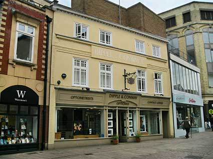
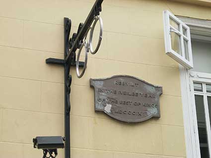
19 Castle Street: Dipple
and Conway Ltd, opticians' premises for three
generations
bears the company name in stylish characters and an excellent hanging pince-nez sign. The plaque next to
it reads:
‘REBUILT
IN THE JUBILEE YEAR
OF THE BEST OF KINGS
MDCCCIX.' [1809 ; George III]
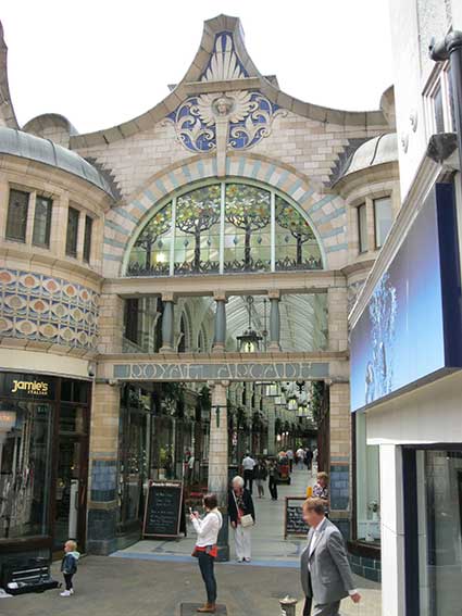
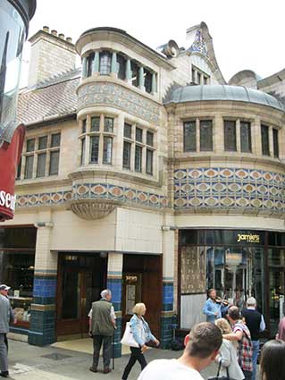
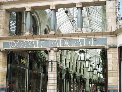
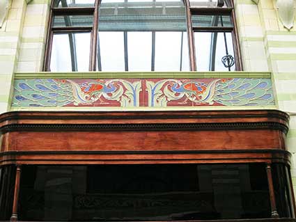
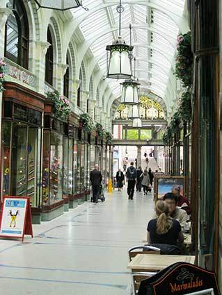
Royal Arcade, junction of
Castle Street, Arcade Street, Back of the Inns.
'Designed by local architect George Skipper in the Arts and Crafts
style popular at the end of the nineteenth century, the Royal Arcade
was built on the site of an old coaching inn and was unveiled on the
25th May 1899. On the next day the Eastern
Daily Press newspaper reported that ‘The general view of it is
pleasing in the extreme, and there can be no doubt it will prove a
permanent attraction to visitors, no less than to the townsfolk’.
Viewed from Gentleman's Walk the Arcade's façade is unremarkable and
offers little hint of the architectural extravaganza to be found
within. The single storey entrance opens up almost immediately into the
arcade itself, two storeys in height, 247 feet (75 metres) in length
and tiled throughout in pastel shades of greens and creams. With its
fully glazed roof supported by slim timber arches the whole interior is
light and airy.
The shop fronts are all to an almost identical design and are lightly
framed in a rich mahogany or similarly coloured wood. They project
slightly forwards into the arcade, with large bowed windows and are
quite exquisite. Above each and elsewhere in the arcade are panels of
decorative coloured tiles depicting peacocks and flowers, manufactured
by Doulton and designed by the ceramic sculptor W. J. Neatby, perhaps
best known for the tiles in Harrods food hall in London. The hanging
lanterns and flooring are new, dating from the extensive restoration of
the Arcade in the late 1980s.
At the far end of the Arcade, and over the entrance from that end, is a
large semicircular window, glazed with a mosaic in stained glass
depicting trees and birds. On leaving the Arcade here and looking back
one is confronted by a most spectacular façade, which extends to the
properties to either side, with more tiles and the aforementioned
window, all topped by an angel with wings reaching to the sky. Just
inside the arcade from the Gentleman's Walk entrance is Langley's toy
shop, which has had a presence in the arcade, though originally as
Galpins, ever since the arcade opened in 1899.
In medieval times the importance of Norwich as a provincial centre had
been assured, in large part due to the prosperity brought by the
textile trade in and around the city. The road at the lower end of the
marketplace was then known as Nether Row and was a natural location for
the fine houses and coaching inns which were built as a result of this
trade. By Georgian times the city had become a fashionable shopping
destination, and there were at least four such inns, together with
shops selling luxury goods, along this side of the market, which by now
had been renamed as Gentleman's Walk. The inns had long yards to the
rear, leading to a street aptly named as Back of the Inns, with stables
to accommodate the changes of horses for the stagecoaches. The largest
of the inns was the Angel, possibly dating back to the fifteenth
century or even earlier. The Angel was not only a coaching inn but also
served as a venue for public meetings, the local headquarters of the
Whig party, and a place of lively entertainment.
In 1840 the Angel was sold, renamed the Royal Hotel in celebration of
the marriage of Queen Victoria to Prince Albert, and refurbished ‘with
every convenience for the reception of families and commercial
gentlemen’. By this time the era of travel by stagecoach was almost at
an end. The arrival of the railways had reduced the travel time between
Norwich and London from fourteen hours to only a fraction of that and,
in early 1846, the Norfolk Chronicle
announced that ‘All the coaches between Norwich and London have ceased
to run’. In that same year a new frontage was built to the Royal, and
the hotel remained in business there until 1897, when it moved to newly
built premises at Bank Plain, closer to the main railway station. It
was on the site of the old hotel and its yard that the Royal Arcade was
opened just two years later. The hotel's frontage was retained and
still serves as the entrance to the arcade from Gentleman's Walk.'
[Notes from https://www.norwich360.com/royalarcade.html]
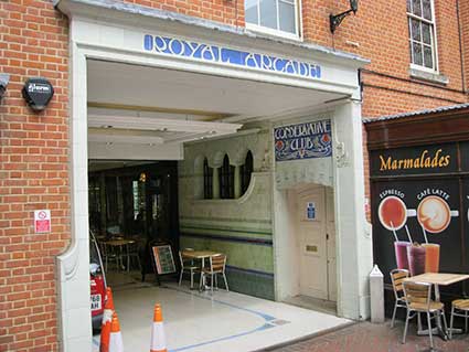
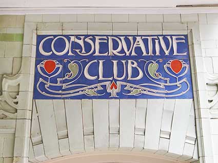
Royal Arcade,
Conservative Club entrance (Gentleman's Walk end).
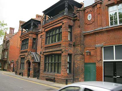
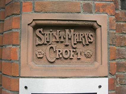
13 Chapel Field North: St
Mary’s Croft, overlooking Chapefield Gardens. This
house is Listed Grade II: ‘Late 19th century red brick
and pantile, two storeys and
attic. Three bays with smaller recessed central bay. Important example
of Tudor Revival. Moulded assymetrical porch with curvilinear gable and
finials. Mullion and transom windows with hoodmoulds. String courses
made of moulded brick panels. Decorative saw tooth cornice. Second
floor attic verandahs in outer bays with primitive carved posts.
Central dormer with curvilinear gable; these gables also at ends of
house with stacks. Verandahs have hipped tile hung roofs with
pinnacles.’
St Mary's Croft was
built by Captain Crowe in 1881, incorporating the walls of an earlier
building. It stands out because of the two 2nd floor verandahs with
carved cornerposts, low balustrading and hipped tile-hung roofs with
pinnacles. The boundary walls and railings of this property are also
Listed. The deep carving of the relief capitals on the name plaque has
resulted in the downstroke of the 'N' to become detached; it is still a
fine decorative piece of lettering.
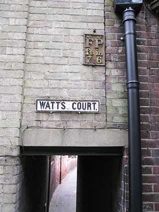
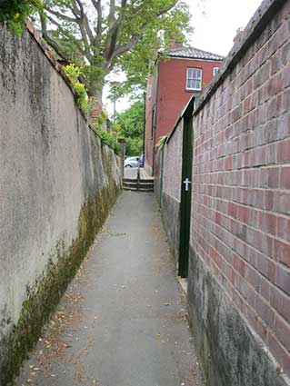
Watts Court. Fire Point
plate, ‘No. 27; FP; 7ft 6in’. Entrance to ‘WATTS COURT.’ by 11 Chapel
Field. Above right: Watts Court, the passage.
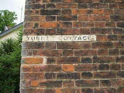
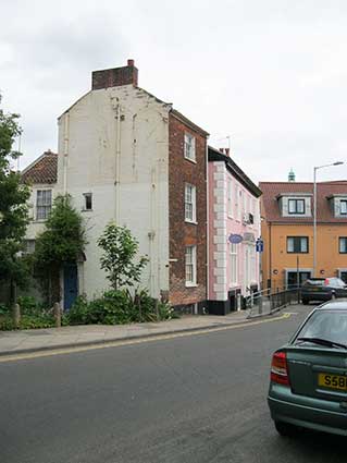
66 Bethel Street: ‘TURRET
COTTAGE’. Listed Grade II: 'Former house now office. Early C19. Red
brick painted on west facade. Pantile roof. Corner site. 3 storeys plus
semi-basement. Single bay. Door in west elevation with semi-circular
fanlight and wrought-iron trellis-work porch. Sash windows with glazing
bars and rubbed brick flat arches in Bethel Street elevation. Fascia
cornice.'
The degraded capital letters are painted on a white background
following the course of the brickwork. The state of the
side wall suggests that another property occupied the space to the left.
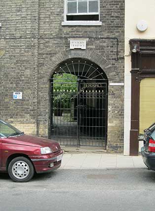
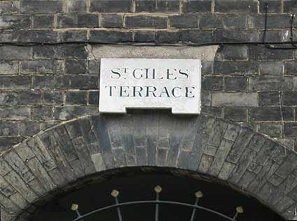
'St Giles Terrace', Bethel
Street: arched entry with name tablet above. Tucked away behind
the
buildings on its north side of Bethel Street is a row of town houses
known
as St Giles Terrace, built during the early part of the 19th century.
Facing west, its grey brick facade was designed with a series of five
brick pilasters supporting a shallow stone pediment above a plain
architrave.
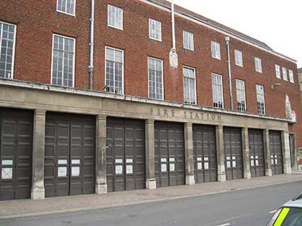
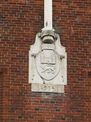
30 Bethel Street: The
Old Fire Station. Now Sir Isaac Newton Sixth Form
College. At a
higher level is an Art Deco stone feature with the Norwich City coat of
arms (castle with rampant lion below on a shield) and the date ‘AD
[below the shield] 1934’.
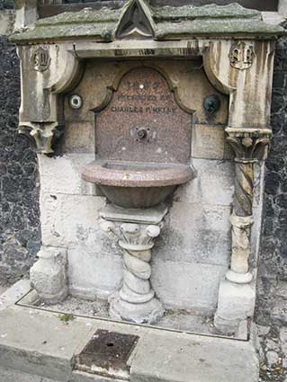
Gaol Hill: Drinking
fountain, east end of Guildhall. ‘1859; presented by Charles P. Melly;
Above: ‘C.M.’ [Charles Melly]; ’S.R.’ [Salve Regina: 'God save the
Queen'].
The panels with shields are worn but the coats of arms on the right can
be made out as those of the City. The drinking fountain is also badly
worn. The decorative fountain has a mock-Gothic architectural frame and
the red granite drinking trough is supported on a twisted all'antica or
early Christian column. This is very much more elaborate than the
simple granite fountains which Melly had provided for Liverpool,
discussed below. It may have been designed by Robert Kerr, the
architect responsible for the clock tower of 1850.
The provision of a drinking fountain fits with the Victorian response
to the discovery in 1854 by John Snow (1813-1858) that cholera was
spread by contaminated drinking water, and with a philanthropical
movement initiated by Charles Pierre Melly (1829-1888). Melly was born
in in Tuebrook (a suburb of Liverpool), to a Swiss father from Geneva,
who had gained English citizenship. Charles Melly became a cotton
merchant in Liverpool & Manchester, an officer in the Childwall
Rifles and a philanthropist. He was involved in planning Sefton Park,
Liverpool, having persuaded Lord Derby to donate land. He founded the
North East Mission; the first night school, in Beaufort Street; and the
Liverpool Gymnasium, in Myrtle Street. Concerned for Liverpool’s poor,
he provided free playgrounds for children and benches for the elderly,
and, having seen the difficulties of the lamplighters, he introduced a
system he had seen in Geneva, replacing ladders with long poles. In
1852, having been told of the dock workers’ and immigrants’ need for
fresh drinking water - their only alternative being the public house -
he proposed the provision of free drinking fountains, based on those in
Geneva. Initially, he set up a number of taps near the docks, providing
fresh water, but these proved so popular (on one occasion, in a 12 hour
period, they were used by not less than 2336 people!) that they wore
out in two years. In 1854, at the south end of Princes Dock, Melly set
up the first red granite fountain, and by 1858 he had supplied
Liverpool with 43 fountains, with water spouts including lions’,
tigers’ and satyrs’ heads, and all at a cost of £10 each. Attached to
dock walls, church walls, railway station buildings and bridges, and
other places where they would be most useful for the poor. Melly’s fame
spread, and a paper which he presented to the Liverpool meeting of the
national Association for the Promotion of Social Science in 1858,
outlining his work in the city, was taken up by Samuel Gurney MP
(1813-1882) a nephew of the Quaker prison reformer Elizabeth Fry, MP
for Penryn, 1857-65, and a founder of the Metropolitan Drinking
Fountain & Cattle Trough Association. Although Gurney lived in
Surrey and at Regent's Park he was one of the members of the Norwich
based Overend and Gurney Bank not to have been damaged by their crash
in 1866, a connection which may have prompted Melly to have presented
one of his drinking fountains to Norwich and may explain its prominent
position at the east end of the Guildhall, still the City's town hall.
The need for the fountain is a further indication of the decline of the
city's once great textile business, which by the 1850s had failed to
keep up with Manchester in the use of the power looms. This resulted in
large-scale unemployment and unrest among the city’s weavers,
compounded by the appalling quality of the water, noted in a report for
the General Board of Health in 1851. The Wensum was 'thoroughly and
irremediably' polluted with domestic and industrial waste, although
piped water had become available following the establishment of a new
water company in 1850. Following Melly's example Samuel Gurney set up
London’s first fountain on the wall of St Sepulchre, Holburn in 1859.
Melly's example and Snow's discovery of the link between contaminated
water and cholera was to result in widespread commissions for fountains
and water pumps, including in Norwich the Gurney obelisk of 1860 on
Tombland (designed by John Bell) and that endowed by Sir John Boileau
in 1869 for the Newmarket and Ipswich roads. [Information from the Norfolk
& Suffolk Public Sculpture database (see Links)]
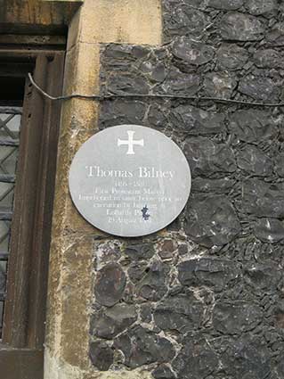
Above left: Gaol Hill,
Guildhall. Plaque at the upper right of the
Melly drinking fountain, east end. ‘Thomas Bilney, 1495-1531, First
Protestant Martyr Imprisoned in the vault below prior to execution by
burning at Lollards Pit on, 19 August 1531’. Lollards Pit was on
Riverside Road, occupied today by the Bridge House public house. Bilney
was a well-known preacher against idolatry; at Ipswich, he denounced
pilgrimages to popular shrines like Our Lady of Walsingham and warned
of the worthlessness of prayers to the saints – he was pulled from the
pulpit of St George’s Chapel by some members of the congregation.
Thomas Bilney, a Norfolk man born near Dereham, was a Cambridge
academic. Like the Lollard priest William White before him, he was
convinced that the Church had to be reformed. Arrested, and taken
before Cardinal Wolsey, he recanted denied his beliefs. But,
characteristic of many who recanted when initially faced with
execution, he began preaching heresy in the streets and fields. Bishop
Nix of Norwich had him arrested, and this time there was no mercy. Like
other heretics Bilney was tried by the Church, but given to the agents
of the State for execution. ‘Good people, I am come here to die’,
declared Bilney as he stood at the stake.
[https://www.edp24.co.uk/norfolk-life-2-1786/norfolk-history/62-lollards-pit-norwich-1-214172]
Bilney appears again in our Ipswich pages about the Chapel of St George
in St Georges Street.
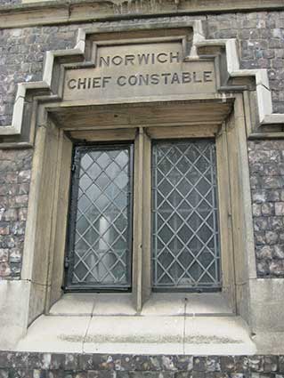
Above right: Gaol Hill, Guildhall. ‘NORWICH CHIEF
CONSTABLE’. Over a window to the left of the Melly drinking fountain.
The Guildhall is not just one of the finest buildings in the city, it
is one of the best of its kind in the land, but one which has been
neglected over the centuries. It is the largest and most elaborate
medieval city hall outside London, reflecting Norwich’s status as one
of England’s wealthiest and most powerful cities. For hundreds of years
this was where the people who controlled the city met in their grand
council chamber, where those in trouble stood in the dock, and where
prisoners were held in both an open jail and dungeons before being put
to death, tortured or sent to the other side of the world. It was
constructed between 1407 and 1413 and served as the seat of city
government (also court and gaol) from the early 15th century until
1938, when it was replaced by the newly built City Hall. At the time of
the building's construction and for much of its history Norwich was one
of the largest and wealthiest cities in England, and today the
Guildhall is the largest surviving medieval civic building in the
country outside London. Magistrates' Courts continued to be held in the
old Common Council Chamber until 1977 and prisoners were held in the
building until 1980. Clearly the Chief Constable had his offices at the
Guildhall, too.
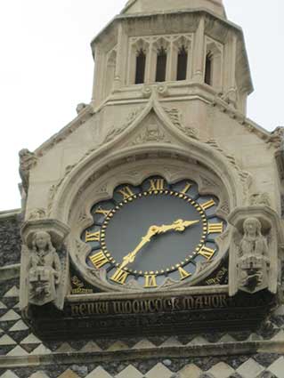
Gaol Hill, Guildhall Clock tower.
This grand stonework bears two angels holding the City coat of arms
with, on a scroll at the top, the date ‘1850’. The fine gold on
grey-blue clock face has lettering below it: SOLA VIRTUS … INVICTA’
[Virtue alone cannot be conquered]; ‘HENRY WOODCOCK MAYOR’ in Gothic
script.
New council chamber, 1536, clock tower 1850. Norwich had been
granted its first Charter of Incorporation in 1404, giving it the
status of a city and the right to elect its own mayor, collect its own
taxes and hold its own Courts of Law. The Guildhall was built from
1407-53 to house the courts together with the prisoners, as well as
offices for raising taxes, the civic regalia and the civic officials.
With three major chambers it was larger than any comparable
contemporary civic building. When the roof of the mayoral council
chamber collapsed in 1511 repair and rebuilding could be put off until
1535-1537. The new chamber’s eastern façade provided the building’s
major view, now partially blocked behind a taxi rank. It was decorated
with chequerboard flushwork and a large window, which was set over
decorative panels displaying coats of arms. As with other contemporary
schemes, the entrance to Cardinal Wolsey’ College in Ipswich and
Hengrave Hall, the place of honour in the centre was reserved for those
of Henry VIII. They were flanked to the right by those of the city,
still just visible - a castle over a lion supported by armed angels –
and on the left the Guild of St. George, under a helmet. The heraldry
was reflected in the four lights of the east window and served to
underline the importance of the Norwich guild of St. George. Granted a
royal charter in 1417 from 1452 the guild had been closely linked with
the government of the city, with each retiring mayor as the alderman
(head) of the guild. The base of the clock turret is dated 1850 and
supported by angels holding the city’s coat of arms. The gilded
inscription at its base reads HENRY WOODCOCK, MAYOR and on the base of
the clock SOLA VIRTUS INVICTA (Virtue alone cannot be conquered), the
motto of the Dukes of Norfolk, the premier dukes who, in spite of their
title, had no connection with Norfolk.
The elegant arched spire, apparently rebuilt before 1935, marked out
the east end of the Guildhall from the surrounding late Victorian
buildings and the market, before construction of the present City Hall.
Henry Woodcock (1789-1879) was mayor for 1849-1851. On the 17th April
1850 he offered to provide an illuminated clock ant turret, on
condition that the Corporation removed the false ceiling in the Council
Chamber in the Guildhall and laid open the new roof. By 2008 both the
iron support for the clock and its stone housing needed repair,
undertaken from July 2010 by Universal Stone and completed in December
2011. The deterioration of the stone was worse than had been expected
so that the stone casing had to be removed completely before
restoration could begin in summer 2011. [Information
from the Norfolk
& Suffolk Public Sculpture database (see Links)]
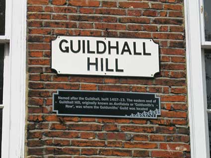
9 Guildhall Hill: street
nameplate above shopfront. A variant to the other
rectilinear cartouche-style, cast
iron nameplates in Norwich with more conventional curved quadrants
taken out of each corner. A heritage information plaque
has been mounted beneath it.
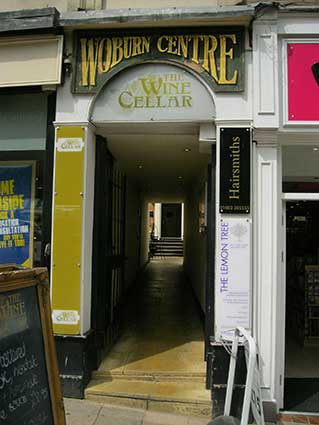
Between 7 and 8 Guildhall Hill:
‘Woburn Centre’ entrance. One of the courts and yards of old Norwich,
often associated with inns. Woburn Court is now occupied by eating and
drinking establishments. See also the 'Library' lettering at 4a
Guildhall Hill (below).
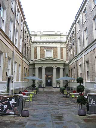
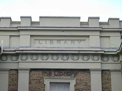
4A Guildhall Hill: ‘LIBRARY’
carved into stone cornice. The Norfolk and Norwich Subscription
Library was formed in 1886. The original subscription rate was £1 for
ladies over 18 and £2 for men. Fueled by voluntary subscriptions, the
building possessed many volumes of great value. In 1898, during the
August Bank Holiday weekend, a fire broke out in nearby Dove Street.
The fire quickly spread to the Library and within an hour the entire
building was gutted and most of its contents were destroyed. The
building was later restored at the cost of £1,719 and re-opened in
1914. The Library was indeed, the first public subscription library in
the UK and is a Listed building which has been brought to life,
sympathetically converted into a modern contemporary restaurant that
incorporates the historical features seamlessly.
Listed Grade II: 'Former library, now Court Office and Shops. 1837 by
J.T. Patience. Yellow brick with masonry dressings, Slate roofs,
Recessed block with long wings returning to the street-line having 4-
and 2-bay fronts. 2 storeys. Single wide bay. Central double-door with
tetrastyle Greek Doric portico with pediment. 3 steps up. The portico
frieze returns to become stringcourse on the facade supported by
pilasters. The centre of the facade projects with one sash window with
glazing bars and eared surround. 4 first-floor pilasters. Triple
frieze-cornice, the centre one displaying 'Library'. Pediment. Wings:-
3 storeys plus semi-basement, 11 bays, the centre 4 recessed. Sash
windows throughout with glazing bars and rubbed brick flat arches.
Masonry bands at ground and first floor. Parapet. C19 and C20 altered
shopfronts returning 3 bays along the wings. Carriage entry at extreme
left-hand side of street facades, C19 fascia between consoles above
left-hand shopfront. Corner and central pilasters. The shopfront to the
right of the carriage entry has a triglyph frieze extending across from
No. 1 Guildhall Hill. Decorative ironwork balustrading above frieze.
Sash windows throughout with glazing bars and rubbed brick flat arches
at first floor. Second floor windows beneath cornice.'
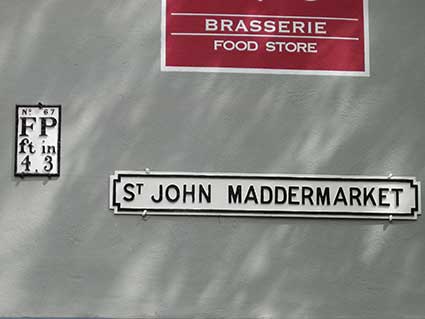
'St John Maddermarket'
street nameplate – near the crossroads with Pottergate,
Dove Street and Lobster Lane. Also Fire Point (water
hydrant) plate: ‘No. 67; FP; 4ft 3in’. The street name dates to the
early 15th century when the Guildhall was built and Maddermarket was
the
centre of the dyeing trade, madder being a red pigment obtained from
the
root of the Eurasian madder plant.
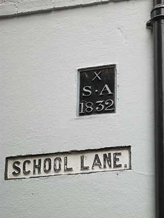
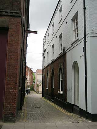
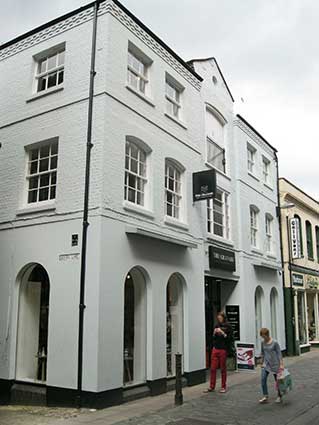
‘School Lane.’ street
nameplate and boundary marker plaque. This passageway runs between
Bedford Street (at the rear of Jarrolds store) and Exchange Street
(between Exchange Street Buildings – included below – and no. 33) and
is clearly signed at
each end, yet it doesn’t appear on modern maps. Note the unnecessary
full stop. The nearby plaque
reads: ‘X; S.A; 1832’ and is a parish boundary marker for the Church of
St Andrew which is situated nearby on the junction of St Andrews Street
and St Andrews Hill. To avoid risking damage to the nameplate and sign
during removal and reattachment, a modern cement render has been built
up around the signs.
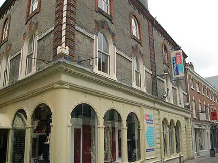
Corner of Bedford Street and Swan Lane:
Architectural photograph. Fabric Warehouse (now Turtle Bay). Note: Fire
Point plate just visible next to first floor window on Bedford Street
elevation.
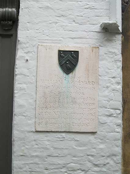
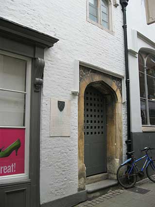
Bridewell Museum, Bridewell
Alley: William Appleyard memorial tablet.
William Appleyard was three times Sheriff and five times
City Mayor. William was the first Mayor of the City after it became a
shire incorporate in 1404. He owned lots of property in the city and
inherited from his father the house that now incorporates the Bridewell
Museum, famed for it’s finely-cut black flint bricks. William presented
the city with a great tree to aid with building the new Guildhall. He
also owned a lot of land to the south of the city, including Intwood,
Bracon Ash and Hethel. His father was given the rather odd
responsibility of providing the King with 224 herring pasties whenever
he visited the region.
Around 1325 a wealthy merchant named Geoffrey de Salle built a house
here, near the Church of St Andrew. In 1386 the house was enlarged by
William Appleyard, who went on to become the first mayor of Norwich
(1403-1435). Very little of the original 14th century building
survives, save the flintwork facade facing the narrow lane linking
Bridewell Alley and St Andrews Hill (both still paved with setts). This
is one of the earliest and finest examples of secular East Anglian
flintwork in England. Under the building is another 14th century
survival: the vaulted undercroft, used for storage and to hold inmates
when the house became a prison. Bridewell Prison was established here
in 1585 and was named after the London prison of the same name which
was built near St Bride’s Well. The Bridewell must have been a very
desirable property, as by the 16th
century it was owned by another Mayor of Norwich, Robert Gardener. Then
in 1580 it was sold to the Corporation of Norwich by John Sotherton.
The Corporation had a problem: the city was bursting with
transient beggars and poor residents, drawn by Norwich's reputation as
a bustling centre of commerce. But these beggars and poor people relied
on the city for charity.
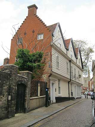
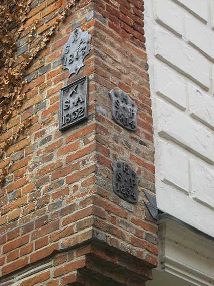
Corner of Princes Street and
Elm Hill: Building decorated with boundary
marker-plates. The plates are fixed to brickwork at first floor
level; note the crow-steps on the gable above.
The plates read:
‘X; S A; 1813’ [parish of St Andrew]
‘X; S A; 1832’ [parish of St Andrew]
‘H; S P; 1814’ [parish of St Peter Hungate]
‘H; S P; 1834’ [parish of St Peter Hungate].
N.B.: other small collections of boundary marker-plates can be seen on
buildings further down Elm Hill, presumably collected by the residents
during changes to or demolition of the original bearers of the markers.
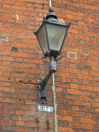
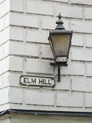
Above left: Princes Street
(opposite 56-57 building). Wall-mounted gas lamp
(now converted to electricity) with number ‘2073’ stencilled on
white-painted brick below.
Above right: Elm Hill.
Wall-mounted gas lamp on corner house at the top of Elm Hill (now a
café). The number ‘2049’ is stencilled on the lower body of the lamp;
situated next to the ‘ELM HILL’ street nameplate. Both examples appear
to have been replaced since the photographs were taken in 2013 by
larger lamps with amber-coloured opaque glass. Numbers are ‘2’ and ‘1’
respectively with new numbers stuck on the bottom of the front glass
panel. Do they look as good/authentic?
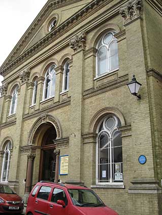
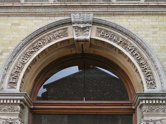
Princes
Street United
Reform Church. The extravagantly decorated arched entrance at
the
centre of the palladian facade features subtly-serif’d capital letters
floating over the carved floral features: ‘ENTER INTO HIS COURT WITH
PRAISE’ (a version of Psalm 100:4 KJV: ‘Enter into his gates with
thanksgiving’). The white brick frontage features pilasters with
equally extravagant Corinthian capitals below the cornice. Two more of
the street lanterns project from the side pilasters.
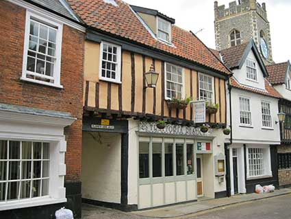
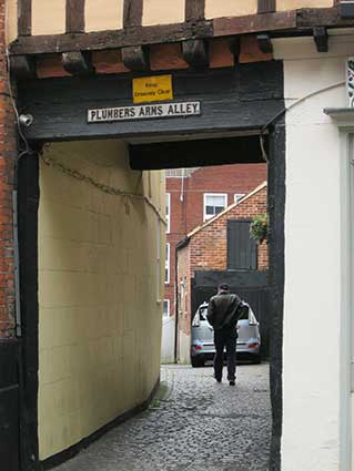
Plumbers Arms Alley, 20 Princes
Street. Runs into Waggon & Horses Lane (named after the
former inn of the same name). The alley is named after the Plumbers
Arms public house which used to be located here, with the first
recorded licensee having been Margaret Dawson in 1822. Two more
examples of numbered, wall-mounted gas lamps are visible.
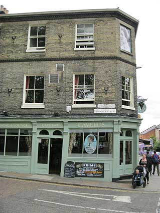
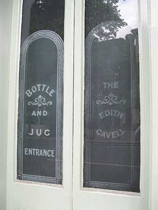
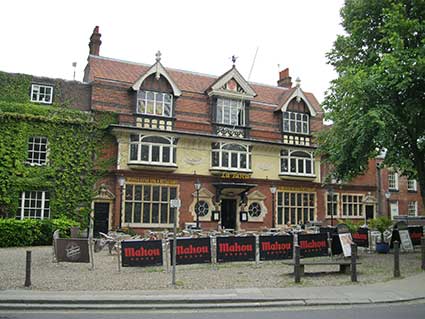
7 Tombland: the
Edith Cavell public house. Frosted door decoration (probably modern
adhesive vinyl?): ‘BOTTLE AND JUG ENTRANCE; THE EDITH CAVELL’. The
colour scheme has since changed.
Beside the Erpingham Gate in Tombland is a monument to Edith
Cavell, who was born just outside the city of Norwich. Cavell is famous
for her role in helping allied servicemen to escape from occupied
Belgium during World War I. She was eventually discovered and shot, but
later brought to Norwich Cathedral for burial.
Scroll down for other examples in Tombland (The Augustine
Steward
House, The Maids Head Hotel).
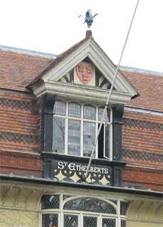
24 Tombland: 'ST
ETHELBERTS' lettered below the second storey window of the central
gable. Named after the St Ethelbert’s Gate in nearby Queen Street. This
gate to the Cathedral Close dates from c.1316. St Ethelberts House,
Tombland: This is a swagger Arts-and-Crafts style house of 1888, with a
welter of mullions and transoms, coving and gables.
Listed Grade II: 'Former use unknown, now restaurant and club. 1888 on
plaque by E.P. Wilkins [to the right]. Red brick and rendered. Hung and
plain-tiles. 2 storeys plus attic.
Symmetrical bays plus one bay. Central door with hood on consoles and
large shell moulding. Yard entry at extreme left with open pediment.
Circular windows with scrolled and pedimented surrounds and 6-light
mullion and transome windows at ground floor. First floor dentil
stringcourse across 4 bays. Oriel windows at first floor with swags
between. Coved cornice and decorated parapet. 3 large dormer gables
with casement windows: bargeboards with finial in outer bays and
central dormer with pediment. Mansard roof with decorated tiles. Single
right-hand bay:- door at extreme right with moulded stone surround and
broken pediment. 2 mullion and transome windows at ground floor. Canted
first floor window with brick pediment and apron . Dutch gable. 5 lamp
posts in front of facade.'
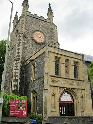
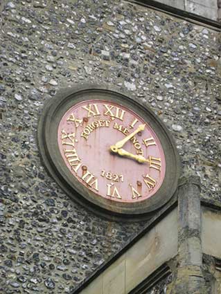
Redwell Street: ‘Forget
Me Not, 1827’ clockface, St Michael-At-Plea Church. 14th century church
with a rather distressed clockface; it looks as if the four studs are
made of iron and rust stains are evident. The red background was
probably a richer. deeper red, similar to that used on the information
board below it. The sign over the entrance door reads 'SHOP & CAFE'.
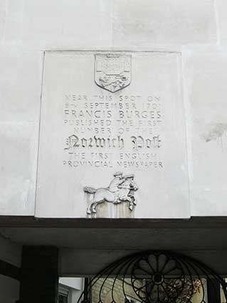
3-7 Redwell Street: Clement
Court.
Plaque on modern clock: ‘Near this spot on 6th September
1701 Frances Burges published the first number of The Norwich Post, the
first English newspaper’. City arms at the top; horn-blowing rider on
horseback at the bottom of the plaque. The building is now Francis
House,
part of Norwich University of the Arts.
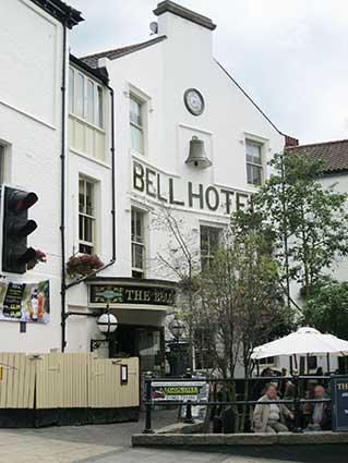
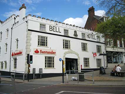
5 Orford Hill/Red Lion Street, Bell
Hotel. Large capitals in relief at the top of the
building ‘BELL HOTEL’ with projecting half-bell (Orford Hill: Santander
branch).
Large capitals in relief at the top of the building ‘BELL HOTEL’ with
half-bell and clock above on angled wall (Red Lion Street:
Wetherspoon’s pub).
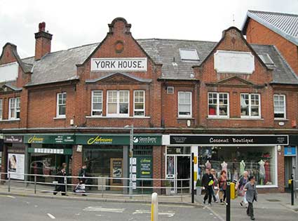
Junction of Red Lion Street
with Farmers Avenue and Castle Meadow (opposite the Bell Hotel).
‘YORK HOUSE.’ in capitals with a superfluous full stop
in panel in
gable. York House once used to be a pub known as the 'York Tavern' in
1884. From 1760 until 1807 it had been called the 'City of York' or
'York City'. By 1840 it was a shop but apparently became a pub once
again which was finally closed in April 1964.
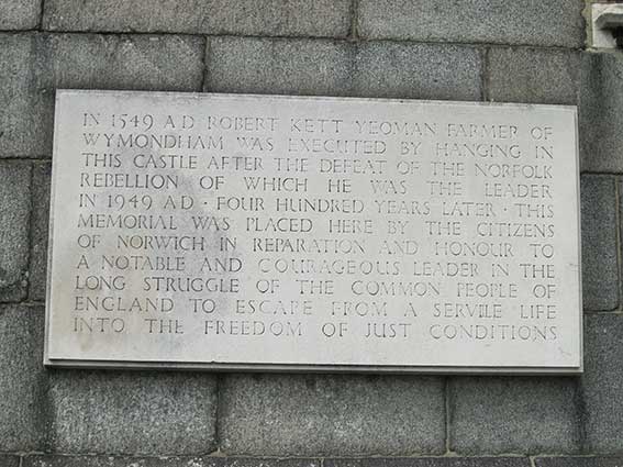
Norwich Castle plaque: ‘In 1549
AD Robert Kett yeoman farmer of Wymondham was executed by hanging in
this castle after the defeat of the Norfolk Rebellion of which he was
the leader In 1949 AD - four hundred years later - this memorial was
placed here by the citizens of Norwich in reparation and honour to a
notable and courageous leader in the long struggle of the common people
of England to escape from a servile life into the freedom of just
conditions’. Sited beside the main visitor entrance.
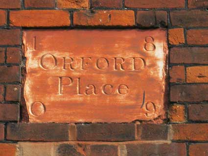
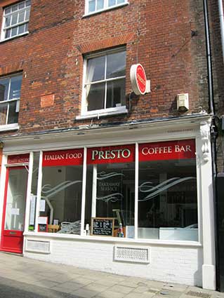
5 Orford Street: ‘ORFORD
Place, 1809’ plaque. The date numerals are placed in
each
corner; it looks as if the plaque was white and has been painted in a
slapdash manner with a terra cotta colour.
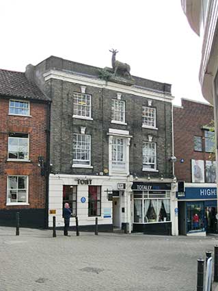
8 Orford Hill.
Architectural photograph: sculpture of a large stag at roof level (a
former inn?).
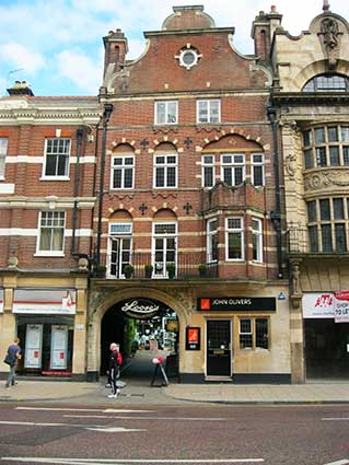
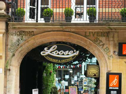
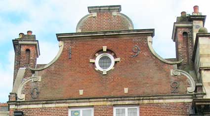
5 Red Lion Street
(formerly Loose’s cook shop). Above the arched carriage entrance:
‘SHOEING; FORGE; LIVERY; STABLE’ in metal characters attached to the
stone. On the decorative gable (5th storey) brickwork: ‘1902’ in large,
separated metal characters. Presumably an old coaching inn?
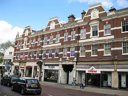
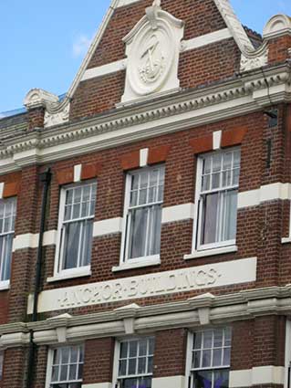
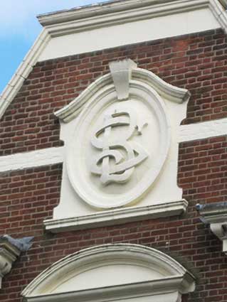
23-25 Red Lion Street: 'ANCHOR
BUILDINGS'. Roundels in pediments to side inscribed with intertwined
‘BS’ monogram (for Bullard and Sons, brewers). In cartouche set in
central pediment an anchor and chain with rocks a version of the
brewery emblem from 1868 on display at Bullard’s Anchor Brewery on
Anchor Quay. The street was widened and rebuilt from 1900 onwards. The
Anchor buildings were built by Bullards with the Orford Arms in the
left hand building. The Orford Arms (a Bullards pub) had been on the
site since at least 1865. William Grix was the licensee from 1900-1905.
The last licensee was recorded in 1937.
The monogram bears a striking resemblance to the design of that used by
Norwich brewer Steward & Patteson Ltd (as seen on Uncle Tom’s Cabin in Ipswich).
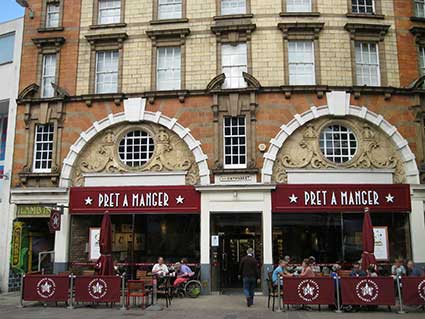
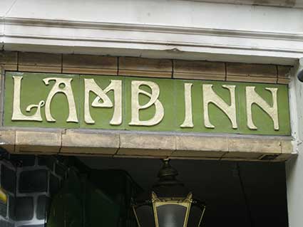
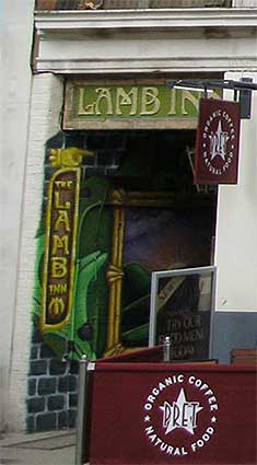
11 Haymarket: ‘LAMB
INN’ in ceramic tiling. Dated 1902 and apparently designed by George
Skipper, architect of the Royal Arcade and the London
And Provincial Bank, in London Street (see both,
above). The Baroque
flourishes make that seem entirely plausible. Clad in an eclectic mix
of coloured faience and stone. Reputed to be the best building in
Norwich not to be Listed (it is on the city council's Local
list). The Art Nouveau lettering fits the date of the building.
The name The Lamb takes the pub back to its 13th century origins when
it was known as the Holy Lamb. The pub building in Lamb Yard is dated
late 18th century.
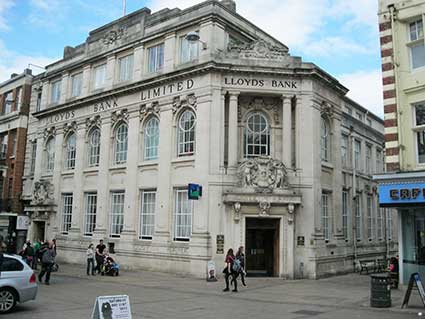
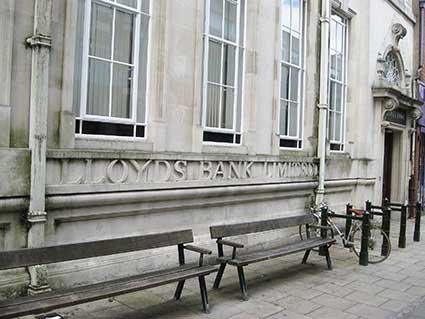
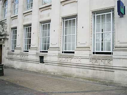
16 Gentlemans Walk, Lloyds
Bank building. Listed Grade II: ’1924 by H. Munro Cautley and extended
into Davey Place
in 1925. Stone. Slate and flat roofs. Corner site. 6 major bays, one
minor bay to left and corner bay to right. Corner and end entrances
with bolection bead and rod surround and lintol with figure-head
keystone supported on scrolls. Above the lintel is a cartouche
supported by putti. The ground floor has metal casement windows with
margin lights and flat arches having bead and rod decoration. Recessed
panels beneath the semi-circular arched first floor windows: scrolled
keystones and festoons in the spandrels. Square casement windows at top
floor. Glazing bars throughout. Heavy panelled pilasters dividing the
bays with simple frieze between first and second floors. Ziggurat
cornice with lion masks and fascia motif. Rusticated hollow chamfer
surrounds to windows above passage.’
The attached metal characters above second storey level read ‘LLOYDS
BANK LIMITED’ (shortened to ‘LLOYDS BANK’ on the 45 degree-angle
entance). Stone lettering is cut in relief: ’LLOYDS BANK’ appears twice
on
the Gentlemans Walk elevation below the ground floor windows and once
on the entrance below the cartouche. ‘LLOYDS BANK LIMITED’ runs down
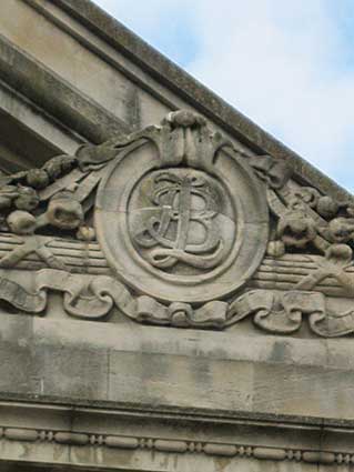
the Davey Place elevation. The monogram ‘LB’ is in a circle on the
upper pediment of the entrance, with ‘LLOYDS CHAMBERS’ in metal
characters above the side entrance.
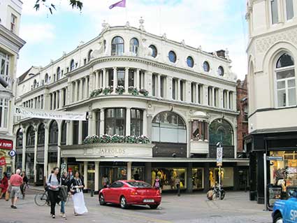
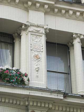

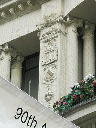
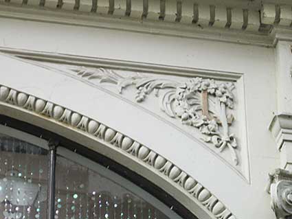
Corner of Exchange Street and
London Street: Jarrolds store. ‘JARROLDS’
moulded into the curved frontage at first floor level. Along Exchange
Street above the ground floor windows: ‘JARROLDS; BOOKSELLERS;
BOOKSELLERS; STATIONERS; JARROLDS (repeated). Pillasters at second
floor level bear decorative open book motifs with cartouches bearing
the names: ‘GLADMAN’, ‘BREWER’, ‘JOKAI’, ‘MARSHALL’, ‘SEWELL’,
‘FARNELL’, ‘SPILLING’. The spandrells around the semicircular windows
at first floor level bear ‘J’ and ‘L’ (for Jarrolds Ltd) intertwined
with olives, leaves and scrollwork then oak leaves, acorns and
scrollwork, respectively. Once again, this is the work of architect
George Skipper, creator of the Royal Arcade. The shop has been well
described by Stefan Muthesius: 'Skipper provides a most sophisticated
reflection on a problem which had bothered designers for many decades.
Ever since progress made possible large sheets of glass, store windows
were made as large as possible to display the goods inside and to let
the light in. But such a shop front might look flimsy. By way of a
complex series of supports, Skipper gives the impression of reasonably
eighty construction, while still getting across that we are looking and
into a department store. Lastly, its delicacy and relatively modest
overall size were meant to distinguish form the largish and squarish
factory piles.’ Skipper adapted the classical orders setting Ionic
above the more manly Doric. Ionic was appropriate for the upper part,
since it was traditionally linked with wisdom and so celebrated the
firm's connection with books since the names inscribed in the
cartouches (as noted by Jolley) are of authors published by Jarrolds.
The following illustrative list (all published by Jarrolds of London)
was compiled from the Abebooks website: Dr C. Brewer: History of France: political, social and
literary history to 1874, (n.d); F.J. Gladman: School work; I. Control and teaching; II.
Organization & principles of education, 1886; Maurus
Jokai: Green Book or Freedom under
the Snow, 1897; Saunders Marshall: Beautiful Joe, 1907; Mary Sewell
(mother of Anna): a number of books including Mother's Last Words; James
Spilling: Giles’ trip to London,
1872; Wm Keeling Farnell: School
steps and self instructor’s ladder to arithmetic, grammar and geography,
1857 [Notes from the Norfolk & Suffolk Public Sculpture website,
see Links.]
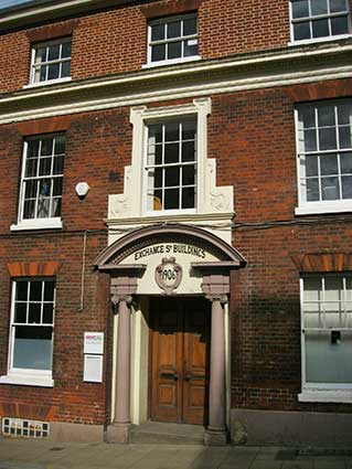
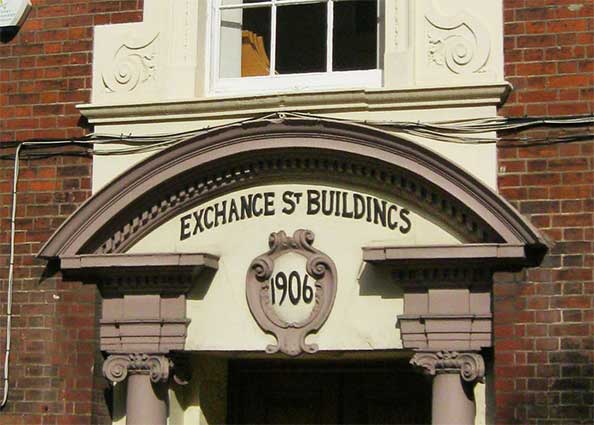
35-37 Exchange Street:
‘EXCHANGE ST BUILDINGS, 1906’ (beside entrance to School
Lane, see 50-52). Listed Grade II: ‘Early C19 with 1906 doorcase. Red
brick with rendered detail. Roof not visible. 3 storeys. 4 bays.
Right-hand off-centre recessed door with attached Corinthian [sic: surely they're Ionic
capitals?] columns
supporting open segmental pediment. Scrolled and eared window surround
above door. Sash windows throughout with glazing bars except in ground
floor bottom sashes. Egg and dart stringcourse between first and second
floors. Box cornice.’
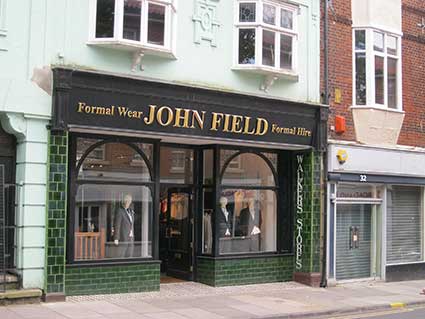
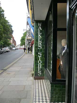
30 St Benedicts Street:
'WALKERS STORES'. The name in white characters on bottle green
background is shown vertically in ceramic tiling shop surround to the
left and the right. What did Walkers Stores originally
sell? It has the look of a grocery shop.
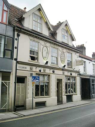
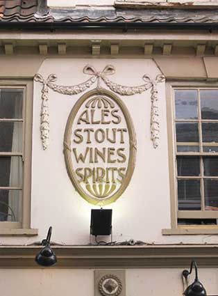
58 St Benedicts Street: The
Plough and Little Plough Yard. Two decorative ovals in the stucco at
first floor level carry a depiction of a hand-plough and ‘ALES STOUT
WINE SPIRITS’. ‘LITTLE PLOUGH YARD’ is signed above a passage entrance
to the left.
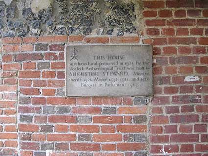
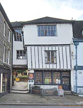
14 Tombland: the plaque
reads ‘THIS HOUSE purchased and preserved in 1924 by the Norfolk
Archaeological Trust was built AUGUSTINE STEWARD, Mercer, Sheriff 1526,
Mayor 1534,1546 and 1556, Burgess in Parliament 1547.’ On an excellent
example of a Tudor merchant’s house, the rear accessed via ‘TOMBLAND
ALLEY’ (signed above the entrance). On a corner stone above this entry
is the date ‘1549’ and Steward's merchant's mark, along with the
mercer's gild insignia. The movements in the timber-framed building
over time have resulted in some squeezed and skewed windows at second
storey level – it must be difficult to fit repalcement glass panes.
The name 'Tombland' sounds as
if it is derived from some long-lost
burial ground, situated as it is near the gates to the Norman
Cathedral, with the medieval Church of St Michael – the largest in
Norwich. However, the name comes from two Old English words meaning
'open ground', or an empty space. This open ground was used as the main
market place for Norwich; the hub of commercial activity and town life;
also for fairs. The rhythms of markets and fairs in the calendar were
of economic, social – and sometimes political – importance to
inhabitants and visitors alike.
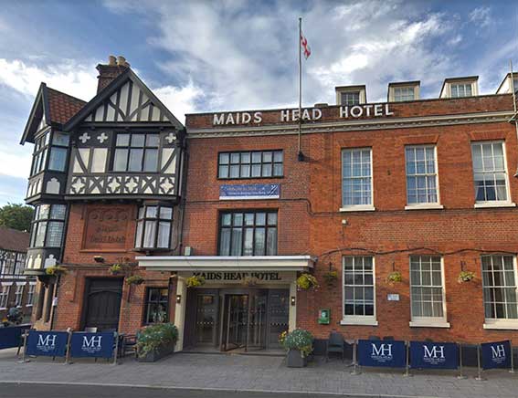
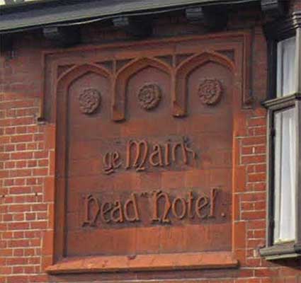
20 Tombland: The Maids
Head Hotel. The hotel dates from the 13th century and is
amalgamation of at least six buildings. The main façade faces on to the
intersection of three streets, Tombland (see the derivation above),
Wensum Street (named after the local river) and Palace Street
(presumably because in this area was the palace of the Earl of East
Anglia). The Maids Head Bar features Jacobean Oak panelling and has
been reputedly, frequented by guests such as Horatio Nelson and Edith
Cavell. Queen Elizabeth I was said to have slept at the hotel in 1587.
The large terra cotta panel features three gothic arches with Tudor
roses and the somewhat eccentric lettering: 'ye Maid's Head Hotel.' in
a version of medieval script; the damage to the "d's" bears comparison
with the name plaque of 'St Mary’s Croft', 13 Chapel
Field North (shown above).
Listed Grade II: ‘Former uses unknown, now hotel. C15 cellars.
C16 onwards with major facade alteration in the early C20. Red brick.
Rendered. Timber-frame. Pantiles and plain tiles. The complex is an
amalgamation of at least 6 buildings, Tombland facade:- 2 storeys, 3
storeys to the left, 4 bays extended to the left by 2 bays plus comer
bays. Central C20 4-door hotel entrance with flat hood. Door at extreme
right with round arch and attached columns supporting an open pediment.
4 steps up. Sash windows in right-hand 4 bays with glazing bars and
rubbed brick flat arches. C20 casement windows above central entry.
Paired bracket cornice below parapet. 4 flat-roof dormers. 3-storied
early C20 bay and corner bay extending into Wensum Street:- Door with
moulded timber surround. Casement windows throughout, corner and right-
side oriels with gables above. The top floor has pseudo-timber framing.
3 builds in Wensum Street:- 2 and 3-storeys, jetties and carriage entry
to the north of the middle range.’
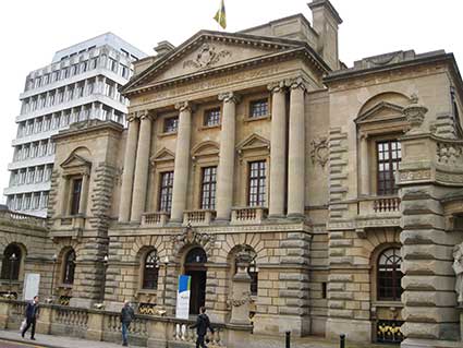
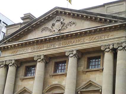
8 Surrey Street: ‘NORWICH
UNION LIFE INSURANCE SOCIETY’ sits in relief on the cornice of the
Palladian facade of a grand
stone palace of insurance, now called Aviva (the rename Norwich Union).
The company's offices in Surrey Street, known as ‘Bignold House’ (named
after Thomas Bignold, founder of the company), were built as a private
house for the Patteson family. Rooms in the house were heated by
fireplaces, some of which were designed by Sir John Soane, and clerks
were expected to bring in a pound of coal for each day
they worked during cold periods. If, during the course of the day, they
felt chilly, despite having provided the fuel, they were not allowed to
tend the fire, or indeed warm themselves. If they did so, they were
fined. This draconian rule, reminiscent of Ebeneezer Scrooge and Bob
Cratchit, was later relaxed and employees were allowed
to warm themselves, but only one at a time, and they still weren't
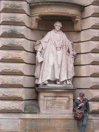
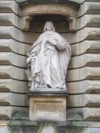
allowed to tend the fire. Near life-size statues stand in niches on the
pavement level of: ‘Rt. Revd. Willaim Talbot DD, Bishop of Oxford, a
founder of the Amicable Society’ and ‘Sir Samuel Bignold Kt., Secretary
Norwich Union Life Office, 1815-1875.’
Notes
There are about 1,500 listed buildings in Norwich:
60 are Listed Grade I,
127 are Listed Grade II*.
There are 31 medieval churches (more than Ipswich, York and Bristol put
together); Norwich is said to have more standing medieval churches than
any city north of the Alps.
Just for comparison, in April 2016 Ipswich had about 711 Listed
buildings:-
11 Listed Grade I,
23 Listed Grade II*,
677 Listed Grade II.
Ipswich has twelve medieval churches in the town centre (13 within the
Borough boundary, including the Church of St Mary & St Botolph in
Whitton).
Home
Please email any comments and contributions by clicking here.
Search Ipswich
Historic Lettering
©2004 Copyright
throughout the Ipswich
Historic Lettering site: Borin Van Loon
No reproduction of text or images without express written permission

 2013 images


