Bishops Hill /
Upland
Gate, Mitre Way, The White Elm, Rosehill Crescent
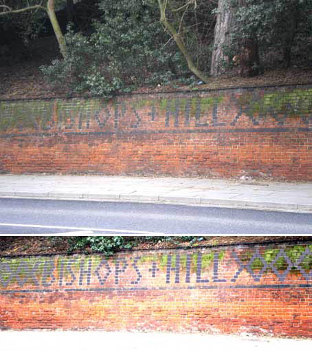
The wall with a
built-in road sign
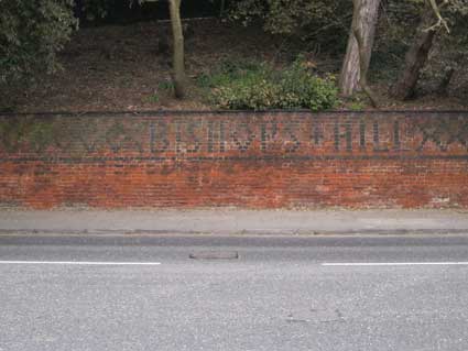
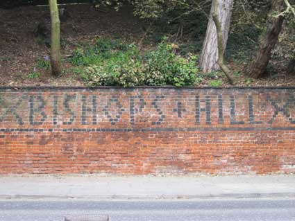
Leaving the town centre from the Duke Street junction,
Fore Hamlet starts to rise quite steeply. The retaining
wall to the left of the road (pictured below) holds back the raised
gardens as one reaches the top of Bishops Hill (just before it becomes
Felixstowe
Road). This area was clearly a desirable spot, sitting opposite the
corner
entrance of Hollywells Park and looking over the docks and Orwell
basin. The ancient
hub
of the old town has been described as dish-shaped around the entrance
made
by the great Orwell river. The combination of deep clays and green
sands
results in water percolating up from springs, filtered and cleaned and
being
unable to soak back through layers of clay. The springs used to flow
freely
down the sloping streets towards the Wet Dock (hence Spring Road -
the surrounding
streets still witness natural flows of water under brick walls and
through
tarmac, The Wash – Upper & Lower Orwell Streets– and Stepples
Street. – now Orwell Place).
 2014 image
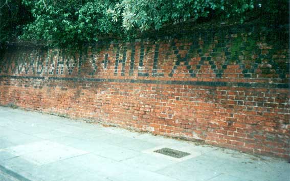
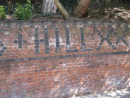
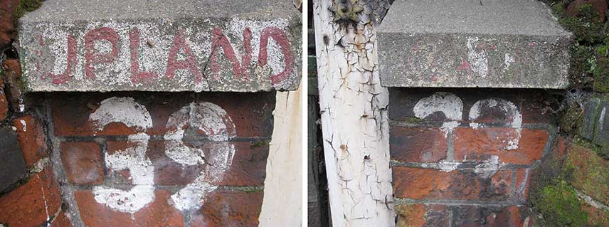
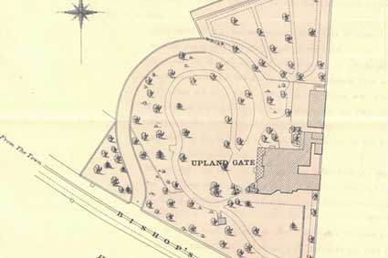
There is a large house and garden behind and above the
two-colour brickwork wall
shown. The house is accessed by a looping, sloping drive below the
lettering labelled '39, UPLAND ... GATE'. This seemed a rather
arbitrary
name, but it does appear on an 1883 OS map of the area. This
road
is now inflicted with fast moving traffic; it is doubtful whether many
passers-by
notice the lettering. The long diamond patterning in the brick
(diaper-work)
stretching up this
ancient
wall suddenly becomes:
'BISHOPS+HILL'
though shaded by overgrowing ivy
when originally photographed in March 2001:
 2001 image
This has since been trimmed, making the
lettering
more noticeable.
 2014 images
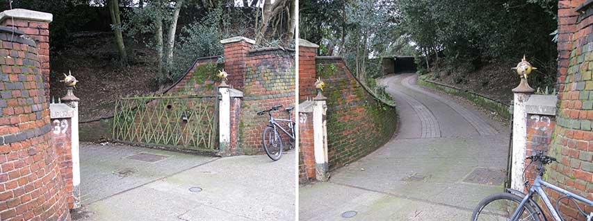
The Bishops Hill brickwork is Listed Grade II:
"Boundary wall, gatepiers and gate. c1863. By Hine and Evans for CA
Biddell, director of Ransomes of Ipswich. Red brick with burnt brick
diaper work. Iron and wood gatepiers and iron gate. Battered retaining
wall approx. 2 metres high with a deep frieze and diaper work in burnt
headers along the entire length to Bishops Hill which name it also
incorporates in burnt headers. Single large iron gate to entrance drive
is filled with lattice work and is supported on slim piers with spiked
metal ball finials. Forms a group with Upland Gate (qv). "
Now, 'q.v.' means 'which see', until 2019, we hadn't been able to find
a
Listing text for Upland Gate itself (scroll down)...
The gate
 2018 image
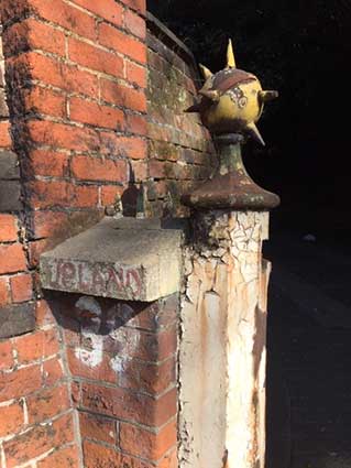
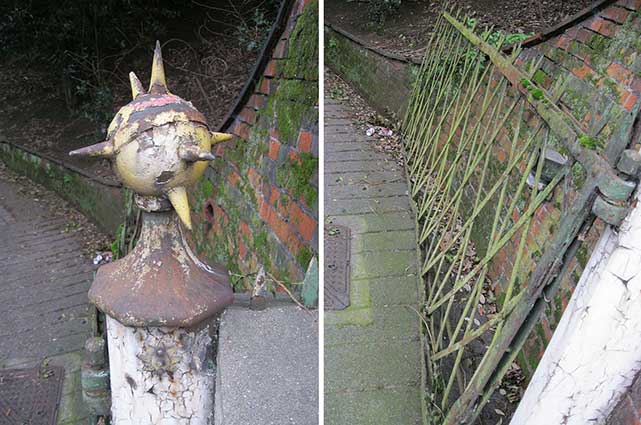
Above: the left-hand gatepost with hand-lettering 'UPLAND' on the edge
of the coping and a rather brutal '39' in whitewash beneath. It would
be good to sympathetically clean the brickwork and restore the spiked
ball finials.
 2016 images
It's interesting that the Nottingham architects who designed the
house have the attribution for the gates. It seems logical that Biddell
would have commissioned their manufacture, from the Hine & Evans design plans, in cast and
wrought iron from his own foundry at Ransomes Sims & Jefferies'
Orwell Works sited below the house on Orwell Quay (formerly Ransomes
Quay).
Below is a photograph of the wall in 2010: the
overhanging shrubs have almost gone, but the algae on the upper
brickwork makes legibility difficult. The enhancement below makes
things a bit clearer.
 2010 image
However, it was not always thus. The postcard from
about 1905 (below)
shows that Bishops Hill was considerably narrower then with no
pavement
on the side which concerns us here. The tram makes its way up the
centre
of the incline towards its terminus at The Royal Oak public house,
Felixstowe Road at
the
junction with Derby Road, while dog-carts and horse traffic fit into
the
spaces at the sides. The 1921 widening may have involved demolition of
the
retaining wall and a decorative rebuild avec lettering involving some
loss
of gardens to the properties. However, despite the fact that the
brickwork diaper pattern and lettering don't appear to be visible on
this image, it is not conclusive that the wall was not original.
Perhaps it is more likely that the left-hand side of the road was
pushed back. The Listing text shown above clearly states the date of
the wall as c.1863.
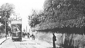 c.1905
More on the history of Ipswich
tramways.
'Uplands' [No wonder we couldn't find the Listing
when searching for 'Upland Gate'.]
'TM 14 SE BISHOPS HILL (North side)
642/12/10078 No.39, Upland gate 11.02.2000 II
House. 1863 by Hine & Evans for CA Biddell, director of Ransomes of
Ipswich. Red brick laid in Flemish bond, with snapped headers creating
cavity walls; slate roofs. EXTERIOR: 2 storeys, north front is 3-
window range. Central half-glazed door with one 1/1 unhorned sash right
and left. String course at first floor. Central arched staircase window
with margin glazing; twin 1/1 unhorned sashes to the right and one 3/3
unhorned sash to the left. All openings except staircase window with
artificial stone lintels and sills. Cornice with banding of burnt
headers. Twin hipped roofs. West front with canted b[a]y to right on
both storeys, and a projecting bay to left. Between them is a c1870
conservatory with cast-iron standards and brackets, and a cast-iron
balustrade. C1880 timber extension to left. First floor with central
French windows to balcony, one 2/2 unhorned to canted bay and a similar
arched window to projecting bay, with timbered hood. Datestone above:
1863 CAB. South front with full-height canted bay to left, with
alternate facets fitted with 2/2 unhorned sashes to first floor and 1/1
unhorned sashed to ground floor. Projecting bay to right with
ground-floor Venetian window, with columns terminating in daisy
capitals. First-floor string course, and an arched 2/2 unhorned sash to
first floor. Stack to south front, 2 stacks on north east plane and a
transverse ridge stack to west front. INTERIOR: main entrance to west,
through doorway arranged as a Venetian window, with columns with daisy
capitals. 6-panelled pine door. Entrance hall and staircase hall retain
original coloured encaustic tiles to floor. Open-string staircase with
turned balusters and ramped and weathered handrail. 6-panelled doors
throughout ground floor, with door furniture intact. Half-glazed
doorway to rear (north) lobby. Octagonal drawing room at south-west.
Marble chimneypiece with consoles below mantelshelf. Bell pulls right
and left in working order. Plaster vine trail to cornice. Venetian
window to south with panelled rising shutters. Brass picture rails.
Arched display alcove in north-east facet of room. Square dining room
to east. Marble chimneypiece with scrolled consoles below mantelshelf,
arched register insert, and bell-pulls right and left. Window with
panelled side shutters and exposed sash weights hung on external
pulleys. Larder, storeroom and kitchen with shelving and cupboards.
Tiled scullery east of kitchen. Back lobby with wash basin and toilet
at west end, with enclosed cistern and sanitary ware. Staircase window
with sash weights exposed, in form of cast-iron stacking bobbins. First
floor rooms with 4-panelled doors. Toilet with fittings dated 1907.'
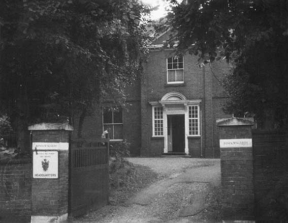
Above: the Listing text for the house (first listed in 2000) which
appears to be called 'Uplands' here, but then calls it: 'No.39,
Upland gate'.
Apparently, there is a 'Datestone above: 1863 CAB' on an
original timber extension
to the house. 'CAB' stands for the first owner: C.A. Biddell of
Ransomes Sims & Jefferies heavy engineering company, then based
below
the house at the Orwell Works. The datestone confirms the date of
completion of the house and grounds: 1863.
 1900s
map
1900s
map
Above: site map of the house and grounds, clearly showing the tramway
up the centre of Bishops Hill, so it may have been drawn in the early
1900s, after electrification.
A tangled web of speculative mapping
and odd naming…
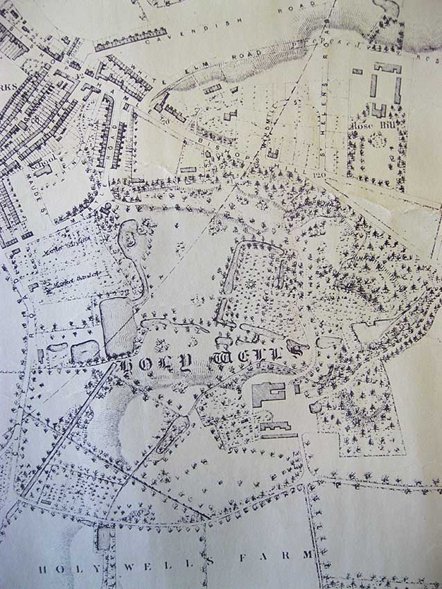
Below: a detail from Edward White's 1867 map
shows Bishops Hill and the gothic lettering of 'Holy Wells' over the
parkland. For a larger detail from the
same map, see our Cavendish Street
page.
1. It shows that Fore Hamlet
was called '[Wykes] Bishops Hamlet' at
this time, running into Bishops Hill.
2. Wykes
Bishop Street itself
appears at the top left as a side-road from Wykes
Bishops Hamlet, running
parallel with Albion Street. Wykes Bishop Street is now, of course, a
mere stump of a
street off Duke Street.
3. Here Wykes
Bishop Street delineates the south-western boundary
of Ransomes Orwell Works (you can just see the 'RKS' legend at the
upper left of this map detail), showing the relative proximity of Mr
Biddell's 1863 house, 'Uplands' up the hill from it (although it
doesn't appear to
be delineated particularly accurately on the map).
4. To the east is
'Windmill Street' curving off Wykes Bishop Hamlet,
later part of Rosehill Road and even later Rosehill
Cresent.
5. The road up the hill, which
today we know as Rosehill Road is
here labelled 'St Helens Road' – when the Rev. Nottidge built his
Trinity Vicarage here in the following year, it was called 'Vicarage
Road' (see our Rosehill case study
page) –with speculative extension to a junction to an even more
speculative extended 'White
Elm Road'. Given the very steep hills here (indicated by contour lines
on the map), it would have been surprising if this had ever been
achieved.
6. Eventually, of course,
Rosehill Road went north from the top
of Bishops Hill, then curved eastwards around the top of the steep hill
(the houses here have steep alleyways down from the road with even
steeper gardens behind), thence to cross Allen Road, and onward to meet
the southern end of Tomline Road and Derby Road.
7. The house marked here as
'Rose Hill' (later
Rosehill House) which gave the area its name, is shown in almost
solitary splendour at the upper right. South of it (beneath the large
word 'Well') we see the Cobbold's
Holywells House in its extensive parkland, later Holywells Park.
8. At the far left we see that
today's Holywells Road was in 1867 labelled 'Cliff Road' – a name now
given to the road which links Patteson Road with Cliff Quay.
 1867
map
1867
map
'Uplands', 39 Bishops Hill and
Bishopsgarth, Rosehill Crescent
"On the
subject of views across town, ... we looked
at the big house that's hidden on the left as you go up Bishops Hill.
It's listed but was in a real state (hence the asking price that we
could afford). The house was being sold by an elderly twin, his brother
had died and they had lived there as recluses since birth. The place
was tatty, but it was a beautiful example of Georgian architecture,
loads of great detailing and original fittings that hadn't really ever
been touched, particularly the shutters in the dining room - quite
something. Anyway the view from the garden across the town was stunning
taking in the docks and the whole of the centre of the town. We didn't
buy it in the end as we could afford the house on its own but would
have had to forego food and water for a few years after (to carry out
renovations).
(The house has) listed status, I seem to recall the council were
involved at the time and the owners wanting to ensure the house was
only sold to people with the money to restore it. If I were you I'd
wander up that driveway and knock on the door. To add a further twist,
the remaining twin knew my late Grandfather (well, my Mum's, Mum's
second husband who was always our Grandpa as far as we were aware) Noel
Turner who was partner in Garrod, Turner & Son, Fine Art
Auctioneers, he was involved in the collection of paintings by Suffolk
artists they had up there, it was all on the wall when we looked
round..."
Our thanks to Justin Kibble for this
account.
This rather raw detail from the 1930 map of Ipswich shows Bishops Hill and,
left of centre that curling drive leading uphill to Upland Gate (marked
in blue). It is clear that in 1930 another large house (marked in red)
stood near to the corner of Bishops Hill and Rosehill Crescent – the
site of today's Bishopsgarth flats. Also clear is the north-south
boundary which includes the eastern Upland Gate house wall which
divides the land from the corner plot.
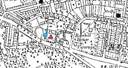 1930 map detail
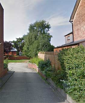
This boundary still exists and can be traced on the
aerial view shown above. It is visible from Rosehill Crescent between
the Bishop's Garth flats and number 3 (below). The Upland Gate roof
level shows the steep drop in the land on Bishops Hill.
 View from
Rosehill Crescent
View from
Rosehill Crescent
 2021
image
2021
image
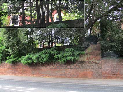
Above: the house can be glimpsed from the top end of the diaper walling
(see the close-up at top); the Bishops Garth flats are behind the trees
to the right.
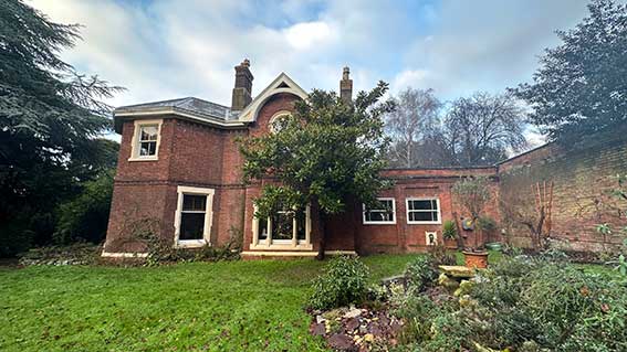
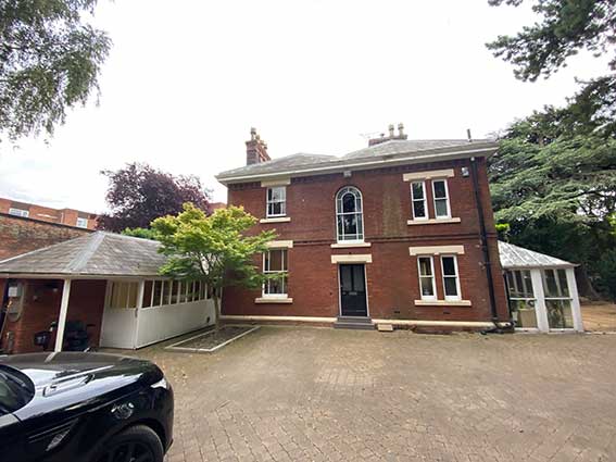
[UPDATE
20.3.2025: Dan R has sent these photographs of the exterior of Upland
Gate; he and his family have owned the property since 2021. Our thanks
to him]
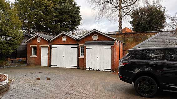
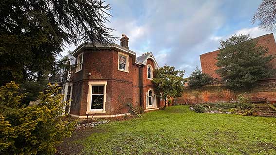 2025 images
Bishopsgarth, 1 Rosehill
Crescent
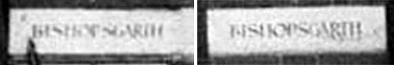
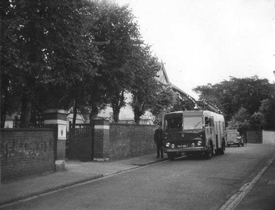
Thanks to the photograph, below from the collection of John
Harvey we can finally see Bishopsgarth, the house, through the original
gateposts. Rather a fine house it looks, too. The close-ups reveal that
the name of the house (picked out on stone pads on both brickwork
posts) as 'BISHOPSGARTH' – all one word. Also that the house acted as
the headquarters of the Suffolk & Ipswich Fire Service up to 1964:
the date of the photograph. The new Birkin Haward-designed headquarters
building on the Fire Service site on Colchester Road replaced these
offices in December 1964. John tells us that the next occupants of
Bishopsgarth were the Water Board. (Incidentally, work began to
demolish Colchester Road Fire Station
to make
way for housing in July 2012, having closed in the previous October,
when new premises were opened on Ransomes Europark). Looking at the
walling
and brick pillars on Rosehill Crescent today, it seems clear that the
original capstones were removed, the heights of walls and posts reduced
(removing the lettered stone pads) and the capstones replaced. The rise
in the ground from the entrance is today replaced by steps up to the
flats.
1964
images courtesy John Harvey – now part of the Ipswich Society Image
Archive
Below: a comparative 21st century photograph:
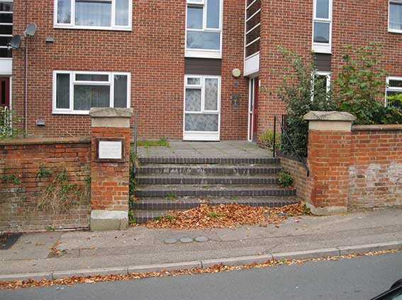 2017 image
The framed notice to the left, in a similar position to the Fire
Headquarters sign, reads:
'BISHOPSGARTH
1 ROSEHILL CRESCENT
FLATS 1 TO 15'
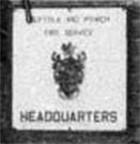
'SUFFOLK AND IPSWICH
FIRE SERVICE
HEADQUARTERS'
Suffolk Fire and Rescue Service is the statutory fire and rescue
service covering Suffolk. It was formed in 1948 as the Suffolk &
Ipswich Fire Service, before changing after the 1974 Local Government
Review to 'Suffolk Fire Service'. Following the 2004 Fire & Rescue
Services Act, the service name was changed to Suffolk Fire & Rescue
Service to better reflect its role.
Below: Rosehill Crescent, uphill from the Bishops Hill junction,
the right-angled bend towards Montrose at the right. The short
Victorian terrace of houses (3-5 Rosehill Crescent) can be seen above
the foliage. The gable (apparently 'timbered' in 1964) is above number
3.
1964
images courtesy John Harvey – now part of the Ipswich Society Image
Archive
Below: the view in the 21st century; the
manhole
cover in the right-hand pavement is still in position opposite the
Bishopsgarth entrance. The small window in the side wall of the first
house in the terrace, number 3, which is visible through the trees in
the 1964 photograph is present and visible (though obscured in this
photograph) today.
Life in Rosehill Crescent in the
1950s and 1960s
[UPDATE
1.7.202: ‘I have been reading with fascination about the area around
Bishops Hill. I lived in Rose Hill Crescent from about 1950 ’til the
late 1960s and my parents continued to live there (at no 7) until well
into the 2000s.
The large house – number one – was known to
us as the Auxiliary Fire
Service. I never remember any fire engines etc. there. It appeared to
be offices only.
The Montrose was a day nursery when I lived there and, most weekdays,
an army of nurses would walk their charges in massive
perambulators with toddlers in tow, down Rose Hill Crescent (three
separate words in those days) and across Bishops Hill to Holywells
Park. The Matron lived in a flat on the top floor. The Crescent was
lined with lime trees, clipped to within an inch of their life every
year. Every evening, a man with a bike and a long ladder arrived to
light the
three gas lamps and each morning he returned to extinguish them.
He would climb his ladder to light the lamps, but I believe in the
mornings he just had to pull a little chain to put out the flame. In
the early days the road was made of orange coloured gravel, and had a
really high camber in the middle.
From a bedroom window at the back of the house could be seen the
traffic on London Road, near where Thompson and Morgan’s was then
[Crane Hill]. Over the fence at the side of number seven was a garden
which I loved to look at. It was the kitchen garden for the Montrose
nursery and was immaculately laid out complete with a gardener and a
glass house. The neighbours at number five were Mr and Mrs Norman.
Mr Norman was a 'chemist' and his shop was half way up Bishops Hill on
the right hand side going up.
Tradesmen were a-plenty and the bread delivery came with a woman in a
little van. She came down the side passage with an enormous basket and
my mother would choose a loaf. The coalman also came along the passage,
and half-way along was a metal round cover which he would open and pour
the bags of coal down – straight into our cellar. Clouds of dust!! The
only fishmonger I remember was the seller of sweet shrimps by the pint,
on his bike with a large basket at the front, just at certain times of
the year. There was a grocer’s van too: red with a white horse, from
the Co-op. The dustbin man used to run down the side passage and down
the garden to the bin. It went on his shoulder and would be emptied and
then he ran back with it empty. There were about six men on the truck.
There was never much rubbish, and it was really mostly dust, or
actually ash, from the fire. Anything else, my mother wrapped well in
old newspaper, and scraps went to the chickens. I was always terrified
by the pair of horses which came with coal for the town. I think it was
Isaac Lord’s, from the yard next to Derby Road railway station, and two
heavy horses pulled the loaded dray down Rose Hill Road, then Rose Hill
Crescent, then turned right on to Bishops Hill. Just before turning
onto Bishops Hill, they would stop and the driver would place a couple
of large wooden wedges behind the wheels before encountering the hill –
this acted as brakes!
The buses on Bishops Hill were trolley buses. Number four went straight
on along the Felixstowe Road, but numbers 2a and 2b had to turn right
onto Nacton Road. For this turning the trolley would stop and the
conductor had to alight and with a long-handled piece of equipment,
would change the points of the overhead power lines. On the junction
was a great big trough of water for the horses, but I don't ever
remember seeing it used or filled.
I hope you will be able to use some of this information. Happy
memories. Yours, Ruth Fisher.’ Many
thanks to Ruth for such detailed recollections. She has confirmed that the small wooden
shop still seen half-way up Bishops Hill is indeed Mr Tom Norman's
chemist's shop which she mentions.]
The
former chemist's shop run by Mr Norman,
who lived next door to Ruth Fisher in Rosehill
Crescent, can still be seen on Bishops Hill. The small driveway at left
runs up behind the row of 1930s houses on their ridge. The backs of the
houses on Myrtle Road can be seen to the right. The shop would have
stood almost opposite The White Elm public house. Scroll down for a
little more information about Montrose (under 'Researching the area')
and The White Elm.
The
Mason family
[UPDATE 25.10.2015: "I've been doing our family tree, and to
cut a long story short, I was looking for the house that my husband
remembered visiting as a child. It was Upland Gate and was owned by my
husband's Great Aunt Elsie Ellen (née Wheeler) Mason, who was married
to Henry Freeman Mason. Widowed, she lived there with two of her four
sons (all four boys grew up there). Two of the sons, Richard and Ivan
lived with Elsie and never married. Richard Mason went on to be an
artist. My husband remembers that Upland Gate was run down, overgrown,
dark, spooky (certainly to him as a child) and 'smelled funny'. There
were sculptures of various sorts dotted about the grounds and he found
the place somewhat unsettling, although his mother has fond memories of
visiting her aunt there.
Looking for images of the house, I found your article about the
lettering along the boundary wall and following the link. As I had only
just spoken about the house, I found it very interesting that your
contributors description and my husband's were so similar. Do you know
if the house still exists, or has it been demolished by the ever-grabby
land developers? Many thanks for preserving the local information, I
found it fascinating...
We live in Colchester, so I usually only visit Ipswich when shopping
with my daughter or going to the Regent. I should get up there more
often and have a wander around for fun. My husband (and his mother!!)
is the one with the local knowledge. His great grandfather, Henry
Ernest Wheeler (Elsie Ellen Wheeler mentioned earlier was one of his
daughters), ran a bakery at 28 Great Colman Street (now a Rio Brazil
café). His son, Godfrey (my husband's grandfather) delivered the bread
from the bakery to their customers. He grew up to become a skilled
confectioner and my mother-in-law vividly remembers being smacked for
taking one of her father's expensive chocolates from his shop when she
was about 5 years old (1929).
Here is a photograph of Elsie Ellen Wheeler later Mason. You have my
permission to include the contents of these emails on your Ipswich
page, we would be delighted to have helped preserve a little local
history. I had no idea when I moved here with my job many moons ago,
and met my husband in 2004, that half of my own family also lived half
an hour up the road!! I look forward to hearing any further news should
you uncover anything new. Kind
Regards, Nicola Tuffley" Many thanks to Nicola for the information
and particularly for the striking family portrait – we don't feature
people's faces on this website very often as we deal with structures,
objects, architecture, local history and so on. It is good to have a
glimpse of the 'real people' about whom Ipswich Historic Lettering is
really about.]
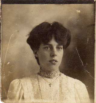 Photograph
courtesy Nicola Tuffley
Photograph
courtesy Nicola Tuffley
Elsie Ellen Wheeler (later Mason), born 1887. See
mention of Mrs Mason in the following update.
Why 'Bishops
Hill'?
The answer is given on our 'Ransomes' page,
suffice to say that there were four hamlets of Gipeswic
(spellings vary), the
ancient town: Wykes
Bishop, Wykes Ufford –
see our St Clement's Church page for a
passage on
this by G.R. Clarke – Stoke
and Brookes.
Wykes Bishop, or 'Bishop's
Wick' stretched from Bishop's Hill down to the river. The
moated residence of the Bishop of Norwich stood in Holywells Park from
1235 until the dissolution of Catholic institutions by Henry VIII,
1536-1541. You can still see parts of the moat around the children's
play area. On the early 1930s map below it is the near-complete
rectangular moat.
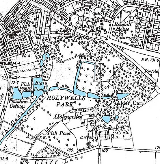 Early 1930s
map
Early 1930s
map
As so often in Ipswich, the hills around the Orwell river basin sprout
with spring water. The map indicates the bodies of water in Holywells
when the mansion still stood. The sequence of ponds down the hillside
(famously painted by Gainsborough) can be seen, some forming part of
the remnants of the moat round the Bishop's Palace, descending to the
'Big Pond' which can still be found, which then feeds 'The Canal',
which was dug to supply water under Holywells Road and into the Cobbold
Brewery on Cliff Quay. See also our page on Water
in Ipswich. Incidentally, the 'Pinfold' seen on Nacton Road at
middle-right of the map is a pound, or enclosure for impounding stray
stock animals.
A footnote to the big houses here on the high ground
overlooking what was, in the 19th century, the poorest part of Ipswich:
St Clement's parish:-
"Overlooking the densely populated dockside area though hidden from
view, were the houses of some important townsmen. Most notably, at the
top of Bishop's Hill stood Holywells, the residence and park of the
Cobbolds, the dominant ground landlord of the district below, the owner
of the Cliff Brewery and a
considerable employer of labour. Also at the
top of the hill there were a number of new houses of men of some
substance in the town's affairs including a mechanical engineer,
Biddell [C.A. Biddell, director of Ransomes], at Upland Gate,
Thomas
Mortimer, a merchant and Rev.
Francis Maude, the Vicar of Holy
Trinity Church. At the top of Back
Hamlet was Hill House and its
grounds, the residence of the Byles
family, malsters and merchants, and just below was Trinity Lodge, where
the vicar of St Lawrence lived. Such residences away from and literally
above the masses in the streets below and unlike those of their fellows
who still lived in Fore Street and Church Street [later Grimwade
Street], were part of that process of spatial distancing that was
taking place in Ipswich as in most large towns as in nineteenth-century
class society became more clearly differentiated. This separation of
the classes is also apparent within the area as well: behind the mainly
middle and lower middle class thoroughfares of Fore Street, Church
Street and Borough Road [both now parts of Grimwade Street] lay the
warren of poor housing where the mass
of the labouring poor lived." Extract from Rags and Bones by Frank Grace see Reading List.
[UPDATE 17.12.2015: "After
living in Australia since 1965 I was fascinated to read information
regarding Bishops Hill, where I lived with my mother and sister for a
couple of years (1962-65).
We actually lived next door to Mrs Mason's property (on the lower
side) in what we used to believe was known as The White House (still
standing). My mother had bought the smaller (western) half of the house
while the other half had been divided into flats.
As an 8 or 9 year-old I remember visiting the elderly lady (and the
name Mrs Mason seems to ring a bell [see
the entry and photograph above concerning Mrs Mason])
in the large house next door
on only one occasion. And of course I also remember the letters on the
roadside wall as I walked past them on my way to and from Cliff Lane
Primary School via Holywells Park.
However my immediate interest is in the history of the land on the
lower side of The White House (now occupied by Mitre Way and its
buildings). When I was young there was a significantly lower vacant
block that separated our house from a pub that stood about where the
new road is now. The pub was owned/managed by a family named
Hetherington and to my knowledge was called something like 'The White
Horse/Bull'. It was rumoured (perhaps only among us kids) to have had
false walls and secret tunnels dating back to times of smuggling.
The vacant block (which also extended through to border Cavendish St)
looked like it had once had buildings on it. To the north of the vacant
block there was a huge metal fence (which we once scaled) and behind it
was what seemed to be a swampy, densly treed unspoilt area that
contained turtles and seemed completely mystical to us young children.
I was wondering if you or any of your readers know the history of The
White House, the pub, or the vacant land that used to be in between and
at the back of them. Steve Jarron."
Researching the area
We have produced some research in response to Steve's original email.
One aspect is Montrose (House) in Rosehill Road which in the 1980s was
Suffolk County Council’s Montrose Day Nursery. Montrose had large
gardens and steeply sloping woodland before all the new housing
arrived, accessed from Rosehill Crescent and Mitre Way in the 1990s.
 2021 images
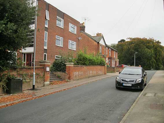
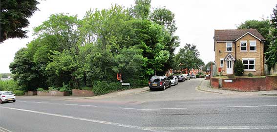
Above: the entry to Mitre Way from Bishops Hill in a
composite photograph with, to the left, the pocket park which is the
presumed site of The White Elm public house.
At the bottom of the slope, there is a kind of trapezium leading
off
and back onto Cavendish Street, White Elm Street. In truth, this is
only a made-up road on the two sides, one with industrial structures
and one with a handful of houses with the joining bit being an
overgrown track. It is named after the pub Steve mentions, The White
Elm.
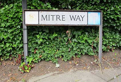
Mitre – a Bishops' official headgear – was an obvious choice as the
name for a new offshoot from Bishops Hill.
The White Elm
Pondering on the actual site of this pub,
the Suffolk
CAMRA
website (see Links) provides a remarkable,
grainy image from c.1960 showing it standing just below The White House
(nos. 35 and 37 Bishops Hill). It was just below the current Mitre Way:
today, a wooded seating area with a small play area behind. A rough
footpath below this spot leads down onto White Elm Street. The road in
the right foreground of the photograph must be Myrtle Road (it suffered
bombing during World War II), which is still there today, although the
Myrtle public house which stood further down Fore Hamlet closed in 1936.
From the details of the White Elm pub on the CAMRA website it had quite
extensive out-buildings and land (“yard, garden & orchard”).
Now, to the area of woodland behind was the steep wooded slope of the
land behind the formal garden of Montrose. The wooded bank can still be
seen from Cavendish Street. They cut through Mitre Way on part of this
and extended Rosehill Crescent down the hill to build a surprisingly
large number of dwellings. Montrose is now divided into flats
with a number of listed trees around it.
White Elm Inn, 23 Bishops Hill
(grid reference TM 174 438); closed March 18th, 1965 last owner
Tollemache. First publican listed: 1752.
Also reported at 141-143 Fore Hamlet (Bishops Hill address from
Ipswich licensing records).
Extra historical information [from Suffolk CAMRA site]
A reference in the Ipswich Journal on 11 Apr 1752 to Robert Baker at
the White Elm in Ipswich. The Ipswich Journal reported on Mar 13 1802:
To be sold by auction at The Bowling Green, Ipswich on Tuesday 23rd
March, 1802 at 7pm, All that good accustomed Inn, called The White Elm,
with the yard, garden & orchard thereto belonging, situate in the
parish of St Clement, Ipswich and now in the occupation of John EASTY,
or his undertenants.
A report in the Ipswich Journal in Nov 1855 states :
“To be sold by auction, by order of Mr George Bellamy, who is leaving
the White Elm, Ipswich, part of the excellent household furniture,
featherbeds and bedding, large willow dinner service, 33 dozen knives
and forks, 20 dozen mugs, 30 dozen of beer and liquor glasses, liquor
casks, spirit measures, tables, etc. To be let with immediate
possession, the well frequented public house , known as the White Elm,
having a large garden and saloon, a first class club holds its meetings
at the above Inn”
A report in the Ipswich Journal
in July 1890 states : “The estate of
the late Mr Owen Ridley, a brewer of Ipswich was submitted to public
competition on Wednesday 2nd July 1890 and includes the following
public house details: the White Elm, Bishop's Hill, let at Ł10 per
annum, with stables, 6 cottages, and land, let at Ł37 14s 6d per annum
(freehold)” eventually bought by the bid of Messrs. Tollemache. A
report in the Ipswich Journal on 27 May in 1893 states : “On Whit
Sunday, 1893, William Exworth married Caroline Elizabeth. daughter of
George MAYHEW of the White Elm Inn, Bishops Hill, Ipswich.”
Montrose, Rosehill Crescent
[from Ipswich Boro’ Local List]. 1905.
Architect: Eade and Johns. Large 3 storey detached house, in a mature
garden setting. Red brick, slate roof tiles. Rectangular ground plan,
hipped roof. The garden facing west elevation is symmetrical; 2 story
flat roofed bays at either end of the broad frontage, 3 window bays
between and a modern timber terrace (plastic panels in roof). Long flat
roofed dormer in roof slope above. South elevation has first floor
oriel window on timber corbels, open entrance vestibule below with
timber support columns on brick walls. Other elevations are more
informally grouped; extensions, dormers , chimney stacks and covered
porches.
And a follow-up from our Australian enquirer, Steve Jarron: "Thanks
immensely for the information you
have provided to me. It is prompting lost memories of my
childhood to come flooding back to me. It also explains some
of the 'mystery' about what was beyond the high metal fence at the rear
of the vacant block.
'The picture of the White Elm is fantastic. About once a week my mother
used to take my younger sister and I for a short walk down to where a
Fish & Chip van used to park in front of the pub and we would buy
great fish and chips. I seem to also recall that we could buy packets
of Smiths Crisps from the van. The interesting thing was that the
packets contained little blue waxpaper wrappers containing salt so that
you could use it to match your taste - an option we don't get nowadays.
There used to be a shop further down the road (on the other side) owned
by a bloke I think was called Teddy Wars (or something similar). My
sister and I would regularly go down there to buy sweets/lollies
including Tom Thumbs, Humbugs, etc from the large range of big jars he
had. As I said, I could go on for ages about life as a 8-9 year old on
Bishops Hill.
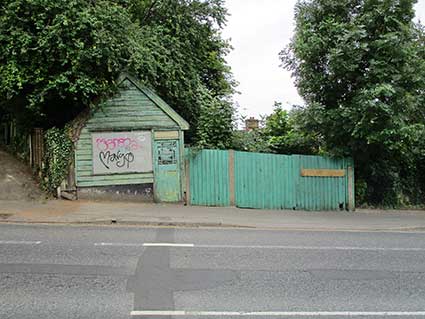 The sweet
shop in 2021
The sweet
shop in 2021
[UPDATE October 2025:
sadly, the tiny shop on Bishops Hill was subject to an arson attack in
mid-2025.]
In 2007 my wife (who had never been to England) and I were lucky
enough
to travel to England and Scotland for 4 weeks. I was able to share some
of my childhood adventures with her and took her to Bishops Hill,
Felixstowe, etc. We bought some fantastic fish and chips (further along
Felixstowe Road) and had them for lunch in Holywells
Park. It was an unexpected coincidence that the day we were there
was the opening day for the (then new) children's play area in the
park. Of course with many things still the same after more than four
decades, the area immediately down from The White House had changed
beyond recognition - hence my enquiry to you.
So thanks ever so much for your very enlightening (and extremely
prompt) response. I will continue to monitor your website with
interest. Steve Jarron" Many thanks to Steve for his interest and
enthusiasm.]
See also the Suffolk Mills Group document on Windmills
in the Borough of Ipswich
(click to open the PDF).
Home
Please email any comments and contributions by clicking here.
Search Ipswich
Historic Lettering
©2004 Copyright
throughout the Ipswich
Historic Lettering site: Borin Van Loon
No reproduction of text or images without express written permission