Tewkesbury, Gloucestershire (and environs)
Tewkesbury is an attractive, historic town dominated by
timber-framed buildings with overhanging eaves and has a fascinating
maze of small alleyways behind the main streets. It is situated on a
spit of gravel just above flood level at the junction of two great
rivers (The Severn and Avon) . The town has always been a favoured
resting place for travellers on the highway which winds it's way up the
Severn valley. Tewkesbury is remarkable in that its medieval layout and
character has survived to this day. At the beginning of the 19th
century it was one of the most important towns in the country but
suffered a decline and from 1850 to 1930 there was virtually no new
building in the town. As a result, the development of the town from
it's earliest days can be seen in it's street pattern and buildings. To
walk around it is a rewarding experience. Tewkesbury's famous Abbey was
founded at the end of the 11th Century as a Benedictine Monastery.
Alleys
A feature of Tewkesbury buildings is the wide continuous window at the
first floor level on a number of prominent properties, all which were
re-fronted in the mid 17th century. Other characteristic features of
Tewkesbury came with an expanding population in the late 17th and early
18th centuries. With building construction constrained by the flood
plain the height of buildings was raised and rows of cottages reached
by about 90 alleyways (although only 30 remain today); these alleys had
formerly served barns and workshops; later additional dwellings were
built behind existing houses fronting the streets. The poverty,
cholera, filth and overcrowding which afflicted the alleys in the 18th
and 19th centuries can only be imagined.
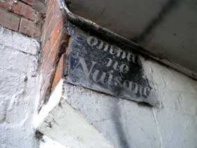
Eagles Alley leads off High Street. George Eagle ran a successful
butchery business in 1836 from the shop fronting the High Street. It
has an intriguing sign lettered on a sheet of black-painted metal fixed
up high near the 'ceiling' (now partially obscured by careless
whitewashing):
'Commit
no
Nuisance'
[We have found a similar sign
in St Albans. This
sign is in a polite code: Do not use this palce a s a toilet'. Although not illustrated
on this site, we learn of another 'Commit no nuisance' sign on the
wall of Christ Church Spitalfields in
east London – there is
more information on that page.
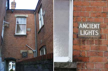
This imperative command contrasts with another, rather
mysterious, sign in this alley high up on the rear wall of the High
Street buildings:
'ANCIENT
LIGHTS'
In fact, in our
photograph you can just see that there are two identical signs by the
other windows in this building. The excellent Historic
window guide published by The Conservation Team at Tewkesbury Borough
Council (www.tewkesbury.gov.uk/media/pdf/7/8/Historic_Window_Guide.pdf)
defines the word 'lights' as: "the areas or compartments within a
window, framed by mullions, transoms, or glazing bars, through which
light is admitted". The right to light is a form of easement in English
law that gives a long-standing owner of a building with windows a right
to maintain the level of illumination. It is based on the Ancient
Lights law and the rights are most usually acquired under the
Prescription Act 1832. In the centre of London near Chinatown and
Covent Garden, particularly in back alleyways, signs saying "Ancient
Lights" can be seen marking individual windows. The design and
construction of the BBC's Broadcasting House in Portland Place, London
W1 was also affected by locals declaring their right to ancient lights.
It resulted in a unique asymmetrical sloped design that allowed for
sunlight to pass over the building to the residential quarters
eastwards, long since demolished and now home to the new Egton Wing.
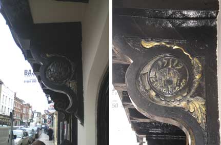
Back outside no. 12 High Street, Tewkesbury it's easy to miss:
'15...19
Ye Olde Fleece'
on the boss of the support for the jettied frontage,
with the date split by the vertical rope which suspends the unfortunate
ovine beast. The lettering and foliage surround is picked out in gold
on the dark wood/black background. This is just below the Bajee Indian
restaurant (sign partially visible in the image) and the former public
house is Grade II* listed (so many of the Tewkesbury town centre
buildings are listed). There is furthermore a carved circle containing
the date '1879' (?) on the front beam facing the street adjacent to
this '1519' boss. This may indicate that the original inn buiding was
refaced in the 19th century.
Rivers
The natural confluence of the River Severn and the River Avon has been
engineered over the centuries. At normal summer levels, the River Avon
is about 7 to 8 foot above the Old Avon and River Severn. Passage
between the Severn and Avon is facilitated by the Avon (or Tewkesbury)
Lock. Mill Avon is the name given to the canalised stretch of the Avon
which runs from the weir north of Tewkesbury past the Brewery and Flour
Mills (shown below), the Abbey Mill and weir and eventually into the
Severn to the south-west of the town.
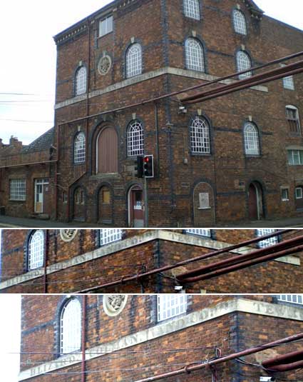
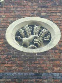
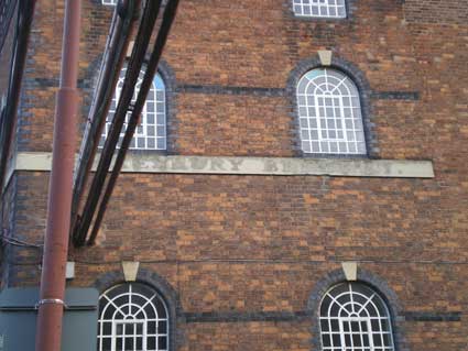
The former Blizard and Colman Brewery stands on the
corner of Quay Street and Back Of Avon. Brothers George and Walter
Blizard established the brewery when forming a partnership with William
Colman of Norwich. The business was acquired by the Wickwar-based
Arnold, Perrett & Co.Ltd. during 1893. A fine carved stone roundel
of a disembodied hand grasping ears of barley sits above the strip which runs just below the second
storey windows bearing the faint words:
'BLIZARD, COLMAN, AND CO.
... TEWKESBURY BREWERY.'
[last word barely readable]
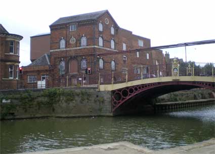
Just across the river is Healing's
Mill shown below empty and in the early
stages of dereliction. There are two huge mill buildings with massive
silos and various outbuildings. Once roaring with the sound of mill
machinery, it closed in December 2006 is now (2011) disused and slowly
gathering dust. The excellent serif'd lettering plaque is high up, but
clearly readable with the Roman numeral date much smaller:
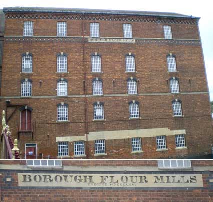
'BOROUGH FLOUR MILLS
ERECTED MDCCCLXV' (1865)
This is just one of the mill buildings and it has
serious structural faults, leaning at an odd angle, hence all the
reinforcements on the walls further down. Note also the carved date
very
high in the diamond dark brickwork: '1889':
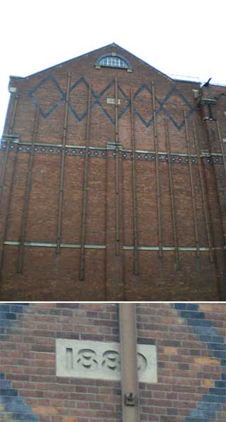
If you look at the waterline against the courses of bricks the tilt is
obvious, presumably due to insufficient foundations on the flood plain
of the rivers. Some modern silos make up part of the site. This more
modern mill (compared to the Abbey Mill downstream) stands on the site
of the
town quay; parts of the mill date to 1865 when it was built for Samuel
Healing and it was once thought to be the largest and most modern flour
mill in the world. The mill has, in the course of its history, had
three forms of transport in and out: road, railway (a victim of the
Beeching cuts) and canal/river barge. The original cast iron bridge
between the brewery and the flour mills has a second smaller iron
bridge built up against it; we hear that a railway ran into and out of
the flour mills and this extension to the bridge may have carried it.
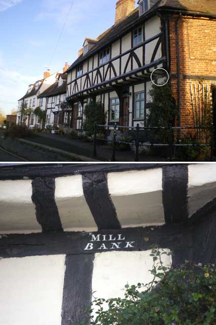
A little further down Mill Avon one finds the Abbey Mill, now
a residential building, with its weir. Nearby is the half-timbered rake
of houses
named:
'MILL
BANK'
in white characters on one of the dark painted
bresummer beams beneath the overhang (circled in the image below). A
venacular use of serif caps above and italic serif caps below.
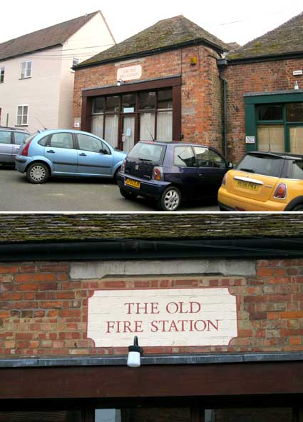
Wandering up the hill from Abbey Mill we find:
'THE OLD
FIRE STATION'
in red painted serif
caps on a cream cartouch with red outline. This is obviously a
relatively new sign, but the building is clearly old and the name
resonates.
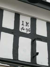
Further up the road, standing opposite the Abbey is the timber
framed The Bell Hotel, formerly known
as The Angel. Some parts of the fascia of The Bell look rather recent,
but on the first storey is the inscription:
'IK
1696'
'IK' is Jacob Kingsbury, presumably the original owner.
It is a fine example of a 17th century inn. Parts of it, e.g. the
cellar,
are believed to be even older. It is recorded that it was previously a
medieval hostel associated with pilgrims to the nearby abbey.
Old Baptist Chapel Court
One of the many Tewkesbury alleyways (in this
case opposite the school shown below) bears the shaped plaque above the
entrance:
'THIS COURT contains
an early Baptist Chapel the Home of the Baptist Church whose records
date from 1655. The building has furniture of that period. The Burial
Ground has the Tombs of the Shakespeare & other noted Families.'
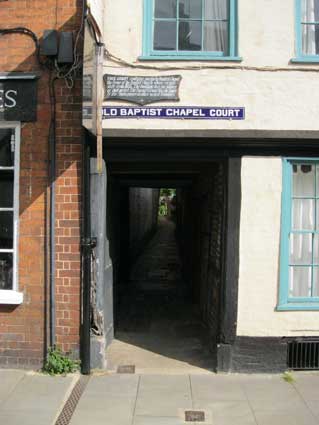
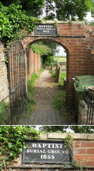
So it is that the clearly signed: 'OLD BAPTIST CHAPEL COURT' -
in enamelled white capitals on royal blue ground with a white border
line - takes us down past this historic building on the right and
eventually to an entrance arch bearing a cast iron sign with embossed
white caps on black ground:
'BAPTIST
BURIAL GROUND
1655'
[UPDATE
20.7.2024: We noticed an excellent, framed hand-drawn map by Project
Alleycat of the Tewkwsbury alleys and courts in the recently opened
Dobbies garden centre on the outskirts of the town. Below is an edited
image showing the large numbers of these passageways, most of them
running off High Street and Barton Street.Tewkesbury Museum publishes a
walk leaflet covering many of these.]

Church Street
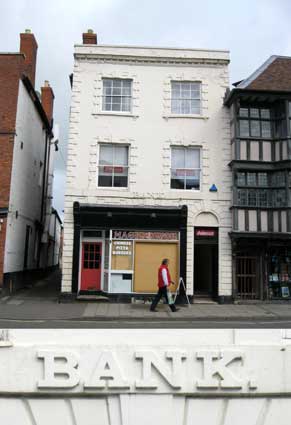
Further up Church Street we find the somewhat less distinguished Magic
Wok business (with its all-encompassing offer of 'Chinese Pizza
Burgers') with its relief lettering:
'BANK.'
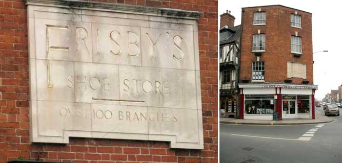
A few yards further along is The Cross
memorial which stands on a roundabout
at the meeting of three
roads. The panel on the first floor of the corner building of Barton
Street and High Street bears the words:
'FRISBY'S
SHOE STORE
OVER 100 BRANCHES'
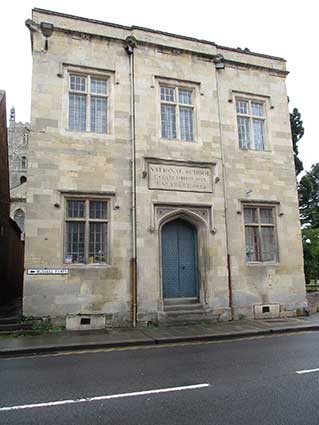
National
School, 51 Church Street
 2025 images
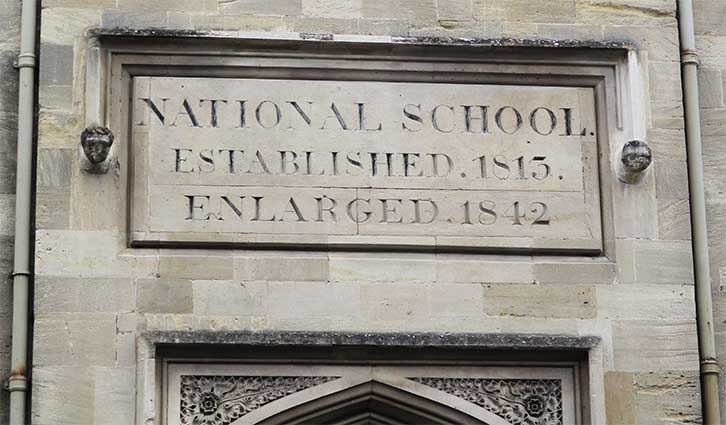
'NATIONAL SCHOOL.
ESTABLISHED. 1813.
ENLARGED. 1842'
The building is
Listed Grade II: 'Former school, now Abbey Office. Founded 1813, built
1817, enlarged 1842. Limestone ashlar, slate hipped roof behind
parapet. Tudor Gothic style. Lofty free-standing rectangular block in
two storeys, threexfour-windowed, all two-light stone recessed
chamfered-mullion and transom casements to flush surrounds under
stopped drip courses. Front to Church Street has centre bay slightly
brought forward, with pair of plank doors on four sandstone steps in
four-centred arch with stopped drip and decorative spandrels. Above
this is raised commemorative panel under stopped drip, inscribed:
NATIONAL SCHOOL FOUNDED 1813 ENLARGED 1842. Plinth, enriched coved
cornice with florets and two gargoyles, blocking course and saddle back
parapet. Side to Abbey Churchyard similar, no door; left return, to
alley, in rough coursed squared stone, five scattered windows without
enrichment. Far left is six-panel flush beaded door to segmental
voussoirs, on one sandstone step. Back partly concealed by
timber-framed 1842 extension has two windows visible at first floor.
HISTORICAL NOTE: the building is in part on the site of the former
detached belfry to the Abbey (demolished in 1816) and completed at a
cost of £345.8.3[?]. (Bennett: The
History of Tewkesbury, 1830) describes it as ".. a very neat and
substantial structure ..".'
You can glimpse the Abbey to the left of the building (above). The
national School In 1833, this school catered for 138 boys and 62 girls
(with an additional 11 boys and 10 girls on Sundays). National Schools
were set up from the early 19th century onwards and some continued in
use as schools until the mid-20th century. They were once a common
feature of our villages, towns and cities. They were often smallish
buildings (compared with modern school buildings) providing basic
facilities - perhaps only one or two classrooms.
Oldbury Road
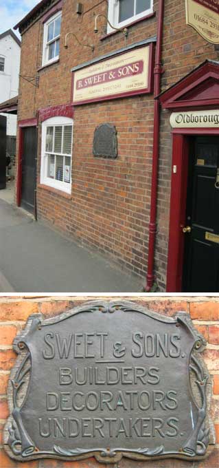
R. Sweet & Sons is still an up-and-running business in
Oldbury Road. The building bears an embossed metallic crest mounted on
a shaped wooden support:
'SWEET &
SONS
BUILDERS
DECORATORS
UNDERTAKERS'
This reflects the long
history of laying the dead to rest with either carpentry (coffin
manufacture) or masonry (tombstone carving).
People who like this website will probably like Tewkesbury
Museum (see Links), with its 'proper
old-fashioned' museum feel and layout.
Tewkesbury environs
In the village of Kemerton a few miles from Tewkesbury
we
find:
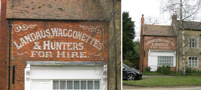
'LANDAUS.WAGGONETTES
& HUNTERS
FOR HIRE.'
We assume that the
apparent full stop after 'Landaus' is actually a worn comma. The
curlicues are a delight. This American-sounding vocabulary is a
surprise. A landau is a
coachbuilding term for a type of four-wheeled, convertible
carriage. A waggonette
is defined as a light four-wheeled horse-drawn vehicle with two
lengthwise seats facing each other behind a crosswise driver's seat. A hunter is, er... a carriage used in
hunting, naturally.
Related pages:
Cheltenham
Cirencester
Winchcombe (including Upton-On Severn)


