'Sunny
Place', Albion Mills, The Case Is Altered, Holme Wood
In June 2020, Jan Ordowski got in touch on a few matters. One
intriguing question sprang from an entry in Kelly's directory. 'I'm
particularly interested in the exact location of ... Sunny Place which
was near the Catholic Church on Woodbrige Rd & also mentioned in
Kelly's up to the 1970s.' In
looking into this tiny 'Place', we thought
that it would be of interest on this website in pointing up roads and
buildings which are built, disappear, are built over and (sometimes)
become something else: an ever-evolving town.
Kelly's entries
Jan sent images of two entries from Kelly's
directory from 1925 and from 1964-66.
The key line is '... from 326 Woodbridge road.'; also that there
were
only four addresses in Sunny Place. An audit of the surviving addresses
in this part of Ipswich has to take account of a major demolition
project and housing development, now known as "St Mary's" (see 'Home
Wood' below):-
Houses across from The Case Is Altered
(marked ‘P.H.’ on the 1902 map):
The house set back and beside the chapel is 320.
The double-fronted “nun’s house” is numbered 324(?).
[Entrance to St Marys Road]
The ‘eye-catcher’ house on the opposite corner to the Co-op is numbered
1 (St Marys Road).
334 to 342 (5 dwellings). The modern St Mary's Catholic Primary School
is built behind and around them.
1902 map
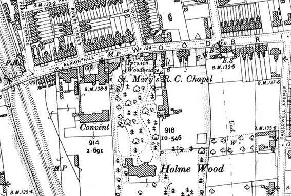 1902 map
The 1902 map detail has a number of interesting points. The entrance to
the gardens of Holme Wood stands opposite the site of today's Co-op.
The serpentine drive is echoed by the road and path in St Mary's
housing development. One assumes that the long building to the east of
the path is stables/carriage house; perhaps the house on Woodbridge
Road opposite Belvedere Road (and the site of today's Gothic
'eyecatcher') is a lodge house for Holme Wood. Why are the words
'Ipswich' and 'Woodbridge' bracketed just below the entrance on the map
– presumably something to do with the Catholic chapel? St Mary's
'School' labelled south of Albion Hill has four small cottages between
it and the railway cutting. The Victorian Catholic Primary School was
demolished in the 1980s and a new school of the same name built which
became part of the St Mary's housing development.
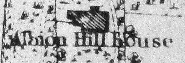
Albion Mills and Albion Hill
At the top left corner, running off Parade Terrace (later
Belvedere Road), is 'BACK OF ALBION MILL'. Edward
White's map of 1867 (detail below) shows the site of the two
windmills which stood atop the hill to catch the prevalent
south-westerlies here – hence the name of the public house on the
corner of Woodbridge Road and Belvedere Road: The Albion Mills (now
demolished). The pub sign is shown on our Parade
Field Terrace page. There is the legend 'P.H.' floating over the
railway relating to the tiny The Robin Hood & Little John public
house. Albion Mills, not labelled ran as a pub from the mid-19th
century and was closed in 1995 and demolished with neighbouring houses
on Woodbridge Road to become, respectively, Bristo's car dealership
forecourt and showroom. The main road between Ipswich and Woodbridge
retains the name 'ALBION HILL' for a short stretch between the railway
bridge and the entrance to Holme Wood, then becomes Woodbridge Road
again. One might have expected that the steep slope between The Duke of York and the railway would have
been called 'Albion Hill', but not so.
See our Street name derivations page
for Albion Hill.
>Scroll down for all the windmills
shown on the 1867 map.
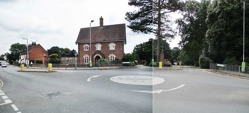 Composite
image 2021
Composite
image 2021
Standing outside the Co-op one sees Woodbridge Road from the jaws of
Brunswick
Road. The entrance to St Marys Road is directly opposite. The Case is
Altered public house is off to the left. The five
dwellings (334 to 342 Woodbridge Road)
are visible to the left of the Gothic-style
‘eye-catcher’ house opposite at 1 St Marys Road. The entry to Sunny
Place must have
been situated around the end of the flint wall to the left of 1 St
Marys Road, with a row of four small cottages running south off
Woodbridge Road at right angles. Perhaps the large brick
pillar with pointed top is a clue to the edge of the land owned by
'Holme Wood'.
Below: looking at a close-up of 'The Case' on the 1902 map, we see the
rather smaller, earlier pub building and, directly opposite, a short
passage with four small cottages in a terrace. This must surely be
Sunny Place with the frontages of the cottages facing east to catch the
sun from about noon onwards, hence the name. One wonders if they were
built for the servants of the residents of Holme Wood, the Ransome
family? Domestic servants (cook, maids) would probably have quarters in
the Big House, but Sunny Place might have housed coachman, groom and
gardeners.
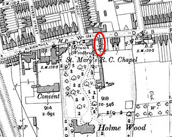 Sunny
Place (ringed in red), 1902 map
Sunny
Place (ringed in red), 1902 map
Another legend on the map which caused us some head-scratching was
'Ipswich Woodbridge' with a bracket to the left. Eventually it became
clear that this relates to 'M.P.' on Woodbridge Road which marks
a cast iron milestone (the second example illustrated on our Milestones page: no '70' outside 325
Woodbridge Road).
Holme Wood and the Catholic
church and school
Holme Wood off Woodbridge Road, behind St Mary’s Catholic Chapel
and Convent was the long time residence of the Ransome
family – famous in Ipswich as heavy engineering industralists – with
exquisite grounds and well-tended lawns. It became the home of
the Girls School of Jesus and Mary. Holme Wood (on the OS Map) is
sometimes 'Home Leigh' or 'Holm Wood' (the architect was Brightwen
Binyon for J. E. Ransome, 1882/83). The 1884 OS Map shows the
previous building on this site, Albion Hill House which was demolished
to
allow Holme Wood to be constructed. In the 21st century
the Holme Wood house was converted into flats and refurbished as a key
part of St Mary's estate.
Pere Louis Simon, a Catholic priest bought five acres of land off
Woodbridge Road before 1860 and
established a Catholic chapel. Nuns from Lyons followed and a sizeable
convent developed with part of the park being playing fields for the
girls. An orphanage was opened in 1862. All
this was swept away, of course, when the pupils were moved
to St Joseph’s College on Belstead Road in 1996 and St Mary’s housing
development happened. Hopkins Homes built flats and
houses on the site (from 2002/3). Simon Knott writes a
detailed account of Catholicism in Ipswich in the mid-19th century on Simon’s
Suffolk Churches website (see Links);
this includes further detail about the area now known as "St Mary's".
[***The Case is Altered designed by John Shewell Corder for Cobbold
& Co., 1913. The pub name derivation is opaque: one tempting source
is that the name is a corruption of 'Casa de Altaria' in Spain, where
Engilsh troops were billeted while helping the Spanish and Portuguese
forces defeat the French army between 1808 to 1814; this is supposed to
be because soldiers returning from the Peninsular War at the beginning
of the nineteenth century brought back the name. Others claim that
there is a legal derivation about new evidence in a court case – the
name appears in a number of locations, most supposed explanations have
a local connection, so don't apply elsewhere.
The original Case is Altered was reputedly built in 1815 to cater for
militia troops billeted in the area at St
Helen's Barracks. The present building dates from some time between
1904 and 1927; older maps (including the 1902 map above) show the pub
occupying only a smaller building located where the eastern end of the
present pub now stands. This has since been demolished.
Tim Voelcker discusses the possible sources of the name in an Ipswich Society Newsletter article.
1867 map
 1867 map
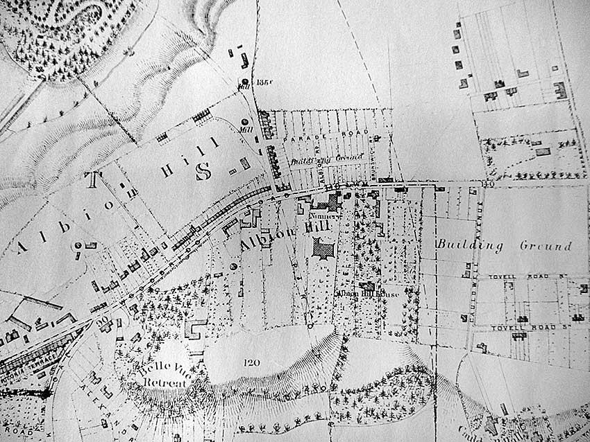
On Edward White's map of Ipswich 1867
'Albion Hill' appears twice above and below Woodbridge Road (the former
legend doesn't appear on the road itself). The upper legend runs from
about half-way down the future Lacey Street, past a windmill and all
the way up the slope to the site of the future railway cutting (opened
1877). The religious buildings are labelled 'Nunnery' with the Catholic
Church directly south of it. The 17th Century forerunner of Holme Wood
is marked (albeit indistinctly) 'Albion Hill House' (close-up below).
Overlaying the two maps (1867 and 1902) confirms that they occupied the
same site.
 1867
map detail
1867
map detail
There are a few further points of interest, particularly
the rather speculative nature of White's map here in east Ipswich as
the Freehold Land Society begin to develop the California
estate and road names have clearly changed in some cases
post-publication. Today's Rivers Street, opposite the Nunnery is here
labelled 'Albion Rd'; down Cauldwell Avenue the lower 'Tovell Road
South' is now Tovells Road and above it 'Tovell Road
North' is now Holland Road; just off the map detail to
the right, St Johns Avenue is now Nelson Road. The land
around Parade Road is laid out as unoccupied plots and labelled
'Building Ground'. Brunswick Road is
a short street. At the top left is part of the new Victorian cemetery,
opened in 1855, with part of Cemetery Road visible. Just
off this 1867 detail to the left is the legend 'MOUNT PROSPECT' on a
piece of farmland. Perhaps this fits in with the use of 'Belvedere' and
'Belle
Vue' in the road names at the top of Albion Hill. As the land rises
steadily from the river level, the views across Ipswich must have been
quite panoramic – a little less so in the 21st century with all
'The 'ouses in between' (as Gus Elan sang in 1900).
Windmills
Clearly marked between the line of the future Belvedere Road and that
of the future Felixstowe branch line
are the two 'Mills' (dark circles). Not marked as such, but shown as
a dark circle on the site of the future Post Mill Close (off Belle Vue Road) is a third mill. The
fourth is shown by a similar symbol – just below the letter 'b' of
'Albion Hill' at upper left – at the top of North Hill Road; it was not
fully developed at this time and is shown unlabelled here. Anyone
who has lived in this area of Ipswich will know that the winds,
particularly the south-westerlies, blow very strong here, so it's a
good
place to erect windmills to grind corn.
See the document detailing Windmills
in the Borough of Ipswich by Peter
Dolman of
the Suffolk Windmill Group (click the link to open the PDF).
Related page:
'Russell Villas', Belle Vue Retreat &
environs;
Parade Field Terrace and St Helen's Barracks;
Warwick Road
Windmills in the Borough of Ipswich
Home
Please email any comments and contributions by clicking here.
Search Ipswich
Historic Lettering
©2004 Copyright throughout
the Ipswich Historic Lettering site: Borin Van Loon
No reproduction of text or images without express written permission