Cauldwell
Hall Road: house names
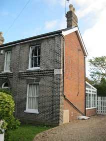
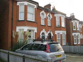
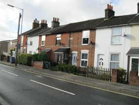
Cauldwell Hall Road runs from the Woodbridge Road/Rushmere Road
junction in the north down to the Foxhall Road/Derby Road junction in
the south. Walking from The Golden Key
southwards, its length contains a whole range of style and period in
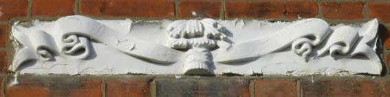
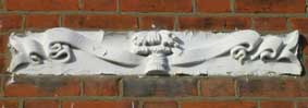
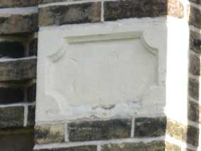
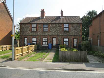
terms of house name plaques. The one featured above on number 72a is
almost unreadable due to very shallow carving of characters and
over-whitewashing. We think that it is 'ASHBROOKE COTTAGES'. The
central wheat sheaves and curled, furling scroll (and the plaque's
narrowness) make it worthy of note. Long shots are
suffixed by 'a'.
1
|
2a
|
2
|
3
|
 4a 4a |
4
|
5
|
 6a 6a |
6
|
7
|
8
|
9a
|
10a
|
11a
|
11
|
12
|
13a
|
13
|
14a
|
14
|
15a
|
15
|
16
|
16a
|
17
|
18
|
19
|
20a
|
20
|
21
|
22
|
23
|
24
|
25
|
26
|
27
|
28
|
29a (Warwick Rd)
|
29 (Warwick Rd) |
The locations of these names (from
top left)
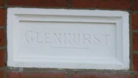
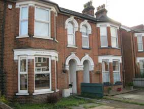
1. 'GLENHURST' is on (perhaps oddly) numbers 71 and 75 Cauldwell Hall
Road.
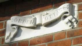
2. 'COBDEN COTTAGES' on numbers 64 and 66 is deeply carved on the
characteristic flamboyant scroll of the Ipswich & Suffolk Freehold
Land Society (compare with scrolls on the next example at number 72a
and the last, a much plainer affair). Richard Cobden (1804-1865) was a
British manufacturer, radical and Liberal statesman, associated with
John Bright in the formation of the Anti-Corn Law League as well as
with the Cobden–Chevalier Treaty, an Anglo-French Free Trade treaty.
3. 'ASHBROOKE COTTAGES' [?] on number 72a :see the top of this
page.
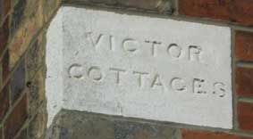
4. 'VICTOR COTTAGES' on number 94 is a corner name plaque, although it
must apply to number 92 also.
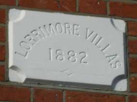
5. 'LORRIMORE VILLAS 1882' at numbers 98 and 100 is the first to bear a
date. A 1681 map of Walworth made for Dean and Chapter of Canterbury
Cathedral shows a common called "Lattam-more" (or Lower Moor), which is
now the location for Lorrimore Square, south London.
6. 'S-SLAND? COTTAGE' on the corner of number 115 is very difficult to
read.
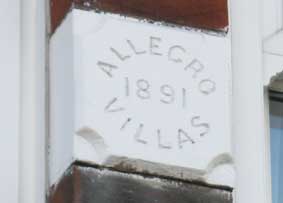
7. 'ALLEGRO COTTAGES 1891' on numbers 125 and 127 on a block
between two central windows.
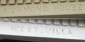
8. 'RICHMOND HOUSE' and 'WEST VILLAS' are neighbours and show
the
names on lintels above ground floor bay windows. Possibly
numbers 135 and 141? Several of these examples are here:
9a. 'MALCOM VILLA' ans 'MARJORIE VILLA'.
10a. 'CHESHAM VILLA' and 'WARWICK VILLA'.
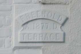
11. 'FREEHOLD TERRACE A.D. 1877' is in the centre of a terrace
above
numbers 172 and 174; commemorates the Ipswich Freehold Land Society
which was responsible for much of the housing development here.
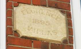
12. 'FLORENCE VILLAS 1895' above numbers 195 and 197.
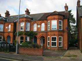
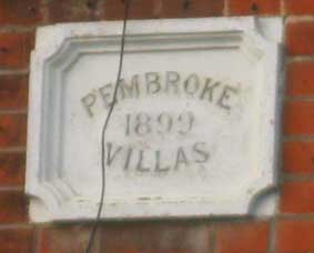
13. 'PEMBROKE VILLAS 1899' above numbers 217 and 219.
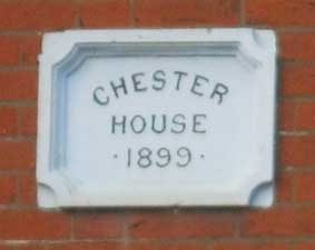
14. 'CHESTER HOUSE 1899' above number 212.
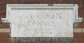
15. 'LONDON LODGE 1902' above number 257, a large double-fronter.
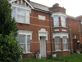
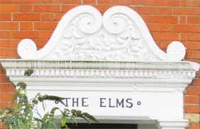
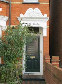
16. 'THE ELMS' above the front door of number 259.The Elms
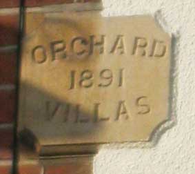
17. 'ORCHARD VILLAS 1891' above number 252 and 254.
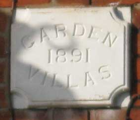
18. 'GARDEN VILLAS 1891' above numbers 256 and 258.
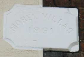
19. 'MOREL VILLAS 1891' above numbers 267 and 269; the rendering on the
left has covered the squared off corners of the plaque which are
visible agains the brickwork on the right. Morels are edible fungus.
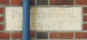
20. 'PROVIDENCE TERRACE' above numbers 266 and 268; the
decorative
incised script is somewhat spoilt by the rainwater downpipe.
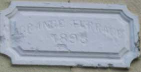
21. 'GRANGE TERRACE 1895' above numbers 287 and 289; just readable
despite
the damage.
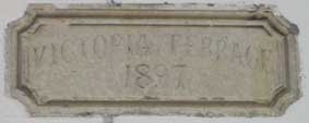
22. 'VICTORIA TERRACE 1897' above numbers 299 and 301; a curving
serif'd
font curving over the date.
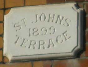
23. 'ST JOHNS TERRACE 1899' above numbers 298 and 300.
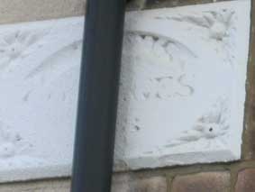
24. Unreadable '---S COTTAGES' above 307 and 309.
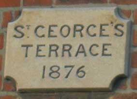
25. 'ST GEORGE'S TERRACE 1876' above numbers 310 and 312.
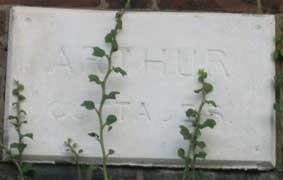
26. 'ARTHUR COTTAGES' above numbers 323 and 325.
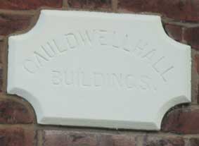
27. 'CAULDWELL HALL BUILDINGS' above numbers 331 and 333.
28. 'ARDIRE COTTAGES.' above numbers 339 and 341; unusual squared-off
scroll ends. 'Ardire' appears to be Italian for foolhardiness....
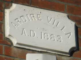
29. 'ARDIRE VILLA a.d. 1883' – but here is the name again on a house in
Warwick Road. 'Ardire' sounds Scottish?
173-177 Cauldwell Hall Road
Not named on stone plaques, but these flint and brick houses were early
developments by the Freehold Land Society; see
our California page for more.
Shopping in Cauldwell Hall Road in the
1950s
As so often, David Kindred's Kindred
Spirits website (see Links) provides a
fascinating memoir by Rod
Cross (who grew up in Clifford Road) of family shopping in this area.
'Rod said: “Cauldwell Hall Road may not immediately spring to mind as
one of the more exotic or remarkable roads in Ipswich, but along with
its widely diverse range of buildings, which represent almost every
decade since the middle of the 19th century, it can also lay claim to
being the longest completely straight road in the whole town. It is
possible to stand outside the Golden Key
on the corner of Woodbridge Road and see the traffic lights by the
Railway Hotel in Foxhall Road, just under three quarters of a mile away.
“The road owes its unusual name to the unimposing hall, which still
stands at the bottom of Cauldwell Avenue. It was the main residence of
the vast Cauldwell Hall Estate, so called because of its 'cauld wells'
(cold wells), which were the principal source of water for the north
east of the old town.
“In 1849, nearly 100 acres of this estate were acquired on behalf of
the Ipswich and Suffolk Freehold Land Society.
Roads were constructed and the land divided up into 282 plots or
“allotments”, which members of the society could purchase for £21.10s
to build homes. It became such a common sight to see shovel-carrying
workers trudging up Spring Road, like the gold-diggings in the USA,
that the area became known as California.
“Its population of just 100 in 1851 increased more than tenfold within
20 years and by 1904 California was almost completely built up.
Cauldwell Hall Road was an integral part of this housing boom, as
evidenced by the plaques on the houses today: St George's Terrace 1876,
Lorrimore Villas 1882, Chester House 1899 and London Lodge 1902. [All of these examples shown above.]
“I was totally oblivious to its historical pedigree when, as a small
boy in the mid-1950s, I accompanied my mother to what I knew as
“Cordlawl” Road to do the weekly shopping. The first stop was always J
S Hotson and Sons, on the corner of Marlborough
Road. This was a traditional family grocer's shop. It had bare
floorboards and, down one side, a solid wooden counter, on which stood
a shiny red bacon slicer. In one corner were open hessian sacks
containing washing soda, flour, sugar and various types of dried fruit,
all to be weighed out and bagged up as required.
“The white-coated proprietor who, strange as it seemed to me at the
time, was not called Mr Hotson, but Mr Bush, would write down mother's
order in a little notebook, while I would be carefully examining each
and every box of Weetabix or Cornflakes. These often contained various
free gifts, whilst the back of the packets sometimes bore designs for
models such as vintage cars. These had to be cut out, folded and glued
together. Only careful scrutiny ensured that I made the right
selection.”
I also selected the biscuits, Rich Tea, Nice or Osborn. They were all
sold loose with their individual tins lined up on a shelf. There was
also a tin labelled 'broken biscuits', priced a little cheaper than the
others. Once the complete order had been taken, Mr Bush would pack
everything into a stout cardboard box ready for delivery by Les on his
tradesman's bicycle later that day.
“Shufflebotham's Bakery stood on the other corner of Marlborough Road
where it joined St John's Road. Because these roads met at an angle,
the shop was V-shaped. Customers entered from the “pointed” end and
walked down the ever-widening shop floor to the counter at the bottom.
Loaves and other bakery products were displayed on shelving down the
right-hand side. Mother always bought an un-sliced Devon loaf,
freshly-baked. We never got to eat it until much later in the week,
once the old had been consumed down to the last crumb! At that time a
large loaf cost 4½ [old] pence!
“Crossing St John's Road we sometimes called into Mrs Savage's
haberdashery before reaching our next port of call. Bloomfield's was a
little butcher's shop with scrubbed wooden tables and a sawdust-covered
floor. It was founded by Isaac Bloomfield, but I only remember Albert
Bloomfield, the short, elderly proprietor and his young assistant, the
tall, young, sleek-haired Ray Sale. Ray, a county bowls player, later
bought the shop. At Bloomfield's we bought shop-made sausages and pork,
cheese, liver and the weekly joint of lamb, mutton or beef.
Bloomfield's also supplied our Christmas chicken, which had a lovely
savoury flavour, totally absent in today's factory-reared birds.
“Opposite was Dean's greengrocery. For convenience we mostly bought our
fruit and vegetables from the Co-op, whose
horse-drawn greengrocery cart paid a twice-weekly visit to our road,
but we usually found some reason to visit Mrs Dean to stock up on what
we were short of.
“Passing Alex Fordham's betting shop, we would cross back into
Marlborough Road opposite the off-licence on the corner of Freehold
Road and head home. The weekly shopping was all done within a radius of
some 50 yards and from shopkeepers who were all specialists in their
particular field.”
In the 1950s there was far more to Cauldwell Hall Road than just the
shops we visited. There was a hairdresser and a fearsome dentist named
Pritchatt. Further along, between Fuchsia Lane and Foxhall Road, was another row of shops,
including a general store, a newsagents, Durrant's electrical
engineers, a furniture shop run by Gardiners and an upholstery
business, which my uncle, Lew Fitch, took over from Albert Todd.
Opposite was Blackburn's the chemist, who also ran a confectioner's
next door.
“Today, of all these businesses, only the ladies hairdresser's, one of
three clustered round the Marlborough Road junction, and the
off-licence remain. The others have been converted into private homes
or demolished and rebuilt.
“In the other direction, towards Woodbridge Road, were more shops.
These included a fishmonger's, a wool shop, a fish and chip shop and a
Co-op store. Opposite the Co-op, on the corner of Upland Road, was the
garage for the Co-op bakery vans. These little, red, box-shaped
vehicles were powered by electric batteries, which were recharged every
night. This created a gentle, not unpleasant, humming noise, which you
could hear as you walked by. This site is now another housing
development.
“Beyond the Spring Road traffic lights and The Old Times public house,
the character of Cauldwell Hall Road changed and it became rather less
residential. It was dominated by the massive red-brick St John's
Church. Next door was the church hall and the chapel of rest, with the
Mount Zion Baptist Church opposite and the original St John's Primary
School.
“In the schoolyard children played in their distinctive purple blazers.
Finally there was a furniture remover, Pawsey's wholesale warehouse and
an engineering works. Near Woodbridge Road was Welham's, a traditional
grocer. Each of these landmarks became extremely familiar to me as,
every day for seven years, during the late 50s and early 60s, I cycled
to school.
“One in particular came to have a special significance. This was the Lion's Head on the corner of Freehold Road.
At the rear of the pub was a billiards room containing a full-size
snooker table. Once old enough, we would time our journey home from
school each Wednesday to coincide with the pub's five o'clock opening
time and then spend a blissful hour on the table.
“Fred Rattle, the bluff, shirt-sleeved landlord was not over-keen on an
invasion of his pub by schoolboys with little money to spend. We would
try to avoid his eye by not using the main entrance, but by entering
the pub through the door at the rear. There was also an elderly barman
called Albert. We called him 'Post' as he was extremely deaf! Ask for a
packet of hamburger crisps and you could well end up with a small
shandy!
[http://www.ipswichstar.co.uk/news/features_2_511/when_the_shopping_was_a_local_event_1_164335]
Related pages:
House
name plaque examples: Alston Road;
Broom
Hill Road;
Burlington
Road;
Bramford Road;
Cavendish Street;
Marlborough Road; Rosehill area;
Ipswich & Suffolk Freehold Land
Society (F.L.S.); California
Street index;
Origins of street names
in Ipswich; Streets named after slavery
abolitionists.
Dated buildings list; Dated buildings examples;
Named
buildings list;
Named (& sometimes dated) buildings
examples.
Street nameplate examples; Brickyards
Home
Please email any comments and contributions by clicking here.
Search Ipswich
Historic Lettering
©2004 Copyright
throughout the Ipswich
Historic Lettering site: Borin Van Loon
No reproduction of text or images without express written permission