Courts
and yards in eastern Ipswich, 1880s
Charles Court, Wells Court, Shire Hall Yard, Lower Orwell
Street, Wingfield Street, Tankard Street
'5 January
2014. Just a "thank you" for the superb content on the
Ipswich lettering website. I have been researching my family history
for almost 50 years... they lived in St Clement/St Helen's parishes for
over 200 years, clearly in dire poverty. Your maps and insights add so
much colour and flesh to my image of their lives. Thanks, John
Welham'
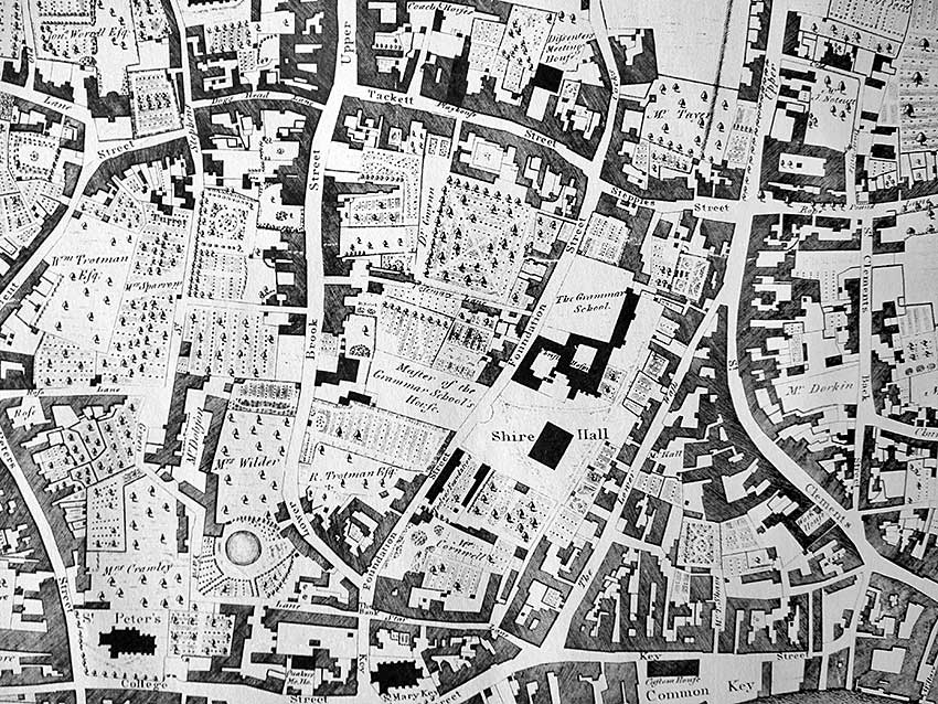
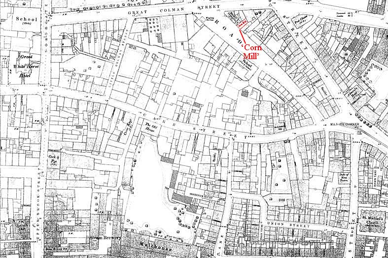 1881 map
Carr Street area
We came
across this 1881 map detail which gives some
impression of the
density of lowly housing particularly in the east, bordering The
Potteries area. Cox Lane is at bottom-centre meeting Carr Street.
Running horizontally across the
centre is Carr Street from Majors Corner (where the tracks of the
horse tramway teminate – they weren't replaced by electric trams
until 1903) on the right to Upper Brook
Street
on the left.
See our page on The Potteries for a 1902
map from Cox Lane to Alexandra Park.
Notable features:-
1. Little Colman Street (upper
left) is there; the East Anglian Daily
Times printworks would be built in 1887 on the corner of Little Colman
Street and Carr Street and this was eventually demolished (1966) along
with the street, the Lyceum Theatre and all the neighbouring shops
before the
imposition of the disastrous 'Carr Precinct' – most of it
is now a cut-price store;
2. The building opposite the jaws of Great Colman Street is clearly
marked 'School (Girls)'; see
our Egerton's
page for more on this lettered building;
3. Upper Brook Street is very
narrow between the Symonds
Chemists corner and The Great White Horse;
4. Between Upper Brook Street and Cox Lane (centre, bottom of map) is
the
'Steam Brewery' and
'Malthouse'; these lie to the south of a large open
yard behind what was to become the Woolworth's store (marked 'The Old
House', which appears to have a large garden behind it reaching down to
the Malthouse); in 1856 Charles Cullingham and Ashton Blogg (who had
previously had a small brewery in Foundation Street – probably where The Unicorn Brewery stands today) had set-up a
Steam Brewery here. From 1873 its proprietors were Charles Cullingham
and Frances Blogg; by 1885 Cullingham was sole proprietor. The company
was a large concern, owning sixty-nine pubs and maltings. It was bought
by the Tollemache Brothers in1888 and it closed in 1958
when 'Tolly' merged with Cobbold, leading to eventual demolition to
become a car park;
5. Across Cox Lane is an indication of the extreme density of housing
in this poorest part of Ipswich at the time stretching eastwards: Union
Street,
Goodings Court, Union
Court, Daniela Court, Charles Court (see photographs below),
Well Court, Craig Court and Cook's Yard are visible; much of this area
(including the small Permit Office Street – so named because
an
inhabitant was an official who issued Custom & Excise permits)
was
demolished and became the Cox Lane car park; Watts
Court (scroll down)
further down Foundation Street still had a couple of
the
original small houses until 2013.
6. Apart from the still-standing Great White Horse, The Cock &
Pye
and The Salutation, we can see the following hostelries:-
- Steam
Brewery Tap/Inn: 39 Upper Brook Street, north of the archway;
see our Old Cattle Market page for
a closer look at these buildings;
- The Coach & Horses: 41
Upper Brook Street, south of the archway with its Winged wheels emblem);
- The Cross Keys Inn: a
coaching inn at 22 Carr Street which existed there before 1650 and
closed in 1938; the original building was extensively rebuilt when the
street was widened (c.1887-88) to allow trams to pass, now a charity
shop; see our Symonds page for more on The
Cross Keys;
- The Marquis of Cornwallis:
on the sharp corner of Old
Foundry Road and Great Colman Street, next door to a 'Corn Mill'
(marked in red above)
see our Vestiges
page);
- The Post Chaise: at the very
tip of St Margaret's Street and
Woodbridge Road with a loop lane behind it linking the two
roads; standing opposite The Mulberry Tree,
still standing today;
- The Admiral's Head: opposite
the jaws of
Carr
Street, on Major's Corner);
- The Duke of Kent Tavern: 10
Upper Orwell
Street
on the opposite side to
the St Michael Church, for many
years the former public houses was the offices of the Co-op funeral
service – see our Co-op page for a
photograph; a Urinal is marked
behind tenements on the
opposite corner to the church.
7. Note that the prominently-marked 'The
Old House' on the south side
of Carr Street was the home of James Allen Ransome (1806-1875),
director of Ransomes Sims and Jeffries. His extensive triangular garden
is to the south of the house. Ironically, perhaps, what must have been
a rather fine house fronting Carr Street is today a Poundland store
(formerly Woolworth's in one of the ugliest buildings in Ipswich); the
gardens are either built on or part of
today's car park. Such is progress.
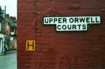
'Courts' and 'Yards' were small clusters of poor, overcrowded housing
often grouped around a small yard and accessed from the street by a
narrow passage. 'Upper
Orwell Courts'
still has its street sign, but is now just a narrow lane between Upper
Orwell Street and Bond Street. Muriel Clegg (see Reading
List) writes of houses (mainly one room up, one room down) with no
gas, electricity or
sanitation when an additional income could be had by storing human dung
from the inhabitants in a tank in the yard which was collected and sold
on to farmers to manure the fields. The stench and danger of disease
can only be imagined. In
the 1880s a network of sewers was dug in Ipswich (a notable feature of
those dug down the centre of Westgate Street was the discovery of a
series of medieval
burials. This work may well have been in progress at the time of the
above
1881 map. Through the 19th century private companies provided the water
supply but in 1892 the council took them over. See the Ragged Schools page for other signs of
extreme poverty in Ipswich when apparently its economy was booming...
 Rags & bones
A key source of information on this subject is Frank Grace's
excellent book Rags & bones
(see Reading List) which meticulously
documents the truly awful poverty of eight to nine thousand people
living in St Clement's parish in the 19th century. One or two examples
really bring the squalor to life. The area known for many decades as
'The Potteries' – roughly the site of
Suffolk New College, with the
'cliff' (scarp) up to Alexandra Park probably caused by clay-digging
was probably the source of raw material for the seventh and eighth
century wheel-thrown
pottery which was widely distributed in Britain and the Rhineland and
which is called by archaeologists
'Ipswich Ware' because of its characteristic composition and glaze. A
stratum of white clay was estimated by historian John Glyde in 1850 to
be thirty feet deep in this area
and there was, of course, plentiful local, fresh spring water. The
greatest number
of kilns was found just inside the late Saxon rampart and ditch which
ran down what is now Upper Orwell Street and 'St Helen's pottery
ground' succeeded these kilns in later centuries.The decline of this
ancient trade is the story told in Rags
& bones. In addition to
The Potteries, Rope Walk (literally a
rope manufactory) and the area
reaching round the bend in the dock from Neptune Quay and down the east
bank to Myrtle Street experienced a massive change from the 1820s. The
Rope Walk and Rope Lane were once cut off from the river by meadows
until Long Lane was cut through. The remnant of this today is the
southern stub of Long Street between the College and the University
running from the bottom of Back Hamlet into car parks. This lane was
eventually to form one of the worst slums in the town. The decline of
pottery, tile and brick-making as well as rope-making seems to have
triggered a burst of trading in plots of land, rapid building of
'cottages' with small pubs on the corners, grocery shops etc. (For a
1902 map of much of 'The Potteries' area, see our Potteries page; also the Holy Trinity Church page.)
All of this was driven by the profit-motive, not by philanthropy. Very
little or no attention was paid to decent infrastructure: paving,
drainage, access etc. Because it catered to the housing demands of the
lower and lowest strata of Ipswich society, the result was the building
of slums with appalling sanitation, overcrowding, disease and
exploitation of the inhabitants. The distance between the frontages of
the cottages varied from less than fifteen feet in David Street, even
less in Baker Street and nine feet in Short Lane. The last of these was
200 feet long and in 1881 there were eighteen households with 102
people
living there. It was similar in many ways to present-day shanty towns
which grow up on the edges of conurbations. Many of the people making
money from these ventures were
supposedly upstanding members of Ipswich society. People with power,
wealth and influence: politicians, mayors, businessmen resisted any
social reforms for decades, despite overwhelming evidence collected by
the Medical Officer of high mortality and degrading living conditions
over a large area of the town where 'repectable' persons might fear to
tread. The stench would certainly put them off. So much for the
enlightenment of the Victorian industrial
revolution and its resultant immense wealth and 'prosperity'.
'Cottage' is a word we like to associate with roses round the door and
a pleasant garden, perhaps a thatched roof. In the Potteries it was
more
commonly a 'single house', no more than a two-roomed shed with a blind
back, no doors or windows at the rear. In 1881, one such dwelling in
Clark's Court housed thirty-three people. The toilet would have to be
emptied by hand, through the house. Many cases of inadequate drains
becoming blocked are reported with the surrounding ground, paths and
buildings becoming contaminated with effluvia. Slums reported as being
health hazards, damp, overcrowded, disease-ridden, were no more than
twenty years old in some cases, so the landowners were not just
building the slums of tomorrow, but virtually the slums of today. There
are examples of builders being unable to finish their work because the
inhabitants were so desperate for housing that they moved into
unfinished premises. Needless to say, the builders gave up and left
houses unfinished. Some jerry-built houses on the clay layer of the
Potteries site, close
to the scarp either fell down or had to be demolished only ten years
after erection. In the 1880s a network of sewers was dug in Ipswich and
eventually the major contamination and public health problems of 'The
Rope Walk Insanitary Area', as it had come to be known, were
ameliorated. (Between 1879 and 1881 the sewer outlet was built
downriver from the dock.) In the 19th century private companies
provided the water
supply but in 1892 the council took them over. See our Street furniture
page for a note about Ipswich Water Works. Drainage, sewers, water
supply, paving, slum landlords: all unromantic subjects, but crucial to
the
chequered history of Ipswich and its people.
Another feature of the population of the Potteries area in the 19th
century detailed in Rags & bones
is its restless nature. People were coming into the area to seek for,
usually, very low-paid work then moving around to different addresses,
moving away and sometimes returning. Whatever societal structure
developed happened despite this perpetual motion. For the powerful
employers of the day, notably the dominant Ransome's, Sims and
Jefferies engineering works, this would be called "a flexible
workforce"...
An 1850 perspective
‘There are 106 courts in the town,
containing 627 houses. The drainage from some of these is very
defective. In some instances all the refuse water has to be carried to
a dead well, situated either in the middle or at the end of the yard.
In others, the water course is very badly paved, and stagnant water is
the consequence. The demoralizing practice of providing but one
convenience for several house is here seen in full force. No less than
67 courts, containing 358 houses, are in this position; giving an
average of one to every five houses. The courts are also equally
deficient in accommodation for the washing of clothes. Many of the
inhabitants have to perform that operation in their dwellings, to the
serious injury of their health and destruction of their comfort. The
supply of water to the courts is also of a defective character. Ten of
them are without any supply, to 4 the water they require is fetched
from the wells, and to 21 from pumps. The difficulty and labour
attending the procuration of this needful article, must have
deteriorating influence on the character of the inhabitants, and
prevent the formation of those habits of cleanliness so essential to
the health, comfort and moral elevation of the poorer classes. The
ventilation of the courts is bad, their situation often very confined,
and the entrance in some instances narrow. Some of their houses are
situated back to back. Above 500 of them have no back doors; and, in
the major portion, the rooms are so small that, where they are occupied
by families, they cannot fail of being crowded in the sleeping
apartments.’
Contemporary description of insanitary courts, John Glyde: Moral, social and religious condition of
Ipswich, 1850; quoted in Grace, F. The late Victorian town (see Reading list).
Frank Grace's The
late
Victorian town is a very interesting 'slim volume' designed by
the author as a teaching guide to research. Much of the book relates to
Ipswich and it is full of passages such as that above, also
insights into Franks' working methods and the way in which the stories
of people can be reconstructed from historical sources.
Charles Court, off Upper
Orwell Street
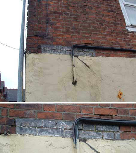 photos courtesy Dave
Riseborough
photos courtesy Dave
Riseborough
Above: 'CHAR[?]..S CT'
a street name painted on the brickwork of a wall at the
end
of the stub of Union Street (off Upper Orwell Street). Dave Riseborough
writes: 'On old maps I looked at on the internet it looks as though
there was a court there, but it is not named on the maps). It is
located up Union Street, off Upper Orwell Street. Towards the end, on
the left, there is an old building (I seem to remember reading
somewhere that this is an example of the old slum buildings that were
there and which was left after the slum clearances, but I can't be
sure) the sign is on the rear of this building...'
Certainly there is no name (not even Union Street)
on the map of Ipswich by Edmund White, 1867. The two streets crossing
at right-angles between Upper Orwell Street and Cox Lane are named
Barclay St and Office St. However, an Ordnance Survey (scale 1/1250)
map of 1883 given to us by Hilary Platts some years ago shows all the
names in this rabbit-warren of the poorest Victorian housing in the
centre of the town. This clearly shows, on the north side of Union
Street, Well Court and directly opposite: Charles Court. Thanks to Dave
Riseborough for bringing this hidden corner of historic lettering to
our attention. Below: location photograph of the vestigial Charles
Court lettering.
 2014 image
 See Upper
Orwell
Court and Dove Yard for this and other metal street name
signs.
See Upper
Orwell
Court and Dove Yard for this and other metal street name
signs. 
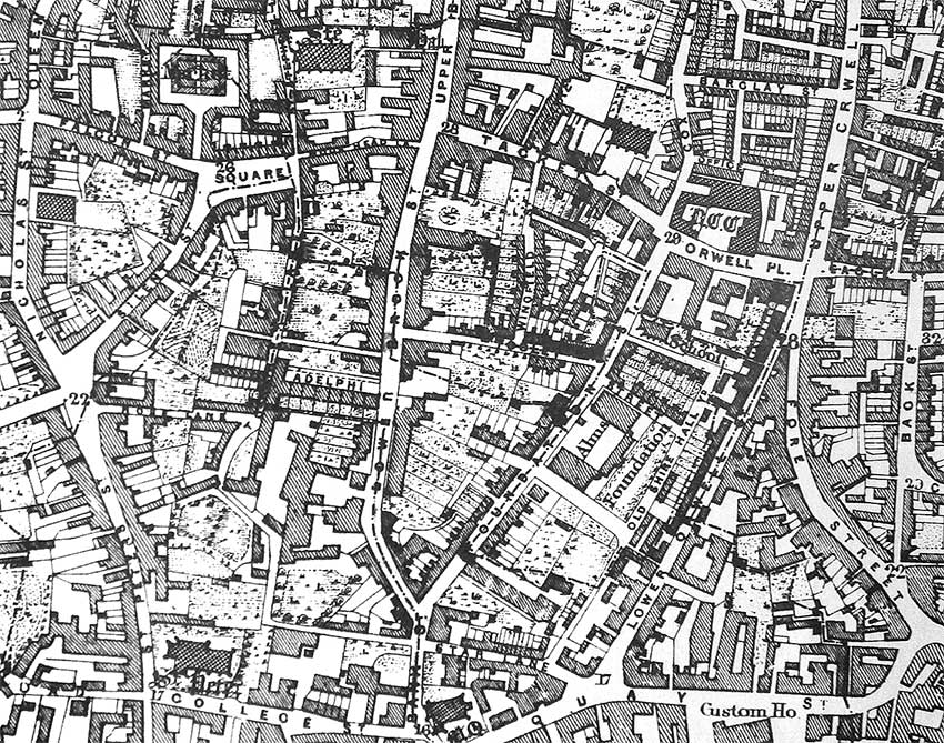
Shire Hall Yard area, off
Foundation Street
A comparison of Pennington's
map (1778) and White's map (1867), is
recommended by Muriel Clegg (below).
This detail of the 1778 map of the
area shows
the Shire Hall (built in 1699) at the centre with,
to the east of it,
today's Lower Orwell Street (labelled 'The
Lower Wash' here, running with spring water). 'Stepples Street'
(today's Orwell Place), named after the stepping stones which helped
people to cross the road without getting their feet wet, is at the
upper right. See our page on Water in Ipswich
for more on the springs and rivers.
The lane today called Pleasant Row runs from Shire Hall
southwards towards Star Lane and the dock. 'The Bank' (the 'Yellow
Bank', as distinct from Cobbold's Blue Bank– Whig and Conservative
respectively) is shown in Star Lane at
the southern end of Foundation Street; for a time it gave the name
'Bank Street'
to the small section of road down to 'St
Mary Key' Church. Here it is shown as a section of Key Street
curving round the church. This tiny road has also been treated as a
continuation of Foundation Street.
Today's Fore Street drops down from the Spread Eagle crossroads and
curves to the east but in 1778 it is labelled by Pennington 'St
Clements Fore Street'.
 1778
map
1778
map
Watts Court doesn't exist in 1778; the site is an orchard across
Foundation Street from Shire Hall and beside 'The Master of the Grammar
School's House'. By the 1867 map Watts Court runs off the street to the
west between the 'D' and the 'A' of 'FOUNDATION' with a few dwellings.
The map of 1881further down this page actually labels 'Watts Court'
in this position (shown here in red), now fully built up with small
cottages on both sides. The Shire Hall has disappeared by this date,
 1867map
Below: this second map of 1881 is south of
that shown at the top of the page and labels the area 'Shire Hall Yard'
at
its centre lying between Foundation Street and Lower Brook Street. Tooley's and Smart's Almhouses (built by
J.M. Clark in 1846) lie underneath that caption. Many
features have changed or gone forever and the density of housing is
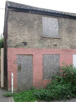
very striking. One survivor is the small house in Watts Court, still
standing until 2013 (see below). Watts Court
(shown here in red)
is off the west side of Foundation Street, level with the lower Shire
Hall Yard: this is now called Smart Street, where Smart Street School (marked as 'School -
Boys and Girls') can be seen, and that
page contains more information on 'Shire Hall' itself. Tooley Street (which is now called Blackfriars Court,
presumably renamed following
the rediscovery of the ruins of that monastic church nearby) completes
the northern part of Tooley's Almshouses
rectangle. Parallel
with and just north of that is the long-disappeared School Street, the
original site of Christ's
Hospital School with the Unicorn Brewery
above it.
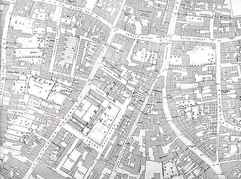 1881 map
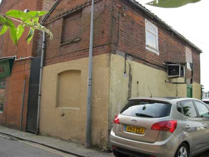
Watts
Court, Foundation Street
[UPDATE 21.8.2012: "I stumbled
on this very interesting site. I know there were several courts
built for the poor in Ipswich, usually built behind houses on the main
streets. My mother was born in Craig Court off Upper Orwell St,
she grew up in Watts Court off Foundation St. In fact two of
these very small houses off Foundation St. still survive, they are now
used as some kind of storage facility. It would be great if you
could put a picture of the houses on your site before they disappear.
Also is are there any photos in the archives of these two courts.
Thank you for your time, Kind regards, Carolyn Saxon." In response to Carolyn's email, we have
added the maps of courts and
yards on this page and here are her 2013 images of those
houses. Thanks.]
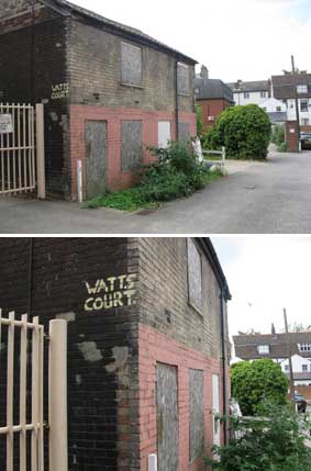
 2011 photographs courtesy Carolyn Saxon
[UPDATE: By spring 2013, this
humble building had been demolished (see below). "Unbelievable!
Doesn't anyone in Ipswich who has any say-so have the foresight
to save anything of historic value? I'm so glad I
took those pictures when I was home last (2011) & passed them on to
you. Just in the nick of time it seems. Thanks for letting me
know, Carolyn" (13.7.2013)]
 2013 image
Muriel Clegg:
‘Under the twin pressures of rapidly growing population and the demands
of industry, Ipswich, in common with there towns early in the
nineteenth century, embarked upon the dual policy of opening up the
town by the creation of new streets and infilling with rows of little
houses wherever space permitted. The departure of the better off to new
developments on the outskirts of the town left vacant the gardens and
orchards which for centuries had been a feature of the town. One has
only to compare the maps of Pennington (1778) and White (1867)*** to
see
the results. There is endless fascination in looking through nineteenth
and early twentieth century directories at the names of the little
courts, rows squares and cottages, often bearing the names of those who
built them. In the long history of the town it was a short-lived
development. The name-plate Watt’s
Court until recently hung as a solitary memento of that period,
when the town was crammed with people who actually lived in it. Watt’s
Court has been redeveloped but no-on lives there now. If nostalgia
threatens, a quick look at the 1874 report of the Medical Officer of
Health for Ipswich is an instant corrective. No-one can regret the slum
clearances begun ‘in earnest’ in the 1920s when many hurriedly built
and deplorably insanitary little dwellings were gradually swept away.
Yet during that phase of almost wholesale destruction when older
buildings shared the fate of newer, much was lost which a later
generation, bent on conservation, might have saved to grace an almost
denuded town. But the streets designed to open up the town and to
provide through ways are still with us.
'One of the earliest was Great Colman Street. The new road entailed the
purchase of ‘Harebottle’ House with one-and-a half acres of land,
offered for sale at the Great White Horse Hotel on 5th June, 1821. The
last occupant of the house was Mrs Elizabeth Edge, widow of the Revd.
John Edge, rector of Naughton and vicar of Rushmere. Unfortunately the
particulars of sale show only the new lay-out and do not describe the
house, which was to be demolished. Harbottle House (to give it its
original name) was a Tudor house built by John Harbottle, a successful
Ipswich cloth merchant who acquired property at the corner of Carr
Street and Northgate Street in 1538. Gradually he extended his
possessions in a north-easterly direction, building himself a house
described as ’lately built’ in 1539. The house was sold by his great
grandson, Sir Harbottle Grymston, in 1633. Little Colman Street was the
back driveway from the stables to Carr Street. Here was a Tudor house
which can be placed in context, but it is lost to us. A few years
ensued before the proposed new road was constructed. On August 21st,
1823, the Suffolk Pitt Club held its anniversary meeting in a temporary
building on the site. Clarke, whose History of Ipswich was published in
1830, wrote of it as only a proposed new road at the time. The new
street took its name from the Colman family, shown by Pennington as
having property there. Useful it may be, but the new street created a
confusing little pattern by cutting across the double encircling lines
of Old Foundry Road and St Margaret’s Street.’ Clegg, Muriel: Streets and street names in Ipswich
(see Reading list).
[*** See the comparison of these two maps of the Foundation Street area
shown above.]
"The usage of these street names is relatively modern. Muriel Clegg in
her booklet Streets and Street Names
in Ipswich [see
Reading List] describes the history of each.
Lower Orwell Street
follows the course of a natural stream the ‘Cauldwell
Brook’ that flows ‘from high ground to the east of the town
gave its name and its course to Spring Road. Swelled by more water from
Warwick Road (formerly Water Lane) the stream continued its course
along St Helens Street (Cauldwell – 'Cold well' – Lane) to Majors
Corner
where there appears to have been another stream. There it turned down
Upper and Lower Orwell Streets (the “Wash”) to reach the
river’. In 1959 ‘excavations in Shire
Hall Yard, behind
Lower Orwell Street, revealed that the rampart [of the town’s
walls] was constructed above a ditch (probably a boundary ditch of
between AD900 and AD1100. The stream bed provided earth and gravel for
the rampart, and itself, widened and deepened by these operations,
provided an outer ditch probably 18 to 20 feet wide’. The street
previously known as the ‘Wash’ or ‘Key Lane’
has never been a major thoroughfare. The ditch separated the area of
this site from the medieval town and in medieval documents property in
this area is described as in the suburbs of Ipswich. Fore Street
‘was originally St Clement’s Street’ or St
Clement’s Fore Street’. By the early eighteenth century the
name Fore Street had appeared, reflecting the approach to the
‘fore’ or foreshore, no longer apparent since the
construction of the Wet Dock opened in 1839...
Occupants of Lower
Orwell Street in 1881
It is possible to identify the essentially working
class nature of
Lower Orwell Street in the Victorian period from the list of occupants
and their trades as published in1881 Directory
of
Ipswich. The houses along this eastern side of the road were
listed in the reverse order beginning with: John Taylor the then
publican of the Gun Inn.
The other occupants of the street were:-
43 J.
Clarke, blacksmith,
41 Thomas Pettitt, chimney sweeper,
39 Peter
Lawson, tailor,
37 George Simey wheelwright,
35 Ebenezer Robinson, ship
builder and William Bennett mariner,
31 Peter Smith blacksmith and
wheelwright,
29 James Lord, hawker, and again Peter Smith and George
Simey,
27 Mrs Garrod, staymaker,
28 Joseph Church, shoemaker,
25 was
vacant,
23 George Andrews, french polisher,
21 Robert Powell,
brickmaker, and G & O Ridley, wine merchants,
19 & 17 John
Garrod coal dealer, (his premises adjoined Garrod’s Court),
15
Mrs L Southgate, machinist,
13 & 11 Thomas Harvey, baker,
9 Mrs
Collier charwoman,
7 Samuel Barrell, engine driver,
5 Mrs Cook, and
3
Walter Powell, labourer.
These were not the owners of the properties.
Behind the street frontage there were commercial premises sometimes
linked with the cottages or small houses along the street frontage. In
July 1892 a ‘Capital Freehold Malting Premises with stable,
coach-house & large yard also Five Freehold Cottages Tenements
forming one block with an area of about 45 perches, having long
frontages’ were offered for sale ... These were
situated in ‘Lower Orwell Street in the parish of St Mary Key,
Ipswich’. The malting was described as ‘Brick-And-Tiled
… with Three Floors, 80 Coomb Steep, Barley Chamber, Kiln,
Screening Room and Malt Store with Capital Well and Pump on the
premises, in the occupation of C. H. Cowell Esq’ and ‘New
Brick-And- Tiled Stable with large yard adjoining the Malting in the
occupation of Mr Gummersome also, adjoining, Five Freehold Cottage
Tenements & Wheelwrights’ shop, being numbered 21, 23, 25, 27
and 28 Lower Orwell Street’. The description continues ‘The
Whole forming a complete block with a Frontage to the Street of about
84 feet, and a Frontage to a Cartway on the south side of the premises
of 135 feet’. The premises were considered to be ‘well
worthy the attention of gentlemen engaged in Mercantile
pursuits’. The vendor was a Mrs Debora Barker."
(The above passage is an
edited version of an Appendix to a Suffolk County Council
archaeological assessment of Essex
Furniture Site, Lower Orwell Street, Ipswich, 2007.
http://archaeologydataservice.ac.uk/catalogue/adsdata/arch-415-1/dissemination/pdf/suffolkc1-32281_1.pdf)
Wingfield Street (named after Wingfield's House)
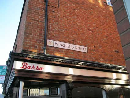
A lane at its junction with Tacket Street; it elbows round to
meet Foundation Street, but its much smaller today than in the above
mid-1880s map (also shown on our Brook
Street page relating to Rosemary Lane). See Street name derivations. Our page on Tooley's & Smart's Almshouses shows a
1902 map of the area with Wingfield Street and Little Wingfield Street clearly shown.
See also our Christ
Church
URC/Baptist page for the Listing text relating to the
still-standing rear wing of Sir Anthony Wingfield's 16th century
mansion, next to the church, both of which stand back from today's
Tacket Street north pavement.
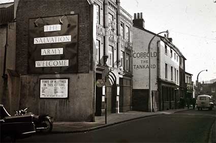
Tankard Street: the theatre and Salvation Army Citadel
 Photo
courtesy Ipswich Society Image Archive
Photo
courtesy Ipswich Society Image Archive
Above is a view of the north side of the narrow Tankard Street
(now Tacket Street – see Street name
derivations) looking east. The Tankard Inn had begun life as a
private house bought by Sir Humphrey Wingfield* from a Mrs Falstof –
probably after 1516 (the entrance to Wingfield Street is
opposite) which he decorated in palatial manner. Henry Davy's engraving
in Clarke's History and Description
of the Town of Ipswich (1830) [see Reading
list] shows that the magnificent panelled ground floor room with
even more elaborate ceiling decoration survived as a public room in the
Tankard Inn. It did so until Henry Ringham, woodcarver and church
furnisher (whose Gothic House is in St Johns Road, shown on our California page), was in 1856
instructed to strip the room of its panelling, repair it and use most
of it to line the walls of the study at John Cobbold's residence, Holy
Wells. In 1929 the oak overmantel and wall panelling, some of it
heraldic, was moved again to find a permanent home in the Wingfield
Room at Christchurch Mansion.
[*Sir Humphrey Wingfield
(c.1481-1545) was an English lawyer and Speaker of the House of Commons
of England between 1533 and 1536. For more on his fascinating life and
relationships to Charles Brandon (c.1484-1545), Duke of Suffolk who
married Mary Tudor (1496-1533); also to Cardinal Wolsey and to Ipswich
and its county – see The
Wingfield Society website.]
See also our Withypolls memorials
page for Sir Humphrey's role (along with his neighbour, Sir Thomas Rush) in the sale of the
Holy Trinity Priory site and the early days of Christchurch Mansion.
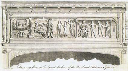
Above: the illustration of the 'overmantel' from the Great Parlour in
the Tankard Inn, from Blatchly, J.: Isaac
Johnson, see Reading list.
From 1738 of the eastern part of the Wingfield's
House was used for the Tankard Inn and the
western part of the site for a Playhouse. The Salvation Army Citadel in
the foreground of the above image began life on the
site of the
first permanent theatre in Ipswich; it was built by Henry Betts, a
local brewer and owner of the Tankard Inn in 1736. In 1741 it is
claimed that an unknown
actor called Lyddal made his debut appearance as an African slave
called Aboan in Thomas Southerne's play Oroonoko. This unknown actor was in
fact the soon-to-be-famous Shakespearian, David Garrick. The original
theatre was replaced by the Theatre Royal in 1803. It closed as a
theatre in 1890 and became a Salvation Army barracks. All of the
buildings in this view were demolished during the widening of Tacket
Street (the Citadel relocated to Woodbridge Road in 1994). Today’s
entrance to the NCP car
park covering the site of the
old Steam Brewery is at the immediate left of this picture. Even after
conversion into a Salvation Army Citadel, it is said that parts of the
'auditorium' comprised some original theatrical fittings.
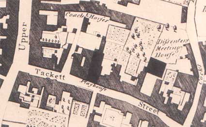 1778 map
Above: a detail from Pennington's map of
Ipswich, 1778 showing the 'Playhouse' clearly labelled in 'Tackett
Street'.
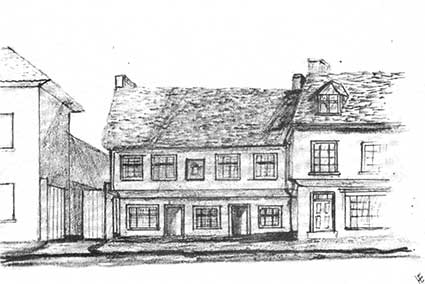 Tankard
Innc.1830
Tankard
Innc.1830
Above: The Old Tankard in around 1830, converted from part of Sir
Anthony Wingfield's house, the inn took the name from Tankard Street,
formerly and now: Tacket(t) Street.
For much more on Wingfield's palatial house see A
house fit for a Queen:Wingfield House in Tacket Street, Ipswich and its
heraldic room by D.
MacCulloch and J. Blatchly. Suffolk Institute, 1993.
The website Theatres and
Halls in Ipswich, Suffolk (see Links) has an engraving
of the original, early 18th century theatre in Tankard Street and a
more detailed history.
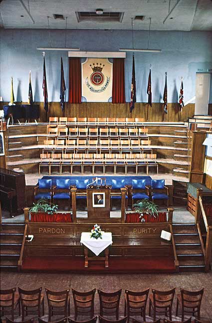
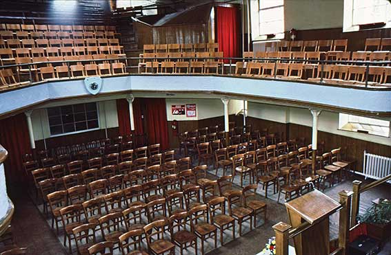
Above: photographs of the interior of the Tacket
Street Salvation Army Citadel, courtesy Morvyn Finch, to whom our
thanks. The galleried hall with its cast iron pillars bears striking
resemblances to others in the town, e.g. the nearby Christ Church URC and Museum
Street Methodist Church.
See our Christ's
Hospital School page for its move from Foundation Street/School
Street to Over Stoke.
See also our Historic
maps page.
Home
Please email any comments
and contributions by clicking here.
Search Ipswich
Historic Lettering
©2004 Copyright
throughout the Ipswich
Historic Lettering site: Borin Van Loon
No reproduction of text or images without
express
written permission