Museum
Street / Seckford's 'Great Place'
 2015 image
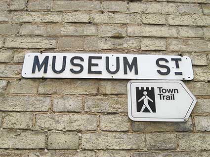
15 Museum Street, with its very attractive arched windows and
triangular pediments in Suffolk white brick, bears this street
nameplate: 'MUSEUM ST.'. One assumes that the
plate was removed during brick cleaning, then remounted using
edge-clips, as the plate bears no fewer than nine screw holes from
previous fixing. It is accompanied by a plastic Town Trail sign (does this still
exist?).
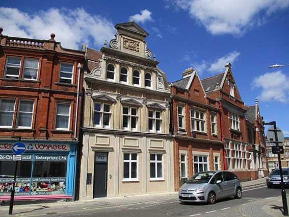
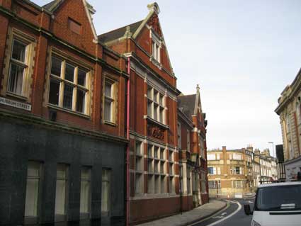
40-42 Museum Street
 2013 images
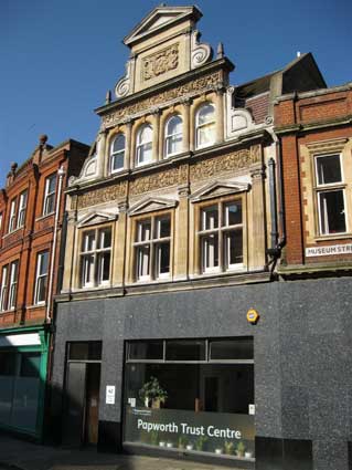
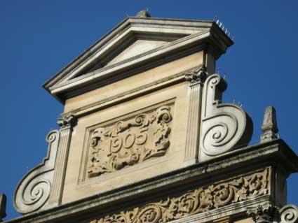
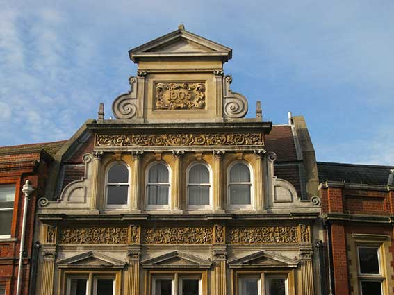
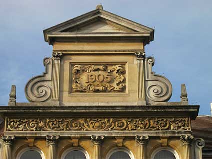
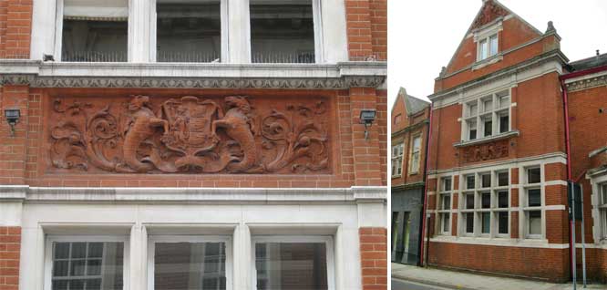
An even more decorative dated Edwardian frontage
with the prominent date amid Palladian and deco features, obelisks and
scrollwork:
'1905'
Ipswich Borough's Local List (see Links):
"42 Museum Street (Booth and
Mitchell coal factors and merchants)
The facade narrowing as it rises to a triangular pediment is based on
Italian Renaissance churches. Decorative bands of intertwined plants
are set between the fluted Ionic pilasters on the first floor and the
pilasters on the second. On the first floor the panels are divided by
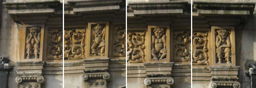
devils/leprechauns in the metopes above the pilasters. 1905 in the
cartouche under the pediment." Bettley/Pevsner (see Reading list) credit this building to T.W.
Cotman, who was also responsible for the Chelsea
Building Society building further up Princes Street, The Crown and Anchor and Lloyds banking
house on Cornhill.
Thomas William Cotman
(1847-1925) trained at Ipswich Art School and set up an office in
Cutler Street in 1869, then at 7 Northgate Street in 1883. He designed
buildings mainly in Ipswich and Felixstowe, having retired there in
1913. See our Felixstowe page for more on
Cotman.
John Shewell Corder,
probably the best known local architect of the early 20th century,
designed 40 Museum Street, a two-storey office building in 1922; red
brick with stone dressings, occupied for a time by the Halifax
Building Society. For more on Corder, see our Ancient House and Scarborow pages.
 2016 images
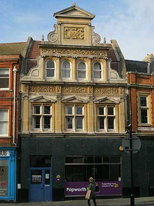
A late October morning in 2016 with the sun low and raking shows this
facade to great effect.
Mention of the 'devils/leprechauns in the metopes above
the pilasters' in the Local List description prompts us to look more
closely at these amusing
grotesques, not noticed by many passers-by:
[UPDATE
13.7.2024: 40-42 Museum Street has been sensitvely refurbished; the
most notable change is the removal of the grey mineral cladding which
was installed on both addresses by the Halifax Building Society on its
branch. The new owners have fitted out large, irregularly-shaped rooms
as apartments across both interlinked interiors.]
 2024
image
2024
image
38 Museum Street
Incidentally, a few doors down Museum Street can be seen a large
terra cotta version of the Ipswich
coat of arms.
The above buildings are former Customs and Excise
Offices. Customs and Excise were only combined in 1909, which must be
the date of the present building. The coats of arms serve as a reminder
that it was a National Service but that this branch was based in the
Port of Ipswich. Customs and Excise was merged with the Inland Revenue
in 2004.
The porch
of number 38 Museum Street next door displays a large British royal
coat of arms in stone. The Public Sculpture of Norfolk & Suffolk
database (see Links) tells us:
"On the royal coat of arms: DIEU ET MON DROIT and HONI SOIT QUI MAL Y
PENSE.
The curved pediment of the doorway is decorated with a striking royal
coat of arms with a fierce lion."
See also our Princes Street page
for the Frasers building which takes up much of the other side of the
road here.
Nearby in the pavement is an interesting coal-hole cover. Thick,
obscure glass segments are set into a cast circular cover with the
relief lettering:
'HAYWARD BROTHERS PATENT
SELF-LOCKING
UNION STREET BOROUGH LONDON'
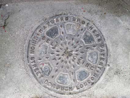
Founded in 1848, Hayward Brothers was a leading
manufacturer of this
sort of cast street furniture and was London’s largest manufacturer of
coal-hole covers when every household burnt the fuel for heating and
hot water. The company ceased trading n the 1970s. The introducton of
pavement lights was designed to
shed borrowed light into the cellar; see our Cornhill
page for an example of pavement lights on the former Grimwade's store
threshold.
Reference: 'The ultimate manhole covers site', see Links.
See also our Lettered castings
index page.
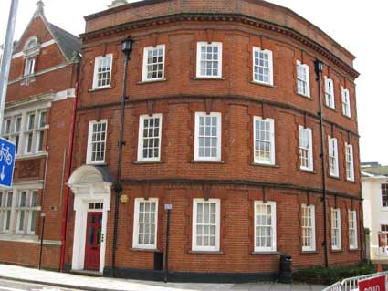
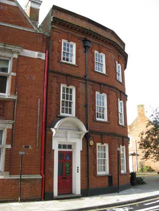
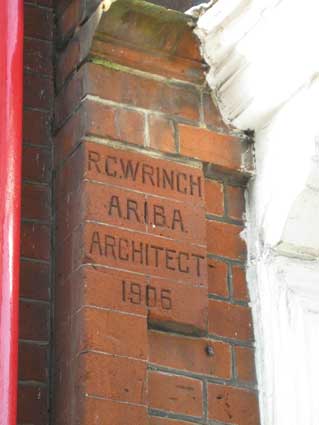
The 'R.C. Wrinch' lettering, 36
Museum Street (as it turns into Elm Street)
These characters cut
into the red brick exist somewhere around this Princes Street / Elm
Street / Museum Street. Contributor to this website,
Mike O'Donovan, included this intriguing image with others nearby in
2008, but he couldn't recall where he had found it.
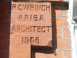 (photograph
courtesy
Mike O'Donovan)
(photograph
courtesy
Mike O'Donovan)
'R.C. WRINCH
A.R.I.B.A.
ARCHITECT
1906'
We walked around the whole area
and couldn't identify the lettering, so left a request for information
on this site. In November 2013 another friend of this website, Dr James
Bettley (who had been working on an update of the Suffolk Pevsner volume, see Reading list) tipped us off that
the lettering was at 36 Museum Street. However, even knowing the
address, it isn't easy to spot. Working from a long shot of the corner
building on Museum Street and Elm Street
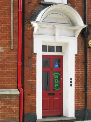
to the specific doorway...
... and there it is. Like a painter signing the corner of a
canvas, or a sculptor inscribing the base of a sculpture, R.C. Wrinch,
Associate of the Royal Institute of British Architects, took the
trouble to have the Suffolk reds chiselled out with condensed capitals,
replete with delicate full stops.
 2013 images
This red brick three-storey office building in
Edwardian classical style was commissioned by Walter Turner.
John Norman sends this additional information:-
Raymond Cyril Wrinch was the
son of the one time Mayor of Ipswich, Alfred Wrinch, ironmonger and
manufacturer of wrought iron garden furniture. Raymond was an architect
and Associate of the Royal Institute of British Architects, 1901 who
lived in his father's house:
Hillcrest, Paget Road; but from 1904 practiced from 16 Museum
Street. He was articled to E.F. Bisshopp in 1895, chief assistant
in 1900 and then on his own when he had qualified by 1901. He is
credited with the Museum Street/Elm Street building on which his name
is carved.
He also designed the Saw Mill for his father's works in Portman Road
(later destroyed by fire) and St Helen's School in Woodbridge Road
which
was built by Marriott's in 1913/14; probably the largest
primary school in Ipswich when built. See our V.A. Marriott page
for more on the school, although it doesn't appear to bear any lettering.
Another 'signed' building by R.C. Wrinch,
although perhaps more modest in conception, can be
seen in Kemball Street: 'Gordon
Terrace',
as shown on our Named buildings page.
Another 'signed' building similar to 36 Museum Street is the nearby
Britannic House
in Princes
Street (where you can also find the dated former
Fraser's building on the other side of Museum Street).
Further up Museum Street is
the Weslyan Chapel, with a lettered
foundation stone, also the junction with Arcade
Street.
Our Ipswich Museum page features the
original museum building (now Arlington's restaurant) which gave its
name to this street.
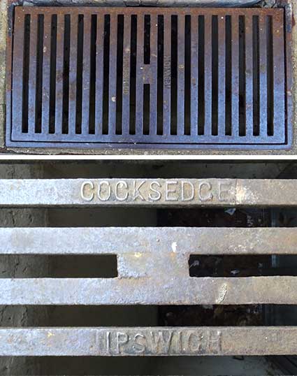
32 Museum Street
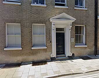 2022 view from the road
'I spotted this today [March 2023] outside 32
Museum Street. It seems to cover a basement skylight: the others along
the road have been replaced so this is possibly the last 'Cocksedge'
one here. Sandy Phillps.' See our Cocksedge
page for links to more of Sandy's ground-level finds.
The grating certainly looks as if it provides borrowed light to the
sub-basement rooms; the lintel brickwork above the windows can just be
seen at pavement level.
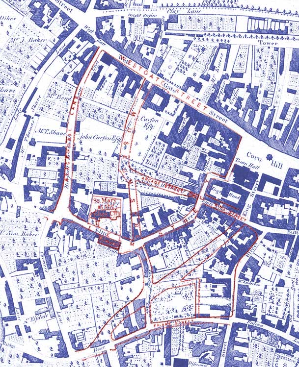
Comparative maps of the Museum Street
area
Below: a detail of the 1778 Joseph Pennington map of Ipswich.
- The 'Weft Gate' is at the upper left, with Lady Lane running south from the outside of
the medieval town boundary and 'Burftall or Gaol Lane' (today's Black
Horse Lane) running south inside it. The 'Gaol' which had once been
part of the actaul West Gate building had, by 1778, been rebuilt as a
separate building at the north-east of Gaol Lane (clearly labelled).
- The line of The Town Rampart was just north of 'Tower
Ditches' (the west part of today's Tower Ramparts) and photographs show
houses built up on the earthen ridge with a 'carnser'
giving pedestrian access to the front doors. The rampart ran accross
'Bull Gate' and across where buildings are shown, curving to the West
Gate, then southwards down the east side of Lady Lane.
- 'Clay Lane', at the top of the map detail, runs from the
area we still call, rather mysteriously, 'Hyde Park Corner' to the east
on the line of today's Crown Street.
- Working from the West Gate westwards. we see 'Bull Gate'
(now the widened southernmost portion of 'High Street') linking to Clay
Lane and there is no other north-south thoroughfare down the length of Westgate Street and Tavern Street until we reach 'Tower Lane'
(today's
Tower Street). There is no Providence Street, nor Lloyds Avenue, but
Mumford's Court (illustrated on our Cornhill
page) ran as a narrow passage through the buildings to the north-west
of Cornhill. The Market Coss is clearly marked on Cornhill.
- Thomas Seckford's 'Great Place' stands as a square
structure on the south side of Westgate Street below the word 'Gate'.
The garden in 1778 bears the legend 'J. Curfon Efq.'.
Scroll down for more on this mansion.
- Between Butter Market and
Tavern Street shows 'Cook Row'
(today's Dial Lane) and 'Fruit Market' (today's St Lawrence Street) on
either side of the Church of St Lawrence.
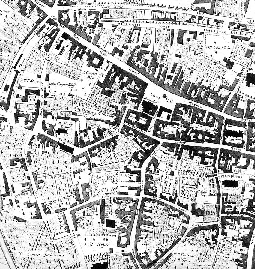 1778 map
Below: a similar area, as shown on a map of 1902. The differences are
striking – as highlighted by the coloured comparison of the two maps
below.
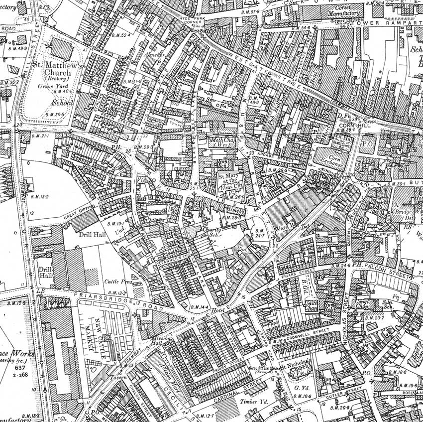 1902
map
1902
map
In 1902 Elm Street runs, as today, from the
top of Curriers Lane, past St Mary-At-Elms, across Museum Street, and
continues past the junction of Arcade Street and King
Street and north into the Golden Lion yard. Presumably the (unlabelled)
Lion Street was
considered to be the remaining alleyway leading round onto Cornhill.
Below: overlaying the outline 1902 map (in red) over the 1778
map (in
blue) indicates the radical changes to the streets here. Features which
stayed the same or similar are: 'Burstall or Gaol Lane' (today's Black
Horse Lane), Elm Street (slightly truncated in 1778), also the Church
of St Mary-At-Elms .
'Little King Street' (today's King Street – south of the
King's
Head) is about twice as wide, taking back land from the King's
Head site. From there we see major changes.: 'King Street' to the east
of the Town Hall becomes the first part of Princes Street. From the
junction with Butter Market south-westward, Princes Street chops through
houses
and gardens to reach 'Boat Lane'/Friars Street.
Museum Street cuts
southwards from Westgate Street through part of Seckford's 'Great
Place', through gardens to reach the original Museum building (today's
Arlington's Restaurant). Arcade Street continues the
cut through gardens and through the building on Elm Street we see today
with the arch. Later, Museum Street was continued southwards,
crossing Elm Street to follow the line of Thursby's Lane to reach the
new Princes Street. The small dog-leg of today's Coyte's Gardens
indeed
cuts through the physic gardens of Dr Coyte (and before him, Dr
Beeston).
All of this area changed again in the 1970s, of course, with the
building of the Willis, Faber & Dumas offices, as shown on our Lost trade signs page under the heading
'Before Willis'.
 1778/1902
comparison maps
1778/1902
comparison maps
The construction of Museum Street
Museum Street was constructed in 1847, the same year as the original
Christopher Fleury-designed Ipswich Museum.
It turned sharply to the east just past the pilastered Museum building.
In 1850 an archway was cut through the house which had been occupied by
Lincolnshire banker William Ingelow from 1834 to 1844 (also his
daughter, the novelist Jean Ingelow – see our Blue
plaques.) The archway enable the road to link into King Street at
the junction with Elm Street. When in the 1850s a junction was made
between the southern end of Museum Street and Thursbys Lane (the
awkward junction between the two sections of Museum Street is explained
by this afterthought in street planning), the eastern leg of the
original Museum Street was renamed Arcade Street. The name Museum
Street was then applied to the whole street from Westgate Street to the
new Princes Street. See our Princes Street
page for a timeline of the piecemeal building of that curious
thoroughfare linking Cornhill to the railway station. The small
southernmost section of Thursbys Lane which remained between Princes
Street and Friars Street was finally swept away with the building of
the offices of Willis Faber & Dumas in the 1970s.)
[Information from Malster, R.: A
history of Ipswich, see Reading List.]
Seckford's 'Great Place'
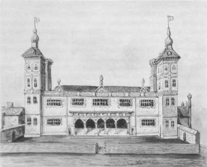
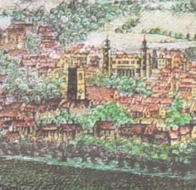
Above: Seckford's
Great Place on the south side of Westgate Street and as shown behind
the church of St Mary-At-Elms on a 1741
Prospect of Ipswich.
Thomas Seckford (1515-1587) was an official at the court of
Queen Elizabeth I. Elizabeth is known to have held
court at the Seckford family seat, Seckford Hall. It is
difficult to imagine the rather workaday, slightly run-down, westerly
part of Westgate Street as playing
host to such a grand, towered
mansion as 'The Great Place' (also known as Seckford House) with
beautiful gardens laid out behind it in1574. But then
Ipswich
at that time was known for the many gardens and orchards in the town
centre; see also Coytes Gardens. You
will have walked up one of the staircases from The
Great Place if you have ever eaten at the upper restaurant area in
Arlington's, the original Ipswich Museum.
“A large site on the south side of Westgate Street and just
within the gates, was chosen by Thomas Seckford, a cadet of the
old-established Seckfords of Seckford Hall [on the outskirts of Woodbridge] , for the erection of his
“great house” in this town. Seckford was Member of Parliament for the
borough and as Master of the Court of Requests was a frequent adviser
to the corporation. He had amassed a fortune in his busy life as
Surveyor of the Court of Wards and Liveries and extolled the virtues of
industry in the mottoes used upon maps made at his cost by Christopher
Saxton for the first county atlas of England. His Ipswich mansion with
its curious cupola-like turrets overtopping the houses around, passed
to two of his brothers, both deeply engaged in privateering, although
the one was Master of the Tents to Queen Elizabeth [I] and a groom of
her chamber.” (From Redstone, L. Ipswich
through the ages, see Reading list.)
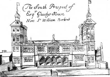 1674 view
'Squire Gaudy's House': Ogilby's map shows the house a
hundred years after it was built, captioned 'The South Prospect of
Esqr. Gaudys House, Now Sr. William Barkers'. The two views shown here
are looking from the gardens to the south. The
house suffered considerable change before its eventual
disappearance when Museum Street was built in the mid-19th century (as
described above).
See also Lost
Ipswich trade signs for
'Before and After Willis'
Related pages
Cornhill
1, Cornhill 2
King Street / Arcade Street /Lion
Street
Crown & Anchor / Westgate Street
Lady Lane,
Civic Drive
Salem Church / St
Georges Street
Princes
Street
Friars Bridge Road
Coytes Gardens
Museum Street
Methodist Church
Black Horse Lane
Ipswich
Museum
Street nameplates
Historic maps
Street index
Street name derivations
Home
Please email any comments and contributions by clicking here.
Search Ipswich
Historic Lettering
©2004 Copyright
throughout the Ipswich
Historic Lettering site: Borin Van Loon
No reproduction of text or images without express written permission