County Hall / County &
Borough Gaols
The white brick and stone castellated building which
dominates the town
end of St Helens Street is called today 'County Hall'. It contains the
law
court which once granted the decree nisi in the divorce of the
notorious
Mrs Wallace Simpson from her first husband, freeing her to marry the
future
king, after his succession to and abdication from the throne as Edward
VIII
in 1936. The Suffolk link continued when Mrs Simpson laid low in a
house
on Undercliff Road, Felixstowe to avoid the media and public outcry
surrounding
her affair with the future Duke of Windsor, both of them destined for
exile
in Paris until their deaths. However, the Ipswich Gaols (see below)
which stood behind County Hall have a longer history.
East Suffolk County Council, St Andrew
House, St Helens Street
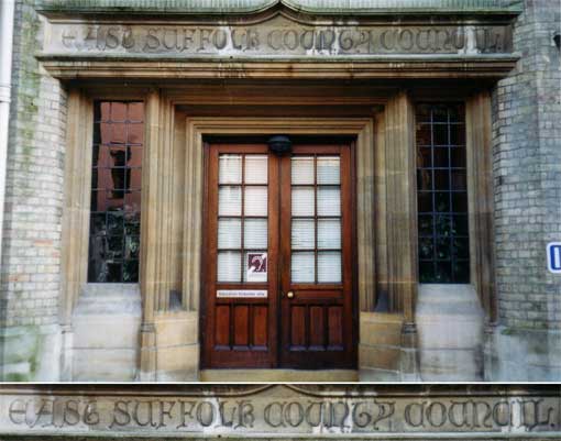 2004 image
St Andrew House, an unattractive 'add-on' block which
runs behind the terrace
of small shops in St Helens Street, with an side-door onto Grimwade
Street
has an entrance in keeping with its surroundings to the left of the
archway
leading into the County hall car park. Above the double doors is
carved:
'EAST SUFFOLK COUNTY COUNCIL'
The old split in administrative areas of
East and West Suffolk is commemorated here; they were amalgamated in
1974 to
form
one large shire county. Ipswich Corporation (County Borough) lost many
of its responsibilities as a result. For more information, scroll down
to 'County Hall through time'.
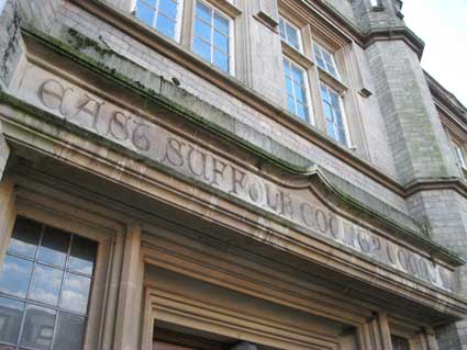 2014
image
2014
image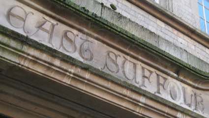
After years of closure, vandalism and neglect of County Hall, this
forgotten entrance suffers only from moss and algae in 2014. By 2015 St
Andrew House was converted to residential use and renamed Anton House.
[UPDATE 21.10.2016: "I am a
member of the Milestone Society with a particular interest in boundary
markers. I know that your group mainly covers Ipswich (your website is
fantastic and I can't wait to study your boundary marker page and then
visit the town) but I wonder if you might know of the whereabouts of an
East Suffolk boundary sign image please? This has become a frustrating
quest for me although my enquiries did run a West Suffolk sign to
earth. It came from Mildenhall last Friday. The owner’s father worked
for Suffolk Highways in 1974 and saved it from a skip. Mike Bardell"]
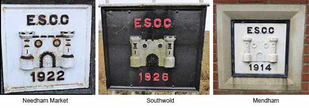
In January 2017,
we discovered a set of 'East Suffolk County Council' signs on a bridge
on the edge of
Needham Market. Below are further
examples provided by Mike Bardell (to whom our thanks) from Southwold and Mendham, all dated within a
twelve year time bracket (1914, 1922, 1926).
Below:
Mike's
'West Suffolk' sign.
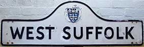 Photographs
courtesy Mike Bardell
Photographs
courtesy Mike Bardell
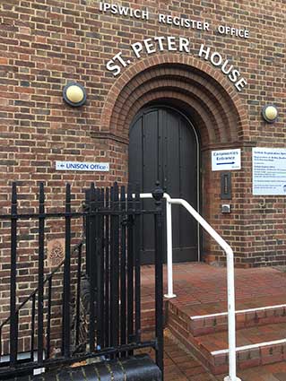
Rope Walk
Before moving away from this end of County Hall, it's worth a look
round the corner in Grimwade Street and Rope Walk. This area was
developed as a sort of County Council campus with, in Rope Walk, St
Edmund House (now residential), the NALGO Staff Club, St Paul House
(Social Services HQ, now demolished) etc. In Grimwade Street is St
Peter House, once a Labour Exchange, now the Register Office. Before
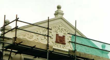
the Staff Club was demolished in 2016/17, we took these photographs of
the frontage showing the East Suffolk County Council coat of arms. East
Suffolk, along with West Suffolk, was created in 1888 as an
administrative county of England. The administrative county was based
on the eastern quarter sessions division of Suffolk. East Suffolk
County Council's headquarters were at East Suffolk County Hall in
Ipswich, which was a county borough in its own right. In 1974, most of
the county reunified with West Suffolk and the County Borough of
Ipswich to form the non-metropolitan county of Suffolk. A small part of
East Suffolk moved into Norfolk during the 1974 reorganisation.
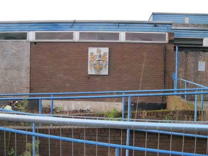
 2016 images
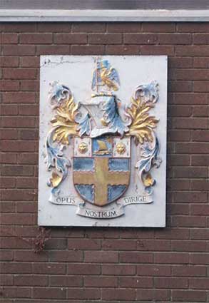
Official blazon
Arms: Sable a Cross engrailed
Or on a Chief Ermine between two Leopard's Faces of the second a pale
Azure thereon upon Waves of the Sea proper an ancient Galley to the
sinister sail set and issuant from the sinister chief the Sun in
Splendour also of the second.
Crest: On a Wreath of the
Colours upon a Rock proper a Falcon belled wings expanded Or the inside
of the wings Azure supporting with the dexter claw a Staff erect also
proper flying therefrom a Banner also Azure charged with a Garb Gold.
Motto: 'OPUS NOSTRUM DIRIGE' -
Direct our work
Origin/meaning
The arms were officially granted on December 14, 1935.
The cross is from the arms of the Uffords, ancient Earls of Suffolk,
and the leopards' faces are from the arms of the de la Pole Earls and
Dukes of Suffolk. The galley represents a Viking ship in token that the
County is peopled largely by descendants of the Norsemen, and the
rising sun denotes its easterly situation. The crest is a differenced
form of the badge of Charles Brandon, Duke of Suffolk.
The motto is a contraction of the Vulgate text, "Opus manuum nostrarum
dirige".
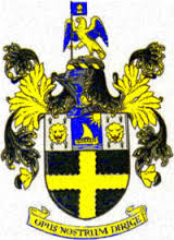 East Suffolk County Council coat of arms
See also our page on Ropewalks
for an ancient industry in this part of Ipswich.
Grimwade Street
Many thanks to Tony Marsden for the photographs of St Peter House (and
for spotting the lettering). The terra cotta plaque is set so low down
to the left of the door onto Rope Walk, in the position normally
occupied by a foundation stone, so is easily missed:
'GVR
1934'
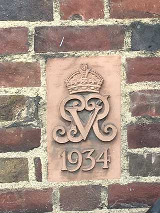 Courtesy
Tony Marsden
Courtesy
Tony Marsden
George V (George Frederick Ernest Albert, 1865-1936) was King of the
United Kingdom and the British Dominions, and Emperor of India, from 6
May 1910 until his death in 1936. In November 1891, George's elder
brother Albert Victor had become engaged to his second cousin once
removed, Princess Victoria Mary of Teck (known within the family as
"May", nicknamed after her birth month). But Albert Victor died of
pneumonia in 1892, leaving George second in line to the throne, and
likely to succeed after his father, King Edward VII. Queen Victoria
still regarded Princess May as a suitable match for her grandson, and
George and May grew close during their shared period of mourning. A
year after Albert Victor's death, George proposed to May and was
accepted. They married on 6 July 1893 and the monogram may relate to
their reign 'George, Victoria, Rex/Regina' which continued until two
years after this building was dated. However, another explanation after
all that complex royal succession research, is that it is George V Rex.
County Hall,
St Helens Street
 2004
images
2004
images
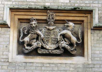
Further down the street towards town is a crest in deep
relief with lion
and unicorn rampant; 'Dieu Et Mon Droit' ('God and my right') is carved
on the lower scroll and, we think, 'Honi Soit Qui Mal Y Pense' ('Evil
be
to him who evil thinks') on the circular band surrounding the shield.
This
probably harks back to the building's legal past. Of course, the listed
part of the building with its castellations and towers fronting onto St
Helens Street is known as the home of Suffolk County Council. That is,
until
March 2004 (when these photographs were taken); starting from that
date,
most of the S.C.C. departmental headquarters were moved to Endeavour
House
in a large glass building between the football ground and the River
Gipping.
Built for the failing power company TXU-Energi, Endeavour House was
snapped
up by the County and a period of fitting out and logistical planning
resulted
in the evacuation of County Hall. Placed on the market, the huge
fortress
of municipal power once bore a small estate agent's 'For sale' board on
the
corner
of Bond Street.
In 2012 it remains a sad sight, vandalised and redundant. From the BBC
Suffolk website: 'A former jail in Ipswich has been put on the
Victorian Society's list of 10 most endangered buildings. The
organisation said County Hall had fallen into disrepair after being
sold by Suffolk County Council in 2004. It said the Grade II listed
building was "designed to instil awe" but now "inspires pity and anger"
after being over-run by "drug users and squatters".'
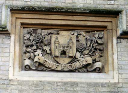
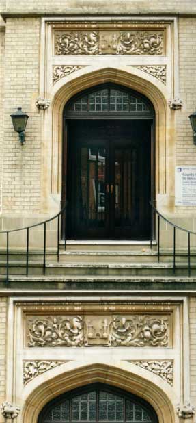
This attractive panel further down the facade is close
to and opposite The
County Hotel, extensively refurbished in March 2004 (see below). That
landmark
public house also carries a castle motif in the centre of its front
gable.
The example above proudly proclaims:
'SUFFOLK'
on its scroll and has
the
air of fairytale about the turrets and portcullis. Stone roses,
tendrils and foliage surround the central shield.
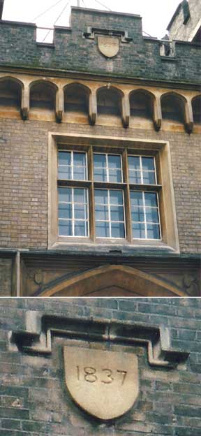
High up near the faux battlements of County Hall is a
simple
shield with it own sheltering stone moulding. It bears the date of '1837': probably a bit
earlier
than many of us would have guessed. The inset enlargement makes this
clearer,
but it's rather an insignificant announcement of the massive
structure's
date of building.
And just for completeness: the remaining decoration, here surrounding
the
former St Helens Street pedestrian entrance to County Hall. In the
centre, another small castle. We have seen a cast iron bridge plate for
'E.S.C.C.' dated 1922 and it shows a castle entrance very similar to
that shown below with two castellated towers, two windows and a central
entrance with portcullis. This suggests that the whole of County Hall
was really the home of East Suffolk County Council and became the main
offices and chamber of Suffolk County Council once East Suffolk, West
Suffolk and Ipswich County Borough were amalgamted in 1974.
See our page on Public
clocks in Ipswich for a 2018 view of the County Hall clock and
tower.
County and Borough Gaols
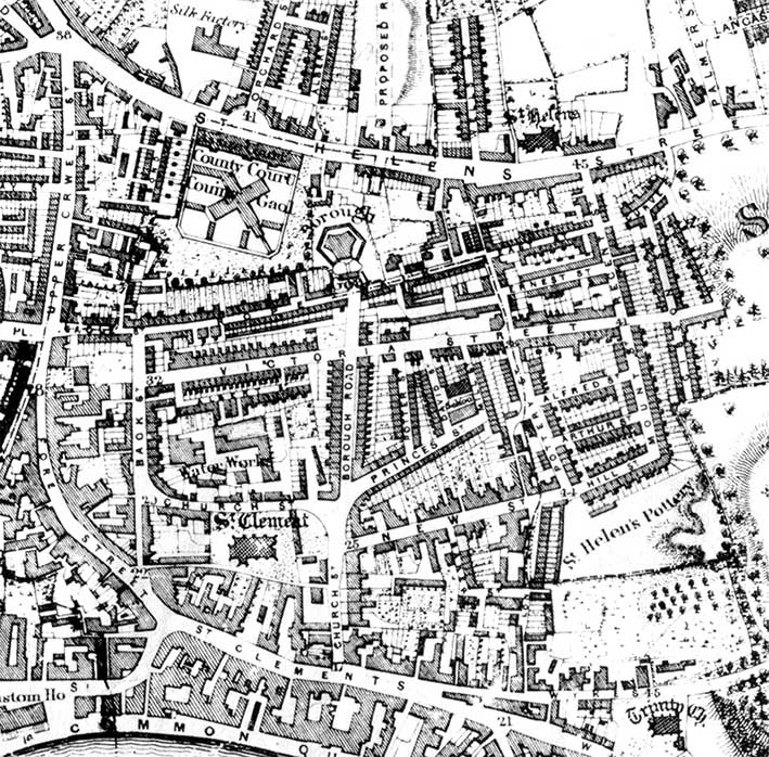 1867 map
Although the legends on the Edward White map of 1867 are rather
cluttered and overprinted, we can decipher:-
1. On the row of buildings fronting St Helens Street: ‘Assize Court’;
this would be the structures we know today as ‘County Hall’ (dated
1837, thirty years earlier) sitting opposite the half-circle junction
at Orchard Street, still to be seen outside The County Hotel. Just
north-west of this is a ’Silk Factory’, the site of today’s modern
development, Silk Street.
2. Immediately south of this, the X-shaped blocks have ‘County Court’
above and ‘County Gaol’ across the centre. This group of buildings
appears to be walled with 45 degree-angled corners to the south.
3. East of the County Gaol is the ‘Borough Gaol’ boasting another
unusually-shaped set of buildings including most of a hexagon; they
appear to front Rope Walk with the jaws
of Borough Road, later Grimwade
Street, opposite.
4. North of this is labelled ‘Proposed Road’ which would become today’s
Argyle Street with its Ipswich Board School
and ‘Harry Seaman’ sign.
This would eventually run across St
Helens Street and cut through the
middle of the Borough Gaol site to link with Borough Road, forming
today's Grimwade Street. To the east
is Wells Street (the site today of Wells Court flats) which runs
parallel with St Helens Church Lane, the narrow line of which, running
north past the church to Woodbridge Road, is unchanged today.
5. The density of housing in ‘The Potteries’
is seen clearly with many
roads unrecognisable today:-
Rope Walk continues into East Street and Curve Street (all now called
Rope Walk) to join St Helens
Street;
Dove Street doesn’t appear at all, apart from a narrow alley which runs
down into Pottery Street, leading in turn to "St Helen's Pottery";
Ernest Street, Alfred Street, Arthur Street and Hill Street are roughly
parallel and run between Pottery Street and Mount Street / Regent
Street (a small part is still visible today) with "St Helen’s Pottery"
clearly
labelled with the clay hills edging the grounds of Upper Hill House
(today’s Alexandra Park) being dug
into to produce tile and brick;
Milner Street is still there, dropping south from Curve Street, but
Gibson Street has gone;
The long east-west Victoria Street, quite a thoroughfare by the look of
things, has gone;
South of Victoria Street is, inevitably, the smaller Albert Street,
Potter Street, David Street, Mills Street, Princes Street, New Street
and Baker Street (all now gone);
Just readable is ‘Long Lane’ part of which today runs from the bottom
of ‘Wykes’ (Wykes Ufford Hamlet, today’s Back Hamlet) into the
university site – the ‘Long Street building’ still stands behind the
Congregational Church.
The east-west section of today’s Fore Street (from about The Lord
Nelson to Duke Street) is labelled ’St Clements’ with Church Street
running north on the line of today’s Grimwade Street with the Captain’s
Houses, but curving round the churchyard to the west to turn north
again and become Back Street. Today this is Star Lane and Waterworks
Street respectively, indeed
the ‘Water Works’ are clearly
labelled with the reservoir visible above
the legend.
See The Potteries page for a 1902 map of the
same area extending west to Cox Lane.
See our Courts & yards page for more
information.
County Hall through time
Top: The
County Gaol, St Helens Street, Ipswich (mid-19th century?) by
Claude Lorraine Richard Wilson Nursey (1816–1873) [Colchester and
Ipswich Museums Service: Ipswich Borough Council Collection, ArtUK];
Centre: Hand-tinted postcard of St Helens Street, c.1905; the
foreshortening here is deceptive: the double-fronted building at left
still stands today – the space to the right of it doesn't look big
enough to accommodate the 1926 extension;
Bottom: St Andrew House and County Hall, 2024. Photograph by Lisa
Wall.

The bottom photograph shows how the original County Gaol/Hall was
extended eastwards incorporating an arched gated entry and the 'East
Suffolk County Council' pedestrian entrance. The design by H. Munro
Cautley features on the architect's watercolour drawing held at Suffolk
Archives (HG400/2/246/3),
dated September, 1926. The ground floor in 1926 featured shop-fronts
either side of the central door – as it is today. Cautley's lettered
entrance was
linked
to a more modern block behind it, which has since been converted into
accommodation called 'Anton House'. The main bulk of County Hall has
been abandoned, empty and badly damaged by vandals, pigeons and the
weather since 2008. Historic England has categorised County Hall as a
'Building-at-risk'. In 2024 there may be a glimmer of hope that the
building, Listed Grade II, can be converted for a new use.
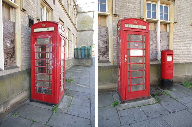
K6 telephone kiosk
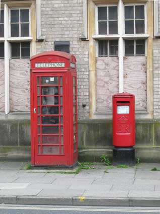
The classic pairing of a (ER II, modern) pillar box and a K6 telephone
kiosk outside the County Hall entrance archway. As far as we know, this
is the only K6 with a regularly working telephone in the town. See one
from the
past ouside The Greyhound pub on our Street
furniture page (with a link to photographs of its removal); also a
vandalised K6 next to Stoke bridge
which sometimes has a working telephone, but no door.
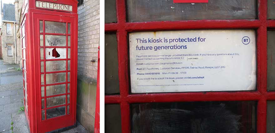
[UPDATE 30.9.2025: 'The Death
Of A K6?' This poor, benighted telephone box is looking very sad.
 2025
images
2025
images
The sign stuck inside the box reads:
'This kiosk is protected for future generations
Payphone services are no longer provided from this kiosk. If you have
any questions about this, please contact us quoting the reference...
... If you would like to adopt this kiosk, please visit ...'
So, it is protected for future generations by removing the telephone,
adding a lock to the door and leaving it to the slings and arrows of
outrageous fortune. Grafitti spray has been roughly cleaned off, but
the plastic 'windows' are being attacked. The vandal(s) will, no doubt,
revisit this easy target. A sad sight.]
The County Hotel
On
the opposite side of St Helens Street The County Hotel underwent
thorough
renovation in May, 2004 at the hands of Suffolk brewers, Adnams (the
castle
motif repeated near the apex of the palladian-style frontage). This
castle was resplendantly picked out in gold and the walls painted
mouth-wateringly
mid-blue with white details on the so-called 'Gastrobar' (ahem!).
Again, after closures and reopenings, this
building was boarded up in 2012.
 2004 images
[UPDATE 17
October 2012. The Victorian Society website
(see Links) featured this complex of
buildings under the heading A town's
shame:-
"Built in 1836-37 by W McIntosh Brooks, Ipswich’s Grade II County
Hall was once the area’s gaol and law court. Following extensions
for council offices in 1906 by JS Corder [see also his work at Scarborrow] and Henry Miller, it then became
the headquarters of East Suffolk County Council.
A building initially designed to instil awe, then inspire with civic
pride, it once boasted fine wood panelling and stained glass windows.
It now inspires only pity and anger.
For years, following its sale to a private owner, it has been the haunt
of vandals, thieves, drug-users and squatters. Copper and lead have
been stripped, letting water flood in; much of the panelling has been
vandalised. The glass on the clock tower has been kicked out leaving
the clock mechanism to rust in the rain.
What went wrong?
'This is a case of a sloppily worded agreement that left the owner free
to neglect a historic building,' said Chris Costelloe, the Society's
Director. 'County Hall was sold to a private owner. In return for
permission to build flats on adjacent land, the council was supposed to
get the owner to develop and protect the historic building. This didn't
happen. Security measures have clearly been inadequate.'
Chris adds, 'We see this situation too often; it's especially
reprehensible when it occurs to a fine civic building in one of our
major cities.'
Here is a case for far-reaching, draconian, and most of all, urgent
action by Ipswich Council. Residents, taxpayers and elected
representatives should demand that such action is taken now. The
council should serve an urgent works notice to ensure the building is
made secure and emergency repairs are done."]
[UPDATE March 2013: What a
depressing
part of the town this has become. The County Hotel struggles on with
intermittent openings. County Hall may see a glimmering of a future use
for the complex if the Ipswich Building Preservation Trust can take it
on as their largest ever project. Add in the
long-blighted Upper Orwell Street with
its gaps, decaying empty shops and burn-out St Michael's Church (March
2011) and
the nearby Carr Street Co-op complex and one
wonders how, by the early twenty-first century, we ended up here...]
[UPDATE 20.5.2014: "There used
to be some nice modern aluminium lettering on both County Hall (St
Helen's Court) and St Edmund House including a very fine version of the
County Council's coat of arms. I know because I had them made and, when
the council moved, had them taken down! I hope they are in store
somewhere. I've got some photo somewhere I'm sure and will try to look
them out. They were made by Bill* Clarke (the wife of Geoffrey Clarke
the famous sculptor who's work still hangs high up at the corner of St
Matt's St and Berners St). ... When the County Library (as it then was)
in Northgate St was refurbished in the 90s I had her make cast
lettering signs for the entrances - as required by the planning
authorities. Someone took them down and (perhaps "illegally") replaced
them with inferior quality signs. – Rev'd Alan Forsdike" Our thanks to
Alan.] *N.B. Geoffrey married Ethelwynne Tyrer, known as Bill.
County Hall and St Helens Street
memories
The following recollections are taken from the 'Kindred Spirits'
column, in the Ipswich Evening Star,
1 September 2009
[http://www.ipswichstar.co.uk/news/grim_history_of_town_landmark_1_174934]
“Originally built as the county jail in the 1780s, it [County Hall] was
never intended to be a thing of beauty. At one time it contained a
treadmill, as a means of punishing [through long sessions of ‘hard
labour’] rather than providing exercise for the prisoners and when
needed, a set of gallows was erected behind its castellated walls. As
recently as 1926, well within my parents' lifetime, men were being
hanged within its walls for committing murder and one could still
detect a slightly dark and foreboding atmosphere around the place.
Overlooking County Hall was the County Hotel. Accommodation here would
have been in great demand during local murder trials and also of
course, during the famous divorce proceedings of Mrs Wallis Simpson,
then a Felixstowe resident, and later the wife of King Edward VIII
following his abdication. Between Grimwade Street and County Hall was
another row of shops, including a greengrocer's and florist's, which
had flowers in buckets standing outside on a low green wooden shelf;
and a furniture shop displaying highly-polished antique tables and
ornately upholstered chairs. There was also St Helen's post office,
which become another victim of the rush to kill off local post offices.
Opposite was a very large house, possibly a doctor's, which stood in
its own grounds well back from the road and the May Bush public house.
The latter closed in the mid 1960s and was taken over as a social club
by the Royal Air Force Association.”
Opposite the Gaumont is a sandwich bar. It was empty and in poor
condition some years ago, but was refurbished and the original beams
exposed. The date, 1636, had been
carved on one of the upper beams and the numerals would appear to be
original. A little bay protrudes from the first floor and above that is
a tiny dormer window. We may be able to describe the changes to St
Helen's Street during the last 50, 100 or even 150 years with some
degree of accuracy, but anyone looking through that window 373 years
ago would have encountered a very different scene. What they might see
in 373 years time?”
Shops east of County Hall
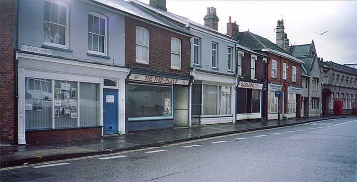 Courtesy John Bulow-Osborne
[UPDATE 29.1.2018: from John
Bulow-Osborne. County Hall 'East Suffolk County Council' offices at far
right; Suffolk Connexions (sorry about that) and SCC road safety
offices; G. Golding Family Butcher at no. 40 – empty; former St Helens
Street Sub-Post Office (the red pillar box on the pavement outside
stayed there for some time after closure); The Fire-Place at no. 44 –
empty and, finally, number 46: an empty shop used as local authority
offices. The Fire-Place and the shop to the left were demolished to
make
room for the corner apartment block. Photograph:
early to mid-1990s.]
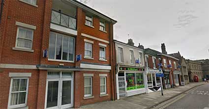 2016
image
2016
image
Below – John Bulow-Osborne: '46 St Helen's Street: rough mono image of
my grandfather and uncle, who ran a furniture shop there. My uncle took
over later.' John's photograph also shows that further shops extended
eastward in the early 20th century, before road widening at the St
Helens Street/Grimwade Street/Spring Road/Argyle Street crossroads. For
a period view of the corner Emeney's Newsagents see our H.W. Turner page.
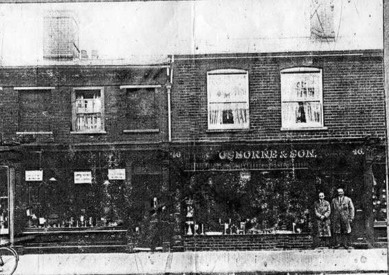 Courtesy John Bulow-Osborne
For more lettering
examples in
St Helens Street
try Hales Chemist, IBH, H.W. Turner and Tramway
Place. Also The
Regent on our porticos page.
Home
Please email any comments
and contributions by clicking here.
Search Ipswich
Historic Lettering
©2004 Copyright
throughout the Ipswich
Historic Lettering site: Borin Van Loon
No reproduction of text or images without express written permission