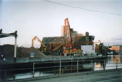
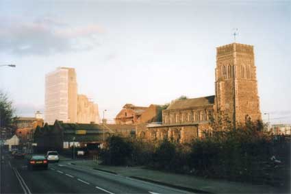
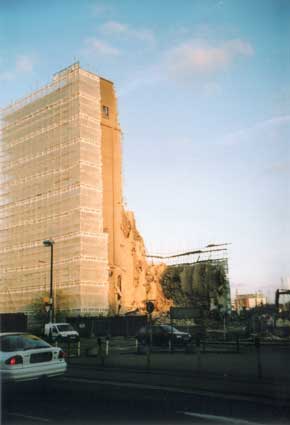
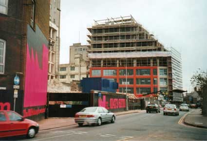
Early 2006
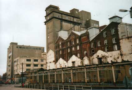
Looking up at the yellow-jacketed demolition workers at and near the top of the 1960s Wunderhaufen malting plant marked R&W Paul situated beside the Custom House, before it was shrouded in sheeting, revealed just how damnably big these things are (or were). The workers were like ants.
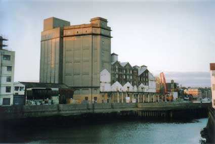
 [March, 2006]
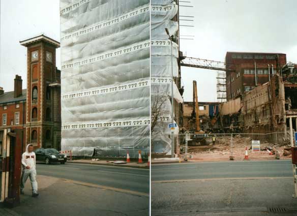
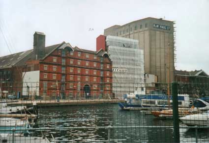
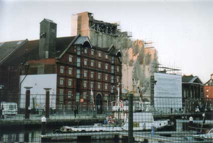
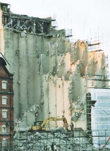
Above left: The
Italianate clock tower
on the corner of the Custom House, seen from the other side of Key
Street, is nearly obliterated by the R & W
Paul maltings clad in its falsework and plastic sheeting. This
extended around the corner and down the side facing the Custom House.
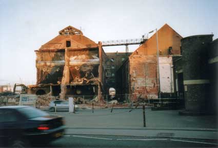
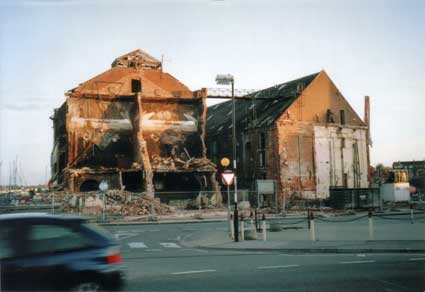
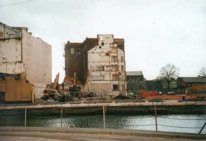
The demolition machines then nibbled away at the open sides, including
that facing the dockside to avoid any debris falling onto the road or
damaging the listed building. Above right is the view past the right
hand edge of the '777' cladding: a yawning void with one of the
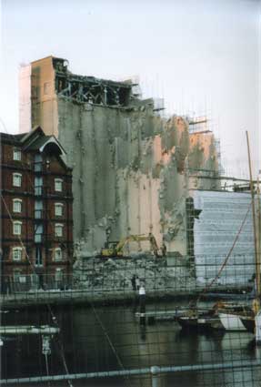
demolition cranes just prior to tackling the huge maltings. A pattern
emerged along the whole site of devastation surrounding carefully
selected parts of the buildings on the dockland site to be preserved
and developed - although not as
many of the latter as some of us had assumed before the whole operation
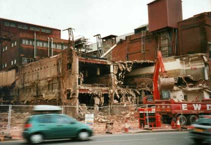
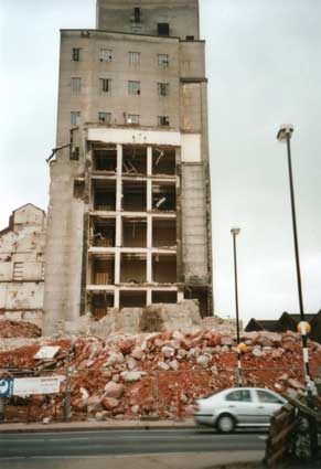
started. The third image, below, shows the typical ragged edge of half
demolished reinforced concrete boxes which became so familiar to
spectators. Indeed the dangling slabs and rods were rather a beautiful
on one of the huge half-eaten silos.
See also our page on Paul's maltings.
Fortunately for us, the archaeologists were able to carry out extensive digs in accessible areas in 2004/5 as this part of Ipswich was once the seething heart of the town dating back to the early Anglo-Saxon period. Indeed, revetments from those times were uncovered during the dig on the Cranfield's site indicating the original line of the quayside. It was also the home of one of the powerful religious establishments of the town: the Austin Cannons of St Peter & St Paul. The river level in earlier centuries (very pre-Wet Dock, 1842) was much lower and the river basin spread out; at the time of Wolsey's College the riverbank would have run up the centre of today's College Street, hence the presence of the surviving Wolsey Gate – the watergate of the college complex.
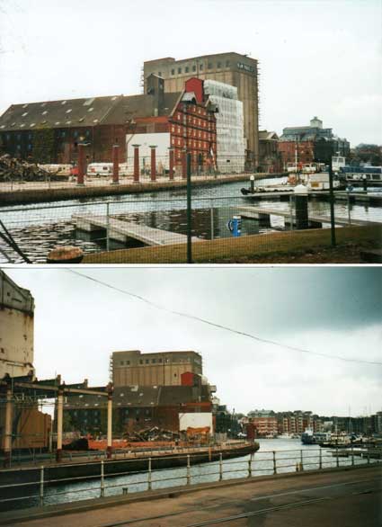
Moving round the site, past Burtons and St Peter's Church, the above photographs were taken from the Island between New Cut and the Wet Dock. Opening up views of the dockland churches for the first time, the demolition also stripped away the clutter, corrugated iron and prefab concrete which hid the original wharves. On the lower image we look eastwards down the quays to the flats near Neptune Quay. Henry Palmer's cast iron colonnade which carried Cranfield's Flour Mill over the dock on Albion Wharf to enable loading and unloading from ships in the dock. The upper photograph shows the further row of red coloured columns, now supporting nothing and awaiting the new structures.
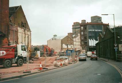
May/June 2006
The following photographs form an album of images taken during the major demolition and clearance period of the regeneration scheme.
For a view of the back of this building, with its central arched tunnel, during demolition see below.
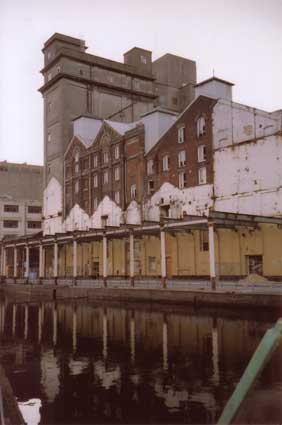
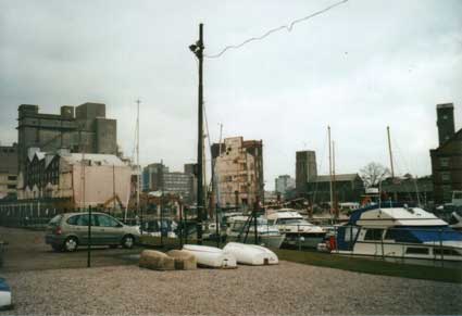
Above: a view of the northern quays from the Neptune Marina boatyard prior to the major demolition projects.
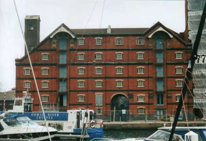
Above: watching it come down... The care taken by the demolition contractor is understandable with the proximity of the beautiful red brick building on Albion Wharf – yet another Paul's malting – and the Custom House (both visible in the photograph at left).
The close-up shows the lumps of concrete hanging from the reinforcement rods exposed during demolition. Presumably this feature made the piecemeal demolition process safer and ensured that heavy debris did not damage neigbouring structures.
Above left: a view of Albion Wharf from the island after the over-buildings were removed from the collonade. Above right: the Church of St Mary-At-The Quay exposed to view from the dock, possibly for the first time in centuries.
Above left: a view across the lagoon next to Stoke Bridge with buildings on St Peter's Wharf – the red brick Paul's maltings to the left (post fire), now demolished, the concrete Paul's silo, the white, soon-to-be butchered Burton's factory and the lower E.R. & F. Turner foundry buildings standing across Foundry Lane from the future site of The Mill/Jerwood DanceHouse. See our Trinity House buoy page for several more views of these buildings.
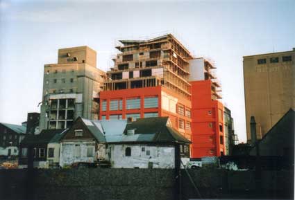
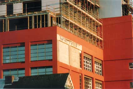
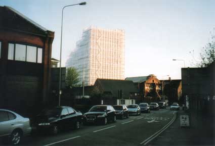
Above: the last of the Burtons lettering on the nascent, orange Cardinal Lofts block overlooking College Street.
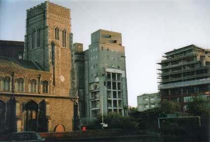
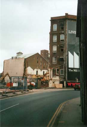
Above: the Church of St Peter at left with the scaffolded Cardinal Lofts block rising to the right. The central silo is on the future site of DanceEast and The Mill.
Above: the view of the shrouded Paul's silo next to the Custom House at left, the 'stump' of the red brick Cranfield's mill at right with St Mary-At-The Quay in the centre, seen from Star Lane. See that page for photographs of that part of Cranfields taken from inside St Mary-at-Quay in 2008.
Above: two views of the rear of the red brick wharf building from the tiny Slade Street (the point where Star Lane and Key Street almost touch). The photograph at the left shows the central archway; it also shows some curving grey brick buildings which have been demolished by the time of the photograph to the right.
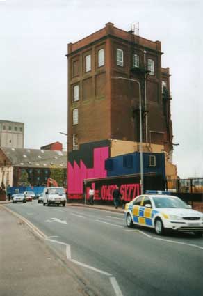
Above the spectral Paul's silo next to the Custom House part-way through demolition in the late afternoon sunshine, viewed from Star Lane.
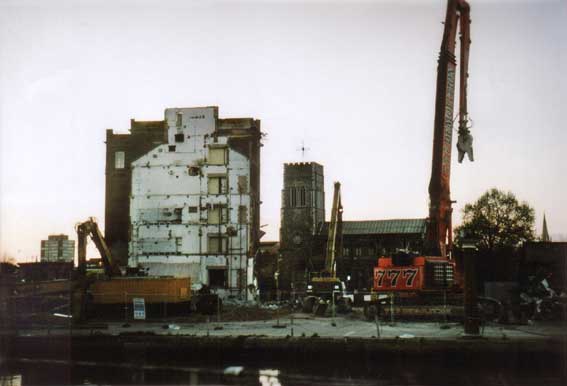
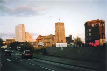
Key Street with the red brick gabled buildings at the right which once stood close to St Mary-At-The Quay, also the huge banner covering the Cranfield 'stump'. The next few shots follow Key Street into College Street with a view of the orange Cardinal Lofts block opposite the Wolsey Gate.
Above: the gap between the Cranfields stump and Cardinal Lofts became the site of The Mill tower block incorporating DanceEast. See those pages for further images.
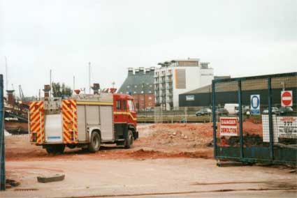
Below: apparently, a fire engine was required to be in attendance on the site throughout the demolition and clearance process. Felaw Maltings and the first modern block of waterside apartments (on Stoke Quay) can be seen across the dock and New Cut in the centre of the picture.
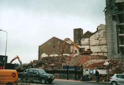
An impression can be gained of the enormous quantity of rubble produced during operations by the digger perched upon a sizeable mound (below).
Views from the Island before demolition of the gigantic silos to make way for the even more gigantic DanceEast tower known later as 'The Mill'.
Above: demolition clearance opened up the vistas both into and from the Wet Dock. Behind Cranfield's 'stump' is Church of St Mary-At-The-Quay, for decades screened off and dwarfed by heavy industry.
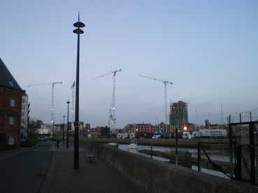
[UPDATE February, 2008: here we are on a late afternoon stroll round this (now) hub of construction and industry, rather than destruction. Below is the long shot from the Stoke side of the Gipping at high tide, with Stoke Bridge and the only surviving concrete silo – complete with 'R. & W. PAUL Ltd' lettering on St Peter's Quay plus the interlacing construction cranes on the Waterfront.
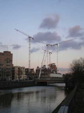 [Feb. 2008]
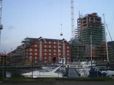
From the Island between Wet Dock and New Cut come the views below of (left) the network of masts, cables and cranes and (right) the fine maltings building on Albion Wharf – probably the most attractive period building on the dock – now refurbished with a liquid concrete hopper suspended from a crane jib hanging above it, and the skeletal concrete tower which replaces the earlier concrete tower next to the Custom House.
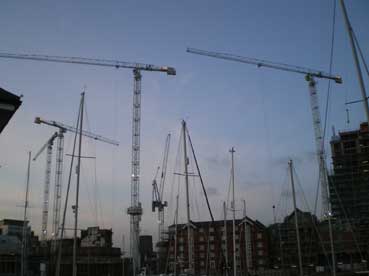
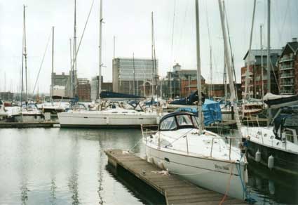
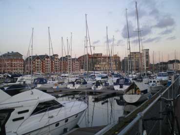
Below left: from New Cut West, not far from the Steamboat Tavern, the cranes don't seem quite so dominant. The last image looks down the Wet Dock from the island across a sea of rich people's cruisers and masts to the development at the other end: the Salthouse Harbour Hotel at the extreme left, past the apartment blocks, the new curving University building, Neptune Quay tower block and the beginning of the flats on Duke Street to the extreme right. Water, what water?]
In 2007/8 a global financial crash resulted from the collective madness of bankers, multinationals and politicians. This particularly hit Ireland where the bubble of credit folly had been notably overblown. Several of the developments on the northern quays had apparently been financed by Irish banks and the crisis put an end to work on the Waterfront. Huge blocks stand unfinished in 2014 and the ultimate testimony to 'development' hubris still stands in 2014: the skeletal building nicknamed by an sardonic populace 'The Winerack'.
 2013
image
2013
image
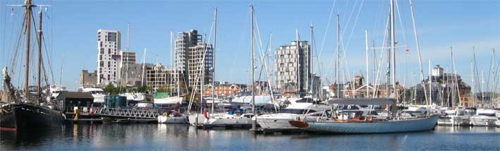
On the skyline above the vessels from the left: R.&W. Paul concrete silo, Burtons block (obscured), The Mill (tallest building in East Anglia and
home to DanceEast, but mainly unfinished and empty in 2013), Cranfield's, 'The Winerack', the redbrick
maltings on Albion Wharf, the chequered tower block above Pizza
Express, Premier Inn (in background, finished
2013), The New Custom House, Ashton KCJ (glazed maltings), Bistro on the Quay.
The irony is that we have, years after the crash, become used to the half-finished and barely started edifices surrounded by hoardings. At the other end of the dock the UCS university building was due to be joined by a development on the Ransomes Orwell Works site; by 2013 this was been postponed and the area left as a car park. On Monday 28 October 2013 gale force winds ripped polystyrene cladding and membrane from the waterfront face of The Mill's 23 storey tower block.
Related pages:
The Question Mark
Christie's warehouse
Bridge Street
Burton Son & Sanders / Paul's
College Street
Coprolite Street
Cranfield's Flour Mill
Custom House
Trinity House buoy
Edward Fison Ltd
Ground-level dockside furniture on: 'The island', the northern quays and Ransome's Orwell Works
Ipswich Whaling Station?
Isaac Lord
Neptune Inn clock, garden and interior
Isaac Lord 2
The Island
John Good and Sons
Merchant seamen's memorial
The Mill
Nova Scotia House
New Cut East
Quay nameplates
R&W Paul malting company
Ransomes
Steam Packet Hotel
Stoke Bridge(s)
Wolsey's Gate
A chance to compare Wet Dock 1970s with 2004
Wet Dock maps
Davy's illustration of the laying of the Wet Dock lock foundation stone, 1839
Outside the Wet Dock
Home
Please email any comments
and contributions by clicking here.
Search Ipswich
Historic Lettering
©2004 Copyright throughout the Ipswich Historic Lettering site: Borin Van Loon
No reproduction of text or images without express written permission
See also our page on Paul's maltings.
Fortunately for us, the archaeologists were able to carry out extensive digs in accessible areas in 2004/5 as this part of Ipswich was once the seething heart of the town dating back to the early Anglo-Saxon period. Indeed, revetments from those times were uncovered during the dig on the Cranfield's site indicating the original line of the quayside. It was also the home of one of the powerful religious establishments of the town: the Austin Cannons of St Peter & St Paul. The river level in earlier centuries (very pre-Wet Dock, 1842) was much lower and the river basin spread out; at the time of Wolsey's College the riverbank would have run up the centre of today's College Street, hence the presence of the surviving Wolsey Gate – the watergate of the college complex.
Moving round the site, past Burtons and St Peter's Church, the above photographs were taken from the Island between New Cut and the Wet Dock. Opening up views of the dockland churches for the first time, the demolition also stripped away the clutter, corrugated iron and prefab concrete which hid the original wharves. On the lower image we look eastwards down the quays to the flats near Neptune Quay. Henry Palmer's cast iron colonnade which carried Cranfield's Flour Mill over the dock on Albion Wharf to enable loading and unloading from ships in the dock. The upper photograph shows the further row of red coloured columns, now supporting nothing and awaiting the new structures.
May/June 2006
The following photographs form an album of images taken during the major demolition and clearance period of the regeneration scheme.
For a view of the back of this building, with its central arched tunnel, during demolition see below.
Above: a view of the northern quays from the Neptune Marina boatyard prior to the major demolition projects.
Above: watching it come down... The care taken by the demolition contractor is understandable with the proximity of the beautiful red brick building on Albion Wharf – yet another Paul's malting – and the Custom House (both visible in the photograph at left).
The close-up shows the lumps of concrete hanging from the reinforcement rods exposed during demolition. Presumably this feature made the piecemeal demolition process safer and ensured that heavy debris did not damage neigbouring structures.
Above left: a view of Albion Wharf from the island after the over-buildings were removed from the collonade. Above right: the Church of St Mary-At-The Quay exposed to view from the dock, possibly for the first time in centuries.
Above left: a view across the lagoon next to Stoke Bridge with buildings on St Peter's Wharf – the red brick Paul's maltings to the left (post fire), now demolished, the concrete Paul's silo, the white, soon-to-be butchered Burton's factory and the lower E.R. & F. Turner foundry buildings standing across Foundry Lane from the future site of The Mill/Jerwood DanceHouse. See our Trinity House buoy page for several more views of these buildings.
Above: the last of the Burtons lettering on the nascent, orange Cardinal Lofts block overlooking College Street.
Above: the Church of St Peter at left with the scaffolded Cardinal Lofts block rising to the right. The central silo is on the future site of DanceEast and The Mill.
Above: the view of the shrouded Paul's silo next to the Custom House at left, the 'stump' of the red brick Cranfield's mill at right with St Mary-At-The Quay in the centre, seen from Star Lane. See that page for photographs of that part of Cranfields taken from inside St Mary-at-Quay in 2008.
Above: two views of the rear of the red brick wharf building from the tiny Slade Street (the point where Star Lane and Key Street almost touch). The photograph at the left shows the central archway; it also shows some curving grey brick buildings which have been demolished by the time of the photograph to the right.
Above the spectral Paul's silo next to the Custom House part-way through demolition in the late afternoon sunshine, viewed from Star Lane.
Key Street with the red brick gabled buildings at the right which once stood close to St Mary-At-The Quay, also the huge banner covering the Cranfield 'stump'. The next few shots follow Key Street into College Street with a view of the orange Cardinal Lofts block opposite the Wolsey Gate.
Above: the gap between the Cranfields stump and Cardinal Lofts became the site of The Mill tower block incorporating DanceEast. See those pages for further images.
Below: apparently, a fire engine was required to be in attendance on the site throughout the demolition and clearance process. Felaw Maltings and the first modern block of waterside apartments (on Stoke Quay) can be seen across the dock and New Cut in the centre of the picture.
An impression can be gained of the enormous quantity of rubble produced during operations by the digger perched upon a sizeable mound (below).
Views from the Island before demolition of the gigantic silos to make way for the even more gigantic DanceEast tower known later as 'The Mill'.
Above: demolition clearance opened up the vistas both into and from the Wet Dock. Behind Cranfield's 'stump' is Church of St Mary-At-The-Quay, for decades screened off and dwarfed by heavy industry.
[UPDATE February, 2008: here we are on a late afternoon stroll round this (now) hub of construction and industry, rather than destruction. Below is the long shot from the Stoke side of the Gipping at high tide, with Stoke Bridge and the only surviving concrete silo – complete with 'R. & W. PAUL Ltd' lettering on St Peter's Quay plus the interlacing construction cranes on the Waterfront.
[Feb. 2008]From the Island between Wet Dock and New Cut come the views below of (left) the network of masts, cables and cranes and (right) the fine maltings building on Albion Wharf – probably the most attractive period building on the dock – now refurbished with a liquid concrete hopper suspended from a crane jib hanging above it, and the skeletal concrete tower which replaces the earlier concrete tower next to the Custom House.
Below left: from New Cut West, not far from the Steamboat Tavern, the cranes don't seem quite so dominant. The last image looks down the Wet Dock from the island across a sea of rich people's cruisers and masts to the development at the other end: the Salthouse Harbour Hotel at the extreme left, past the apartment blocks, the new curving University building, Neptune Quay tower block and the beginning of the flats on Duke Street to the extreme right. Water, what water?]
In 2007/8 a global financial crash resulted from the collective madness of bankers, multinationals and politicians. This particularly hit Ireland where the bubble of credit folly had been notably overblown. Several of the developments on the northern quays had apparently been financed by Irish banks and the crisis put an end to work on the Waterfront. Huge blocks stand unfinished in 2014 and the ultimate testimony to 'development' hubris still stands in 2014: the skeletal building nicknamed by an sardonic populace 'The Winerack'.
2013
imageThe irony is that we have, years after the crash, become used to the half-finished and barely started edifices surrounded by hoardings. At the other end of the dock the UCS university building was due to be joined by a development on the Ransomes Orwell Works site; by 2013 this was been postponed and the area left as a car park. On Monday 28 October 2013 gale force winds ripped polystyrene cladding and membrane from the waterfront face of The Mill's 23 storey tower block.
Related pages:
The Question Mark
Christie's warehouse
Bridge Street
Burton Son & Sanders / Paul's
College Street
Coprolite Street
Cranfield's Flour Mill
Custom House
Trinity House buoy
Edward Fison Ltd
Ground-level dockside furniture on: 'The island', the northern quays and Ransome's Orwell Works
Ipswich Whaling Station?
Isaac Lord
Neptune Inn clock, garden and interior
Isaac Lord 2
The Island
John Good and Sons
Merchant seamen's memorial
The Mill
Nova Scotia House
New Cut East
Quay nameplates
R&W Paul malting company
Ransomes
Steam Packet Hotel
Stoke Bridge(s)
Wolsey's Gate
A chance to compare Wet Dock 1970s with 2004
Wet Dock maps
Davy's illustration of the laying of the Wet Dock lock foundation stone, 1839
Outside the Wet Dock
©2004 Copyright throughout the Ipswich Historic Lettering site: Borin Van Loon
No reproduction of text or images without express written permission