Public warehouse, Tramway, Lock, Swingbridge, The Promenade
This triangle of land was formed
when New Cut was dug and a thin strip of land linked it with St Peter's
Quay (see our Wet Dock map if you're
confused). As we shall see there is a road/rail link across the lock
formed
by a swing-bridge at the other end.

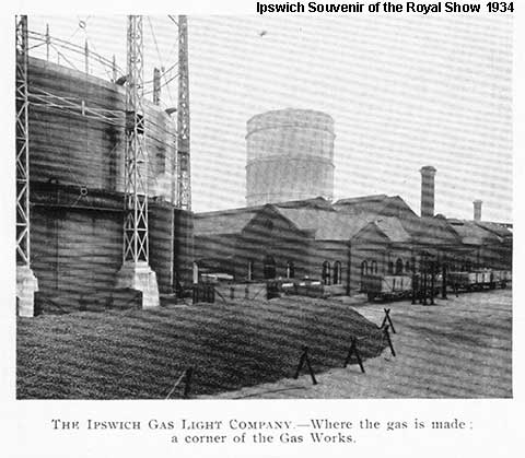
Above: the northern quays from Tovells Wharf, 1934. The gasworks on the eastern quay showing 'Jumbo', the giant timber-bound gas-holder which stood to the north of today's Patteson Road. This waterless gas-holder was a prominent landmark until its demolition around 1980.
The first historically lettered objects to be seen on the island are in a group of marine buoys which have been mounted and restored to welcome visitors to the island. We have included these on the Stoke Bridge Trinity House buoy page.
'Public Warehouse'
 2013
images
2013
images
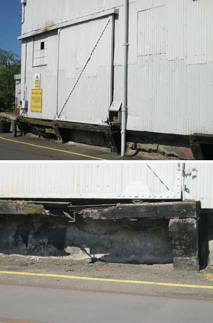
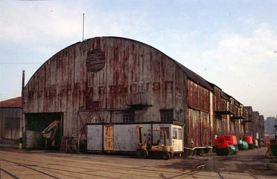
The warehouse with a curving roof, clad in corrugated metal is still in use, but by the look of the decaying timbers supporting sliding doors at the side (above), it has seen better days.
 1896 image
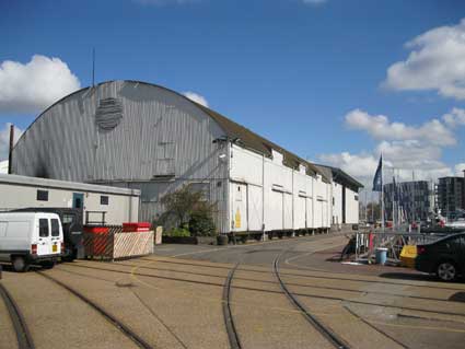
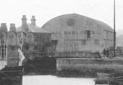
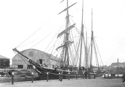
The Public Warehouse still stands at an angle alongside Public Warehouse Quay and was once clearly lettered (although the period image above shows that the 'E's were fading). In the 1896 image, above, the house to the left is the Lock-keeper's House shown boarded up and behind a fence in 2013, see New Cut East. Also note the round gabled Harbour Master's Office, the modern version of which is also shown on that page. The original western lock entrance of the Wet Dock is visible, so this view must be from New Cut. The original lock was replaced by the southern one we know today in 1881, but not immediately filled in (see our Wet Dock map page).
 1880s
photograph
courtesy Ipswich Maritime Trust
1880s
photograph
courtesy Ipswich Maritime Trust
This fine period photograph above shows a vessel in the original western lock approaching New Cut from the Wet Dock, with the clearly lettered Public Warehouse behind. It comes from the Ipswich Maritime Trust Occasional Paper No. 1 linked from our Wet Dock map page: "In 1882 an iron-framed public warehouse was built to the north of the original entrance lock, giving its name to Public Warehouse Quay, as seen in the photograph..., taken in the late 1880s. Remarkably, it stills stands today." The original lock, many would claim deliberately, required an awkward turn from New Cut to enter the enclosed dock. It was even more problematic for vessels wanting to enter from the Stowmarket direction. Eventually, the correct decision was made to create a new, southern lock which could be approached in a straighter line from the River Orwell.
 Photograph
courtesy The Ipswich Society
Photograph
courtesy The Ipswich Society
The third historic photograph from The Ipswich Society's Flickr collection (see Links) may depict the Public Warehouse in the 1960s/70s. A line of brightly coloured buoys line one wall with three loading gantries suspended above. The 'PUBLIC WAREHOUSE' lettering can still be read through the rusty discoloration of the corrugated iron. The Public Warehouse was built in 1880-81, designed by Thomas Miller. It has a 120 feet by 60 feet footprint. (Information from Bettley: Pevsner, Suffolk East, see Reading List.)
For an aerial photograph of the Island with the 'Public Warehouse' clearly visible, see our Lost trade signs page.
Tramway
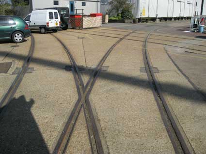
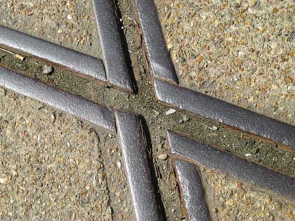
Below: the characteristic tramway lines and interchanges; far more are preserved on the Island than on the northern quays. For much more on 'a rat's-eye view' (see the traps in photographs below) of historic lettering and dockside furniture all round the Wet Dock see our Island at ground-level and northern quays pages.
 2013 images
As usual, the Ipswich Society website (see Links) is an invaluable source of scholarship. We can do no better than reproduce a slightly edited version of Ruth Serjeant's article from the IS Newsletter July 2009 (Issue 176).
"...[this] building, situated on the Island site, adjacent to what we now refer to as the old lock entrance in the New Cut. As some members may not have known about this building, now almost 180 years old and quite distinctive with its barrel shaped roof, I thought a few notes on its history may be of interest.
The opening of the Wet Dock in the 1840s brought increasing trade and shipping to Ipswich. Many businesses involved in the import and export trade built their own warehouses around the dock area, and while the Common Quay provided landing facilities for public use, there was little warehousing facility for the same public use - temporary storage for smaller amounts of goods in transit. This lack, and the ever-growing need to re-position the lock entrance to accommodate the larger ships that found difficulty in manoeuvring into the New Cut lock entrance, was finally recognised by the passing in 1877 of the Ipswich Dock Act. This gave the Ipswich Dock Commission the power to undertake these two improvements to the port as well as other associated works. In 1878 Thomas Miller, engineer to the Commission, presented' A Plan of Ipswich Dock and Port, showing proposed new work'.
Included in this plan is the site of a proposed wharf and warehouse where the Public Warehouse stands today.
A report to the General Committee of Management of the Commission was presented in November 1879 by the Warehouse Committee. This stated that though a temporary wooden shed had been originally proposed as a way of measuring the use of a warehouse, "it would now be highly desirable if a permanent iron building could be erected." This suggestion was accepted by the Commissioners and by March 1880 plans had been prepared by Thomas Miller for a substantial corrugated iron shed 120 x 60 ft with necessary provision to receive a second floor. Early in April 1880 the General Management Committee minuted that William Whitford & Co, Royal Ironworks, Commercial Road, London "had entered into contract ... at the cost of £1106". The contract was sealed by the Commission on 9 April 1880.
On the grand opening of the new lock on 27 July 1881 - the day that the new Post Office on Cornhill and the new Museum in High Street were also opened - the Ipswich Journal reported that "the Commissioners have erected a public wharf and warehouse for general trade, and approved plans for an extension ..... to be carried out as trade develops ... "
So began the working life of this new building. Some details of how it operated can be drawn from the Commissioners' minute books. In September 1881 an advertisement asked for tenders to be submitted for the three year tenancy, rental payable yearly. If the tenant in that period applied to increase the storage capacity by putting in the second floor with any consequent alteration to the ground floor and office accommodation, the Commissioners if agreeable would provide the capital outlay and charge the tenant 7 per cent upon the sum required, to be paid at the same time as the yearly rental. Three tenders were received - the highest one of £ 121 p.a. from Charles Henry Cowell, was accepted - it was stated that the other offers, both lower, had sought to effect changes in the conditions relating to interest to be paid on any capital outlay for extension works. The tenant, it must be assumed, would have responsibility to allocate storage space, charging users on the basis of a scale of rates laid down by the Commissioners. At the turn of the century we find that R W Paul Ltd were tenants. In 1900, as the only applicants to tender, they paid £175 p.a. rental, and in 1902, again as the only applicants, offered £125 which was agreed to.
There is no doubt that more could be found out about the use of the Public Warehouse from the sources I have looked at and perhaps from the recollections of any members who had any working association with it. I hope someone can add more to this short history.
Sources:
• Ipswich Dock Commission Records Ref EL1 Suffolk Record Office, Ipswich
• Ipswich Dock Commission (IDC) Minute Book 1875-1893, EL1/1/3/6
• IDC General Committee of Management Minute Book 1870-1881 EL1/1/4/5
• IDC Warehouse Committee Papers 1878-1911 EL1/1/9/5/142-189
• Plan of Ipswich Docks, Thomas Miller, 1878 EL1/7/5/7
• Iron Warehouse Contract Drawings, Thomas Miller, 1880 EL1/7/6/7 Ipswich Journal 30 January 1881"
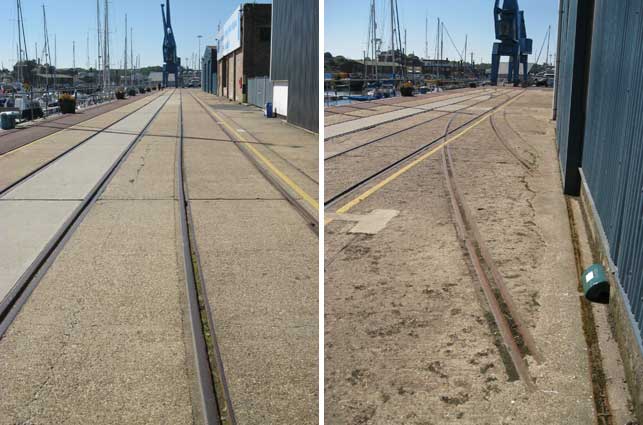
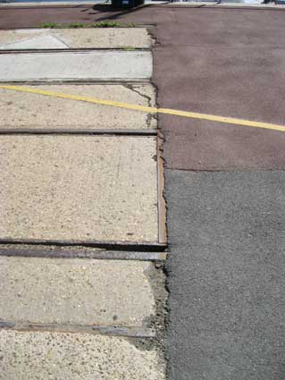
The tramway lines here have been preserved with newer concrete and tarmac infills. Clearly the lines could be switched right inside the warehouse entrance in the past. This make sense as it means loading and unloading as close to the source as possible. Compare with the tracks still visible in the former Ransome Orwell Works site on the other side of the Wet Dock. Close to the Babcock cranes, the tracks suddenly disappear:
A tramway is a set of rails laid in the surface of a road, rather than being raised on sleepers and a clinker bed. Although customarily used by tramcars in towns and cities in Victorian and Edwardian times (trams having had something of a rebirth in the late 20th century), these tramway lines have also been used by horse-drawn, steam and diesel vehicles particularly for the moving of freight wagons – exactly as we see around the Wet Dock and beyond (see our Wet Dock map page for an explanation of the growth of both rail and tramway access to the dockland area of Ipswich).
For more on lettered dockside furniture, see our Island at ground-level and northern quays pages.
Babcock & Wilcox cranes
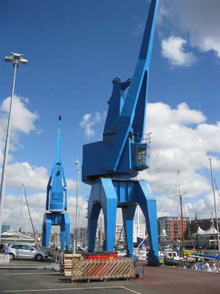
Further down towards the lock we find this pair of modernist cranes, well known to those who stroll down the western quays. There used to be three, but one was removed in the late 20th century. One can walk right underneath them. They are well-kept and well-painted with the relief lettering:
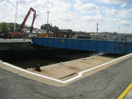
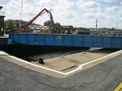
Swing bridge
The same dazzling blue paint can be found on the swing bridge and our photographs below show the bridge just beginning to move...
 2013 images
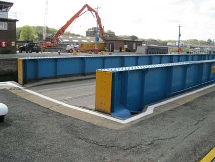
... and completely open as the lock gates eventually swing back to allow boats to leave the lock and pass out into the open river; the Tolly Cobbold Brewery on Cliff Quay is in the distance and the piece of land once called Hog Highland to the right.
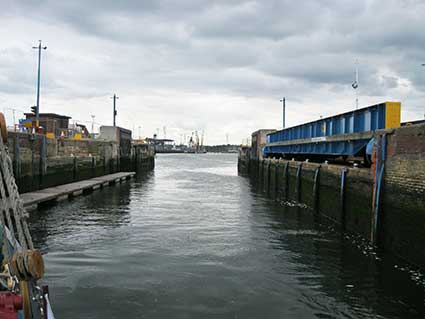
The southern lock used today officially opened on 27 July 1881, eventually replacing the original lock on the west of the Wet Dock. Below: views from inside the lock:
 2017 images
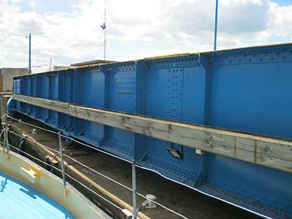
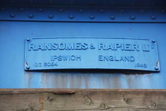
This swing-bridge was replaced in 1949 by a new bridge built by the Ipswich-based company Ransomes and Rapier. The new bridge, on which the metal tramway track can be seen (above) enabled freight traffic to reach Cliff Quay and the Cliff Power Staton avoiding the long, cluttered journey round the northern and eastern quays. (See Reading list for the Malster and Jones' book A Victorian vision.) It must have been quite a journey, leaving the main trackbed near the eastern end of the 'new' Ipswich station, down a curving incline, over the crossing at Ranelagh Road (near to Reavells foundry), over a bridge spanning the River Gipping, swinging round to run beneath Princes Street road bridge, onwards parallel with Commercial Road (now Grafton Way), past the sidings – site of the present-day Skate Park. Then, with Stoke Bridge traffic halted (possibly by men with red flags), over the level crossing, beneath the shadows of the R.W. Paul and Burtons towers, swinging right onto the Island, then all the way round past the Public Warehouse and down to the lock, over the swing-bridge, round onto Cliff Quay, past the brewery and way down to the long-demolished coal-fired power station.
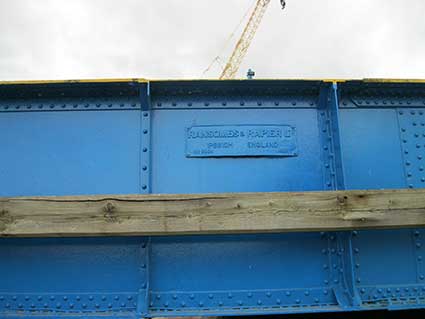
[Update 13.9.2014: we are indebted to John Norman for this photograph of the plaque on the swing-bridge, usually only visible from on board a vessel in the lock.]
 Photograph
courtesy John Norman
Photograph
courtesy John Norman
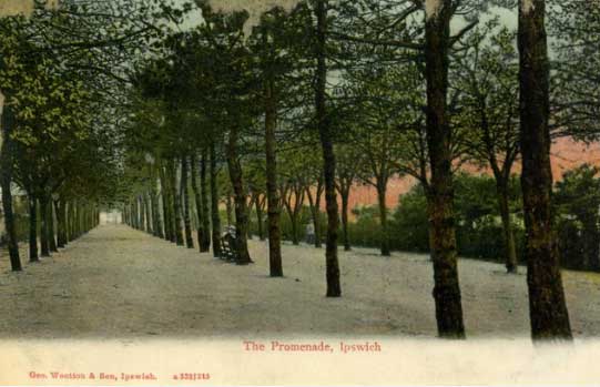
The Promenade
Looking at the Island sit in 2019, it is difficult to picture this spit of land between New Cut and the Wet Dock as a leafy area of public relaxation and recreation. As shown on the 1867 map on our Ransomes site page there were three linked parts to The Promenade at that time. Interestingly, the dockside we now call Helena Road (see Street name derivations) is a treed area labelled 'Marine Promenade East'; while many people will know about the the tree-lined walk on the Island, south of the first lock (still in existence in 1867 located on the west side of the Wet Dock and opening into New Cut) labelled on the map 'Marine Promenade West'. An avenue of trees labelled 'Mile End Road' is shown linking the two 'Promenades' across the site of the future south lock, opened in 1881, and extending to 'Clifton Road' – the line of today's Ship Launch Road. Members of the public were accustomed to promenading from just south of the western lock down to the Umbrella shelter (show as a circle on the map) and, if the map is to be believed, all the way round to the Gas Works, if they so desired.
 c.1914
image courtesy Nick Wiggin
c.1914
image courtesy Nick Wiggin
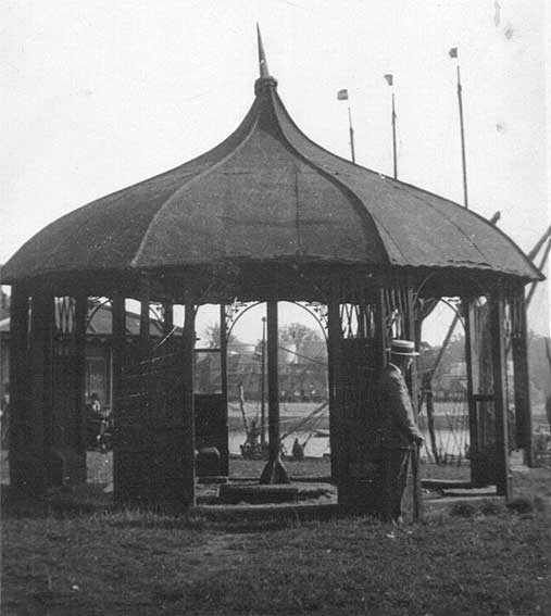
The above photograph shows the Umbrella with its characteristic shape, probably towards the end of its life judging by its condition, with a suited gent with walking-stick and boater. Sailing barges are moored on the south bank of the Island site with the River Orwell and Cobbold Brewery just visible. We assume that the structure visible in the left background is the cottage for 'the keeper of the Promenade' (see text below).
 c.1905
postcard courtesy Ipswich Maritime Trust Image Archive
c.1905
postcard courtesy Ipswich Maritime Trust Image Archive
The Promenade was a popular haunt of Ipswich people, particularly at weekends when they walked between the trees beside the New Cut and viewed the ships in the Dock. Laid out in the 1840s as part of the Wet Dock project, the Promenade stretched from the original entrance lock to the lower dam, site of the new entrance constructed in 1879-81; at the latter end were a cottage for 'the keeper of the Promenade', a shelter (known to everyone as The Umbrella) and a large staue of a winged horse. In 1912 the Dock Commission planned to end the public right-of-way along the Promenade and, though war the in 1914 meant that those plans were delayed, the Promenade eventually disappeared under the tramway lines. Nobody seems to have protested when the Dock Commission applied for the Act of Parliament which gave it the powers to closethe Promenade, but its loss has remained a matter of public regret ever since. [Information from Malster, R. Ipswich: an A-Z of local history, see Reading list.]
A photograph of the last days of the Promenade on the Maritime Ipswich Image Archive website shows ships, dockers, cargo and all the clutter of import/export of goods beside two remaining rows of trees forming a scant avenue for strollers. In the 21st century, some of the old Promenade is under concrete and remains behind security gates as 'New Cut East', although a regular stream of heavy lorries accessing this area from Stoke Bridge via St Peters Dock no longer occurs.
See also our Lettered castings index page.
See also our page on the Island at ground-level.
Related pages:
The Question Mark
Christie's warehouse
Bridge Street
Burton Son & Sanders / Paul's
College Street
Coprolite Street
Cranfield's Flour Mill
Custom House
Trinity House buoy
Edward Fison Ltd
Ground-level dockside furniture on: the northern quays and Ransome's Orwell Works
Ipswich Whaling Station?
Isaac Lord
Neptune Inn clock, garden and interior
Isaac Lord 2
John Good and Sons
Merchant seamen's memorial
The Mill
Nova Scotia House
New Cut East
Old Bell
Quay nameplates
R&W Paul malting company
Ransomes
Steam Packet Hotel
Stoke Bridge(s)
Waterfront Regeneration Scheme
Wolsey's Gate
A chance to compare Wet Dock 1970s with 2004
Wet Dock maps
Davy's illustration of the laying of the Wet Dock lock foundation stone, 1839
Outside the Wet Dock
Home
Please email any comments and contributions by clicking here.
Search Ipswich
Historic Lettering
©2004 Copyright throughout the Ipswich Historic Lettering site: Borin Van Loon
No reproduction of text or images without express written permission
Above: the northern quays from Tovells Wharf, 1934. The gasworks on the eastern quay showing 'Jumbo', the giant timber-bound gas-holder which stood to the north of today's Patteson Road. This waterless gas-holder was a prominent landmark until its demolition around 1980.
The first historically lettered objects to be seen on the island are in a group of marine buoys which have been mounted and restored to welcome visitors to the island. We have included these on the Stoke Bridge Trinity House buoy page.
'Public Warehouse'
2013
imagesThe warehouse with a curving roof, clad in corrugated metal is still in use, but by the look of the decaying timbers supporting sliding doors at the side (above), it has seen better days.
1896 imageThe Public Warehouse still stands at an angle alongside Public Warehouse Quay and was once clearly lettered (although the period image above shows that the 'E's were fading). In the 1896 image, above, the house to the left is the Lock-keeper's House shown boarded up and behind a fence in 2013, see New Cut East. Also note the round gabled Harbour Master's Office, the modern version of which is also shown on that page. The original western lock entrance of the Wet Dock is visible, so this view must be from New Cut. The original lock was replaced by the southern one we know today in 1881, but not immediately filled in (see our Wet Dock map page).
1880s
photograph
courtesy Ipswich Maritime TrustThis fine period photograph above shows a vessel in the original western lock approaching New Cut from the Wet Dock, with the clearly lettered Public Warehouse behind. It comes from the Ipswich Maritime Trust Occasional Paper No. 1 linked from our Wet Dock map page: "In 1882 an iron-framed public warehouse was built to the north of the original entrance lock, giving its name to Public Warehouse Quay, as seen in the photograph..., taken in the late 1880s. Remarkably, it stills stands today." The original lock, many would claim deliberately, required an awkward turn from New Cut to enter the enclosed dock. It was even more problematic for vessels wanting to enter from the Stowmarket direction. Eventually, the correct decision was made to create a new, southern lock which could be approached in a straighter line from the River Orwell.
Photograph
courtesy The Ipswich SocietyThe third historic photograph from The Ipswich Society's Flickr collection (see Links) may depict the Public Warehouse in the 1960s/70s. A line of brightly coloured buoys line one wall with three loading gantries suspended above. The 'PUBLIC WAREHOUSE' lettering can still be read through the rusty discoloration of the corrugated iron. The Public Warehouse was built in 1880-81, designed by Thomas Miller. It has a 120 feet by 60 feet footprint. (Information from Bettley: Pevsner, Suffolk East, see Reading List.)
For an aerial photograph of the Island with the 'Public Warehouse' clearly visible, see our Lost trade signs page.
Tramway
Below: the characteristic tramway lines and interchanges; far more are preserved on the Island than on the northern quays. For much more on 'a rat's-eye view' (see the traps in photographs below) of historic lettering and dockside furniture all round the Wet Dock see our Island at ground-level and northern quays pages.
2013 imagesAs usual, the Ipswich Society website (see Links) is an invaluable source of scholarship. We can do no better than reproduce a slightly edited version of Ruth Serjeant's article from the IS Newsletter July 2009 (Issue 176).
"...[this] building, situated on the Island site, adjacent to what we now refer to as the old lock entrance in the New Cut. As some members may not have known about this building, now almost 180 years old and quite distinctive with its barrel shaped roof, I thought a few notes on its history may be of interest.
The opening of the Wet Dock in the 1840s brought increasing trade and shipping to Ipswich. Many businesses involved in the import and export trade built their own warehouses around the dock area, and while the Common Quay provided landing facilities for public use, there was little warehousing facility for the same public use - temporary storage for smaller amounts of goods in transit. This lack, and the ever-growing need to re-position the lock entrance to accommodate the larger ships that found difficulty in manoeuvring into the New Cut lock entrance, was finally recognised by the passing in 1877 of the Ipswich Dock Act. This gave the Ipswich Dock Commission the power to undertake these two improvements to the port as well as other associated works. In 1878 Thomas Miller, engineer to the Commission, presented' A Plan of Ipswich Dock and Port, showing proposed new work'.
Included in this plan is the site of a proposed wharf and warehouse where the Public Warehouse stands today.
A report to the General Committee of Management of the Commission was presented in November 1879 by the Warehouse Committee. This stated that though a temporary wooden shed had been originally proposed as a way of measuring the use of a warehouse, "it would now be highly desirable if a permanent iron building could be erected." This suggestion was accepted by the Commissioners and by March 1880 plans had been prepared by Thomas Miller for a substantial corrugated iron shed 120 x 60 ft with necessary provision to receive a second floor. Early in April 1880 the General Management Committee minuted that William Whitford & Co, Royal Ironworks, Commercial Road, London "had entered into contract ... at the cost of £1106". The contract was sealed by the Commission on 9 April 1880.
On the grand opening of the new lock on 27 July 1881 - the day that the new Post Office on Cornhill and the new Museum in High Street were also opened - the Ipswich Journal reported that "the Commissioners have erected a public wharf and warehouse for general trade, and approved plans for an extension ..... to be carried out as trade develops ... "
So began the working life of this new building. Some details of how it operated can be drawn from the Commissioners' minute books. In September 1881 an advertisement asked for tenders to be submitted for the three year tenancy, rental payable yearly. If the tenant in that period applied to increase the storage capacity by putting in the second floor with any consequent alteration to the ground floor and office accommodation, the Commissioners if agreeable would provide the capital outlay and charge the tenant 7 per cent upon the sum required, to be paid at the same time as the yearly rental. Three tenders were received - the highest one of £ 121 p.a. from Charles Henry Cowell, was accepted - it was stated that the other offers, both lower, had sought to effect changes in the conditions relating to interest to be paid on any capital outlay for extension works. The tenant, it must be assumed, would have responsibility to allocate storage space, charging users on the basis of a scale of rates laid down by the Commissioners. At the turn of the century we find that R W Paul Ltd were tenants. In 1900, as the only applicants to tender, they paid £175 p.a. rental, and in 1902, again as the only applicants, offered £125 which was agreed to.
There is no doubt that more could be found out about the use of the Public Warehouse from the sources I have looked at and perhaps from the recollections of any members who had any working association with it. I hope someone can add more to this short history.
Sources:
• Ipswich Dock Commission Records Ref EL1 Suffolk Record Office, Ipswich
• Ipswich Dock Commission (IDC) Minute Book 1875-1893, EL1/1/3/6
• IDC General Committee of Management Minute Book 1870-1881 EL1/1/4/5
• IDC Warehouse Committee Papers 1878-1911 EL1/1/9/5/142-189
• Plan of Ipswich Docks, Thomas Miller, 1878 EL1/7/5/7
• Iron Warehouse Contract Drawings, Thomas Miller, 1880 EL1/7/6/7 Ipswich Journal 30 January 1881"
The tramway lines here have been preserved with newer concrete and tarmac infills. Clearly the lines could be switched right inside the warehouse entrance in the past. This make sense as it means loading and unloading as close to the source as possible. Compare with the tracks still visible in the former Ransome Orwell Works site on the other side of the Wet Dock. Close to the Babcock cranes, the tracks suddenly disappear:
A tramway is a set of rails laid in the surface of a road, rather than being raised on sleepers and a clinker bed. Although customarily used by tramcars in towns and cities in Victorian and Edwardian times (trams having had something of a rebirth in the late 20th century), these tramway lines have also been used by horse-drawn, steam and diesel vehicles particularly for the moving of freight wagons – exactly as we see around the Wet Dock and beyond (see our Wet Dock map page for an explanation of the growth of both rail and tramway access to the dockland area of Ipswich).
For more on lettered dockside furniture, see our Island at ground-level and northern quays pages.
Babcock & Wilcox cranes
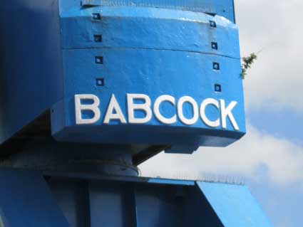
Further down towards the lock we find this pair of modernist cranes, well known to those who stroll down the western quays. There used to be three, but one was removed in the late 20th century. One can walk right underneath them. They are well-kept and well-painted with the relief lettering:
'BABCOCK'
picked out in white on the curved back section behind the
operator's cab. The American engineering firm of
Babcock & Wilcox opened its U.K. office in 1891. This pair of
industrial cranes seems to be quite modernist in design, suggesting
that they were built in the 1930s? It is hard to believe that this was
once a promenade for the fashionable citizens to take a Sunday stroll
between a double row of lime trees to 'The Umbrella' sheltered seats
with its views over Hog Highland and the River Orwell.Swing bridge
The same dazzling blue paint can be found on the swing bridge and our photographs below show the bridge just beginning to move...
2013 images... and completely open as the lock gates eventually swing back to allow boats to leave the lock and pass out into the open river; the Tolly Cobbold Brewery on Cliff Quay is in the distance and the piece of land once called Hog Highland to the right.
The southern lock used today officially opened on 27 July 1881, eventually replacing the original lock on the west of the Wet Dock. Below: views from inside the lock:
2017 imagesThis swing-bridge was replaced in 1949 by a new bridge built by the Ipswich-based company Ransomes and Rapier. The new bridge, on which the metal tramway track can be seen (above) enabled freight traffic to reach Cliff Quay and the Cliff Power Staton avoiding the long, cluttered journey round the northern and eastern quays. (See Reading list for the Malster and Jones' book A Victorian vision.) It must have been quite a journey, leaving the main trackbed near the eastern end of the 'new' Ipswich station, down a curving incline, over the crossing at Ranelagh Road (near to Reavells foundry), over a bridge spanning the River Gipping, swinging round to run beneath Princes Street road bridge, onwards parallel with Commercial Road (now Grafton Way), past the sidings – site of the present-day Skate Park. Then, with Stoke Bridge traffic halted (possibly by men with red flags), over the level crossing, beneath the shadows of the R.W. Paul and Burtons towers, swinging right onto the Island, then all the way round past the Public Warehouse and down to the lock, over the swing-bridge, round onto Cliff Quay, past the brewery and way down to the long-demolished coal-fired power station.
[Update 13.9.2014: we are indebted to John Norman for this photograph of the plaque on the swing-bridge, usually only visible from on board a vessel in the lock.]
Photograph
courtesy John Norman'RANSOMES &
RAPIER LTD
IPSWICH ENGLAND
GG 6054 1949'
For more on Ransomes & Rapier lettering see our Bourne Park page.IPSWICH ENGLAND
GG 6054 1949'
The Promenade
Looking at the Island sit in 2019, it is difficult to picture this spit of land between New Cut and the Wet Dock as a leafy area of public relaxation and recreation. As shown on the 1867 map on our Ransomes site page there were three linked parts to The Promenade at that time. Interestingly, the dockside we now call Helena Road (see Street name derivations) is a treed area labelled 'Marine Promenade East'; while many people will know about the the tree-lined walk on the Island, south of the first lock (still in existence in 1867 located on the west side of the Wet Dock and opening into New Cut) labelled on the map 'Marine Promenade West'. An avenue of trees labelled 'Mile End Road' is shown linking the two 'Promenades' across the site of the future south lock, opened in 1881, and extending to 'Clifton Road' – the line of today's Ship Launch Road. Members of the public were accustomed to promenading from just south of the western lock down to the Umbrella shelter (show as a circle on the map) and, if the map is to be believed, all the way round to the Gas Works, if they so desired.
c.1914
image courtesy Nick WigginThe above photograph shows the Umbrella with its characteristic shape, probably towards the end of its life judging by its condition, with a suited gent with walking-stick and boater. Sailing barges are moored on the south bank of the Island site with the River Orwell and Cobbold Brewery just visible. We assume that the structure visible in the left background is the cottage for 'the keeper of the Promenade' (see text below).
c.1905
postcard courtesy Ipswich Maritime Trust Image ArchiveThe Promenade was a popular haunt of Ipswich people, particularly at weekends when they walked between the trees beside the New Cut and viewed the ships in the Dock. Laid out in the 1840s as part of the Wet Dock project, the Promenade stretched from the original entrance lock to the lower dam, site of the new entrance constructed in 1879-81; at the latter end were a cottage for 'the keeper of the Promenade', a shelter (known to everyone as The Umbrella) and a large staue of a winged horse. In 1912 the Dock Commission planned to end the public right-of-way along the Promenade and, though war the in 1914 meant that those plans were delayed, the Promenade eventually disappeared under the tramway lines. Nobody seems to have protested when the Dock Commission applied for the Act of Parliament which gave it the powers to closethe Promenade, but its loss has remained a matter of public regret ever since. [Information from Malster, R. Ipswich: an A-Z of local history, see Reading list.]
A photograph of the last days of the Promenade on the Maritime Ipswich Image Archive website shows ships, dockers, cargo and all the clutter of import/export of goods beside two remaining rows of trees forming a scant avenue for strollers. In the 21st century, some of the old Promenade is under concrete and remains behind security gates as 'New Cut East', although a regular stream of heavy lorries accessing this area from Stoke Bridge via St Peters Dock no longer occurs.
See also our Lettered castings index page.
See also our page on the Island at ground-level.
Related pages:
The Question Mark
Christie's warehouse
Bridge Street
Burton Son & Sanders / Paul's
College Street
Coprolite Street
Cranfield's Flour Mill
Custom House
Trinity House buoy
Edward Fison Ltd
Ground-level dockside furniture on: the northern quays and Ransome's Orwell Works
Ipswich Whaling Station?
Isaac Lord
Neptune Inn clock, garden and interior
Isaac Lord 2
John Good and Sons
Merchant seamen's memorial
The Mill
Nova Scotia House
New Cut East
Old Bell
Quay nameplates
R&W Paul malting company
Ransomes
Steam Packet Hotel
Stoke Bridge(s)
Waterfront Regeneration Scheme
Wolsey's Gate
A chance to compare Wet Dock 1970s with 2004
Wet Dock maps
Davy's illustration of the laying of the Wet Dock lock foundation stone, 1839
Outside the Wet Dock
©2004 Copyright throughout the Ipswich Historic Lettering site: Borin Van Loon
No reproduction of text or images without express written permission