Bridge Street
Bridge Street today is barely noticeable: the stretches
of dual carriageway (and intermediate roundabout serving College Street
and Grafton Way) running from the roundabout in front of St Peter's
Church and the Novotel, across the bridges up to the beginning of
Vernon Street and Stoke Street. Interestingly, it also includes the
little slip road from the corner by the neglected No. 4 College Street
down to Stoke Bridge approach and the
St Peter's Wharf road to 'the
island' site.
 Photograph
courtesy The Ipswich Society
Photograph
courtesy The Ipswich Society
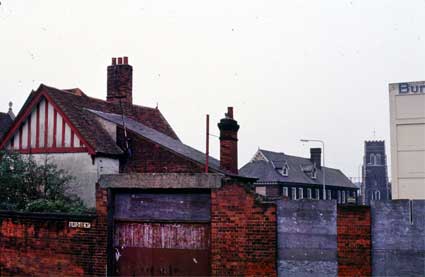
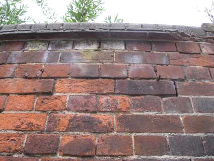
The photograph from the early-mid 1980s shown above from the
Ipswich Society's Image Archive (see Links)
shows a little seen view of the corner of Bridge Street and College
Street. 'Little seen' because, we deduce, the photographer was standing
on the grassy bank of the traffic island which separates the Bridge
Street slip road from the Grafton Way roundabout. The side and rear of
4 College Street are on the left, 1-5 College Street (the old Burton
Son & Sanders offices) are central, next is St Mary-At-Quay church
tower and the cream-coloured Burton factory block (which has now been
converted into the residential Cardinal Lofts with extra storeys added
in the 2000s) is on the right. The cast iron stereet nameplate is
visible centre-left on the red brick wall.
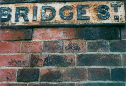
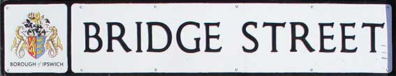
The cast iron sign bearing the
weathered
patina of many years,
with its superscript 'T' (similarly used in Northgate
Street with an unusual superscript 'VE' in Lloyds
Avenue) is shown below in situ
on the curving red brick wall.
 2000 images
and below the street sign what we at first thought were fire insurance
company medallions ('LVH,
18FT.' and 'LVS,
11FT.') [see
May
2011 update below]:
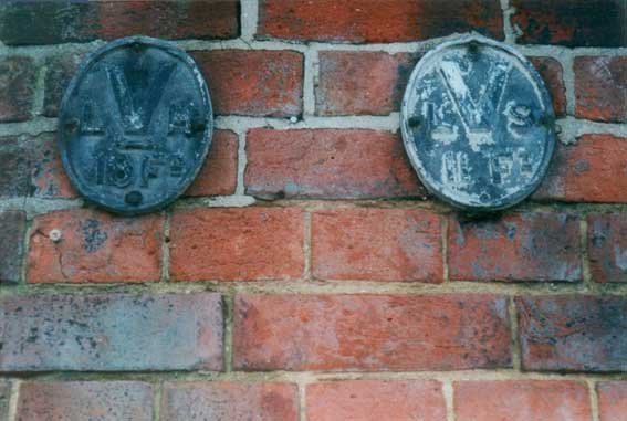
Perhaps inevitably, this lettering example was
noticed to have disappeared by late 2005. Presumably this was all part
of the radical Waterfront
Regeneration scheme
which was responsible for the removal of massive
unsightly old concrete structures and their replacement with massive
unsightly new concrete structures (cynics!). Or its disappearance might
have been due to metal thieves...
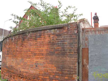
 2014 images
These 2014 images of the curving wall, still undoubtedly Bridge
Street – why did they remove the street nameplate? – show the site of
the sign. Above right: the rusted remnants of the lower brackets still
project from the brickwork. In the left photograph, the gable of 4 College Street can be seen, so this
wall occupies part of the space where number 2 College Street must have
stood. See our College Street page
for an 1890s view.
[UPDATE August, 2010:
The old, burnt-out St Peter's Maltings behind this sign has now been
demolished.]
[UPDATE May 2011: '... the
metal plates with a V in them are not fire marks or fire
plates; they indicate the position of valves on the water mains and are
of late nineteenth or twentieth century date. The fire marks issued by
insurance companies were much earlier, and were generally more ornate.'
We're grateful for this correction by Bob Malster (See Reading List). Indeed there are some fine
examples of the fire plates on the building frontages opposite the
Ancient House and elsewhere in Buttermarket.]
Other water valve markers can bee seen collected at
170 Foxhall Road (see our Rosehill house
names page), in the yard of the Sun Inn
and at Ivry Street (see our Street
furniture page).
Scroll down for a 2021 street sign on the south
section of Bridge Street.
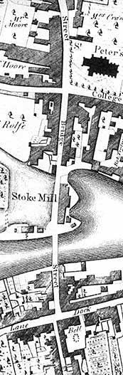 1778 map
On the 1778 Joseph Pennington map
detail, St Peters Street comes down from the north past the church; at
the junction with College Street it becomes Bridge Street. Passing the
tidal mill lagoon labelled 'Stoke Mill' it crosses the Orwell to
approach the staggered crossroads at The Old Bell. It is difficult to
imagine these closely-built roads in today's open street scene with the
skate park on the site of Stoke Mill, the reshaped St Peters Wharf and
lagoon, Novotel roundabout and Cardinal Park.
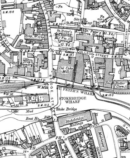 1902 map
By the 1902 map we can see that the tide mill to the west of the
bridge has gone and tide pool filled in, to be occupied by 'Mills (Corn
&c.)' served by the dock tramway. In the twenty-first century this
area is occupied by the skate park. The pool of St Peters Dock is
narrower, but Bridge Street is still shown as running from the Church
of St Peter/College Street south to the junction with Dock Street.
- Clearly labelled here are the Paul's 'Oil & Cake Mill'
on 'ST.
PETER'S WHARF' which burnt down;
- 'St. Peter's Iron Works' on Foundry
Lane run by E.R. & F. Turner;
- 'Roller (Corn)' on Cranfield's flour
mill site.
- Across the river is 'Stokebridge Maltings'.
- The
closely-built area on the south-west side of Bridge Street is seen on
old photographs, so different to today's open view.
- The same can be
said of the housing and business density on Great Whip Street, Dock
Street and Gower Street.
- Perhaps it is an indication of Victorian
appropriation of a medieval church, that St Peter is labelled 'St.
Peter's Church (Vic.)'.
- The 'Soap Works' shown to the west of St Peters
Street runs behind houses and shops; part of that site is now occupied
by the Novotel Hotel and its car park.
- The School shown south of this
backs on to another Iron Foundry: not, perhaps, an ideal site for
education.
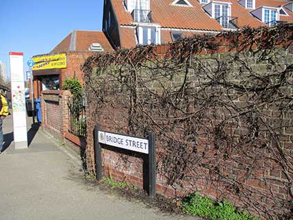
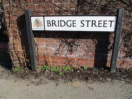 2021
images
2021
images
The above photographs show a modern street sign configuration using
plastic uprights and horizontal onto which the dtreet nameplate is
fixed. The additional lozenge to the left carries a colour depiction of
the Borough coat of arms with 'BOROUGH of IPSWICH' beneath it in sans
serif capitals, the 'of' in tasteful italics. The street name capitals
carry serifs with a maked 'kick', easily seen in the top bar of the
'T'. Stylish, but clearly read by passers-by, one hopes that the sun
won't bleach this sign – particularly the coat of arms which often
appears as a blank square frame in longer standing examples. The
convenience shop in the photograph (above left) was built onto the end
of Stoke Bridge Maltings; at extreme left, the curving part of Stoke Bridge can be seen.
Historical
significance
The importance of Bridge Street is indicated in
Keith Wade's paper: A history of
archaeology in Ipswich and of its Anglo-Saxon origins (see
'Special subject areas' on our Links page.):-
'At this [Middle Saxon]
period, there was also much activity
along the north bank of the River Orwell. A long sequence of timber
waterfront revetments, from the 7th century onwards, were found in
excavations at Bridge Street in 1981. The Middle Saxon waterfronts, of
simple post and wattle hurdle construction, were little more than a
bank protection, providing dry land on which to embark from the shallow
draft boats of the period, such as that found at Utrecht. More complex
timber structures were found more recently during excavations at the
Cranfields Mill site, east of Bridge Street. '
The
Grand
Ipswich
timeline gives much more information about the origins of Ipswich.
See our Stoke Hall
page for early maps showing Stoke Bridge and Bridge Street.
Related pages:
The Question Mark
Christie's
warehouse
Burton Son & Sanders / Paul's
College Street
Coprolite
Street
Cranfield's
Flour Mill
Custom House
Trinity
House buoy
Edward
Fison Ltd
Ground-level dockside furniture
on: 'The
island', the northern quays
and Ransome's
Orwell Works
Ipswich
Whaling Station?
Isaac Lord
Neptune Inn
clock, garden
and interior
Isaac
Lord 2
The Island
John Good and Sons
Merchant
seamen's memorial
The Mill
Nova Scotia
House
New Cut East
Quay
nameplates
Ransomes
Steam
Packet Hotel
Stoke
Bridge(s)
Waterfront
Regeneration Scheme
Wolsey's
Gate
A chance to
compare
Wet Dock 1970s with 2004
Wet Dock maps
Davy's
illustration of the laying of the Wet Dock lock foundation stone,
1839
Outside
the Wet Dock
Maritime Ipswich '82
festival
also:
College Street
Trinity House Buoy
R. & W. Paul maltings
Stoke
Bridge Maltings
and in Over Stoke: The Old Bell
and The
People's Hall.
Home
Please email any comments
and contributions by clicking here.
Search Ipswich
Historic Lettering
©2004 Copyright
throughout the Ipswich
Historic Lettering site: Borin Van Loon
No reproduction of text or images without express written permission