Charles Street and environs – a disappeared Victorian
housing estate
William Pretty
& Son corset factory, Footman's store
Dramatic changes on the maps
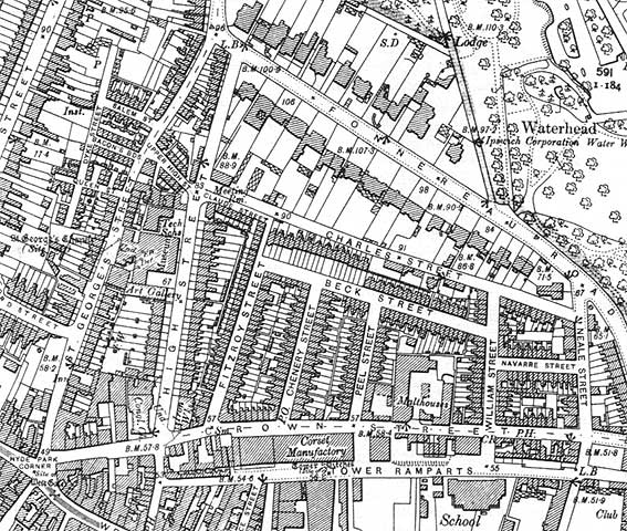
The 1902 map detail below shows Crown Street running
east-west towards the bottom. The triangle formed by Fonnereau Road and
High Street is the area of interest. A dense area of housing can be
seen
below Charles Street; in fact, the west side of Fitzroy Street is lined
with tiny houses with just a small yard behind. Compare this with the
large houses to the north along Fonnereau Road with their sizeable
gardens reaching back to Charles Street. Incidentally, as mentioned in
John Norman's piece about the old corstery factory (included on this
page), William Pretty senior lived and died in 61 Fonnereau Road, one
of those large houses.
As residential streets, the following have effectively
disappeared:-
- Beck Street,
- Chenery Street,
- Claude Street (as featured on
our Ipswich Museum
page),
- Fitzroy Street,
- William Street,
- Peel Street (although a stub of it is still named
south of Crown Street, behind Electric House),
- with just a few addresses on Charles Street and
Navarre Street.
However, as seen from the modern sketch map below, some
names have been preserved, albeit in reconfigured roads. It is notable
that the pedestrian access (steps/lift) to the car park from Crown
Street is still labelled as the southern part of Fitzroy Street (no
nameplate) – nowhere near the original position, itelf now shown as an
extension of Claude Street. Similarly, on the modern sketch map, this
the southern part of the extended Claude Street – a path leading
to Crown Street – is labelled (no nameplate).
 1902
map detail
1902
map detail
One or two interesting features on the 1902 map:-
- The Cricketers (for some years The Town House)
public house (opened 1930s as The Cricketers, a
'Tolly Folly')
on the corner of William Street and Crown Street doesn't exist.
- The former site of the large. Art Deco Egerton's works and showroom (built in 1928
and
demolished in the early 1960s – today the site is home to Crown Pools,
opened 1984) is occupied here by 'Malthouses'. There's also a chapel
('Ch') across the road, opposite the jaws of William Street; most of
the buildings in the strip between Crown Street and Tower Ramparts have
gone to make way for car parking, later the town bus station.
- However, Electric House
built 1933 (or rather, its predecessor) has survived and the large
'Corset Manufactory' of William Pretty & Son is now a car park.
This can be seen
in the background of an 1890 photograph of Tower Ramparts on our Carnsers page.
- At the confluence of St Georges Street, St
Matthews Street and Crown Street to the west is the enigmatic 'Hyde
Park Corner' – we still don't know why it's called this (please click
'Contact us' at the bottom of this page if you know).
- Note that the roads leading off St Georges Street to the
west after Bedford Street are Queen Street, Bacon's Buildings and Salem
Street (named after the Salem Chapel). The
second and third no longer exist and Salem Street is now an extension
of Dykes Street. For more on Dykes Street see our Lower Brook Street page.
- Opposite the old William Pretty & Son corset factory, streets and
housing to the north have been replaced by the large Crown House block
with its bus
and coach lay-by off Crown Street.
- Perhaps most striking of all is that, from the
old Temperance Hall at the corner of Crown Street and High Street (here
marked 'Iron Wks.' run from the Palladian building by Geo. Abbott –
shown on our More Schools page),
eastwards to the corner of William Street – future site of The
Cricketers –
then further to Neale Street and northwards to Charles Street almost
every building on the 1902 map has gone. In
1964 the Temperance Hall had been demolished, eventually to be replaced
by insurance offices: Churchill House, since refurbished and occupied
by accountancy offices. The period photographs
on this
page show that around 1965, the housing still stood.
In the 1960s the homes were declared unfit for habitation and almost
everything was demolished in 1966. The site was used as a surface car
park until 1975 when a concrete multi-storey was built ('Charles Street Car Park'*). We recall
parking on the tarmac'd area overlooking Tower
Ramparts before 1975; Ipswich open market was on that slope at the
time, later to be moved to the former site of Tower Ramparts School
(marked 'School' at the bottom of the 1902 map detail) –
part of the market's seemingly endless quest to find a permanent home
in Ipswich (still not properly settled in 2022...).
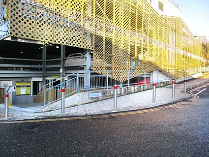
[*Charles Street Car Park was demolished in 2010 and replaced with a £5million
prefabricated steel structure called Crown Car Park (as shown in the
2022 Fitzroy Street photographs below). It includes multi-level and
outside parking area with electric vehicle charging points.]
Crown Street has seen many changes over the years. On Edward White's map of Ipswich 1867 we see it
labelled Clay Road with only the short western stretch from the
(unlabelled) Hyde Park Corner to High Street called Crown Street. This
street curving over the north of the medieval town and outside the
rampart became a convenient way of avoiding the congested, narrow
streets in the centre. It also became a street of many stables, inn and
houses; it lost its importance once the mail coaches were replaced by
the railways (1830s to 1840s).
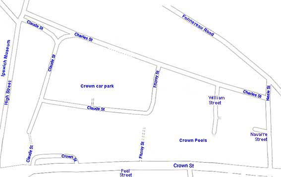 present day sketch map
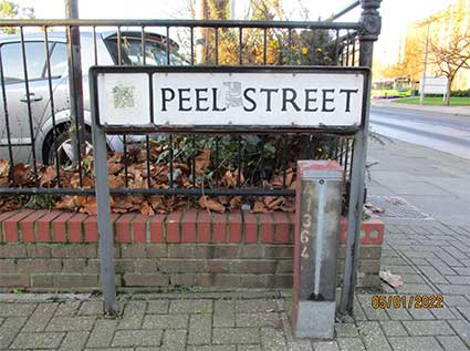
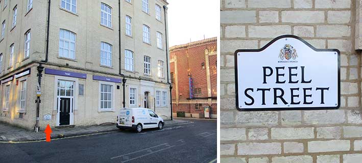
Here are the street nameplates in the area in early 2022...
Peel Street –
so short they named it thrice.
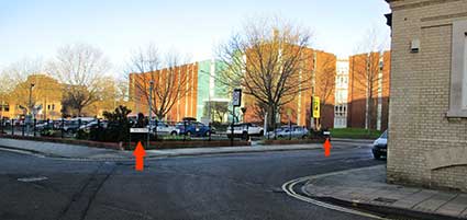
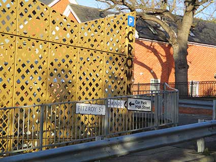
Above left: the car park which now occupies the site of
William Pretty & Son corset factory, showing two nameplates mounted
against the
railings. Crown House is in the background. Above right: on the corner
of Peel Street and Crown Street.
 2022 images
The red arrows indicate the three street nameplates.
The last of these, on the rear wall of Electric
House, features the more recent style of shaped plate with the Borough crest at the top.
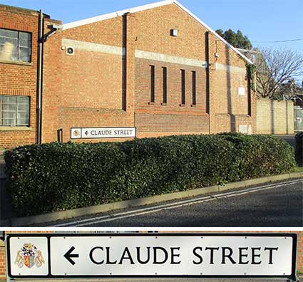
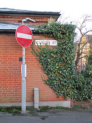
Claude Street–
extended extraordinarily with three nameplates.
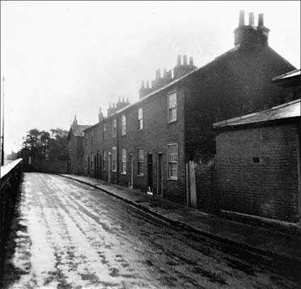 1960s
image
1960s
image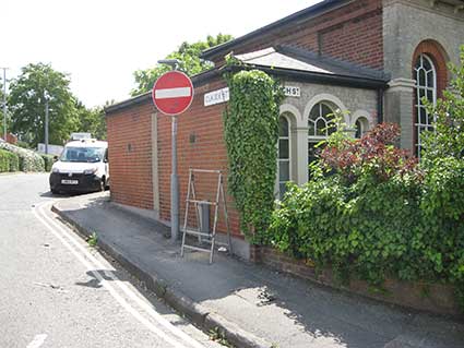 2018 image
The above atmospheric photograph shows the very short
Victorian Claude Street on a wet day in the 1960s, the chimney pots
shrouded by coal smoke and mist. The photographer is standing with his
back to the High Street, indeed the wall with its air vent at the far
right with its shallow roof still stands, as shown in the colour
photograph. It is the side of the Brethren Meeting Hall (now
residential), which fronts High Street. The vehicle visible occupies a
lay-by which was constructed after the houses were demolished. The
original Claude Street followed the line of Charles Street and is
divided from it by the brick wall at the left of the monochrome
photograph. At the far end, a narrow lane ran
south into Fitzroy Street (shown below) from just before the gable end,
as seen on the 1902 map.
 2022 images
The street nameplates to the north include one bearing
an arrow pointing to the High Street (presumably indicating the
present-day one-way nature of the original, short Claude Street); in
the
background is
the faint sign of H.H. Near Ltd, coach builders, as shown on our Vestiges page. The second (shown also on our Ipswich Museum page) shows a nameplate invaded
by the ivy which congests the house.
Meanwhile in the far corner of the site (shown below)
is another nameplate attached to the railings by steps leading down to
Crown Street.
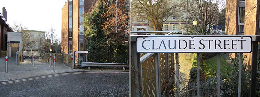
Below: the east-west extension of Claude Street seen
from each end; it continues past the car park entrances. The view on the right shows a vehicle entrance in the right
foreground which becomes a pedestrian passage to Crown Street.
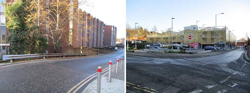
Below: the pathway from the Crown Street lay-by, which
modern maps sometimes label 'Claude Street'– although no nameplate is
here.
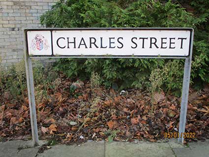
Charles Street
Given the parallel position of the extreme
western end of Charles Street and Claude Street (now designated as
one-way streets in each direction), there aren't any nameplates at this
end of Charles Street in 2022, but in 1985, see photograph from the
Ipswich Society Image Archive below right, there was one screwed
beneath the H.H. Near Ltd building window near the corner (the
free-standing 'Claude Street' sign with no arrow can be seen at the
extreme right). The Nears building is now used as the Ipswich Museum
store.
 1985
image
1985
image
Above left: the view looking towards High Street; the
white building at the end is The Arboretum public house – rechristened
'The Arbor' in about 2019. This photograph also shows the service road
branching off to the left which is kept gated. At the extreme left is
the upper level of the Crown Car Park which opened in 2018, replacing
the 1970s Charles Street Car Park block which suffered from 'concrete
cancer' and had to be demolished around 2010.
 2022 images
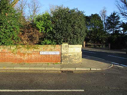
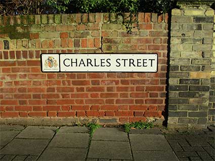
Above: the east end of Charles Street is very different
with a Victorian garden wall and street nameplate; the junction is with
Neale Street with (here) Fonnereau Road and Christchurch Park in the
background. Below: the free-standing sign near the southern corner.
See also the lettered Charles
Street gate.
The 1960s photographs below from the Ipswich Society
Image Archive (see Links) show how
closely-built Charles Street was in the 1960s.
 1960s images courtesy Ipswich Society
Above left: the rear yards of houses on Charles Street
sited downhill on the south side; they can be seen on the 1902 map just
below the 'CHAR' part of the street label. These houses fronted
onto
Beck Street (see also below) and have all been demolished.
Above right: the eastern end of Charles Street with Park House (Neale
Street elevation) at the end. The terraced houses on the right (south)
side have
gone to make way for William Street car park. The junction with William
Street can be seen at lower right.
William Street
 Comparison images
How it has changed. Above left: William Street with
houses and a shop (its window boarded up) on the upper west side,
1960s; in the background the large building in Charles Street. The junction at lower left is Beck Street (now vanished).
By 2022, the large building's concrete garages
(lettered 'NO
PARKING') are long gone; Crown Pools now stands to the left of this
view. The free-standing 'William Street' street sign can be seen in the
colour photograph.
 1945
image courtesy The Ipswich Society
1945
image courtesy The Ipswich Society
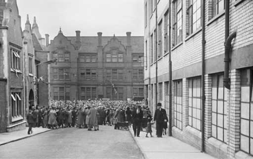
Above: Looking down William Street on VE Day, 1945. We
are so used to the open spaces hereabouts in modern times, it is odd to
see the street so hemmed in by, at left, the side wall of The
Cricketers – virtually unchanged. – and the mass of Egertons showrooms
on the right. Not only that, but the tall, three-storey Tower Ramparts Secondary Modern School blocks the view
across Crown Street and the car park closes the view – something
enhanced by the throng of revellers. This end of
William Street was pedestrianized in the late 1960s when Crown Street
was widened for the planned new ring road. Egertons on the right has
been replaced by Crown Pools. Tower Ramparts Bus station now stands in
front of the shopping centre, today called Sailmakers.
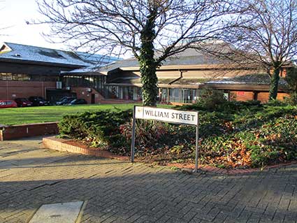
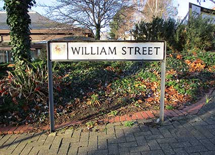 2022 images
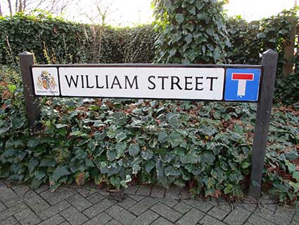
Above: the free-standing street signs at the western
and eastern jaws of William Street (respectively). Again, the heavily
built up street is transformed in the modern world and is now an access
to a car park and a footpath/steps from Crown Street between the pools
and The Cricketers pub; Crown Pools can be seen in the background of
the first two photographs.
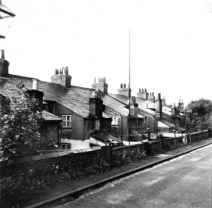
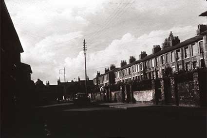
Beck Street
 1960s image
The above film noir-ish photograph is probably of Beck
Street which ran east-west below and parallel with Charles Street. The
road at the end would therefore have been Fitzroy Street (today
relabelled as an extended Claude Street). Fitzroy
Street, running north/south, is parallel and next to the High Street. See Street
name derivations for the
source of the 'Beck'. William
Street would have been behind the photographer. Now all houses have
been demolished, as has Beck Street itself.
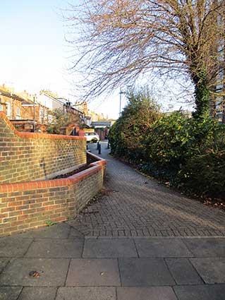
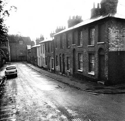
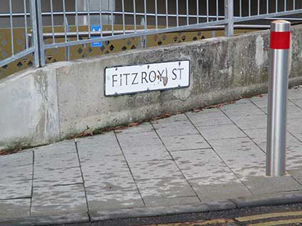
Fitzroy Street
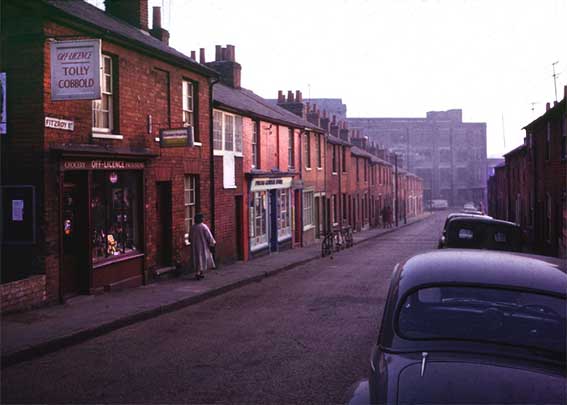 1965
image
1965
image
Well, here’s a fine mid-sixties view in glorious colour looking down
the
slope of Fitzroy Street (from the junction with Beck Street) – to prove
it there is a chunky cast iron street nameplate: ‘FITZROY ST.’
with characteristic superior ’T’ (examples of these can still be seen in situ around the town centre –
see Street nameplates).
The shop at left, a ‘proper shop’ which advertises ‘GROCERY,
OFF-LICENCE, PROVISIONS’, has two hanging signs. Tolly Cobbold had a
bit of a stranglehold on liquor outlets in Ipswich at this time
including corner shops; the other signs reads ‘Golden Virginia’
tobacco. Further down is ‘[?] GENERAL STORE’ which seems also to be a
post office. The dwelling between the shops has no ground floor window,
but a first storey loading door and windows; it appears to be storage
for
the general store. A third shop is next down the hill, with three
bicycles propped on their pedals against the kerb. Perhaps a little
surprising is the row of parked cars on the right-hand side. The
background is filled with Footman’s corset factory (initially built in
1881 – eventualy demolished 100 years later) across Crown Street.
It appears that the factory had extended westwards since the 1902 map
was drawn up – possibly after World War I.
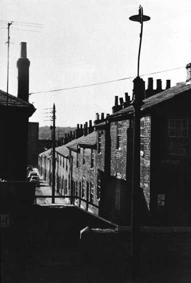 1960s
image
1960s
image
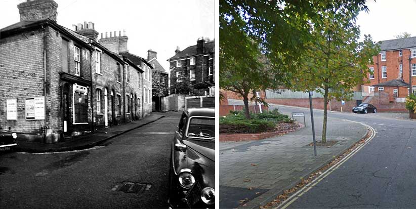
Above: an enigmatic photograph taken from Charles Street in the 1960s.
Just visible on the end wall to the right is a street nameplate:
'CLAUDE STREET'. This street dropped down from the level of Charles
Street, hence the steps in the foreground. The road directly ahead is
FItzroy Street with the silhouette of the corset factory at the end.
See Street name derivations for the
source of this name. The name Fitzroy Street has been preserved with
the building of the
multi-storey car park, but in a different place. The nameplates appear
on the access road from Charles Street to reach the new version of
Claude Street.
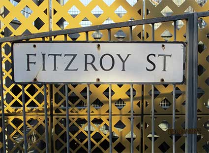
 2022 images
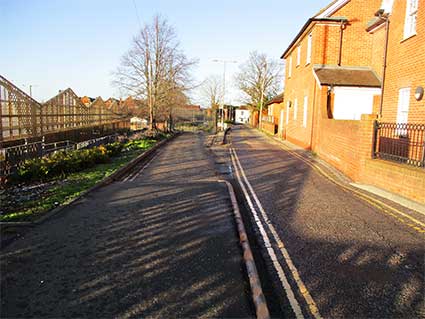
Above: the top of today's Fitzroy Street near the junction with Charles
Street. Below: the south-eastern corner of Crown Car Park with a
nameplate fixed low next to a pedestrian entrance. This is opposite the
Claude Street plate fixed to the railings (see above).
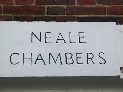
Neale Street
The street name here is enshrined in a building name:
'NEALE CHAMBERS'
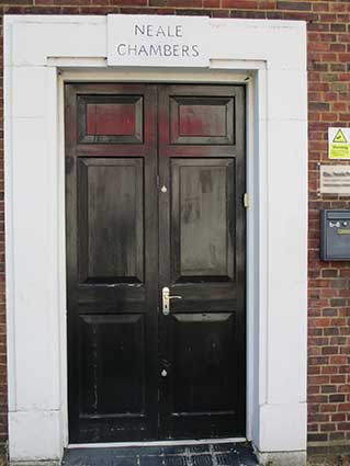
 2024 images
The rather spidery recessed characters are picked out
carefully in
black; the panel sits at the top of a simple Art Deco entrance.
2024 images
The rather spidery recessed characters are picked out
carefully in
black; the panel sits at the top of a simple Art Deco entrance.
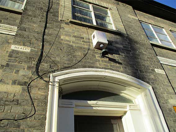
11(?) Neale Street bears the name 'NEALE ... HOUSE' inscribed on two
Suffolk white bricks above the porch. Within a few yards we are at the
junction with Navarre Street.
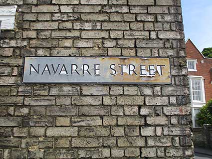
Navarre Street
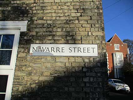 2022 images
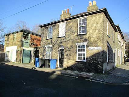
Above: the view of what remains of Navarre Street with,
at the right, Neale Street and 'Neale House' as shown above. By 2022
the
building to the left, which looks more of a works/storage building is
being held together with two bands around the upper storey. Planning
permission has been granted to convert this into accommodation, but
nothing appears to have been done yet. The road is blocked by a wooden
fence and the opposite side of the road is fenced, so there are only
two addresses in Navarre Street. There are about another ten houses
beyond this on the 1902 map running up to the William Street junction.
(See Street name derivations for the
source of the name.)
[UPDATE 21.6.2024: two years
after the above photographs, the works/storage building near the wooden
fence has been converted into accommodation (see below). In a
remarkably short time the effects of the sun on the street nameplate
have resulted in the loss of most of the white background colour; the
backward-leaning 'S' is also a curious feature of this example.]
 2024 images
It is perhaps ironic that, in the 21st century, Ipswich Borough Council
isencouraging more people to live in the town centre, while in the
1960s a large residential area of the town centre was demolished to
make
way for a multi-storey car park and swimming pool. Admittedly a
proportion of the housing
shown in the period photographs above was sub-standard, so there was a
case to clear the area. As town centres all over the country similar to
Ipswich are facing hard times for retail businesses and possible
reinvention as leisure centres, Ipswich is fortunate in attracting
smaller quality shops, specialist traders, restaurants, cafés and so on.
All 1960s photographs
are from the Ipswich Society Image Archive (see Links).
William Pretty & Son corset factory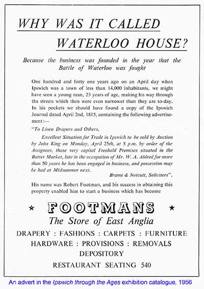 by John Norman
The car park in Tower Ramparts (behind Marks &
Spencer) was formerly the site of the factory of William Pretty, stay
and corset maker. Why, you may ask, was Ipswich a major centre in the
manufacture of corsets when we all know it was famous for engineering?
In addition to William Pretty’s there were a number of other corset
manufacturers in the town including The Atlas Corset Company of Lower
Orwell Street and Atlas House in Woodbridge Road, also E. Brand &
Sons of Tacket Street. Brand’s also ran a major department store, the
building is still there although the first floor has since been used as
a nightclub and is now residential accommodation.
Those with a greater knowledge of undergarments than I, have a better
understanding of the difference between stays and corsets. They are, I
understand, garments serving much the same purpose. The term ‘stay’
being the original terminology which was used during the 19th century
and the term corset being used in the 20th century (during which time
‘stay’ was a bone insert (of whalebone and later metal) used to
maintain shape (of the garment and the wearer). Ipswich has a place in
the whaling industry which may well have an initial bearing on the
supply of whalebone.
Corsets were one of the first mass produced garments. They had been
individually made since the 1550s and perhaps earlier (how else did
Henry VIII’s wives achieve such slim waists?). They became increasingly
popular again in the 1830s and, by 1850, mass production was essential
to meet demand. Although we use the term mass production, in the first
half of the 19th century this was still carried out in individual
homes, partially completed garments being moved from house to house. By
the 1850s these processes were being transferred into new factories and
by the 1870s it was a major industry in Ipswich.
 Throughout
the 19th and during the first half of the 20th century, Ipswich was a
major engineering town but this was an almost exclusively male
occupation. The women usually stayed home, gainfully employed as home
workers. Weaving had traditionally been carried out in the home but by
the mid-1800s the same mothers, wives and daughters were sewing and by
the 1880s they were using treadle sewing machines. It was logical
therefore to industrialise this workforce and move them into factories
where the process could be mechanised, productivity increased and
quality controlled, which is where William Pretty comes into the story.
Throughout
the 19th and during the first half of the 20th century, Ipswich was a
major engineering town but this was an almost exclusively male
occupation. The women usually stayed home, gainfully employed as home
workers. Weaving had traditionally been carried out in the home but by
the mid-1800s the same mothers, wives and daughters were sewing and by
the 1880s they were using treadle sewing machines. It was logical
therefore to industrialise this workforce and move them into factories
where the process could be mechanised, productivity increased and
quality controlled, which is where William Pretty comes into the story.
William Pretty was born in 1812 in Bacton, Suffolk, the son of a
draper; he left school at 13 and obtained an apprenticeship with John
Footman, draper of Stowmarket. In 1815 (the year of the Battle of
Waterloo) Footman opened a draper’s store in the Butter Market, Ipswich
naming the shop ‘Waterloo House’ to commemorate the famous victory. In
1834 Footman was joined by Alexander Nicholson and William Pretty,
opening a new Waterloo House in Westgate Street. William married in
1842 and his wife delivered a son, also William, who later joined the
family business.
Corsets and stays were being made to order in the rear of the shop but
they couldn’t keep up with demand so William junior persuaded his
father to build a factory on Tower Ramparts, an initial factory having
been built in 1858, although this was probably separate from what
became the much larger Tower Ramparts series of factory
buildings. These were started in 1881 and comprised four
storeys in Suffolk white brick, a massive project for its time. The
initial building was extended, perhaps three or four times.
Wm Pretty & Son was the largest employer of women in Ipswich. In
the late 1930s there were altogether more than 1,300 workers there.
Women were essentially machinists; males being employed in the
guillotining and material sections. However, the company could not
attract sufficient females to fill the production lines. William’s
solution was to open additional factories close to railway stations in
other Suffolk towns, cut the fabric in Ipswich and have it machined
into garments in the outposts.
These were then returned to Ipswich for boxing and dispatch, corsets
always being sold as a high-quality garment. Unfortunately for the
Pretty Company, the suffragettes with their ‘Dress Reform Society’
along with the First World War both changed the way women dressed and
corsets were no longer popular. William Pretty & Sons went into
liquidation in 1930; the business was purchased by R. & W.H.
Symington, an established corset manufacturer from Market Harborough.
The new owners kept the Wiliam Pretty brand name, built the business
and extended the factory. In 1968 Symington’s also went into
liquidation, the assets being taken over by the Courtaulds Group, the
famous textile, clothing, artificial fibres, and chemicals firm (who
also kept the Wm Pretty brand name).
The Ipswich factory closed in 1982, 100 years after it was originally
built, and was demolished in 1987. Although there have been plans to
build on the site, including an extension for Marks & Spencer, it
has been a car park ever since.
Additional information
William Pretty senior lived and died at 61 Fonnereau Road. When he
died, his widow sold the house to John Grimwade at the start of the
20th century. Their son, Colonel William Pretty, lived at Goldrood on
Belstead Road (later to become part of St Joseph’s College); he owned
the first motor car in Ipswich registered DX 1. Incidentally, in
White’s Directory 1874,
Frederick Footman (draper) is listed as living
at 59 Fonnereau Road. So the business partners were next-door
neighbours.
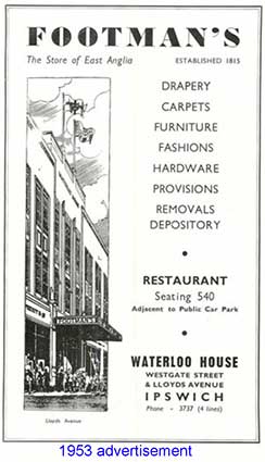
Footman Pretty became Footman’s and later Debenham Freebody & Co.;
Debenham’s department store replaced the previous Art Deco building
(presumably built in the 1930s) which was demolished and rebuilt in
large sections in the late 1970s. Debenhams store finally closed down
in 2021, a victim of changing shopping habits, the Covid pandemic and
such landmark stores being bought and sold for very little.
Note: Days Gone By by David Kindred
shows many photographs of the Art Deco store in its heyday.
Related pages
Our Cornhill 1 page has
information and images concerning Footmans department
store in Westgate Street, the forerunner of Debenhams. There are advertising illustrations of the Footmans store from 1905
and 1934 and some excellent packaging ephemera
sent in by
contributors on that page.
For Frederic Corder & Son, drapers of Butter Market and Tavern
Street, see our Ancient House page.
Corder's were rolled up into the future Debenham's store, too.
Old
shop signs and names
Lost
Ipswich trade signs with
sections on 'Before & after the Willis building' and Thomas
Seckford's 'Great Place' in Westgate Street.
Collage of lost
signs.
Brickyards, Potteries
, Ropewalks in
Ipswich
Also:
Named buildings list;
Named (and sometimes dated) buildings
examples
Dated buildings list; Dated buildings
examples; Dated
rainhoppers
and weather vanes
Origins of street names
in Ipswich; Streets named after slavery
abolitionists
Street index;
Street nameplates; Examples
of Street nameplates (Parliament Road
etc.);
Boundary
markers
Ipswich
Tomorrow, Greyfriars 1960s
Rampart and Town gates
Historic maps of Ipswich
Timeline: historical eras, events
and monarchs
Monasteries
Blue plaques
Freehold Land Society
Ipswich coat of arms
Pubs & Off licences
Wet Dock maps
Water in Ipswich
Listed buildings in
Ipswich
Windmills
in the Borough of Ipswich
Home
Please email any comments
and contributions by clicking here.
Search Ipswich
Historic Lettering
©2004 Copyright
throughout the Ipswich
Historic Lettering site: Borin Van Loon
No reproduction of text or images without express written permission